Cheonsang-yeolcha-bunyajido (hereafter, the C-map) is one of the representative star charts in East Asian history. The title, on translation, refers to an astronomical planisphere that shows celestial appearances in accordance with equatorial sectors and their astrological counterparts on the ground. This type of circular star chart, also called an extent chart (蓋圖, Kaitu), is known to have been originated as early as the former Han dynasty (Qian 1958). According to Astronomical Treatise of the History of the Sui Dynasty (隋書天文志, Suishu Tianwenzhi), one standard extent chart was compiled in 604 CE by Yu Jicai (庾季才) at the order of an emperor of the Sui dynasty, but currently it does not exist. An ancient example of Kaitu was discovered on the ceiling of the Kitora mural in Japan, constructed around 700 CE (Miyajima 1999). Another representative extent chart is the Suzhou1 planisphere carved on stone in 1247 CE on the basis of a copy of an earlier drawing from 1193 CE (Rufus 1945). A detailed account on the method of drawing this type of star chart is described in Treatise on Astronomy in New History of the Tang Dynasty (新唐書天文志, Xin-Tangshu Tianwenzhi).
The C-map was first investigated with a modern approach by Rufus (1913). The origin of the C-map is explained in the epitaph at the bottom of the stele. According to the epitaph, the C-map was carved in January 1396 CE based on a rubbing that had been obtained from an earlier stele. The source chart had been erected in Pyeongyang2, but it sunk into a river during a war. According to the epitaph, the astronomers working in the Royal Bureau of Astronomy of the Joseon dynasty (書雲觀) advised the King to revise the table that listed the stars culminating at dusk and dawn for the 24 seasonal grants during a year because the coordinates had been changed owing to the precession of equinox. Hence, Ryu Bang-taek3(柳方澤), an astronomer, revised the table by astronomical calculations. Sentences in the epitaph were written by Kwon Geun (權近), and the calligraphy was carried out by Seol Gyeongsu (偰慶壽).
Three versions of the C-map exist. One stele was erected in 1396 CE during the reign of King Taejo (太祖). That stele is now Korea’s National Treasure No. 228 and is preserved in the National Palace Museum of Korea in Seoul. Taejo’s stele has planispheres on both sides4. One side has a star chart whose title is located at the top part; henceforth that side can be called the T-map. The other side shows the title at the bottom, and so that side can be referred as B-map in abbreviation. The T-map shows a smooth and almost worn-out surface. It shows vague circles, but it does have neither an ecliptic circle nor radial lines for determinative stars. It can thus be concluded that perhaps the chart was not completed and was probably abandoned by intentionally smoothing out the surface. Then they must have used the other side of the stele to complete the project. Perhaps that is just because such a large stone was quite rare and hard to obtain at that time.
Another version is a woodblock-printed copy of the C-map. This version is considered to have been printed during the reign of King Seonjo (宣祖, r. 1567-1608 CE), which is based on the fact recorded in a historical record during the fourth year of King Seonjo’s reign in Joseon-Wangjo-Sillok5 that 120 rolls of planisphere were made and distributed to bureaucrats and nobles. In addition, according to the anthology of a famous Korean Neo-Confucian called Seong Hon (成渾, 1535-1598 CE), he was bestowed an astronomical planisphere from the King at the Royal Academic Seminar in the eighth month of 1581 CE. From this fact, we can see that the planispheres were occasionally bestowed to bureaucrats. Only two woodblock-printed copies are left now, and somehow both were present in Japan. Recenltly one copy was purchased and returned to Korea, and now it is housed at the National Palace Museum of Korea.
After 1600 CE, Taejo’s stele had been buried in a ruin because the palace was burned down during the Japanese invasions of Joseon (1592-1598 CE). Hence, a replica stele was built during the reign of King Sukjong (肅宗, r. 1674-1720 CE). This replica is now housed at the National Palace Museum of Korea and is designated as Korea’s Treasure No. 837. Furthermore, a number of rubbings of the Sukjong replica exist. Most of these replicas are preserved in Korea. However, one exception is the replica preserved in the Bibliothèque nationale de France; this fine rubbing was pillaged by the French Navy during the French invasion into Ganghwa Island in 1866 CE where the subsidiary division of Royal Library of the Joseon Dynasty was located (Ahn 2010b).
There are a few issues associated with the C-map such as its origin, the epoch of observation, and the possibility of revision. These topics are reviewed by Han (2007) and Koo (2007). However, little attention has been paid to the drawing method. In this study, I investigated the characteristics of the star chart and attempted to reconstruct the procedures for drawing the star chart in the C-map. In doing so, the drawing method of the extent chart described in Astronomical Treatise of Xin-Tangshu was consulted. Chapter 2 describes the characteristics of the star chart in the C-map, and Chapter 3 describes the reconstructed method for drawing the star chart. Chapter 4 describes the conclusion.
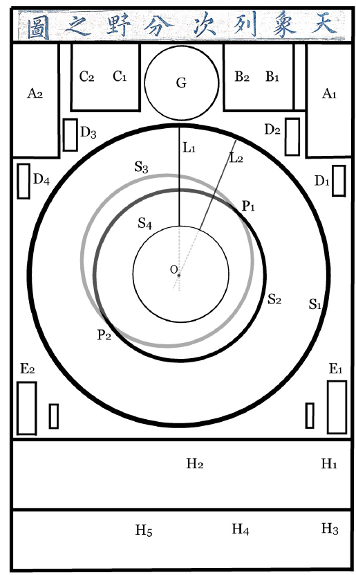
Fig. 1 shows a schematic diagram of the C-map6 (Cheonsang-yeolcha-bunyajido). The C-map, which is engraved on stone, comprises of 1,467 stars divided into 283 asterisms (Song et al. 2002). Three concentric circles can be observed while moving outward from the center of the star chart; for instance, the circle of perpetual visibility (S4), the celestial equator (S2), and the circle of perpetual invisibility (S1). The ecliptic circle (S3) and the boundary lines of the Milky Way can also be observed in the C-map. The circle of perpetual invisibility (S1) should be drawn with double lines in order to insert the sector names in it.
[Fig. 1.] Schematic diagram of Cheonsang-yeolcha-bunyajido. A1 and A2 are the right ascensions for the 12 equatorial sectors. B1 and C1 are the philosophical remarks for the Sun and the Moon, respectively. B2 contains the remarks for the Milky Galaxy, and C2 contains the explanation for the ecliptic and the celestial equator. Ds are the total angles for each of the four symbols of the Chinese asterisms. H1 contains the Chinese cosmologies, and H2 contains the coordinates of the determinative stars of the 28 lunar lodges. H3 contains the history of the chart. H4 contains the remarks advised for King Taejo written by Kwon Geun. H5 contains the list of participants that constructed this chart. G is the table of culminating stars at the dawn and dusk of twenty four seasonal grants. S1 is the circle of perpetual invisibility; S2, the equator; S4, the circle of perpetual visibility; and S4, the ecliptic. L1, L2, ..., and L28 are the determinative lines for the twenty eight lunar lodges. P1 denotes the vernal equinox, and P2 denotes the autumnal equinox. [the diagram was cited from Ahn (2011) and Ahn (2013).]
The projection method for the C-map is the azimuthal equidistant projection (Miyaj ima 1998), in which the distance from the center of the C-map to a star is proportional to the polar distance. Suppose that the stars in the C-map were observed by an observer located at a latitude ϕ. We can measure the radii r1, r2, and r4 of circles S1, S2, and S4, respectively, and then we can calculate the latitude ϕ from the ratios between those radii.
r1 : r2 = ϕ1 : 90°, r1 : r4 = ϕ2 : 180°-ϕ2, r2 : r4 = 90=5; : 180°-ϕ4.
According to Park (1998), r1=94mm, r2=222.4mm, and r4=361mm. ϕ1=38.0°=38.6 du ϕ2=37.2°=37.8 du, and ϕ4=33.9°,=34.4 du. These results are cross-versions with photographs of the three versions of the C-map in this study. It is interesting that when the circle of perpetual visibility is involved , the resultant latitudes yield approximately 38 du. On the other hand, when it is not involved, the resultant latitude yields 34 du. The meaning of these latitudes can be explained as follows.
Accroding to Astronornical Treatles of Xin-Tangshu, the outermost circle of a traditional Chinese Kaitu-style star chart is drawun with a bamboo-stick that has 147 regular ticks on it. This number 147 repersents the polar distance of the horizon in du. That is 180°-ϕ, where ϕ is the latitude of the observer. Hence, the latitude of the Chinese star chart described in Xin-Tangshu is calculated to be ϕ=35.1°. This latitude is of speical importance in the history of Chinese astronomers adopted this latitude as a reference in commemoration of Zhou Gong (周公), who is believed to have carried the earliest measurement of the sun’s shadow in Yangcheng (陽城). This place6 has been regarded as the center of Heaven and Earth in Chinese tradition7.
Presently there is a small town called Denfeng (登封) in Henan province China, where the Dengfeng Observatory is located. This ancient observatory forms part of the property Historic Monuments of Dengfeng in ‘The Center of Heaven and Earth’, which was inscribed on the World Heritage List. This includes the ancient architectural complex at Mount Song (嵩山) and the site of the Xia (夏) dynasty’s capital. Before the Tang Dynasty its name was Yangcheng, and according to classical Chinese texts, Emperor Yu (禹) the Great, founder of the Xia Dynasty, the first Dynasty in Chinese history, made Yangcheng his capital in the 21st century BC. It is believed in history that there was the Zhou Gong Observatory (周公測景台), and Guo Shuojing (郭守敬, 1231 - 1316) of the Yuan dynasty built the Gaocheng Astronomical Observator (登封觀星臺) in 1275 CE. The latitude of this place8 is currently ϕ=34° 27¢ 31.52=35.45875°=35.0 du. Therefore, it is evident that the star chart in the C-map is scaled in accordance with the idea of the traditional Chinese astronomy, whereas the radius of the circle of perpetual invisibility (S1) was adjusted to the latitude of Seoul. This adjustment was already pointed out by a number of researchers such as Park (1995) and Park (1998).
Since the star chart adopts the polar equatorial coordinate system, the center of the C-map should coincide with the north celestial pole (hereafter, NCP). I confirmed the concentricity of the three circles and determined the common center of the three circles using Euclidean geometry. Two methods can be used to determine the common center of the three circles. By one method, the center is obtained from the common intersection of extended determinative lines for the 28 lunar lodges. In the other method, the center is the intersection of perpendicular bisectors of arbitrary arcs for three concentric circles. Both methods give the common center as a star called Tianshuxing (天樞星), which means the celestial pivot or a pole star. The star is identified as HIP 62572 (or HD 112028, GC 17443) (Pan 2009, Ahn & Song 2015). This suggests that the C-map makers intentionally placed the Tianshu-xing at the center and drew the three circles with a compass, because they regarded this star as a pole star.
A pole star is a visible star that is approximately aligned with the Earth’s axis of rotation. The current northern pole star is the Polaris or a UMi. It is well known that the pole star has changed through history owing to the precession of equinox. In the Spring and Autumn Period and the Warring States Period in Chinese history, the Emperor Star or Di-xing (帝星), identified as β UMi, was a pole star. Tianshu-xing was designated as the pole star by the approximate period when the Western Han dynasty was replaced by the Eastern Han dynasty, approximately two millennia ago (Pan 2009).
I calculate the effects of the precession of equinoxes by using methods in Meeus (1998) to confirm that the angular distance from the NCP to the star was the smallest in 807 CE and its value was 0.54°. Thereafter, the relative distance increased with time, and the distance increased to approximately 3° around 1500 CE. Ganui (a simplified armillary sphere) part of Yuan-shi (元史, History of the Yuan Dynasty) clearly specifies the fact that in 1281 CE the Polaris was far from the NCP by 2.67°. The Ilsenong-jeongsu-ui(日星定 時儀, Sun and Star Dial), created by Korean astronomers in 1437 CE in the reign of King Sejong the great, was designed to align the instrument with the NCP using two stars: α UMi and Tianshu-xing. The C-map makers in 1396 CE were approximately contemporary with the Korean astronomers compiling the in the King Sejong period. Thus, the Korean astronomers compiling C-map must have been well aware of the fact that Tianshu-xing was too far from the NCP to be a pole star. Despite this, they set the center of the C-map at Tianshu-xing. This fact supports an idea that the C-map was not compiled on the basis of new observations.
In ancient East Asian countries, before the European Jesuits introduced the Babylonian 360° system, du (度) had been a unit for the celestial circumference. In the du-unit system, one complete turn equals 365.25 du. This unit originated from the fact that the Sun revolves once around the sky in one synodic year or 365.25 days. The star chart in the C-map shows 365 ticks along the circle of perpetual invisibility. These ticks are quite evenly spaced.
In the seventeenth century, the European Jesuits introduced the Babylonian degree system in China in Xiyang-Xinfa-lishu (西洋新法曆書, Calendrical Treatise in Accordance with the New Method). In this book, they described a practical method for drawing ticks in the star map as follows. “First, draw a circle, and then, obtain quadrants by intersecting two perpendicular diameters. Then, trisect each quadrant to obtain 30° segments. Next, divide each 30° segment into five equal 6° segments. Finally, divide each 6° segment into six equal parts, and therefore, we obtain 360 equal segments.”
However, this method cannot be applied to the case of 365 ticks because this number has only four divisors. Thus, the circumference is divided into equal segments whose chord lengths are calculated algebraically. That is, when a circle of radius r is divided into N equal segments (N>1), the length of a single chord, L, is L=2r sin(θ/2), where θ=2p/N or an angle corresponding to a segment between two nearby ticks on the circumference10. However, if there is no trigonometric table, it is impossible to obtain a proper chord length for an arbitrary number of segments.
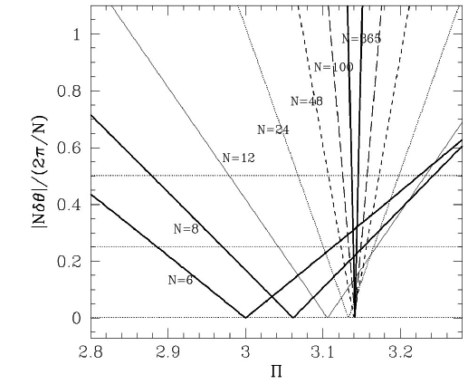
Hence, when an engineer use a compass and mark ticks on the circumference, it is probable that he or she adopted an arc length L′=2Пr/N instead of a chord length L. Here L′ is the length of one arc among N equal segments of the circumference. In addition to that, the p-value adopted by the engineer in the early Joseon dynasty was probably not the accurate value or π. Let us set the π-value he or she used to be П. We will obtain a bit larger angle θ′ given by θ′=2sin-1(П/N)
The difference between the practical angle θ′ and the exact value θ will be δθ=θ′-θ=2sin-1(П/N)-2π/N. Thus, the total error accumulated by the N-times of successive markings with a compass will be Δθ=ΣNn=1δθ=2N sin-1(П/N)-2π. In order to mark ticks in a proper manner, this total error should be at least less than one quarter of one tick interval. In other words, |Δθ|<α(2П/N), where we can assume α≅1/4. This is a bit subject criterion, but it is good in practical uses.
Fig. 2 shows the fractional error |Δθ| with respect to the angle corresponding to one tick-interval or (2π/N) as a function of П. One can see that the π-value should be 3.1394<П<3.1437 for N=365 and α=1/4 equivalent to 25% error for example . The π-value should be 3.1332<П<3.1489 for N=100 and α=1/4. Therefore we conclude that the engineer, who drew the star chart in the C-map, adopted П=3.14. This is an interesting result, because mathematicians, astronomers, and engineers of ancient times often adopted П=3. П=3.14 had been adopted only in unusual occasions.
In Fig. 2 we see that П=3 is practically applicable for dividing the circumference into a small number of segments or N≤9, and П=3.1 is sufficient for dividing the circumference into a small number of segments or 10≤N<24 within 25% error. As N→∞, the chord length approaches the arc length or L→L′ and equivalently П→π. It is also noteworthy that this result is independent of the radius of a circle. Pointing error occurring when we use a compass should be considered, but the pointing error can be small enough to be neglected for a sufficiently large circle such as that in the C-map.
Considering the history of π in the ancient Chinese mathematics (Needham 1959), the mathematical books such as Jiu Zhang Suan Shu (九章算術, 10th.2nd century BCE), Zhou Bi Suan Jing (周脾算經) (the Han dynasty), and Zhouli Kao-Gong-Ji (周禮 考工記) edited in the Spring and Autumn period adopted π=3. Liu Xin (劉歆, 53 BCE . 25 CE) used π=3.154, but it is not certain how he could obtain that value. Zhang Heng (張衡) adopted around 130 CE. Wang Fan(王蕃, 228-266 CE) π=142/45=3.1555 during the 3rd century. Liu Hui (劉徽, 225-295 CE) calculated 192 sided polygon. Later, Zu Chongzhi (祖沖之, 429-500 CE) living in the 5th century 3.1415926<π<3.1415927 with the method lost. In the 3rd century, Chen Zhuo (陳卓 c,330-c.420 CE) collected star charts of three schools to compile the Star Chart of the Three School (三家星圖). The π-values as accurate as 3.14 were available at that time to draw 365 ticks along the circumference. His followers were also able to use the sufficiently accurate value.
The outermost annulus of the C-map is segmented into twelve equal sectors, which correspond to Chinese equatorial sectors called cha (次) in Korean pronunciation (ci in Chinese pronunciation). The title of the C-map refers to these sectors, but in the rim of the star chart, the zodiac names are written instead of the names of the Chinese equatorial sectors. The zodiac was imported from India to China around the 6th century through Buddhist sutras (Pan 1989, Pan 2009). It is an important fact that the C-map was influenced by Buddhism astronomy, because Buddhism had been quite prevalent during the Goryeo (高麗) dynasty
Both the beginning and the ending lodge angle for each equatorial sector are given in panels A1 and A2 in Fig. 1. For example, “the sector of Xianxiao (玄枵) is from 8 du of Xunu (須女)11 to 15 du of Wei (危), encompasses 30 du in width, corresponds to the territory of the Qi (齊) state, belongs to Qing Zhou (靑州), and corresponds to the direction of Zhi (子方, Zhifang).” Sentences similar to A1 and A2 can be seen in Treatise of Astronomy (天文志) in Jinshu (晉書, History of the Jin Dynasty) written in 648 CE by historians of the Tang dynasty, except for the widths of the sectors (Song et al. 2002). These originated from Santong-li (三統曆, Triple Concordance Calendar) devised by Lui Xin (劉歆, 46 BCE-23 CE), which was adopted in Hanshu (漢書, History of the Han Dynasty) by Ban Gu (班固, 32-92 CE). The determinative star of Xunu (須女) is η Aqr, and the determinative star of Wei (危) is δ Peg. Thus, the upward North should have been defined in the star chart by the midpoint between 8 du east of η Aqr and 15 du east of δ Peg. That mid-point is by chance coincided with the determinative line of Wei (危). In East Asian tradition, the upward direction in star charts has been regarded as the North, called the direction of Zhi, whereas the downward direction is the South, called the direction of Wu (午方, Wufang). Hence, the meridian is called Zhiwu-line in East Asian countries. Hence, the upward North is set to be the determinative line of Wei (危) in the C-map. And the twelve sectors in the C-map were drawn in accordance with the information written in the tables A1 and A2. Hence, they were drawn after the 365 ticks had been drawn.
This fact is rather weird in view of the ancient tradition. According to Xin-Tangshu, the upward North direction in an extent star chart is defined by the direction of the winter solstice. The details are presented in the next section. According to Chiljeongsan naepyeon (七政算內篇, Domestic Part of Calendrical Method for Seven Luminaries), the epoch of a year in the legendary times of Yao (堯) was the winter solstice, which was located at 6 du of the lunar lodge of Xu (虛). Traditionally, this has been the beginning point of a year in ancient Chinese calendars. However, it is noteworthy that the upward North direction in the Suzhou star chart is also the direction of the determinative star of Wei (危). Hence the Zhiwu-line can be often spin off from the tradition, possibly for convenience sake.
I verified that the widths of all the sectors in the star chart were in exact agreement with the values in the panels A1 and A2. Furthermore, the widths of the lunar lodges represented by the determinative lines in the star chart are in exact agreement with those in the epitaph H2 in Fig. 1. The widths in H2 and A1,2 agree with the widths in the star chart. Thus, these facts indicate that the astronomers who compiled the C-map or built the original stele of the C-map faithfully utilized information in H2 and A1,2 when they drew the chart.
In ancient East Asian astronomy, the visible sky is divided into 28 lunar lodges resembling the cross section of an orange. The widths of the lunar lodges are different from one another. The western edge of a segment is the beginning of a lodge, which is aligned with its determinative star. A celestial object is said to lie in a particular lodge if it crosses the meridian in a certain segment. An angle equivalent to the right ascension of a celestial body, called the lodge angle, is measured west of that body with respect to the nearest determinative line. A polar distance of a celestial body, denoted by d, can be calculated as the radial distance at the Tianshu-xing or the pole star in the C-map. Then, d=90°-δ, where δ is the declination of the object in the equatorial coordinate system.
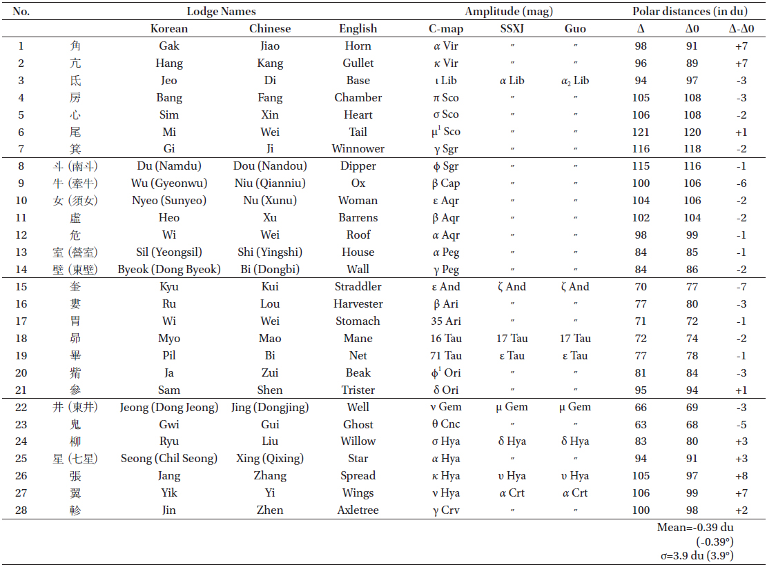
In the star chart of the C-map, the determinative lines for the 28 lunar lodges emanate from Tianshu-xing to the circle of perpetual invisibility and pass through the determinative stars. In other words, all the radial lines in the star chart pass through the determinative stars. This fact was also pointed out by Watanabe (1987). The spacing between the neighboring determinative lines (full widths of the lodges) and the polar distances of the determinative stars are tabulated in the H2 panel shown in Fig. 1. For example, the first lunar mansion is Jiao (角), which means Horn, and it comprises of two stars, of which α Vir or Spica is the determinative star. According to the table, its width is 12 du and its polar distance is 91 du. Thus, the determinative line of the next lunar lodge Kang (亢) locates eastward to the line of Jiao line by 12 ticks on the outermost circle of the star chart. α Vir should be plotted at a point where its radial distance from the center or Tianshu-xing corresponds to its polar distance. By the same procedure, all the other determinative lines and stars are plotted.
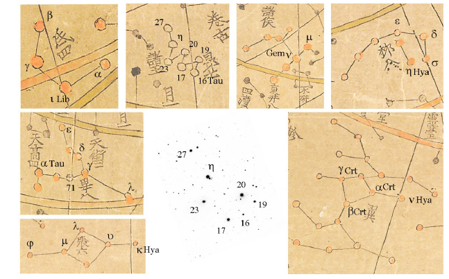
Ahn (2010a) investigated the 28 determinative stars in the C-map. He identified the determinative stars in the star chart of the C-map, and he also identified those stars in table H2 in Fig. 1 with a modern star catalogue. He determined that these two types of results were not in agreement with each other for at least seven determinative stars of lunar lodges such as Di (氐), Mao (昴), Bi (畢), Jing (井), Liu (柳), Zhang (張), and Yi (翼). Fig. 3 shows those seven determinative stars. The identification of the determinative star of Kui (奎) is uncertain. In ancient Chinese star catalogues, the determinative star of Kui has been ζ And. However, Watanabe (1987) identified this star in a Japanese star chart called Tenmonbunyanozu (天文分野之圖) with modern data, and determined that it must be δ And. It is noticeable that the Japanese star chart is considered to be influenced by the Korean C-map. However, the same star in the C-map is identified to be δ And. It is certain that the determinative star for Kui in the star chart of the C-map cannot be ζ And, which has been a determinative star by Chinese convention since the times of Yixing (一行, 683-727 CE).
The lunar lodge of Mao (昴) is quite compact, and thus the coordinates of its member stars could not be measured with a sufficient accuracy in ancient times. However, the detailed shape of Mao was magnified to be conspicuous enough for us to resolve its components. According to Shi Shi Xing Jing (石氏星經, Star Canon of Master Shi), the determinative star of Mao is the first star in the southwest. In Fig. 3, 16 Tau satisfies this description. However, 17 Tau has been the conventional determinative star of Mao in traditional Chinese astronomy.
Ahn (2010a) pointed out that there had been star charts in the Tang dynasty that had different determinative stars from the convention. The title of Volume 106 of Kaiyuan zhanjing (開元占經, Treatise on Astrology of the Kaiyuan Era) is ‘Star Charts (星圖)’. Kaiyuan zhanjing is known to have been written in 718-726 CE. According to that volume, the determinative stars of lunar lodges such as Jing (井), Liu (柳), and Yi (翼) in a new chart were different from those defined in an earlier chart. The volume 35 of Jiu-Tangshu (舊唐書, Old History of the Tang Dynasty) is Treatise on Astronomy (天文志), whose contents are recompiled in the volume 31 of Xin-Tangshu (新唐書). These volumes describe the new coordinates of determinative stars measured by Yixing (一行) by comparing with the previous coordinates in an earlier star-chart. According to the records in the two books, the determinative stars of Kui (奎), Liu (柳), and Zhang (張) in a new chart were different from those defined in the earlier chart. The current Chinese determinative stars were reformed in the early Tang dynasty. The anomalistic stars in the two literatures mentioned above are subsets of the anomalistic ones in the C-map. This indicates that the original chart of the C-map was compiled on the basis of the data of times earlier than the early Tang dynasty.
The other stars belonging to the 28 lunar lodges can also be plotted by referring the determinative stars plotted in the previous section. In the history of astronomical observations in China, the positions of the determinative stars were first measured during the former Han dynasty (Sun & Tian 1993). According to the Astronomical Treatise of Hanshu (漢 書天文志), Xianyu Wanren (鮮于妄人) organized a group of astronomers to observe the positions of the determinative stars. According to a book titled Fa Yan (法言, Comments on the Laws of Nature) written by Yang Xiong (揚雄) in 90 BCE, Luxia Hong (落下閎, 156-87 BCE) constructed an armillary sphere; Xianyu Wanren used the armillary sphere to measure the positions of the determinative stars, and Geng Shouchang (耿壽昌, 73-49 BCE) created a celestial globe (Sun & Tian 1993, Cullen 1996). In these facts, we have two important things to note. First, a sky globe and a Kaitu-style star-chart is convertible to each other. Second, these measurements were handed down to Shi Shi Xing Jing (石氏星經, the Star Canon of Master Shi). Sun & Tian (1993) analyzed the coordinates in this book and confirmed that the data were obtained in 60±30 BCE. However, his error was obtained using an incorrect formula, and the corrected error is ±160 years.
These coordinate values had not been changed till the seventh century, before the new observations of Li Chunfeng (李春風, 602-670 CE), Kaiyuan zhanjing, and Yixing (一行) appeared. The total number of stars in the Kaiyuan zhanjing catalogue is 120 (Sun 1994). A new star catalogue was compiled in 1034 CE in the Song (宋) dynasty by Yang Weide (楊惟德). This catalogue resulted from the measurements obtained during the Jingyou reign (景祐, 1034-1038 CE) and lists only 341 stars (Sun & Kistemaker 1997) Subsequently, Zhou Cong (周琮) compiled a new catalogue in 1052 CE, which is also called the Huangyou (皇祐) Star Catalogue; it resulted from the measurements obtained during the Huangyou reign (皇祐, 1078-1085 CE). It consists of 360 stars (Sun & Kistemaker 1997). Since there are 283 Chinese asterisms, this catalogue lists approximately one reference star per asterism. In the Yuan dynasty, Guo Shoujing (郭守敬, 1231-1316 CE) compiled a new catalogue of 741 stars in 1280 CE (Sun & Kistemaker 1997). The Jesuits of the seventeenth century catalogued a majority of the traditional Chinese stars. Adam Schall compiled a new star catalogue in 1628 CE. It consists of 1,365 stars (Sun & Kistemaker 1997).
The star chart in the C-map was compiled in 1396 CE, and thus, even if the C-map makers had adopted the new star catalogue of Guo Shoujing, only half of the total Chinese stars could be plotted from astronomical observations. The other half must have been plotted from the positions and shapes depicted on the original star chart. However, the C-map makers do not appear to have adopted Guo Shoujing’s observations because the determinative stars in the C-map are located at the position of epoch of approximately 50±170 CE (Ahn 2015a). Furthermore, the information on the linking lines can only be provided by either star charts or sky globes. A star catalogue alone cannot provide the information on linking lines. Therefore, I conclude that the C-map makers did not revise the original star chart. I speculate that only determinative stars in the original star chart of the C-map were plotted from observed coordinates such as those in the epitaph H2 of the C-map and that the other stars were plotted from the other earlier star chart.
I measured the distances of the determinative stars from the center of the star chart in the C-map and converted them into the du-unit assuming that the azimuthal equidistant projection was adopted in the C-map (Miyajima 1998). The results are shown in Table 1. The standard deviation of polar distances is as large as 4 du. These results are comparable to those obtained by Stephenson (1988). He obtained a similar result of 5° from the positional measurements of 20 of the brightest stars in the C-map when the precession of equinox is corrected to the epoch of 30 BCE. He conducted a similar analysis for 20 of the brightest stars in both the Su Song (蘇頌) star chart (1094 CE) and the Suzhou (蘇州) star chart (1193 CE). He obtained positional errors of 4° and 1°, respectively (Stephenson 1988). He ascribes the relatively small positional error in the Suzhou chart to the improvement in astrometry achieved during the Song dynasty.
The circle S3 in Fig. 1 represents the ecliptic. The radius of S3 is equal to that of S2. The ecliptic cannot be an exact circle in the projection method of the C-map. The locations of the equinoxes are given in the epitaph C2. According to C2, the autumnal equinox is at 5 1/6 du of Jiao (角), whereas the vernal equinox is at 14 1/3 du of Kui (奎). Inspecting the star chart of the C-map, we observe that the location of the autumnal equinox shows a better fit to the description in C2, whereas the location of the vernal equinox is approximately 10 du away from the description. Hence, the C-map makers drew the ecliptic as a circle by adjusting its center to an appropriate position to favorably fit the autumnal equinox at the desired position; i.e., at 5 du of Jiao (角).
The boundaries of the Milky Way are present in the star chart, and the Milky Way bifurcates in the vicinity of the Sagittarius region. The path of the Milky Way is described in books such as Treatise of Astronomy in Chenshu (晉書) that was edited by Li Cunfeng (602-670 CE). Zheng Qiao (鄭 樵, 1104-1162 CE) composed a poem in 1161 CE describing the path of the Milky Way based on its description in the treatise. The title of the poem is Tianheqimei (天河起沒, Drain and Source of the Milky Way), and it was included in the Butiange12 (步天歌, Songs of Sky-Pacers) of Tongzhi (通志) written by Zheng Qiao. The Bocheonga, including the Tianheqimei part, was published in Korea in the early period of the Joseon dynasty (Ahn 2009). If we compare the path of the Milky Way described in the C-map with that in Tianheqimei, we observe that they are in agreement with each other and that the northern and southern paths in the literature coincide with the boundaries of the eastern branch of the Milky Way in the vicinity of the Sagittarius region in the star chart. Further details will be published elsewhere (Ahn 2015b).
In this section, I describe the drawing method of an extent star chart as is outlined in the Treatise of Astronomy of Xin-Tangshu (新唐書天文志). The method is presented in the treatise in association with the explanation on the structure of the sky in the Kaitian theory (蓋天說) that was given by Yixing.
Step 1. Use the skin of bamboo13 to build a stick one fen (分) in width and half fen in thickness. Its length should be identical to that of the extent star chart.
Step 2. Bore a hole through the midpoint of the stick, and through this midpoint, insert a pivot pin that enables the stick to revolve.
Step 3. Carve 147 evenly spaced ticks starting from the central pivot and moving outwards14.
Step 4. Draw the circle of perpetual invisibility by revolving the entire bamboo stick of 147 ticks
Step 5. Draw a circle with a radius of 147 2/3 ticks, and this circle forms an annulus of thickness 2/3 tick, on which 365 regular ticks are drawn.
Step 6. Draw the equator circle with a radius of 91 1/3 ticks with the stick.
Step 7. Draw the circle of perpetual visibility with a radius of 35 ticks15.
Step 8. Calculate the position of the Sun at the winter solstice, and determine the exact center of each equatorial sector16.
Step 9. Use a stick of bamboo skin to measure on the sky globe the positions of all the bright stars belonging to the asterisms of Master Gan (甘德, Gande), Master Shi (石申, Shishen), and Master Wuxian (巫咸), and place points on the star chart using the same stick. The longitudinal coordinates are obtained from the lodge angles, and the vertical (or radial) coordinates are obtained from the polar distances.
Step 10. Divide the equator on the sky globe into 72 even segments, and measure the lodge angle of the midpoint of each segment. Next, extend the longitudinal line from the North celestial pole through the center of each segment, and determine the intersection of the line with the ecliptic. Then, with the stick of bamboo skin, measure the polar distance to the intersection. Next, draw the points on the extent star chart with the coordinate value. Connect these points to obtain the ecliptic.
Step 11. Xin-Tangshu elucidates the method of drawing the Moon’s paths on the star chart, but it is omitted in this here.
Reading the above mentioned method of the seventh century written in a Chinese treatise of the eleventh century, we observe that the star chart in the C-map can be reproduced by the same method. In order to draw the circles of both the equator and the perpetual invisibility, either the C-map makers or the original-chart makers adopted 35 du, which is the latitude of Yangcheng. However, they adopted 38 du for the circle of perpetual visibility; moreover, 38 du agrees with the latitude of Seoul. These facts indicate that they modified only the circle of perpetual visibility in order to represent the actual sky viewed in the observer’s location.
According to Xin-Tangshu, the upward North direction is the origin of the horizontal axis, and it should coincide with the right ascension of the winter solstice. A calculation shows that the winter solstice of 1396 CE was approximately at 9 du of Qi (箕). However, in the C-map, the upward North direction coincides with the determinative line of Wei (危), passing through its determinative star a Aqr. Another calculation also shows that the winter solstice of 2590 BCE was at α Aqr. The traditional origin of the calendar calculation in East Asian history was 6 of Xu (虛). The winter solstice was at this position around 2290 BCE. It is noteworthy that the legendary period of Yao was around 2200-2100 BCE. The upward North in the star chart of the C-map does not agree with these positions. Hence, I conclude that the C-map makers did not apply the method of defining an upward North direction as is described in Xin-Tangshu. Instead they set the Zhi direction (Zhifang) in accordance with the definition in Hanshu where the midpoint of Xunu (須女) 8 du and Wei (危) 15 du was defined to be the Zhi direction. That mid-point is by chance coincided with the determinative line of Wei (危); this definition is also written on the epitaph of the C-map and is explained in the previous section of this paper.
The ecliptic of the C-map was pointed out to be problematic by Yu (1999). The ecliptic is an exact circle that is congruent with the equator circle in the same star chart. This appears to be unusual. It is not certain whether the C-map makers of 1396 CE revised the ecliptic in the original chart. However, it is certain that only the center of the equator circle was adjusted to favorably fit the autumnal equinox in order to draw the ecliptic on the star chart.
In this paper, I investigated a method to draw the star chart in Cheonsang-yeolcha-bunyajido (C-map). The title of the C-map is translated as the star chart showing celestial appearances in accordance with the equatorial sectors and their corresponding states. I observed that the circles of the perpetual visibility, the equator, and the circle of perpetual invisibility were concentric, and their common center located the Tianshu-xing or HD 12287. This star was defined as the pole star in the Star Canon of Three Schools (三家星經, San Jia Xing Jing) written by Chen Zhuo (陳卓), who was a Royal astronomer during the reign of Wudi (武帝, Cao Cao 曹操, 155-220 CE) of the Wei (魏) dynasty. The star precessed into the closest position to the NCP in 802 CE, and around 1400 CE, when the C-map was compiled, the star became distant from the NCP by approximately 3°. This indicates that the C-map makers adopted a traditional but obsolete pole star, instead of the pole star of that time.
Further, I observed that the 365 even ticks are engraved on the stone along the circumference of perpetual invisibility. The 12 equatorial sectors are engraved in accordance with the beginning and ending lodge angles that are given in a table of the C-map. According to Treatise of Astronomy in Chenshu (晉書天文志), these values date back to the Santong-li (三統曆, Triple Concordance Calendar) devised by Lui Xin (劉歆, 46 BCE - 23 CE) in 7 BCE. Despite its title, the C-map adopted the zodiac names instead of the names of the equatorial sectors. The zodiac was imported from India to China during the early period of the Sui dynasty through Buddhist sutras. The north direction of Zhi (子方, Zhifang) in the C-map is set to coincide with the determinative line for the lunar lodge Wei (危), which indicates that the C-map makers simply adopted the table of the beginning and ending lodge angles that originated from the Santong-li of the Han dynasty.
All the determinative lines for the 28 lunar lodges radiates from the central star Tianshu-xing, and more importantly, their widths are in exact agreement with the intervals of the determinative stars listed in the epitaph of the C-map. These intervals originated from the Western Han dynasty and were recorded in the history book of the early Eastern Han dynasty. These intervals were changed in 724 CE in the Tang dynasty after a monk astronomer Yixing measured the positions of the determinative stars. I conclude that the C-map makers intended to draw the determinative lines for the 28 lunar lodges in exact accordance with the coordinates measured before the Tang dynasty.
I located all the determinative stars in the star chart by assuming that the stars are simply present on the determinative lines. I also identified the determinative stars with those in a modern star chart. Ahn (2010a) calculated the present positions of the determinative stars listed in the epitaph of the planisphere and identified the stars with those in a modern star catalogue. I compared these two results, and observed that there are seven anomalies that are different from the current Chinese convention, which formed after the eighth century in China. In order to understand this fact, a new fact I discovered in the Chinese treatises is beneficial. According to Xin-Tangshu and Kaiyuan zhanjing, there were earlier star charts in which a few determinative stars were defined differently from those defined by Yixing. In other words, Yixing’s new observations results in a new convention in China in the eighth century. Interestingly, these different determinative stars are included in the anomalies observed in the C-map (Ahn 2010a). Thus, in conclusion, the C-map preserves a rather old tradition, which is different from the Chinese convention redefined after the eighth century.
An epitaph on the C-map mentions that the celestial equator intersects the ecliptic at two points and that the eastern intersection is located at 5 1/6 du of the Jiao (角) lodge, whereas the western intersection is located at 14 1/3 du of the Kui (奎) lodge. The same sentences are present in Treatise of Astronomy in Chenshu that was compiled around 635 CE. It is known that these sentences describe the positional data observed by Luo Xiahong (140-87 BCE) of the former Han dynasty (Pan 1989). We can observe a remark at the location of the vernal equinox in the C-map: “the location where the ecliptic meets the celestial equator (黃道交處).” No remarks can be observed at the location of the autumnal equinox. However, the location of the vernal equinox in the star chart is not correct, whereas the location of the autumnal equinox is more accurate. The azimuthal equidistant projection is used in the C-map (Miyajima 1998), and thus the ecliptic cannot be a circle. However, both the ecliptic and the celestial equator are drawn as congruent circles in the C-map. In addition, the equinoxes in the star chart of the C-map correspond to the positions of equinoxes written in the epitaph of the C-map. Thus, the positions of equinoxes in the star chart are not useful in estimating the epoch of the star chart. The ecliptic in the C-map is not accurate and was not drawn in a way described in Xin-Tangshu.
I have confirmed that the C-map makers faithfully used the table of spans between the determinative stars observed in the C-map. Consequently, it is plausible for us to assume that they also used the table of polar distances in the C-map to engrave the stars at the correct position. I measured the position of the determinative stars in the C-map, and converted them into the polar distances. I observed that the positional error of the determinative stars in the C-map was as large as 4°, which is not so inaccurate when comparing with the intrinsic errors in the polar distances themselves.
In Xin-Tangshu, a treatise that describes the drawing method of the extent star chart can be found. Either the star chart in the C-map or the original star chart of the C-map must have been drawn using a similar method. However, the circle of perpetual visibility was modified in accordance with a latitude of 38 du instead of 35 du. The upward North direction was defined differently from the definition in Xin-Tangshu. The ecliptic circle was not adequate. It was drawn in a simplified manner. The determinative stars are depicted at their proper positions, which agree with the data of the Han dynasty. However, there are seven anomalistic cases that are different from the current Chinese convention, and these anomalies were also observed in the treatise of the Tang dynasty. In conclusion, the star chart in Cheonsang-yeolcha-bunyajido exhibits the sky of the former Han dynasty described in San Jia Xing Jing (Canon of Stars of Three Schools) by modifying the circle of perpetual visibility in accordance with the latitude of Seoul.


![Schematic diagram of Cheonsang-yeolcha-bunyajido. A1 and A2 are the right ascensions for the 12 equatorial sectors. B1 and C1 are the philosophical remarks for the Sun and the Moon, respectively. B2 contains the remarks for the Milky Galaxy, and C2 contains the explanation for the ecliptic and the celestial equator. Ds are the total angles for each of the four symbols of the Chinese asterisms. H1 contains the Chinese cosmologies, and H2 contains the coordinates of the determinative stars of the 28 lunar lodges. H3 contains the history of the chart. H4 contains the remarks advised for King Taejo written by Kwon Geun. H5 contains the list of participants that constructed this chart. G is the table of culminating stars at the dawn and dusk of twenty four seasonal grants. S1 is the circle of perpetual invisibility; S2, the equator; S4, the circle of perpetual visibility; and S4, the ecliptic. L1, L2, ..., and L28 are the determinative lines for the twenty eight lunar lodges. P1 denotes the vernal equinox, and P2 denotes the autumnal equinox. [the diagram was cited from Ahn (2011) and Ahn (2013).]](http://oak.go.kr/repository/journal/16023/OJOOBS_2015_v32n1_51_f001.jpg)