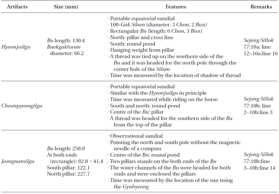
Various sundials were produced in King Sejong era. According to the record for the day of April 15 in the year 1437 in Sejongsillok (Annals of Sejong)1, a 40Cheok (scale unit) of Gyupyo (gnomon) was produced and it allowed accurate measurement at that time. Gyupyo, the most fundamental instrument to establish an independent astronomical calendar, was a giant sundial that determined the length of a year and 24 subdivisions of the seasons. In addition to Gyupyo, Hyeonjuilgu, Cheonpyeongilgu and Jeongnamilgu were produced in King Sejong era (Table 1). Hyeonjuilgu and Cheonpyeongilgu were the sundials produced on the basis of the equatorial plane of the celestial sphere. Jeongnamilgu, which had a more complicated structure than that of the equatorial sundials such as Hyeonjuilgu, also had included the characteristics of the observational instrument and the original sundial structure. The structure, method to use, principle and restoration design of Hyeonjuilgu, Cheonpyeongilgu and Jeongnamilgu were described in the main text focusing on the accomplishments obtained in the restoration procedures of them.
1Sejong sillok, 77:10a:line 12~10b:line 14.
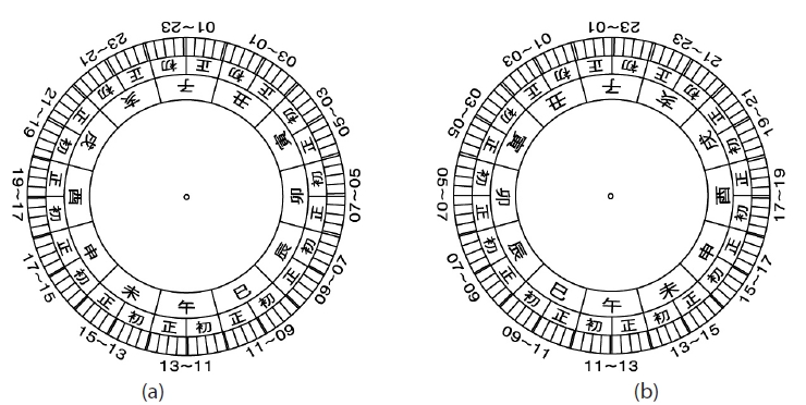
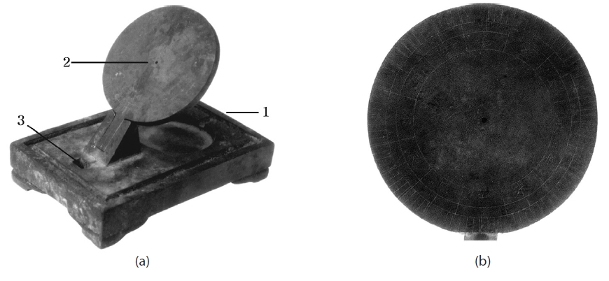
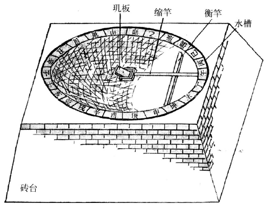
Hyeonjuilgu and Cheonpyeongilgu were portable equatorial sundials. With these sundials, the north-south direction was aligned with a magnet, and the time was measured by looking at the shade on the Siban face after leveling. Based on the record that Hyeonjuilgu and Cheonpyeongilgu had similar shape and size, it is assumed that not only the shape but also the methods to produce and use them were similar. Fig. 1 shows the artifacts of the remaining Ilyeongui (portable equatorial sundial) (a) and the enlarged image of 100-Gak Siban (round plate with one hundred intervals time lines) (b).
A round shaped Siban is fixed in the celestial equatorial direction on the base of the artifact. One hundred of angle marks are engraved at both sides of the Siban. There is a round pond under the Siban, which is connected with the water channels at the edge of the base. At the southern part of the base, there is a hole through which a knot can be made (1). The thread knotted at the southern part was to penetrate the center of the Siban (2). This indicates that the thread from the southern part of the base was aligned toward the pillar at the northern part of the base. The thread at the southern part of the base was lost, and only the rectangular groove (3) is remaining currently. The structure of this artifact is almost perfectly matched with Hyeonjuilgu mentioned in Sejongsillok. It is highly probable that Ilyeongui might have been the artifact corresponding to the prototype of Hyeonjuilgu.
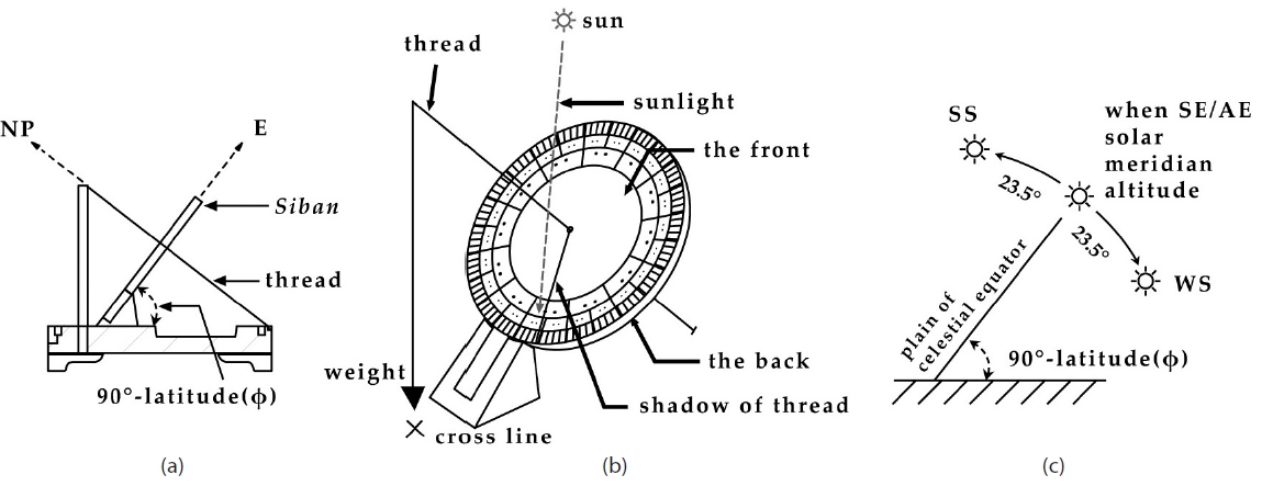
Fig. 2 shows the structure of Hyeonjuilgu and the variation of the solar meridian altitude. As shown in Fig. 2a, the thread penetrating the center of the Siban is laid in the direction of the earth’s axis of rotation (north pole: NP).
Thus, the Siban laid in the perpendicular direction of the thread represents the equator on the celestial sphere (E). Since the solar meridian altitude, the solar declination, is varied by the seasons, the shade of the thread falls on the upper plane or the lower plane of the Siban (Figs. 2b and c, Fig. 3). The shade falls on the mark over the Siban face from the spring equinox to the autumnal equinox and on the mark below the Siban face from the autumnal equinox to the spring equinox of the next year. The variation of the solar hour angle in a day determined the shade direction of the thread, announcing the hour. The water channels around the corners of the base was used for the leveling of the astronomical instruments at that time. In particular, the leveling of Hyeonjuilgu was more convenient because, in addition to the water channels, a bead was hung up to align it at the crossed lines below.
Two round ponds were placed on the base of Cheonpyeongilgu (Fig. 4), which was the structure produced by improving the one-pond structure of Hyeonjuilgu. In Hyeonjuilgu, the north-south direction is aligned by using a round pond at the southern part.2Then, the hour is read according to the direction of the shade on the Siban face. In summer, however, the time line on the Siban face was to be read at the northern side (in front of the Siban) and checking out the southern part (behind the Siban) to align the north-south direction was not convenient. Thus, the structure was improved in Cheonpyeongilgu to read the time more conveniently; the north-south direction was determined with reference to the pond at the northern part in summer and the pond at the southern part in winter.
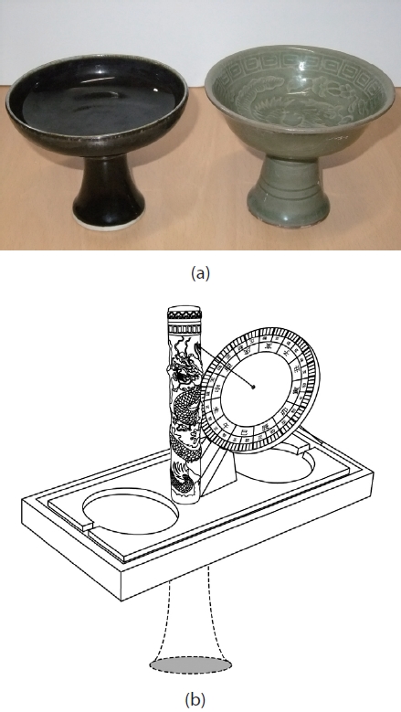
The record in Sejongsillok mentions that the time was measured with Cheonpyeongilgu on horseback. The instruments used on horseback usually have a handle. Fig. 5a shows the shape of a drinking cup used on horseback. If Cheonpyeongilgu was used on horseback, it might have been attached to the bottom of a drinking cup with a handle.3 Fig. 5b is the schematic illustration of the handle in Cheonpyeongilgu that is newly suggested based on the basic model of the drinking cup used on horseback. The four legs at the base of Cheonpyeongilgu were removed. Still, it may be almost impossible to have measured the time while riding on a horse. Perhaps the time might have been measured on the back of a stopped horse while not getting off the horse. The accuracy of the time measurement must have been lower than that of other sundials established on the ground such as Ilseongjeongsiui and Jeongnamilgu or Hyeonjuilgu that had cross lines.
Fig. 6 shows the equatorial sundial in the National Palace Museum in Beijing. A sharp perpendicular needle penetrates the center of the Siban face. The needle plays the same role of the thread penetrating the center of the Siban in Hyeonjuilgu. The time marks are engraved on the Siban face. An extra rotating instrument is located on the Siban face. The extra instrument in the equatorial equipment is the aspect different from Hyeonjuilgu and Cheonpyeongilgu, the sundials in King Sejong era. The extra instrument might have been to measure the time at night by observing the celestial bodies and considering the hour angle.
There is nothing known about whether or not there was a portable equatorial sundial in China at that time. Joseon may be the only country where a portable equatorial sundial was produced among the East Asian countries.This tradition might have helped the development to the portable Angbuilgu system in the latter part of Joseon Dynasty.
In the equatorial sundials of the traditional society, 30° of angle was divided to both the right and left sides with the solar meridian reference line at the center, allocating the same interval for one Sigan (corresponding to two hours at present). Each Sigan was divided into Cho and
Jeong in the same interval, and thus the system was identical to the current 24-hour system. However, the time used in the era was true solar time, not mean solar time that is currently used.
Twelve time lines drawn on the equatorial face were generated by the rotating earth. Thus, even though the solar elevation is varied on the meridian line, the twelve equal intervals are still valid because the earth’s rotation is constant. For example, the solar meridian elevation is 76° on the summer solstice in the location of 37.5° latitude.The earth’s rotation is constant as 30° for each hour with reference to the equatorial plane regardless of the solar elevation, the marks on the Siban face of equatorial planes can be still used. As already shown in the previous studies, the time was measured in the same manner in the observation instruments where the Baekgakhwan was installed as the equatorial plane such as Ganui, Soganui and Ilseongjeongsiui (Lee 1996, Lee & Nam 1998, Lee & Kim 2002, Kim 2007).
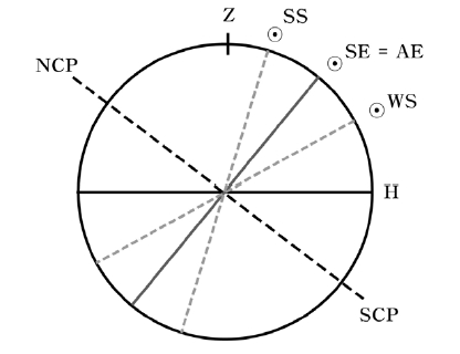
Fig. 7 shows the meridian elevation by the horizontal coordinates system where Z denotes the zenith and H the horizontal plane. The polar axis (south celestial pole: SCP, north celestial pole: NCP) of the celestial sphere rotates the equatorial plane. When the sun is located on the equatorial plane of the celestial sphere, the season corresponds to the spring equinox (SE) and autumnal equinox (AE). On that day, the solar meridian elevation is 52.5° at 37.5° north latitude.4The variation of the solar meridian elevation is +23.5°~-23.5° with the horizontal plane at the center. Thus, the solar meridian elevation is the highest as 76° on the summer solstice (SS) and the lowest as 29° on the winter solstice (WS). In the case of equatorial sundials in which the equatorial plane is fixed, the time is read on the shade line generated by the thread onto the front face and the rear face of the equatorial plane Siban because the solar meridian elevation is varied up and down.
2The north-south direction alignment method using a magnet floated on the water in a round pond may be the most probable method applied to the instruments that could be established at a certain place such as Ilseongjeongsiui and Jeongnamilgu. However, a more careful approach should be taken about whether or not a magnet (magnet needle) was floated on the water in a round pond for the small, portable instrument to set the north-south direction. The portable instrument, Angbuilgu, used in the latter part of Joseon dynasty provides a clue for that; the compass system of the portable Angbuilgu might have been used as it is fixed in the round pond of Cheonpyeongilgu. This may be applied to the portable sundials such as Hyeonjuilgu and Cheonpyeongilgu. We will analyze this in detail in further studies.
3Mihn Byeong-Hee (Korea Astronomy and Space Science Institute, researcher) suggested the necessity of a handle in Cheonpyeongilgu in the presentation at the Conference of the Korean Space Science Society (October 29, 2010). The suggested model included the pillar of Cheonpyeongilgu extended to the upper direction. Referring this information, we examined the drinking cup used on horseback and assumed the model in which the pillar was extended to the bottom direction.
4Meridian elevation (h) = 90° ? latitude at the observation point (φ) + solar declination (δ⊙)
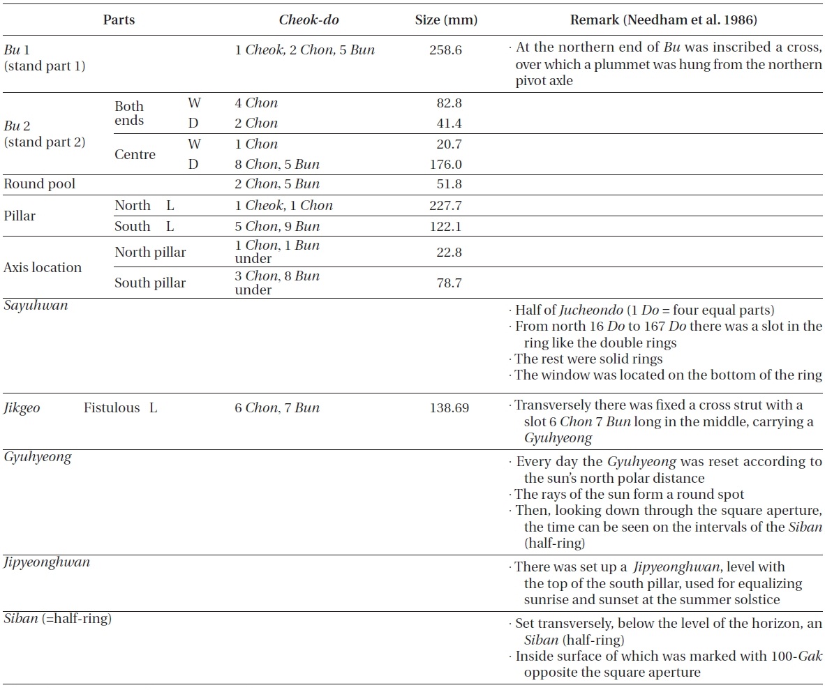
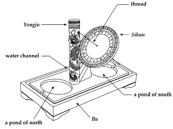
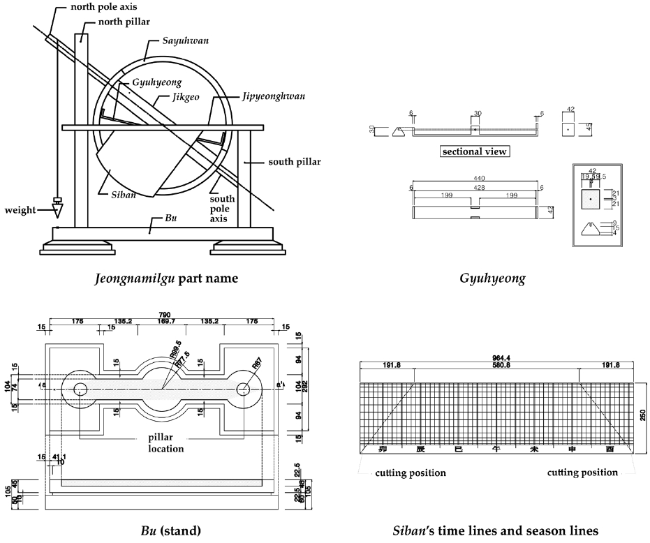
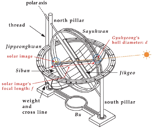
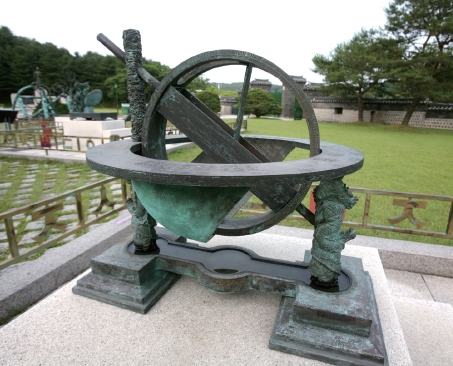
Jeongnamilgu, the sundial invented in 1437 (the 19 year of King Sejong era), has the features of an observation instrument. Table 2 shows the specifications of Jeongnamilgu presented in Sejongsillok. The name of each part, the scale at that time, the values converted to today’s unit, and the structure characteristics were described.
The Sayuhwan (four-displacement ring) axis that links the north-south pillar of Jeongnamilgu is to be aligned with the NP direction of the sky which is the rotational axis of the earth. Leveling was to be performed by hanging a weight with a thread at the tip of the Sayuhwan axis penetrating the northern pillar and aligning it with the cross lines. The Juchoendosu marks are engraved at both sides of Sayuhwan in order to measure Geogeukdo (the angular distance from the NP which is similar to the solar declination value) of the sun. The cross line method is the same with the leveling method of Hyeonjuilgu. The method to align the north-south direction was improved using Sayuhwan and Gyuhyeong.
Jikgeo is placed inside Sayuhwan and the Gyuhyeong inside it was to be moved so that the solar light could be received by Banhwan (half-ring). In the restoration model of the Korea Research Institute of Standards and Science, based on the research data of Needham et al. (1986), Banhwan was produced in the shape of an equator belt. However, Sejongsillok stated about Banhwan that it was installed under Jipyeonghwan according to the time of sunrise and sunset on the day of the summer solstice, which is different from the result of Needham et al. (1986).
The time of sunrise and sunset on the day of the summer solstice can give important information that determines the position and shape of Banhwan. The reference for Banhwan was set to the summer solstice, which may be actually the SE-AE line or the WE line with reference to the SS line. Thus, Banhwan of Jeongnamilgu is assumed to be a Siban with a round surface that expresses the position of the sun at 24 subdivisions of the seasons as in Angbuilgu, rather than a belt for the equator on the celestial sphere (Fig. 8).
Jeongnamilgu has the similar function with that of Angui in Chinese Yuan dynasty in the sense that the solar light spots are used. Despite the similar function, the measurement method is different: Angui has the light spot measurement function at the center, while Sayuhwan
of Honchonui was applied to Jeongnamilgu (Fig. 9).5 Jeongnamilgu has features of the Islamic sundials in that a hemispheric Banhwan was employed. This Islamic tradition led to Angui in Chinese Yuan dynasty and Angbuilgu in Joseon. Hence, Jeongnamilgu may be considered as a fusion sundial for observation in the structure of Angbuilgu that had the features of Islamic sundials.
The method to align the north-south direction in Jeongnamilgu is as follows: for the initial installment of Jeongnamilgu, the Gegeokdo value of the day should be known.6 After aligning the instrument according to the Gegeokdo value of the sun, the solar light spot should fall on the Sayuhwan face or Siban. For this, the instrument should maintain the leveling-off state. If the Sayuhwan surrounding Gyuhyeong is rotated, tuning the left and right sides of the Jeongnamilgu base, the moment when the solar light falls on the face occurs. At that moment, Jeongnamilgu is rightly aligned to the north-south direction.Then, the time can be measured by freely moving Gyuhyeong. The astronomical information including the sunrise time and sunset time at each subdivision of the seasons can be obtained using the seasonal subdivision lines.
In sundials, the shade of the needle falls on the Siban face. However, if the needle is long, the needle shade at the tip becomes faint and thus the mark cannot be read clearly with the shade. In the case of Jeongnamilgu, the solar light is introduced using the Gyuhyeong as shown in Fig. 8, not reading the shade. A tiny hole is made at the tip of the front side of the Gyuhyeong so that a bright image of the sun, which is the light spot, can fall on the Siban face on the basis of the pinhole camera’s principle.
The focal length (f) of a pinhole camera is the distance from the pinhole face to the focal plane. The depth of field is infinite. Generally, a more clearly image can be seen as the diameter of the pinhole is smaller. However, as the pinhole diameter is decreased, the image is seen darker. Hence, the image may be bright if the object is the sun, but the image may be faint by diffraction if the pinhole is too small.
The optimal pinhole diameter should be calculated after determining the focal length. The optimal pinhole diameter,which is determined by the diffraction pattern on the focal plane and light intensity of the solar light from the pinhole, is the distance from the center of the Airy disk to the first dark diffraction pattern. Based on this optimal pinhole diameter (d) condition, the following relation by Lee et al. (2006) assumed that the approximate mean solar wavelength observed by naked eyes is 5,500 A:
where the focal length (f) is the distance from the pinhole to the focal plane. Since the size of the restored Jeongnamilgu was three times larger than that of the actual one, the size of Gyuhyeong, 440 mm, corresponds to the focal distance and the optimal pinhole diameter (d) is 0.8 mm. The diameter of the solar image on the Siban face is calculated as in the following equation using the apparent diameter of the sun, 32 arcminute:
The diameter of the solar image, which is the light spot, is about 4.1 mm by Eq. (2).
5It seems that the shape of Gyuhyeong in Sayuhwan was an application of the Gyuhyeong in Honchonui that was widely used at that time. While the Gyuhyeong in Ganui has the structure that rotates at the side of Sayuhwan, the Gyuhyeong in Jeongnamilgu was described to move between a pair of Sayuhwan of Honchonui.
6If the accurate Gegeokdo value is not known, the north-south direction can be aligned by fine tuning using the approximate solar Gegeokdo value.
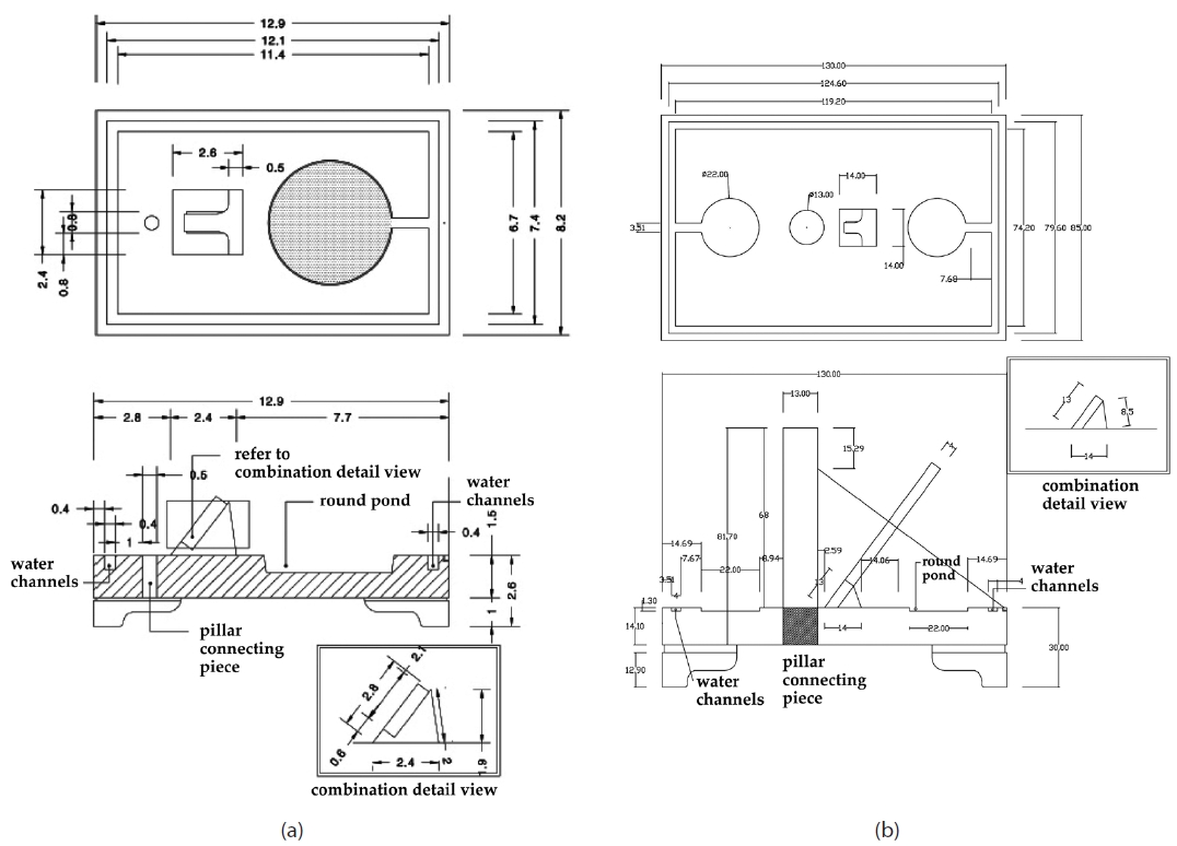
Because Hyeonjuilgu and Cheonpyeongilgu are the sundials that have an equator Siban, they do not have the function to measure the subdivisions of the seasons as in Angbuilgu. However, they are convenient, portable sundials in which the yearly variation of the solar meridian elevation and the daily variation of the solar hour angle are expressed as the shade on the Siban. We prepared the restoration design drawing for the fabrication of Hyeonjuilgu and Cheonpyeongilgu (Fig. 10; drawing: Korean Traditional Technology and Culture Co., Seoul, Korea). The design of Hyeonjuilgu was based on that of Ilyeongui, and Cheonpyeongilgu was designed referring to Hyeonjuilgu. The handle for Cheonpyeongilgu suggested in the main text was not included in the design and thus it has the structure to be put on a floor.7
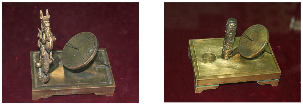
Fig. 11 shows the restoration models of Hyeonjuilgu and Cheonpyeongilgu produced according to the design
drawings (production: Korean Traditional Technology and Culture Co.). In Hyeonjuilgu, two dragons hold the supportive pillars, and a bead is hung on the thread that penetrates the mouths of the dragons for leveling of the instrument.8The pillar of Cheonpyeongilgu was built to be biased to the northern part from the center. The optimized position of the pillar was chosen, because Siban
would be too small if the pillar were located at the center.
In the newly restored Jeongnamilgu, the values that are observed by Angbuilgu can be measured in the same manner because it also has a round Siban just like that in Angbuilgu. The time and seasonal subdivisions can be measured and the sunrise and sunset times can be predicted in advance with Jeongnamilgu. The design
drawing for Jeongnamilgu was prepared by enlarging the size by three times for outdoor display (Fig. 12; drawing: Korean Traditional Technology and Culture Co.).9The Jeongnamilgu models produced in this way are exhibited at Yeongreung (the tomb of King Sejong) and the National Science Museum.
The Banhwan structure in Needham et al. (1986) was replaced by a round spherical surface applying the hour lines and the seasonal subdivision lines of Angbuilgu. This structure from the hemisphere shape of Angbuilgu provides the advantage to measure the time and seasons simultaneously. Twelve hours were marked under the Siban plane to read the time. The pillars with dragon patterns were used for the restoration of the northern and southern pillars because Jeongnamilgu is the instrument that was used by the royal family. The base was produced considering the stability of the instrument (Fig. 13; product: Korean Traditional Technology and Culture Co.).
7The schematic illustration of the handle attached to the bottom of Cheonpyeongilgu was provided in the main text. The restoration design and model did not reflect the presumption and just provided the basic model to be put on a palm or plane. We will provide the design and restoration model for Cheonpyeongilgu in further studies.
8The pillar in Hyeonjuilgu may be expressed with one pillar from the functional viewpoint, but two dragon pillars were built in the restoration model designing process so that a bead can be hung.
9It was produced as to be three times larger than the actual size for outdoor display. However, there is not a functional problem because the size was increased while understanding the working principle and structure of the original one. The only structural change was made while enlarging by three times for the base in order to install the instrument stably.
Among the sundials produced in King Sejong era, we analyzed two portable equatorial sundials and one sundial for observation that has Sayuhwan. The principle of the solar movement on the celestial sphere at the rate of 15°/1 hr (the hour in today’s concept) was applied to the equatorial portable sundials. This represents the solar movement at arbitrary latitude along the equatorial plane of the celestial sphere. The actual celestial move ment is by the rotation of the earth’s equatorial plane around the rotational axis one a day. Thus, the solar elevation may be varied between WS and SS, but the hour lines on the equatorial plane can be still used because the earth’s rotational axis is not changed. This indicates that the horizontal coordinates system sundials reflected the accurate understanding of the equatorial coordinate system in which the time can be read on any day despite the variation of the solar hour angle.
However, both sides of the Siban should be used since the solar meridian elevation is varied by the seasons with reference to the equatorial plane of the celestial sphere. In other words, the upper side of the Siban is read from the SE to the AE and the lower side from the AE to the SE of the next year. Cheonpyeongilgu might have a different shape from that of Hyeonjuilgu because it was used on horseback and had two round ponds. However, both Cheonpyeongilgu and Hyeonjuilgu did not have the function to measure the seasonal subdivisions, different from previous Angbuilgu and Jeongnamilgu. According to the investigation until now, the only East Asian country that produced a portable equatorial sundial was Joseon at that time. Regarding this, a more detailed investigation should be carried out about the artifacts of the surrounding countries.
Jeongnamilgu applied the method using Geogeukdo for the alignment of the north-south direction, different from the magnet-based method in the previous equatorial sundials. The time of the solar meridian elevation is changed every day. If Geogeukdo of the measurement day is known, the north-south direction was aligned by moving Gyuhyeong so that the solar light spot can fall on the Sayuhwan face (or Siban face). Such direct observation of the solar spot in sundials was also applied in Angui of China; the method of Joseon that employs Sayuhwan is basically different in the structure from the Chinese method that uses the tip of a needle.
As a round Siban of Angbuilgu was adopted for the restoration model of Jeongnamilgu, the variation of the solar Geogeukdo and the seasons could be easily measured after the initial installation of Jeongnamilgu. The tradition of spherical surface may be associated with the technological development from the Islamic tradition, to Angui of Yuan dynasty and Angbuilgu of Joseon. The measurement of the seasonal subdivisions using a spherical surface was possible only by the accumulated astronomical knowledge that enabled to express the theoretical principle of the astronomy at that time to the observation instruments.
We prepared the design drawings of Hyeonjuilgu, Cheonpyeongilgu and Jeongnamilgu by studying the structure, method to use, principle and produced the restoration models. We hope that the sundials could be restored more stably in the future by improving the models through continued experiment with them.
100-Gak Siban 百刻時盤, round plate with one hundred intervals time lines
Angbuilgu 仰釜日晷, hemispherical sundial
Angui 仰儀, upward hemisphere
Baekgakhwan 百刻環, one hundred intervals time lines ring
Banhwan 半環, half-ring
Bu 趺, stand; base
Cheonpyeongilgu 天平日晷, portable equatorial sundial
Cho 初, beginnings double hours
Chou-Cheok 周尺, scale unit (1 Chou-Cheok = 207 mm, 1 Chon = 20.7 mm, 1 Bun = 2.07 mm)
Ganui 簡儀, simplified armillary sphere
Geogeukdo 去極度, the angular distance from the north pole which is similar to the solar declination value
Gyuhyeong 窺衡, sighting alidade
Gyupyo 圭表, gnomon
Honui 渾儀, armillary sphere; also called Honcheonui 渾天儀
Hyeonjuilgu 懸珠日晷, portable equatorial sundial; plummet sundial
Ilseongjeongsiui 日星定時儀, sun-and-star time determining instrument
Ilyeongui 日影儀, portable equatorial sundial
Jagyeongnu 自擊漏, striking clepsydra
Jeong 正, mid-points double hours
Jeongnamilgu 定南日晷, south-fixing sundial
Jikgeo 直距
Jipyeonghwan 地平環, horizontal ring
Jucheondosu周天度數, 365.25度
Sayuhwan 四游環, four-displacements ring
Sejong 世宗, King Sejong (1418~1450) of Joseon
Sejongsillok 世宗實錄, Annals of Sejong
Siban 時盤, round plate with time lines
Sigan 時間, corresponding to two hours at present
Soganui 小簡儀, small size simplified armillary sphere