Environmental change is a continuous process that is well recorded in only a few ecosystems. Among these are high moors (bogs), which are remarkable archives of long-term natural changes, because they document vegetation history within peat that accumulates almost continuously over several millennia (Charman 2002,Robichaud and Begin 2009). The development of bogs is influenced in a complex combination by autogenic processes (peat build-up) and allogenic forces such as climate, disturbances, and topography (Tolonen 1987,Korhola 1992, Kuhry et al. 1993, Charman 2002).
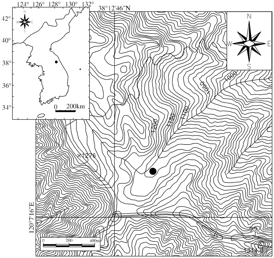
Yongneup moor is developing at the northwestern slope of Mt. Daeamsan (1,304 m) at the boundary between Inje-gun county and Yanggu-gun county, Gangwon-do province, Korea. Yongneup was first classified as a high moor (German classification) or a raised bog(England classification) by the demilitarized zone (DMZ)survey team in 1967, and, thereafter, much attention has been paid to the Yongneup moor because it is a unique raised bog in Korea (Kang et al. 2010).
Pollen analysis is the principal technique used to document and reconstruct past vegetation and environments of the local region around raised bogs (Birks and Birks 1980). Since Yamazaki (1940) reported the first pollen analysis of Saeseok Pyeongjeon (a wet grassland) at Mt. Jirisan located in the southern part of Korea, a period followed of over 30 years in which pollen analysis studies and reconstructions of vegetation history were not conducted in Korea. By the end of the 1970s, studies using accurate 14C-dating were conducted on sediments in the east-central lowlands and the sub-mountain areas including Lake Youngrangho on the Korean peninsula (Jo 1979, Yasuda et al. 1978, Yoon 1998, Fujiki and Yasuda 2004, Park 2005).
However, studies on changes in past vegetation obtained from mountainous or subalpine wetland sediments were not performed except for those at Yongneup moor, which developed in the mountainous area of the east-central inland of the Korean peninsula. Therefore, it was assumed that Yongneup bog would be a suitable site to reconstruct the development and changes in past local vegetation. Previous pollen analytical studies on this moor (Kang 1980, Chang et al. 1987) were limited in reconstructing past vegetation changes, because their radiocarbon dating results were insufficient and they collected a small number of peat samples.
In the present study, we attempted to reconstruct changes in the local vegetation of the mountainous area of the central Korean peninsula using pollen analysis in parallel with radiocarbon dating of a number of samples collected from the peat sediments of Yongneup moor known as a unique high moor (raised bog) in Korea. The results obtained from this study will provide information for understanding the past local vegetation around Mt. Daeamsan.
Yongneup moor is a depressive wetland with an area of 7,490 m2 on the northwestern slope of Mt. Daeamsan (Fig. 1). The surrounding area (1.06 km2), including Yongneup, was first designated as an Ecosystem Conservation Area in 1989 but an expanded area of 1.36 km2, including two other nearby wetlands, were considered an Ecosystem Conservation Area in 2010.
Furthermore, the Yongneup moor itself was registered as a Ramsar Convention Wetland on March 28, 1997 for the first time in Korea and Yongneup was designated as a Wetland Conservation Area in 1999. Additionally, nearby mountains such as Mt. Dosolsan (1,478 m), Daewoosan (1,179 m), Baekseoksan (1,142 m), and Samyeongsan
(1,198 m) including Mt. Daeamsan were designated as Nature Reserves in 1973.
>
Vegetation around Yongneup moor
Actual vegetation on the mountains around Yongneup moor is composed of deciduous broad-leaved forest dominated by
In contrast,
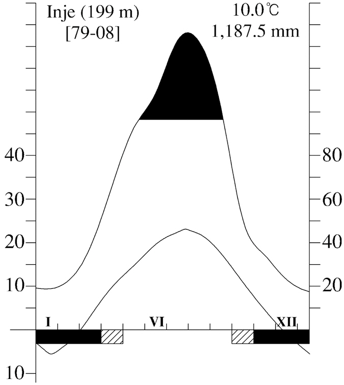
To understand the climatic characteristics around Yongneup moor, we constructed a climate-diagram (Walter et al. 1975) using meteorological information measured at Inje Meteorological Station during the 30 years from 1979-2008 (Fig. 2).
The average temperature was 10.0°C and annual precipitation was 1,187.5 mm. The mean temperature in August (warmest month) is 23.2°C and that in January (coldest month) is -5.1°C. Approximately 60% of all precipitation occurs from June to August. A period of greater than 100 mm of monthly precipitation occurs for 4 months from June to September. Such a precipitation pattern is similar to other regions on the Korean peninsula. In particular, a severe dry month, limiting plant growth, does not occur at Yongneup moor.
>
Pollen analysis and radiocarbon dating
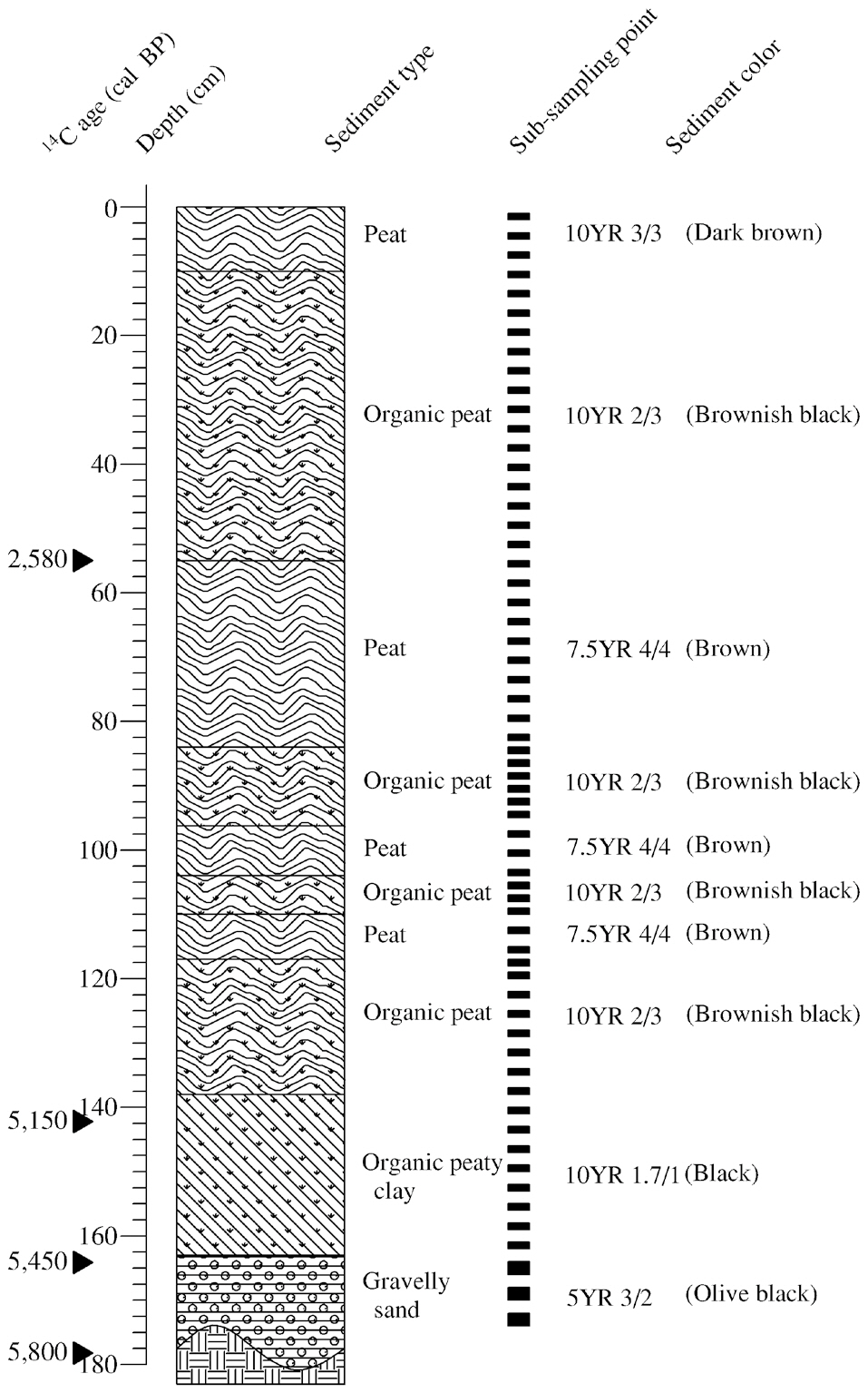
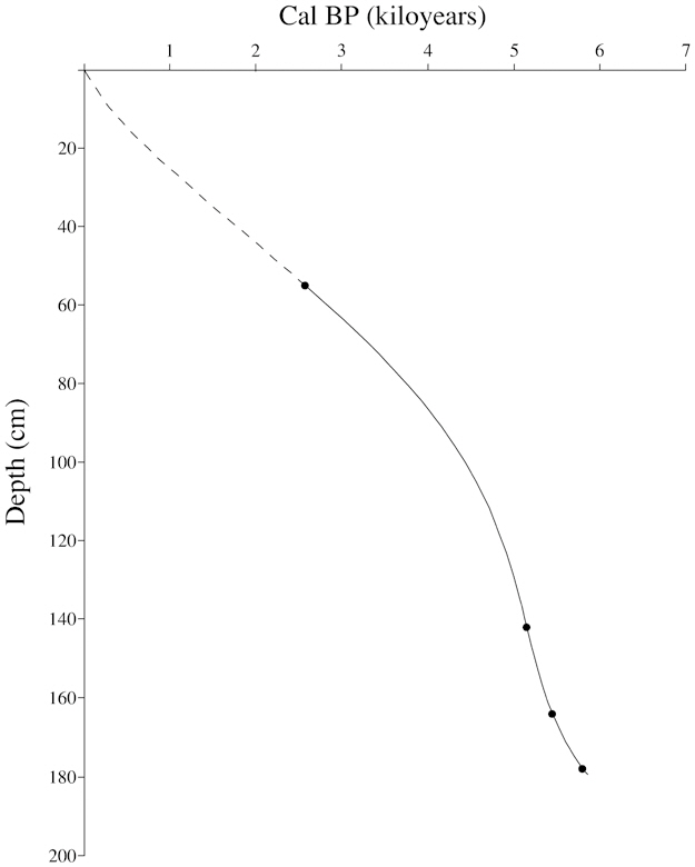
A pollen analysis is a tool to reconstruct vegetation history from a particular location over time. Sediment sample cores for the present study were collected using a Hiller type peat-borer at 38°12′57.4″ N, 120°7′30.2″ E (Fig. 1). As shown in Fig. 3 and Table 1, five successive samples for 14C-dating were obtained from the bottom, at a depth of 180 cm, to the surface and were transported to the AMS facility at Seoul National University. Radiocarbon years were converted to calendar years using the CalPal program available online (Danzeglocke et al. 2008). The 61 sediment samples for pollen analysis were also sub-sampled in parallel with a description of sediment properties using revised soil color charts (Oyama and Takehara 1997).
Standard procedures, including 10% KOH treatment, heavy-liquid separation with ZnCl2 (specific gravity 1.68-1.70), and subsequent acetolysis (Erdtman 1943, 1960, Fægri and Iversen, 1989) were used to extract pollen from the sediment samples. Pollen and spores mounted in glycerin jelly were counted under a light microscope at magnifications of ×400-1,000.
Identification of pollen and spores was aided using previously published studies (Wodehouse 1935, Erdtman 1986, Fægri and Iversen 1989) and by comparing the pollen and spores to reference pollen samples collected and treated at the University of Ulsan. More than 300 pollen grains and spores were counted based on the amount of arboreal pollen (AP) per slide. A pollen diagram was created using relative pollen frequency (RPF) based on the AP.
Identified pollen and spores were classified into AP (trees) and non-arboreal pollen (NAP, shrubs, herbs, and spores). The scientific names used are the families or genera of the pollen corresponding to the plant.
AP was as follows:
NAP was as follows:
>
Physical characteristics of sediment
The vertical facies of the sediment core collected from the Yongneup moor are presented in Fig. 3. Of the entire 180 cm, the upper layer from a depth of 138 cm to the surface was mainly composed of peat or organic peat.
The layer between 180-163 cm was gravelly sand containing some clay, and the color of these layers was olive black due to the small quantity of organic matter. The layer between 163-138 cm was organic peaty clay containing indistinguishable organic remains and distinguishable plant debris with the naked eye. The color of these layers was black. The layer between 138-10 cm alternated repeatedly with brownish and humified peat, indicating the relative difference in the humification of peat. The layer from 10 cm to the surface was composed of dark brown peat, suggesting that this upper layer was affected and disturbed by the peat sampling procedure because of its high water content.
From the physical features described above, soil components from the vicinity of the slope at Yongneup moor did not flow from the 138 cm depth layer to the surface. Accordingly, it was inferred that the peat sediment of
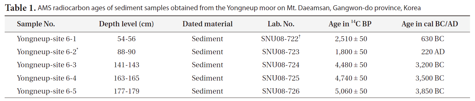
AMS radiocarbon ages of sediment samples obtained from the Yongneup moor on Mt. Daeamsan Gangwon-do province Korea
these upper layers was only composed of autochthonous plant remains, including air-born pollen and spores, as well as allochthonous dust and aerial deposition.
It was confirmed by 14C-dating that the Yongneup moor was initiated by the formation of a concave wetland approximately 5,900 calibrated years (cal) before present (BP) (Table 1). An age-depth curve was plotted in Fig. 4 to estimate the sediment ages using the 14C-dating results.
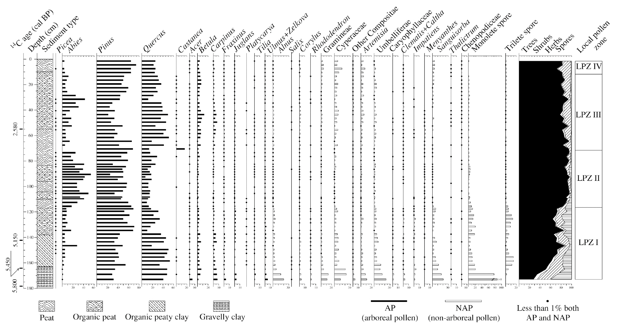
To facilitate discussion of the pollen record, the pollen diagram was subdivided into four local pollen zones (LPZ) based on the percentage of the principal pollen and spores (Fig. 5)
LPZ-I (Quercus-Pinus zone)
The pollen spectra during the period 5,900-4,800 cal BP (lower sediment) were characterized by high percentages of
Pollen of the shrubby
LPZ-II (Pinus-Abies-Quercus zone)
The LPZ-II zone was estimated to be 4,800-3,400 cal BP and was characterized by rapid increases in
Compared with the pollen frequency in the LPZ-I zone,
LPZ-III (Quercus-Pinus-Abies zone)
The LPZ-III zone was estimated to be 3,400-390 cal BP. The vegetation information on the LPZ-III zone was obtained from the 72-12 cm depth sediment layer. The LPZ-III zone was characterized by an increase in
LPZ-IV (Pinus-Quercus zone)
The LPZ-IV zone was estimated to be 390-present cal BP was the uppermost zone including sediment at depths of 12-0 cm. This zone was characterized by rapid increases in
From the 14C-dating results, the bottom sediments began to form in the Yongneup moor approximately 5,900 cal BP. The successive pollen spectra in Yongneup moor sediment provided information for reconstructing the changes in past vegetation on local and regional scales in the mid-late Holocene. The Korean peninsula vegetation types for reconstructing past vegetation were based on Yim and Kira (1975), Yim (1977a, 1977b), and Kim (1992). Decisions about past vegetation based on the pollen assemblages were based on Choi (1997, 1998) and Song (2002). Chang et al. (1987) has conducted analytical pollen studies on this moor, but they did not perform radiocarbon dating. Furthermore, their RPF calculation method differed from that used in the present study. Therefore, we compared our relative similarities with those of the main AP RPFs, as a direct comparison to their results was difficult.
According to the pollen assemblage spectra in the LPZ-I zone, which occurred 5,900-4,800 cal BP, it was inferred that past vegetation along the foot to the slope of Mt. Daeamsan was composed predominantly of
The
Considering the variations in fossil pollen and spores during LPZ-II (4,800-3,400 cal BP), it is estimated that subalpine coniferous forest developed at the outskirts of Yongneup moor and along the ridge to the summit of Mt. Daeamsan. This indicates that the subalpine coniferous forest, composed of
The high percentages of subalpine pollen taxa in the LPZ-II occurred because the subalpine coniferous forest, such as
During the period from 3,400-390 cal BP (LPZ-III),
The reconstructed vegetation types of this period nearly coincided with those of LPZ-I. However, the percentages of
In LPZ IV (390-present cal BP), the most conspicuous pollen frequency feature was a sharp increase in
Based on the pollen composition, the vegetation type surrounding Mt. Daeamsan during LPZ IV was probably cool temperate central/montane mixed deciduous broad-leaved and coniferous forest. The abrupt increase in
A pollen analysis and radiocarbon dating of sediment peat collected from Yongneup moor were conducted to reconstruct past vegetation in the mountainous region of the central Korean peninsula during the Holocene. The 61 pollen analysis samples and the five 14C-dating samples were obtained from depths of 180 cm to the surface. Of the samples collected, the sediments from depths of 130 cm to the surface were sequential peat.
The year of the bottom sediment was approximately 5,900 cal BP. Four LPZs were identified from the pollen analysis results at Yongneup moor. The past vegetation inferred from the pollen record included: (1) cool temperate central/montane deciduous broad-leaved forest (LPZ-I) during the period from 5,900-4,800 cal BP, (2) cool temperate northern/alti-montane mixed coniferous and deciduous broad-leaved forest (LPZ-II) during the period from 4,800-3,400 cal BP, (3) cool temperate central/montane deciduous broad-leaved forest (LPZ-III) during the period of 3,400-390 cal BP and (4) cool temperate central/montane mixed deciduous broad-leaved and coniferous forest (LPZ-IV) during the period from 390-present cal BP. These pollen zones represent the vegetation dynamics at the different levels and reveal several original features of the areas around Yongneup bog and Mt. Daeamsan since the Holocene.
Although the pollen analysis technique is useful to reconstruct past vegetation, it should be applied in parallel with 14C-dated sequences of other subalpine wetlands such as bogs and fens to elucidate past vegetation on the Korean peninsula. Additionally, insufficient data are available, except for Yongneup bog, so further efforts should be made to conduct additional palynological analyses.