Islands are often habitats to unique species because they have different environmental conditions from the mainland and other islands. Another characteristic of islands is their limited natural resources, which has led island residents to heavily rely on traditional ecological knowledge (TEK) and use resources sustainably. The so-called “Maeul landscape” shows the interrelationship of biological species and people’s use of natural resources. Shinan-gun is an administrative district located in the southwestern part of Korea that forms an archipelago with huge tidal flat areas. Since long ago, people’s use of these tidal flats shows a high degree of biocultural diversity. Maeul landscapes also show humans’ adaptation to the natural environment. For instance, strong winds blowing mainly from the northwest have led people in Shinan-gun to create “Ushil,” a windbreak forest with stone blocks to block wind from their villages and agricultural fields. At present, the transfer of TEK to future generations is at stake due to socio-economic changes that cause island populations to shrink and age rapidly. Islands are often regarded as good destinations for tourism, but attention should also be given to sustainable development due to the environmental characteristics of islands. International organizations are making efforts to curb the threats of global environmental problems especially on small islands. Their activities are aimed at seeking solutions that stress the central role of biocultural diversity in establishing the sustainable use of natural resources on islands. Joint efforts oflocal people and government authorities to protect and conserve the Maeul landscape should be encouraged.
In the past, islands have been strongly associated with being isolated. This geographic feature of islands plays an important role in showing the biogeographic characteristic of islands (Kim and Hong 2007). In island biogeography, it is said that the size and diversity of species are related to how far away an island is from the mainland, and how large it is (MacArthur and Wilson 1967, 2001). Being separated from the mainland is the elemental characteristic of islands, and it is obvious that this “separateness” influences people inhabiting the islands.
Currently, it is known that 10% of the 7 billion people on earth are living on islands (UNFPA 2014). Due to isolation from the mainland over a long period of time, islanders often lead their own unique lives The knowledge they gather and pass on from generation to generation about their coexistence with nature is called traditional ecological knowledge (TEK) (Hong 2011). Due to the large variation in the natural environment of islands, people have adapted to nature in different ways, and various island cultures have evolved (Hong and Kim 2011a, Hong 2012).
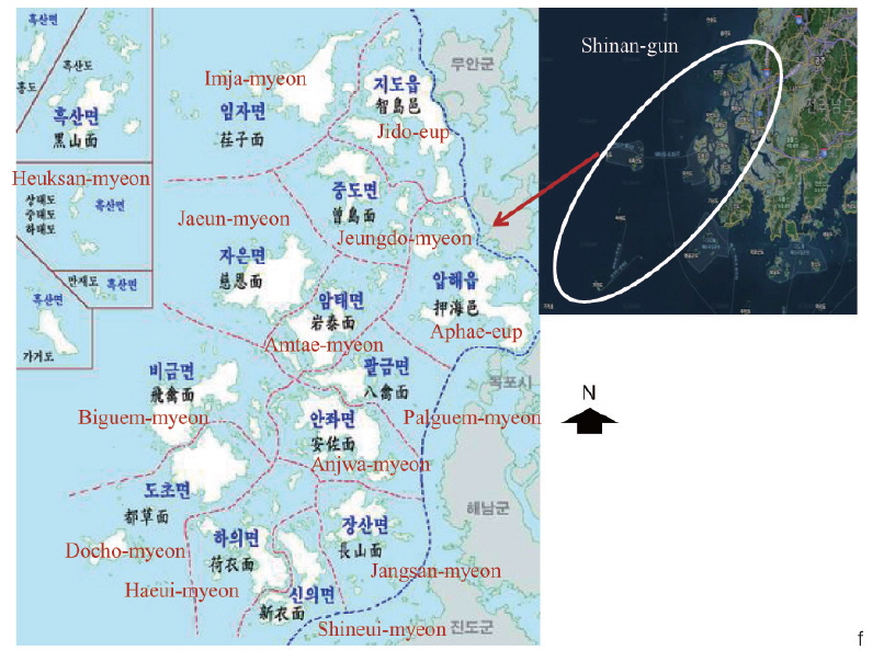
Differences in various features can be seen on many islands of Shinan-gun
>
Rural landscape in Korea and Satoyama in Japan
The concept of Maeulsup (Korean for “village groves”) has received much attention since the late 1980s and early 1990s in Korea. This concept generally refers to rural landscapes, and it shares great similarities with the concept known as “Satoyama” in Japan.
In Japan, Satoyama had begun to receive attention because forests around villages were not being utilized anymore, as a result of the country’s fuel revolution accompanying rapid economic growth between the 1960s and 1970s (Kim et al. 2006). Tree branches and leaves collected from mountains for fuel were replaced by gas or oil, and massive urbanization led to a reduction of the workforce in rural areas. This caused a dramatic decrease in the use of Satoyama in Japan (Takeuchi et al. 2003, Kim et al. 2007, Kim et al. 2014).
The socio-economic changes had directly influenced forests around villages. People’s interaction with the forests over a long period of time had enabled forests to provide diverse habitats. In fact, according to Foley et al. (2005), the interaction of people and forests in such seminatural environment provides more variety in ecological services. People have consistently interacted with rural landscapes over the years (Lee et al. 2007, Kim et al. 2014). Human activities such as collecting tree branches and leaves by cutting or raking them have a strong influence on the environment of habitats for herbaceous plants. Cutting branches or raking fallen leaves enables sunlight to reach to the ground and help plants germinate (sprout) and grow well (Takeuchi et al. 2003, Kim et al. 2006, Kim et al. 2007).
But, social changes and economic development have left the forests unmanaged. Forests that lost their interaction with people became filled with other species due to dense tree branch growth and (ecological) succession, affecting the growth and diversity of herbaceous plants and shrubs. Along with the socio-economic changes and their effects on the forests, people had also gradually started to miss the landscapes of the past and they developed a desire to enjoy such landscapes.
In Korea, rural landscape studies had become an active field of research in the early 1990s. Various definitions of Maeulsup are currently being used in Korea. Most notably, in 2005, the Cultural Heritage Department defined and distinguished different types of forests as well as Maeulsup (Cultural Heritage Administration of Korea 2005).
However, after summarizing most of the developed concepts about Maeulsup, it can be said that rural landscapes are representations of unique cultural landscapes that has emerged as a result of consistent interaction between men and nature over a long period of time (Choi and Kim 2009, Hong and Kim 2011b).
In Table 1, various definitions regarding Maeulsup are listed (Kim and Jang 2005, Park 2006, Park 2007, Choi and Kim 2009), but since the word “-sup (forest)” has limitations to fully express the full scope of Maeulsup, the use of “rural landscape” is considered more appropriate than “Maeulsup.” This is because the word “Maeulsup (village forest)” suggests a rather specific meaning that does not cover other ecosystems, it only shows the relationship between villages and forest ecologies. The word “rural landscape,” on the other hand, allows for a broader meaning that fully captures the diversity in village surroundings, as can be seen in reality. Moreover, the division of rural landscape into aspects of functions and contents have shown various overlapping functions. Also, some rural landscapes have been considered to have no aspects in terms of functions and contents. Therefore, in order to omit the complications that come with categorization based on contents and functions, it seems more appropriate to use the term “rural landscape” to group all concepts regarding villages and surrounding environments.
[Table 1.] List of Maeul forests according to type (transformed by Hong et al. 2010)
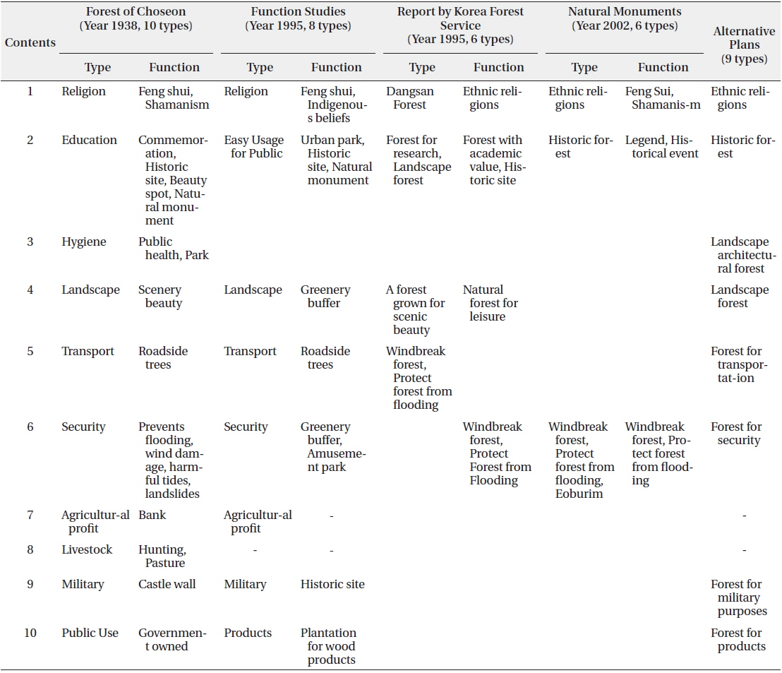
List of Maeul forests according to type (transformed by Hong et al. 2010)
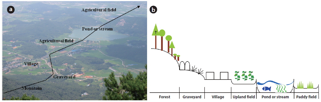
Rural landscape refers to the whole landscape including human settlements, which means villages and their landscapes, which consist of various ecological elements such as agricultural fields, rivers, ponds, etc. (Fig. 1). In particular, this concept will be more appropriate in the case of small islands. Except for several big islands that include Jeju Island, Korea mostly consists of small islands of which the majority is located along the western and southern coasts ofJeollanam-do. In the case of these small islands, an island in itself can be referred to as a rural landscape.
>
Case study of Shinan-gun, Jeollanam-do
Shinan-gun includes a UNESCO (United Nations Educational, Scientific and Cultural Organization) Biosphere Reserve, a national park, and a marine protected area near the Gageodo Islands (Fig 2). It is noteworthy that nearly 75% of the 452 species of migrating birds crossing the Korean peninsula can be seen in Shinan-gun (Hong et al. 2013). In particular, the region plays an important role as a pathway for migrating birds that are designated as endangered species by the Korean Ministry of Environment as well as international authorities (Hong et al. 2013, Hong 2011). A number of islands located throughout this area are used as shelters or habitats by various birds and creatures, and have beautiful and spectacular views of the coast, which has been shaped by erosion due to waves and winds (Hong 2011).
Sub-tropical forests are well developed in this region, and it has been confirmed that South Korea’s largest colonies of
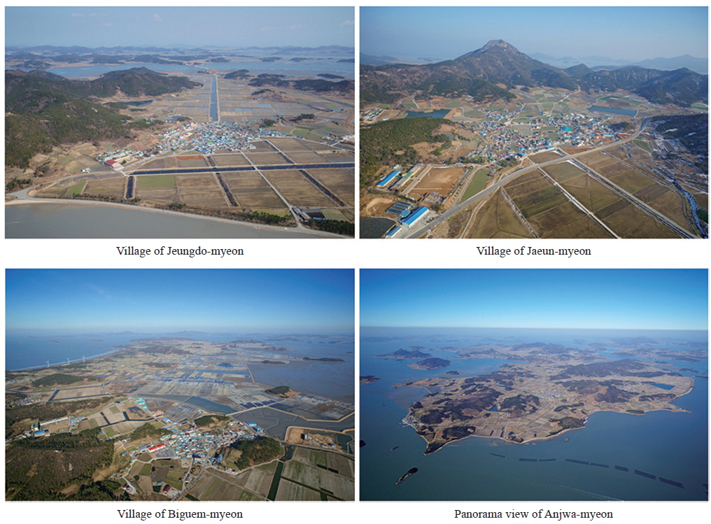
The tidal flats are well developed in Shinan-gun. The active reclamation of the wide tidal flats had started from the late Joseon Dynasty and continued throughout the Japanese colonial rule until the 1980s (Mun and Park 2003). On islands where people had lived with limited resources, it was difficult to get rice, the principal food for Koreans. Therefore, with the reclamation of mud flats, islanders were able to have wider rice fields and several islands were combined into bigger islands (Mun and Park 2003). Except for Heuksan-myeon, Shinan-gun would best be called an agricultural area since farming is more developed than fishing (Kim 2014). Therefore, wide farming fields can be seen in most of Shinan-gun like other inland farming areas (Fig. 3).
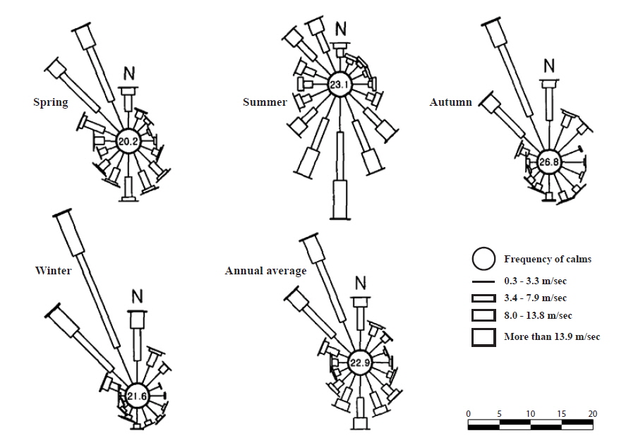
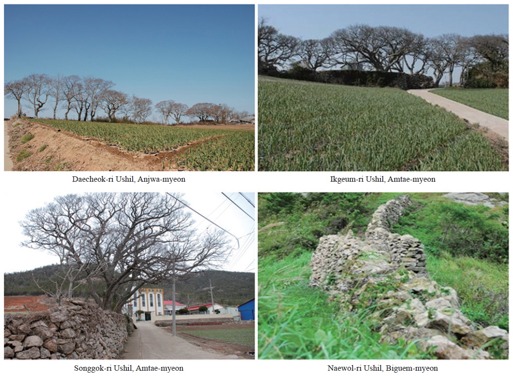
Due to the geographic characteristics of the region, Shinan-gun experiences mainly northwesterly winds in all seasons except summer, and in winter. These winds blow strongly from Siberia (Fig. 4). Efforts to create shelter to safeguard from these winds can be seen throughout the island (Fig. 5). As methods to protect island settlements from the winds, stone walls were built, and forests were grown in long horizontal lines using mainly
>
International efforts to protect biocultural diversity
In Shinan-gun, a variety of species live in the wide mud flat areas: with small octopuses, clams, crabs, and seaweed abound, along with a wide range of high biodiversity of fish in the sea (Hong et al. 2010, Koh 2001). Given these rich resources, there is a wide range of traditional ecological knowledge about utilizing them (Hong 2012, Hong 2014). Based on these facts, the Shinan-gun archipelago was designated as a UNESCO Biosphere Reserve in May 2009 (Lee et al. 2010).
It is well known that unique and rare creatures that are difficult to see in other areas abound on islands. More than 90% of the species living on the Hawaiian Islands and more than 50% of the mammals, birds, amphibians, reptiles, and higher plant life living on small islands of the French Mauritius Islands in the west end of the Indian Ocean are known to be rare species (Hong 2014).
Because of their geographical characteristics, islands have been isolated for a long time. For this reason, there are species that have adapted exclusively to the environments of islands. Along with this, traditional ecological knowledge on how to take advantage of a variety of such species has emerged (Kim and Hong 2007). In present Korea, the population of islands is consistently decreasing, and this is most evident in younger age groups (Park et al. 2013). The disconnection it causes between older and younger generations means that the succession of traditional ecological knowledge to successive generations is at stake (Kim 2013, Kim 2014).
The United Nations designated 2014 as the “International Year of Small Island Developing States (SIDS),” and the theme of the “International Day for Biological Diversity 2014” was island diversity These actions are signs for us to realize that the future of the western islands of Korea is not bright, even more so due to the rise in sea level and ocean temperature caused by the rapidly changing global climate worldwide.
Along with drawing worldwide attention to these situations, the Commission on Environmental, Economic, and Social Policy (CEESP) of the International Union for Conservation of Nature (IUCN) is pursuing a variety of projects based on the linkages and interaction between biodiversity and cultural diversity. At the 5th World Conservation Congress (WCC), held in Jeju Island in 2012, the sustainable preservation of biodiversity and use of cultural resources in ecosystems on islands and other coastal areas vulnerable to climate change were discussed, and an initiative entitled “Proliferation of bio-cultural diversity through preservation of traditional ecological knowledge around Asian-Pacific Islands and coastal areas” has been proposed and passed (IUCN http://www.iucn.org/). The purpose of this initiative is to spread biocultural diversity by overcoming various problems faced by islands and coastal areas, and preserve and pass down traditional ecological knowledge, so that biodiversity and cultural diversity can be developed harmoniously with one another. The resolution was adopted as the “IUCN Resolution 5.115” in the IUCN, attracting worldwide attention and concern.
Shinan-gun, located in the southwestern part of Korea, and consisting only of islands, is a municipality with the largest number of islands and the largest area of mud flats in Korea. Due to these characteristics, a high level of biodiversity and traditional ecological knowledge for using various resources co-exist in the area (Hong 2012, Kim 2013). It was also for this reason that this area was designated as a “UNESCO Archipelago Biosphere Reserve” by UNESCO in 2009 (Lee et al. 2010).
However, the current demographic problems of a shrinking population and aging may lead to the discontinuation of handing down traditional ecological knowledge about sustainable use of limited resources. In the past, people living on islands were trying to protect Ushil, an element of the rural landscape of Shinan-gun, but now municipalities need to protect it. In addition, in the past, “Nodoo
Eventually, the loss of the geographical identity of islands is almost certainly going to impact the traditional ecological knowledge about how to sustainably utilize a variety of species and resources. Therefore, projects to connect islands to the mainland should be assessed more critically than what is currently being done, by taking into account these fundamental issues.
Activities for international cooperation are actively being pursued to solve fundamental environmental problems such as sea level rise and climate change. Particularly, efforts are being made to preserve and utilize a variety of unique species native to the islands.. A variety of efforts should be made to preserve and take advantage of rural landscapes in sustainable ways. To prevent rural landscapes from being undermined, it is necessary to obtain the cooperation of islanders. There is a need to promote the self-esteem of inhabitants of islands by enhancing the local image and changing existing negative views about islands.
Rural landscapes have been built through the interaction between nature and human beings over a long period of time. Various measures to preserve and protect rural landscapes from a variety of development pressures need to be discussed.