This study was conducted in an effort to provide important clues pertaining to the conservation and restoration of Aporia crataegi by identifying the spatial distribution characteristics of the current habitats, prospective habitats, and future habitats of A. crataegi in accordance with climate changes. To determine the distribution of A. crataegi, data from a total of 36 collecting points throughout South Korea, North Korea, China, Japan, Mongolia, and Russia are used. The spatial distributions of the data were examined through MaxEnt modeling. The distribution probability rates exceeded 75% at 18 locations among the 36 species occurrence locations, with Gangwon province showing the highest distribution probability in South Korea. The precision of the MaxEnt model was remarkably high, with an AUC value of 0.982. The variables that affect the potential distribution of A. crataegi by more than 10% are the degree of temperature seasonality, the amount of precipitation in the warmest quarter, the annual mean temperature, and the amount of precipitation in the driest month, in that order of importance. It was found that the future potential distribution area of A. crataegi continuously moves northward over time up to 2070s. In addition, the area of the potential distribution showing a habitable probability rate that exceeds 75% in northeast Asia was 28,492 km2, where the area of potential distribution in the north part of Korean peninsula was 20.404 km2 in size. Thus, it is anticipated that the most important future habitats of A. crataegi in the northeast Asia will be North and South Hamgyeong provinces and Ryanggang province near Mt. Baekdoosan in the northern area of the Korean peninsula.
The annual mean temperature of Korea during the past century has increased by 1.7°C, which is significantly higher than the change in the global mean (0.74 ± 0.03°C). In addition, annual mean temperature is expected to rise at least another 2°C by 2050 (Korea Adaptation Center for Climate Change 2015), implying that
Thus, the purpose of this study is to provide important clues with regard to the preservation and restoration of
Samples of
[Table 1.] Geographical information of Aporia crataegi in the northeast Asia
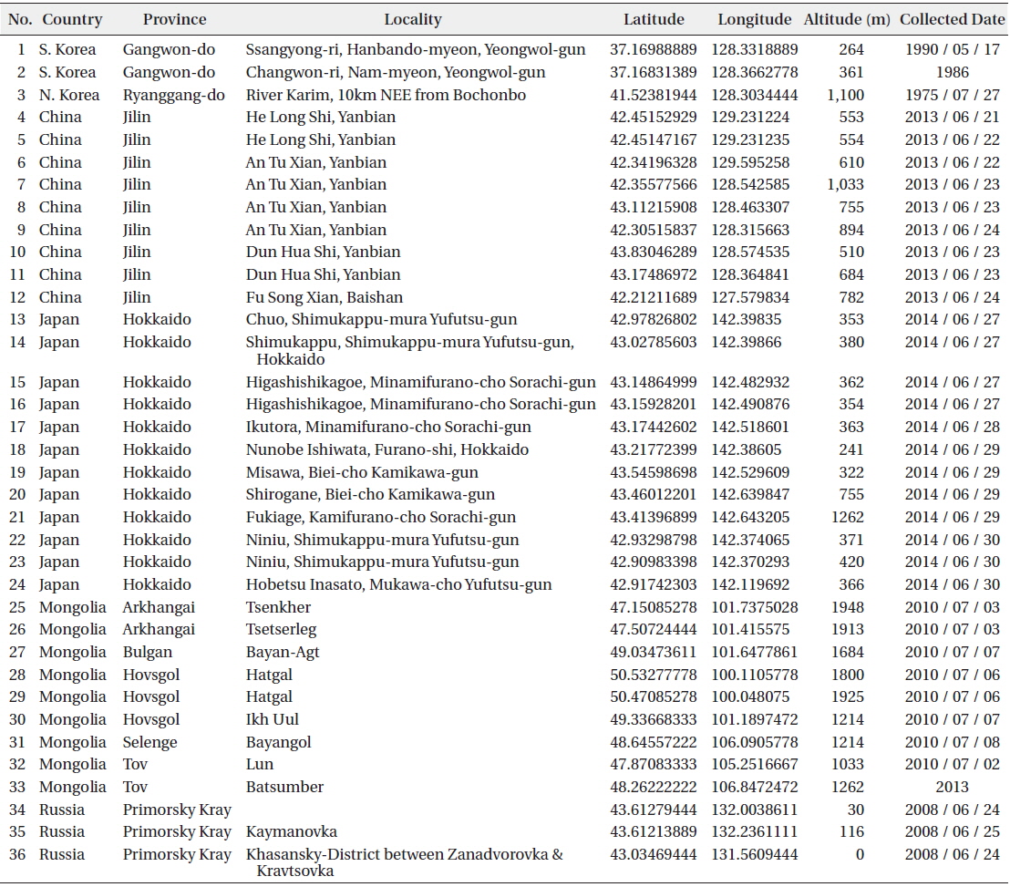
Geographical information of Aporia crataegi in the northeast Asia
It is necessary to incorporate current and future climate data to predict and assess the change in the distribution of
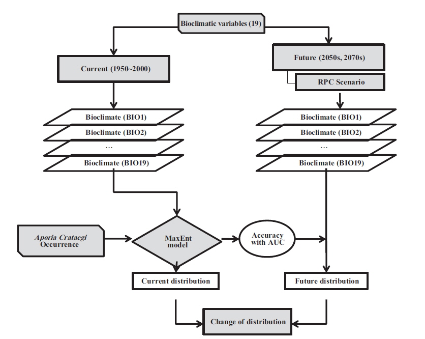
The HadGEM-AO model data, from one of the many models of CIMP5, which use the Representative Concentration Pathway (RCP), as determined by the IPCC’s Fifth Assessment Report on the 2050s (2040-2060) and the 2070s (2060-2080), was used as the climate scenario to predict the future distribution of
To apply the data to the MaxEnt species distribution model, bioclimatic variables, which were converted to add more biological significance to the monthly mean temperatures and precipitations (Table 2), were used. These variables have been used often in a range of studies that attempt to predict the potential habitats of biological species through ecological niche models. These variables represent climate extremes such as annual tendencies of the annual mean temperature and the annual precipitation, the seasonality of annual ranges such as the annual mean temperature and the annual precipitation ranges, the mean temperatures of the coldest and the warmest months, and the temperatures of the driest and the most humid seasons by quarter.
[Table 2.] List of bioclimatic variables used in the modeling
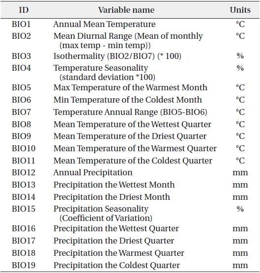
List of bioclimatic variables used in the modeling
MaxEnt modeling algorithms were used to predict the changes in the geographical distribution of the
In order to predict changes in the habitable zones of
The model’s explanatory power was validated by using the area under the curve of the receiver operating characteristic (ROC). Jackknife validation was used to validate the importance of the climatic variables which affect the potential habitats predicted as a result of the model simulation (Phillips et al. 2006). The programs used for the analysis of the distribution changes were MaxEnt ver. 3.3.3k (Phillips et al. 2006) and ArcGIS ver. 10.0 (ESRI 2011). Additionally, R-3.1.1 (http://www.R-project.org/) was used for the statistical analysis.
>
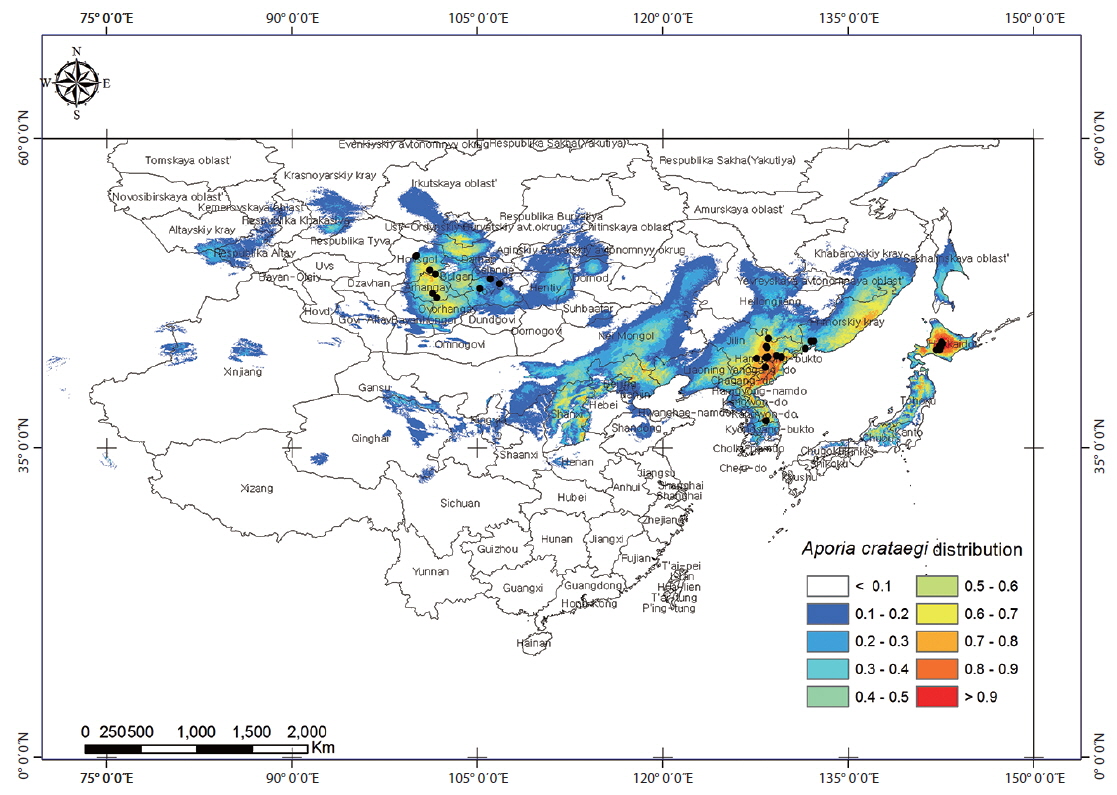
Prediction of the current potential distribution zone of Aporia crataegi
Current potential distribution zone of Aporia crataegi
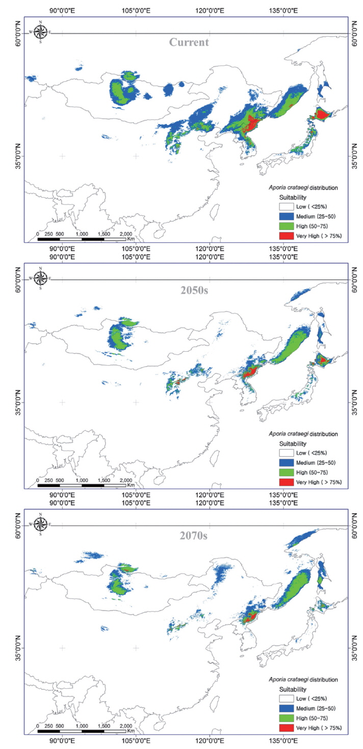
The results, obtained through a prediction method with 19 bioclimatic variables applied to the MaxEnt model, showed that 18 of the 36 presence locations had a probability above 75%; 26 locations showed a rate that was 50% or higher and 32 locations had a rate that was 25% or higher (Fig. 2). In South Korea, locations with probability rates of 75% or higher were limited to Gangwon province, whereas in North Korea, they were concentrated in Ryanggang, Jagang, and Hamgyeong provinces. In China, they were concentrated in the Jilin area, neighboring North Korea, including Liaoning, Chengde, and Shaanxi. Hokkaido had the highest probability in Japan, and it appeared that
Evaluation of model accuracy
The area under the curve (AUC) of the receiver operating characteristics (ROC) curve, which evaluates the MaxEnt model’s predictive accuracy, indicates 1.0 if the predictive accuracy is perfect, with a minimum value of 0.5. The MaxEnt model as used here is considered to be significant when the AUC value exceeds 0.7 (Phillips and Dudik 2008). The AUC value of the MaxEnt model here was 0.982; in other words, the model will be effective when applied. In fact, the data obtained from the Global Biodiversity Information Facility (GBIF) shows that the probabilities of the presence of
Evaluation of importance of variables
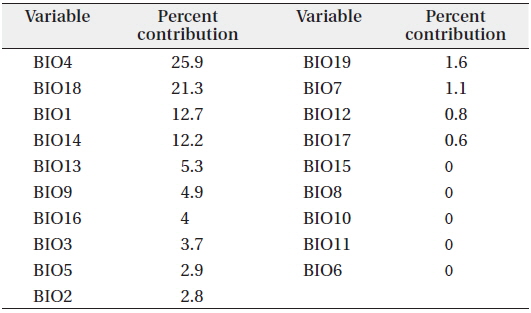
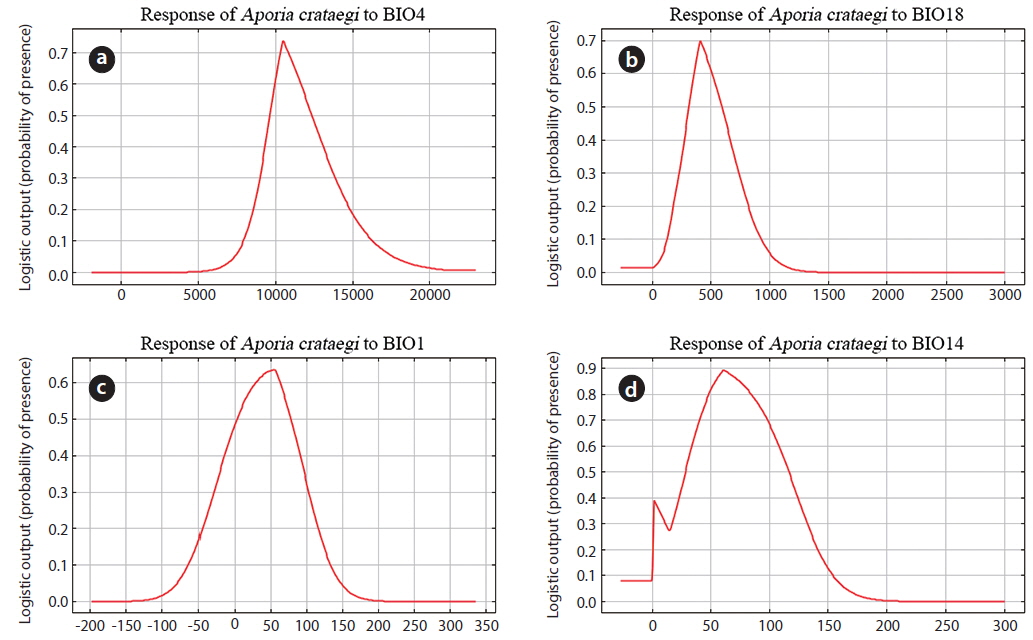
Among the 19 variables, BIO1 to BIO19, which affect the potential distribution of
[Table 3.] The descriptive statistics of bioclimatic variables

The descriptive statistics of bioclimatic variables
For the variable BIO4, which is the deviations in the monthly mean temperatures, the probability was highest at 73.7% in the regions where the deviation was 10.4°C. This result shows that the probability of the presence of
>
Changes in the Aporia crataegi distribution in accordance with climate change
We divided the changes in the potential habitable zones of
Compared to the current potential habitable zones, the future potential habitable zones were expanded in 13% of the regions and reduced 60% of the regions, with 26% of the regions showing no changes by 2050. The future potential habitable zones expanded in the Primorsky, Khabarovsk, and Sakhalin regions of Russia were reduced in the neighboring regions between North Korea and China; Hokkaido in Japan; and the Chengde, Shanxi, Shaanxi, Sichuan, and Gansu regions of China (Fig. 4). Also, the future potential habitable zones for the 2070s were expanded in 20% of the regions, reduced in 66% of the regions, and remained the same in 14% of the regions. The future potential habitable zones expanded in the Primorsky, Khabarovsk, and Sakhalin regions of Russia and Heilongjiang in China were reduced in the neighboring regions between North Korea and China; Hokkaido in Japan; and the Chengde, Shanxi, Shaanxi, Sichuan, and Gansu regions of China (Fig. 4). Specifically, it was noted that the habitable zones with a high probability of the presence of
Compared to the current habitable zones, the zones with probabilities lower than 25%, in other words the ‘Low’ zones, appeared to increase slightly, whereas the Medium, High, and Very High zones decrease overall in the 2050s and 2070s (Table 4). The Very High zones, with 75% or above probabilities throughout northeast Asia will dramatically reduce to 58,897 km2 in size by the 2050s and 28,492 km2 in size by the 2070s, from 124,107 km2 at present. Especially in Japan, the total Very High zone area in Hokkaido is currently 49,734 km2, but it will be reduced to 1,707 km2 by the 2070s. In Russia, however, the area of the High zones, with probabilities between 50-75%, will increase to 239,091 km2 from 163,822 km2, while the area of the Very High zones with probabilities above 75% will decrease only slightly, from 3,385 km2 to 2,967 km2 in 2070s.
[Table 4.] Changes in the potential distribution area (km2) of Aporia crataegi in northeast Asia
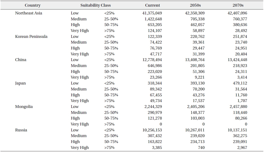
Changes in the potential distribution area (km2) of Aporia crataegi in northeast Asia
The area of the Very High zones with probabilities above 75% in 2070s for all of northeast Asia is expected to be 28,492 km2, of which 20.404 km2, accounting for 71.6%, will be located in the region north of the Korean peninsula. Thus, it is expected that