Habitat fragmentation caused by linear disturbances such as roads, railways, and pipelines has been cited as one of the most widespread threats to wildlife conservation (Forman et al. 2003, Trocmé et al. 2003, Beasley et al. 2014). Conservation efforts and management measures have been implemented to mitigate the negative effects of linear disturbances on wildlife habitats. For example, wildlife passages (i.e., wildlife overpasses, underpasses, wildlife-adapted box culverts, wildlife fences, and roadlevel crossing structures) have increasingly been applied by natural resource managers and road planners internationally (Mata et al. 2008, Neumann et al. 2012).
The construction and expansion of road networks have increased dramatically in Korea, and most have been conducted without wildlife passages (Choi and Park 2007, Ministry of Environment of Korea 2010). With the increasing number of wildlife-vehicle accidents near fragmented habitats, the Korean government has recognized the negative effects of roads on wildlife species’ habitats and established a master plan for wildlife-vehicle collision mitigation measures (Ministry of Environment of Korea 2010). Habitat fragmentation due to road construction is particularly destructive for mammals that have relatively large home ranges; it causes isolation from resources and potential mates, as a result of habitat separation by roads, individual mortality by collisions with vehicles (Dodd et al. 2004, Mata et al. 2008), division of preferred habitats by roadways (Beasley et al. 2014), and restricted movement (Peterson et al. 2003, Rodriguez-Morales et al. 2013).
Recently, wildlife passages have proliferated in many countries to reduce the number of wildlife-vehicle collisions (Mata et al. 2008, Bager and Fontoura 2013). In Korea, about 164 wildlife passages of various types have been built during the past few decades (Choi et al. 2012). However, the road-related mortality of wildlife species continues to increase. Moreover, the monitoring of wildlife passages showed that some passages have been constructed in inappropriate locations, as wildlife species rarely appear at the wildlife passage structures (Ahn et al. 2004). Most wildlife passage structures have been built with limited knowledge of wildlife habitat. Road planners and natural resource managers of wildlife passage need the quantitative approaches on habitat suitability to identify (1) suitable locations for the construction of wildlife passages where the risk of wildlife-vehicle collisions is predictably high; (2) the most suitable type of wildlife passage such as an overpass or underpass structure; and (3) other mitigation measures such as wildlife fences that would be proposed in the heavily fragmented areas.
Habitat models can be used to delineate habitat suitability maps, which can then be used to predict the most suitable areas for wildlife overpass structures on broad scale landscapes. Candidate locations may be identified using the spatial analysis of habitat suitability maps and existing road systems. Few studies have been conducted to determine suitable locations for wildlife passages (Clevenger and Waltho 2005, Mata et al. 2008, Thurfjell et al. 2015). Moreover, many wildlife passage studies have analyzed on a fine scale (Lee et al. 2002, Taylor and Goldingay 2003, Choi and Park 2007).
In this study, a spatially explicit habitat model for wild boars was developed and used to delineate a landscape-scale habitat suitability map to locate candidate sites for wildlife passages on a broad scale. The specific objectives of this study were to: (1) select a target species based on ecological characteristics and management strategies related to wildlife-vehicle collisions; (2) to develop a spatially explicit habitat model for the target species; (3) to suggest candidate sites derived from habitat maps superimposing the existing road systems; and (4) to describe the use and limitations of habitat suitability maps for selecting wildlife passage sites in severely fragmented landscapes.
>
Selection of a target species
What is the best target species for constructing and managing wildlife overpasses? There is no single answer to this question because of the variations in topographical features and population dynamics in Korea. Wildlife underpasses such as wildlife-adapted culverts have been constructed for many wildlife species including mammals, fishes, amphibians, and reptiles (Taylor and Goldingay 2003), whereas most wildlife overpasses (e.g., wildlife bridges) have been built to facilitate the movement of ungulates, birds, small-medium vertebrates, and carnivores (Dodd et al. 2004, Gunson et al. 2011). In Korea, Eurasian otters (
Conflicts between humans and wildlife, especially with the wild boar (
In this study, the wild boar was selected as the target species. It has attracted the attention of the government and researchers, and was considered to be one of the 100 worst invasive species by the International Union for Conservation of Nature (Lowe et al. 2000), in that it was the cause of environmental and economic damage (Kim et al. 2014). The population size of wild boars has increased dramatically in Korea, with higher population densities occurring in mountainous regions than homogeneous agricultural and coastal regions (Won and Smith 1999, Park and Lee 2003, Choi et al. 2006). Wild boar-vehicle collisions cause tremendous damage due to the wild boar’s body weight, resulting in human injuries (Beasley et al. 2014). The habitat requirements of the wild boar have been well documented (Kim et al. 1998, Park and Lee 2003, Lyang and Lee 2010, Li et al. 2013).
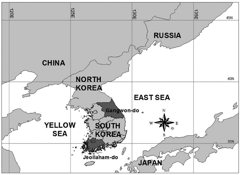
Gangwon-do and Jeollanam-do were selected as study areas to identify species-habitat relationships in mountainous and agricultural regions (Fig. 1). These two regions are among the top five most hazardous provinces in Korea regarding this issue (Ministry of Environment of Korea 2010). Gangwon-do is a rugged mountainous region with ≥80% forest cover, but now faces high development pressures. In particular, many valuable wildlife habitats have been fragmented by the rapid construction of recreational facilities and roads for the 2018 Winter Olympics to be held in this province. Jeollanam-do has long been recognized as a major agricultural area and comprises of 327,723 ha of cropland in Korea. The climate is characterized by rainy summers and dry winters. The average annual temperatures of Gangwon-do and Jeollanam-do are 12.9°C and 13.8°C, and the annual precipitation averages are 1,116 mm and 1,089 mm, respectively (Korea Meteorological Administration 2013).
Habitat use is a fundamental component of habitat models for wildlife species. In this study, habitat use data was collected from extant literature and surveys from wildlife experts via the Delphi method (Crance 1987). The ecology of wild boars has long been characterized especially by their food habits, daily movements, and habitat requirements (Kim et al. 1998, Park and Lee 2003, Lyang and Lee 2010, Thurfjell et al. 2015). Habitat models for wild boars have been developed, based on winter foods, hiding and sleeping cover, water, and reproductive requirements (U.S. Fish and Wildlife Service 1981). The influence of foods, covers, and reproductive components on habitat quality was measured at each site by assessing the relationship between environmental variables and suitability indices. For example, wild boars cross roads to croplands, mainly for foraging purposes in mixed landscapes (Thurfjell et al. 2015). The size of each site for habitat quality evaluation was determined by considering the daily movement and home range of the species.
The wild boar is usually found in a variety of habitats from moist oak forests in eastern Korea to agricultural landscapes in southern Korea. As its species have different feeding habits and movement patterns depending on the season, habitat use is described on a broader scale for the entire year, which allows for the development of landscape- level habitat models. Wild boars are concentrated in oak forests mixed with croplands that produce enough acorns, mast, and agricultural crops (Seo 2000, Kim et al. 2014). In the winter season, food availability in the habitat is especially critical for wild boars. Oak trees of 20 years old or older produce an abundance of acorns, which are an essential food source and an attractive habitat feature for wild boars (Yoo 1999). In the winter, wild boars have difficulty finding roots, forbs, mushrooms, and seeds on north- and west-facing slopes that are covered with heavy snow. Therefore, south- and east-facing slopes are assumed to be their feeding sites during the winter (Kim et al. 1998, Park and Lee 2003).
Refuge sites of wild boars are located preferentially in areas with (1) abundant above-ground plant cover, (2) deciduous forests, and (3) areas far from trails (Fernandez-Llario 2004, Lyang and Lee 2010). In this study, only “the distance to roads” variable was used to assess the cover requirements for wild boars (Li et al. 2013), because the variables related to plant cover and deciduous forests are highly correlated to the presence of oaks. The boars are wary and prefer areas where human activity is minimal. Park and Lee (2003) suggested that wild boars use areas >310 m away from paved roads. The presence of water is also essential for wallowing and rooting, and oak trees with their relatively dense understory are used for their bedding and shelter (Meriggi and Sacchi 2001). Therefore, “distance to roads” as well as “water accessibility” were selected as habitat variables representing cover requirements.
The ages and densities of trees were quantified to develop a habitat model that fulfills the reproductive requirements of wild boars. Most reproduction sites are located in older forests (Fernandez-Llario 2004). Woodlands, especially late-successional forests such as broadleaved and mixed woodlands, provide high quality food and shelter (Meriggi and Sacchi 2001). Dense and mature hardwoods provide abundant food with high nutrient value (e.g., insects) and secure places for rearing piglets.
In summary, wild boars frequently inhabit areas with mature hardwoods, and they are commonly found around oak trees on south- and east-facing slopes (Yoo 1999). The species wallow in wet, muddy areas, and dwell near areas that provide dense protective cover and ample food such as acorns and other hard mast (Sjarmidi et al. 1992, Yoon et al. 2004). Moreover, they prefer relatively remote areas, away from roads, human trails, and settlements (Table 1).

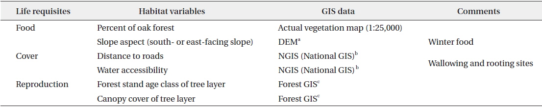
Life requisites, habitat variables and GIS data used for habitat model development of the wild boar (Sus scrofa Linnaeus)
Expert experience and knowledge were used to quantify the relationship between habitat variables and suitability indices of wild boars using the Delphi approach (Crance 1987). The Delphi approach was one method used for combining the knowledge on wild boars and opinions of a group of experts. Mammal ecologists, field technicians, plant ecologists, environmental planners, and several natural resource managers participated in the model development and evaluation procedures. Selection of habitat variables related to wild boars and habitat suitability curves development against habitat variables are difficult with limited knowledge on the species currently available, and the Delphi technique has been successfully applied in the development of habitat suitability curves (Crance 1987). Habitat suitability curves describe the relationship between habitat variables and the probability that wildlife will use a habitat with those particular characteristics. For each habitat variable, a suitability curve was generated to assign a habitat suitability index.
Coniferous and plantation forests without
Late-successional forests often have complex disturbance histories that can result in stands with widely varying structures, provisioning suitable habitat quality; late-successional forests with older trees might have higher habitat suitability indices. Forest stands with higher diameters at breast height (DBH) provide more mast than early-successional forests. According to the “Digital Forest Map” created and managed by the Korea Forest Research Institute, the forest stand age class A (0–10 years) equates to a habitat suitability value of 0.2 for wild boars (Rho et al. 2005). This age class is too young to provide acorns and other food resources. Forest stand age class B (11–20 years) has a value of 0.4, and forest stand age class C (21–30 years) has a higher habitat suitability value of 0.7. The average forest stand of trees >30 years old is likely able to provide enough food, cover, and breeding places for wild boars, and thus, a habitat suitability index of 0.9 was assumed.
Road construction may affect wildlife habitats, directly or indirectly. Native wildlife habitats are often destroyed during road construction. Road construction often facilitates human access to the neighboring areas of the roadside and decreases habitat quality of forest species (Sherwood et al. 2002). For such reasons, the buffer area of within 30 m of a major road has been assigned a habitat suitability value of zero. The buffer areas of 30-100 m from major roads have been given a habitat suitability value of 0.2. If the distance was 100-300 m from major roads or 100 m from secondary roads, a habitat suitability value of 0.5 had been assigned. The buffer areas of 300-500 m from major roads or 100-300 m from secondary roads were assigned a habitat suitability value of 0.7. The value 1.0 has been given to areas farther than 1,000 m from major roads or 300 m from the secondary road buffered area.
A moving window approach was used to evaluate the habitat quality of each focal site (Riitters et al. 1997). The relative importance of habitat variables (percentage of oak forest, distance to roads, slope aspect, tree density, forest stand age class, and water accessibility) in predicting species abundance was calculated based on 67,824 moving windows in Gangwon-do and 45,779 moving windows in Jeollanam-do. The moving window was circular, and had a 3-km radius, representing an estimated home range of 372-621 ha (Saunders and McLeod 1999, Choi et al. 2006). The circular moving window was moved systematically across the study site in steps of 500 m. The moving steps represented the daily distance that a wild boar travels, which was estimated to be 0.5–2.5 km (Grzimek 1972). ArcView GIS 3.x with Spatial Analyst (Environmental Systems and Research Institute, Inc., Redlands, CA, USA) and SYSTAT 12.0 (SYSTAT Software Inc., San Jose, CA, USA) were used to quantify the habitat suitability index of each moving window.
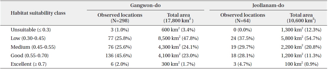
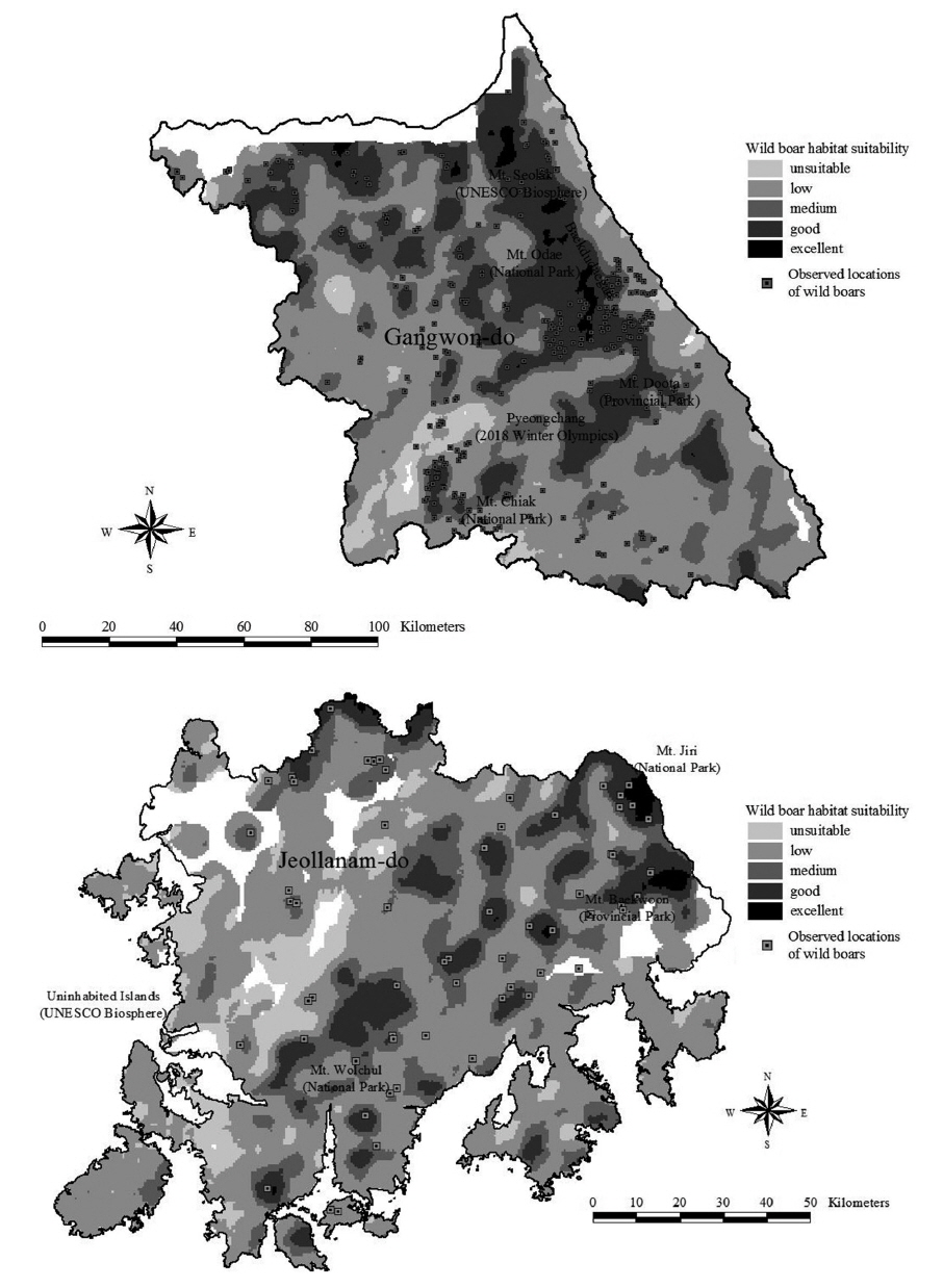
The individual pixels of the habitat suitability index maps were classified into five categories according to the following suitability categories: (1) unsuitability (≤0.3), (2) low suitability (0.3–0.45), (3) medium suitability (0.45–0.55), (4) good suitability (0.55–0.7), and (5) excellent suitability (≥0.7) (Table 2). The habitat suitability model was validated against locations where wild boars were observed. The observed locations of the species were recorded in the “Nationwide Survey of Natural Environments” through direct observations and field signs such as rubs, crossings, trails, wallows, rooting areas, and scat, which were often the only visible signs indicative of the presence of boars. This survey data had been collected during 1998-2007 by 36 mammal field technicians (Rho et al. 2005).

Comparing the habitat suitability of sites where wild boars were observed in areas of Gangwon-do and Jeollanam-do, Republic of Korea In Gangwon-do, wild boars were observed at 298 sites, among which 142 were good or excellent in habitat suitability quality and 80 were low or unsuitable habitats. In Jeollanam-do, wild boars were observed at 64 sites, and no boars were observed in unsuitable areas of habitat model.
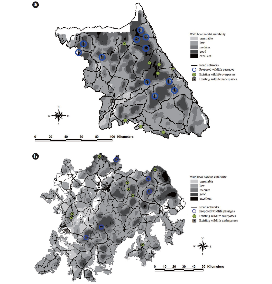
Habitat suitability maps of wild boars for the two study sites show that Gangwon-do consists of more suitable habitat conditions than Jeollanam-do; however, the habitats in Gangwon-do are highly fragmented compared to Jeollanam-do. Suitable habitats for wild boars in Gangwon-do are primarily located near the Baekdudaegan mountainous region (Fig. 2). The core areas of wild boar habitats stretched along the Baekdudaegan mountain range, including Mount Seolak, Mount Odae, and Mount Duta, to the eastern coastal region of the province. In Jeollanam-do, on the southern part of the Baekdudaegan mountain range, Mount Baekwoon and Mount Jiri had higher habitat suitability values than other regions of the province.
The occurrences of wild boars have been recorded at 298 locations in Gangwon-do and 64 locations in Jeollanam-do during 1998-2007, by the “Nationwide Survey of Natural Environments.” The results of habitat suitability maps for wild boars showed that the habitat suitability model was reasonably accurate (Fig. 2). The habitat suitability maps correctly classified that compared to 24.6% and 11.7% of excellent and good habitats for wild boars in Gangwon-do and Jeollanam-do, respectively, the species occurrences from the nationwide survey were highly concentrated in excellent and good habitats (47.6% in Gangwon and 32.8% in Jeonnam). However, some wild boars appeared to inhabit less suitable or even unsuitable areas when comparing habitat suitability maps and locations recorded during the nationwide survey (Table 2).
Paved road systems in this study include national highways, and regional and local roads. Habitat suitability maps show that habitats for wild boars in both Gangwon-do and Jeollanam-do are highly fragmented by paved roads. Habitat patches, which appear to be fragmented by roads, were derived from habitat suitability maps in order to identify potential sites for wildlife overpasses. This study proposes 11 and 5 wildlife passages to connect fragmented habitats in Gangwon-do and Jeollanam-do, respectively (Fig. 3).
Locations of proposed wildlife passages were selected by considering habitat suitability maps of wild boars and current wildlife passage distribution. The proposed locations were chosen in highly fragmented areas that were regarded as suitable habitats for wild boars. Twelve wildlife passages have already been constructed in Gangwon-do; 3 overpasses and 9 underpasses have been constructed to enhance animal movement and human safety from road-kill accidents (Fig. 3a). Among the 12 existing wildlife passages in Gangwon-do, seven passages in the eastern and northern areas have been located in suitable sites where habitats have been disturbed by road construction, but five passages have been built in unsuitable habitats in the southern part of the province. In summary, 11 sites are proposed as locations for wildlife overpasses in Gangwon-do.
In Jeollanam-do, 5 sites are proposed as suitable locations for wildlife passages. Ten wildlife passages have been constructed in this province (Fig. 3b), of which 3 are overpasses, and 9 are underpasses (Ahn et al. 2004, Ministry of Environment of Korea 2010). Some of the existing wildlife passages have been built in appropriate locations, but some other passages have been constructed in unsuitable regions. Considering the current wildlife passages located in fragmented landscapes, 5 sites are proposed as potential locations for building wildlife passages based on habitat suitability maps of wild boars.
The results indicate that habitat suitability maps derived from habitat models provide information on the appropriate location of sites for the construction of wildlife passages. These predictions can be used to minimize wildlife-vehicle collision problems in the planning stages of roads; wildlife passages are essential measures to reduce wildlife-vehicle collisions, and to connect fragmented habitats (Sherwood et al. 2002, Clevenger and Waltho 2005). Many wildlife passages previously constructed in Korea have been created without habitat suitability analysis of their selected locations in conjunction with insufficient data on the target species and ecological knowledge (Ahn et al. 2004). This study shows how to select target species and suitable locations for wildlife passages based on habitat models and ecological characteristics.
Some studies have suggested that locations and composition of wildlife passages may be related to scarce wildlife data and ecological knowledge (Ahn et al. 2004, Thurfjell et al. 2015). Besides using habitat suitability maps of target species to determine wildlife passages, road-kill data has been effectively used to select suitable location of the structures, but the road-kill data has not been available in the planning stages (Mata et al. 2008, Neumann et al. 2012). The use of habitat suitability maps is a quite well-established tool for obtaining public support and identifying potential wildlife movements, since it clearly shows the most suitable habitats and disconnected locations due to road construction (Clevenger et al. 2002). In this study, expert opinions and literature-based habitat models for wild boar have been well organized, and this approach provides the most reliable habitat suitability maps for Gangwon-do and Jeollanam-do. However, for species where little ecological knowledge is available or which exhibit large differences of ecological knowledge depending on its inhabiting area, this approach may not be suitable.
Target species composition and abundance in the study areas are considered at the landscape scale to establish effective mitigation strategies related to road networks. In extensively fragmented temperate forests, the location and construction of wildlife passages should consider mammals as target species because of their potential to damage vehicles and be killed by wildlife-vehicle collisions. Furthermore, umbrella species that are recognized as threatened or in need of management should also be considered. Because of the high cost of passage construction, suitable sites for passages should also be hospitable to the movements of smaller species, i.e., small mammals, birds, amphibians, and reptiles (Choi and Park 2007). As species composition and geographical distribution fluctuate with the seasons, a minimum one-year field survey is necessary to estimate the population size and species composition, both of which are factors used to identify target species for wildlife overpasses. In some areas where some species are endangered due to habitat fragmentation, the species are also included as target species.
Even though the results appear to be coherent and the habitat models performed well during validation, the results should be considered cautiously. Habitat models for wild boars were developed at the landscape-scale approach, so local variations such as microclimate, roadside plant composition and structures, and natural barriers related to the animal movement was not considered in this knowledge-based habitat model. Landscape-scale habitat models play an essential role in determining the overall location of wildlife overpasses, and local-scale features are used to identify the placement of specific wildlife overpasses (Malo et al. 2004). After selecting potential candidate locations for wildlife overpasses based on habitat suitability maps at the landscape level, an assessment of ecological characteristics on a fine scale helps facilitate the selection of more specific locations for wildlife overpasses. Also, regional characteristics at the provincial level are adapted to choose reliable mitigation measures to reduce wildlife-vehicle collisions. To effectively reduce wild boar-vehicle collisions, wildlife overpass structures should be located between suitable habitats that are divided by roads (Beasley et al. 2014). In addition to the installation of wildlife overpasses, roadside vegetation and planting on each side of the wildlife overpass should be considered to ensure that wild boars are deterred from using unsafe crossing points. Relatively wide areas of good quality habitat adjacent to the wildlife overpasses encourage the use of the overpasses between fragmented habitats.
Wildlife-vehicle collision data has often been used to evaluate habitat maps. Currently, few attempts have been made to use wildlife-vehicle collision data in the selection of target species for the placement of wildlife overpasses in Korea. Even though many wildlife species (e.g., water deer, raccoon dogs, and Eurasian badgers) have been killed on highways and roads across the country, few habitat models have been developed. Further efforts are necessary to calculate the effects of wildlife passages in conjunction with the construction of wildlife-adapted culverts and roadside fences, and research to improve habitat models for target species based upon road-kill data is warranted. The habitat suitability maps derived from habitat models integrate all wildlife data and ecological knowledge on target species and constitute a management tool for road planners and natural resource managers who are interested in reducing wildlife mortality in extensively fragmented forests. This quantitative approach is selected as a management tool for reducing wildlife-vehicle collisions in Gangwon-do and Jeollanam-do. However, to achieve the final aim of mitigating the increase of mortalities, it is necessary to assess land cover and species composition of each province. In Gangwon-do, wildlife overpass structures have been usually constructed where mountainous regions with rugged topographic characteristics were dominated by mediumlarge predators. However, there are widespread croplands throughout Jeollanam-do, and wildlife species related to cropland have been heavily observed near the roadside regions of the province. Many underpass structures have been constructed in Jeollanam-do. Wildlife-vehicle collision data focusing on existing wildlife passages should be collected to validate the appropriate sites for future wildlife crossing structures. This data collection should survey road-kill species, sex, age, and weight in each collision along the roadside, as well as land cover and land use of geographic locations neighboring the accidents. Knowledge of the geographic locations where animals have been killed on the road would help in the selection of appropriate locations for wildlife passages.
As construction of wildlife passages at suitable locations is probably not sufficient to reduce animal-vehicle collisions, efforts should be made to improve and maintain wildlife movement within corridors by expanding vegetative clearings along roadsides, and reduce obstacles to movement based on the results of fine-scale field surveys. Wildlife overpass management has effectively installed fences along roads to reduce wildlife road-kills, road signs to alert drivers about the presence of animals on the road, and mirrors to dissuade animals from crossing (Ministry of Environment of Korea 2010). Such management measures affect the overall quality of connectivity within a landscape for target species such as wild boars.