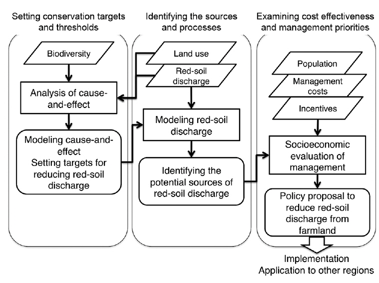
After the reversion of Okinawa (Ryukyu Islands) to Japan in 1972, extensive urban and agricultural development resulted in a significant increase in sediment discharge to coastal waters. The release of sediment has caused the degradation of freshwater and coastal ecosystems and biodiversity. A consideration for catchment-to-reef continua, as well as agricultural (socioeconomic) factors is necessary to establish proper land-based management plans for the conservation of the island environment. We have set up a framework to integrate biophysics and socioeconomics: 1) setting a conservation target and threshold, 2) identifying the sources and processes, and 3) examining cost-effectiveness and management priorities. The framework may be applicable to other tropical and subtropical islands with similar characteristics.
Both terrestrial and coastal island ecosystems are particularly vulnerable to environmental change that includes global warming (Bellard et al. 2014), anthropogenic stresses (Fujita et al. 2014), and biological invasions (Veitch et al. 2011). The small geographical size of most islands and their remoteness from the mainland often results in a unique evolutionary history and ecosystem, and also makes islands more vulnerable to environmental change than the mainland. Because of the small geographical size of most islands, human activities can cause an immediate degradation of terrestrial and coastal ecosystems and biodiversity. A prominent example is the increase in catchment-based pollution caused by population growth and/or extensive land development. A recent estimate indicates that catchment-based pollution is ranked next to overfishing and destructive fishing and it affects up to 30% of the world’s coral reefs (Burke et al. 2011).
An integrated approach that considers land–sea interaction is required to develop an island biodiversity conservation plan (Stoms et al. 2005). A relevant case study for integrated environmental management is the Great Barrier Reef (GBR) in Australia (see special issues of the
In this paper we provide an overview of the current status of catchment-based pollution that affects island ecosystems and biodiversity in the Ryukyu Islands, Japan. We then provide a brief introduction of our ongoing project at Kume Island in the Ryukyu Islands to illustrate the importance of integration of biophysics and socioeconomics for conservation of island ecosystems. The geographical setting of Kume Island has characteristics found on many subtropical and tropical islands, and thus, the approach could be easily applied to other island environments.
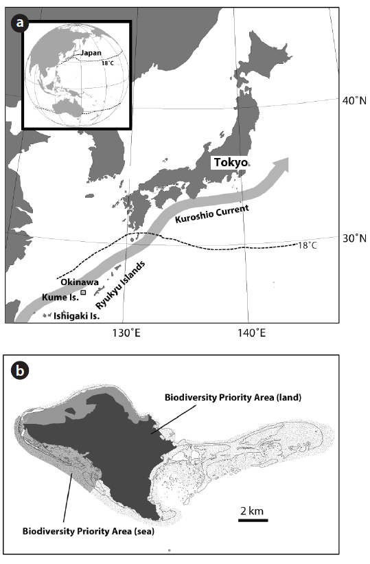
The Ryukyu Islands are located at the southern part of Japan (Fig. 1) and are fringed by mangrove forests and coral reefs (Kayanne et al. 2004). The islands are in an ecotone between the Palearctic and Indomalaya ecozones, with flora and fauna of both northern and southern origin. The islands developed along the eastern margin of the Eurasian continent, and have been separated from the continent several times in their geological history. This separation has allowed the evolution of a range of endemic species. The islands are also home to many rare species listed on the Red Lists of the Japanese Ministry of the Environment and the International Union for Conservation of Nature and Natural Resources (IUCN) (Yasumura 2011).
The Ryukyu Islands have a subtropical climate and, in Okinawa, the mean annual air temperature ranges from 21.5°C to 24.0°C. Annual rainfall exceeds 2000 mm, 60% of which falls in the rainy season from May to June or is associated with typhoons in August and September (Iryu et al. 1995). The Kuroshio Warm Current flows into the East China Sea, passes northwestward along the islands, and exits to the Pacific through the Tokara Strait. Due to the Kuroshio Warm Current, annual sea surface temperatures along the Ryukyu Islands generally ranges from 18°C to 30°C, which is favorable for coral reef development (Veron and Minchin 1992).
Kume Island is located approximately 100 km west of the main Okinawa Island (Fig. 1a) and has an area of 59 km2. The island is composed primarily of volcanic and carbonate rock. The central part of the island is composed of old volcanic rock and reaches a maximum altitude of 310 m above sea level. The west and south parts of the island are composed of Pleistocene carbonate rock (Ehara et al. 2001). Coral reefs fringe the island, and barrier reefs and associated reef islands are found in the eastern part of the island.
Kume Island is home to several endemic species including a firefly (
After the reversion of Okinawa to Japan in 1972, extensive urban and agricultural development has resulted in a significant increase in sediment discharge to coastal waters (Omija 2004). The sediment is called “red soil” due to its color, and contains abundant silt- and clay-sized particles that have caused severe degradation to the health of both river and coastal ecosystems in Okinawa (Kishimoto et al. 1995, West and van Woesik 2001, Omija 2004). The suspended solid concentrations in rivers on Okinawa’s main island are as high as 6276 mg L−1 during the rainy season (Shimoji 2012). Land-based pollution may also affect the resilience of coral to other environmental changes, including global warming (Wooldridge and Done 2009). In the Ryukyu Islands, for example, coral affected by chronic stress from red-soil pollution have not recovered after the 1998 mass bleaching event caused by anomalously high sea surface temperatures (Hongo and Yamano 2013). Corals at Sesoko Island, on the other hand, were not as affected by red-soil pollution and showed a significant recovery after the 1998 mass bleaching event (Van Woesik et al. 2011).
In response to environmental degradation due to redsoil pollution, Okinawa Prefecture established the Okinawa Prefecture Red Soil Erosion Prevention Ordinance in 1994, with enforcement initiated from October 1995. As a result, red-soil discharge from construction sites was successfully restricted; however, red-soil discharge from farmland is not fully regulated and this continues to be a significant source of red-soil pollution (Omija et al. 2002). An integrated assessment and reconstruction of land use changes at Ishigaki Island using aerial photographs and geochemical analysis of annual coral bands indicates that land modification has caused an increase in redsoil and nutrient discharge into coastal waters, resulting in an increase in seagrass area and a decrease in coral cover (Hasegawa 2011, Harii et al. 2014, Inoue et al. 2014, Yamazaki et al. 2014, Yamano and Watanabe in press).
Currently, sugarcane and pineapple fields appear to be the main source of red-soil discharge from farmland (Higa et al. 1995). In the Ryukyu Islands, the sugarcane harvest occurs from January to March. There are three key sugarcane growing practices: 1) ratooning, which grows sugarcane from sprouts of underground stubble left in the field after harvest of the main crop; 2) spring planting of seedlings in April, just after harvesting; and 3) summer planting of seedlings in August and September. During summer planting, bare soil may be exposed from April to August, which allows rain during the rainy and typhoon seasons to carry away large amounts of red-soil from the farmland.
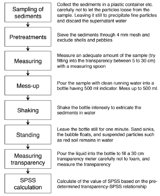
To quantify and monitor red-soil discharge, the Suspensible Particles in Sea Sediment (SPSS) method was developed by the Okinawa Prefectural Institute of Health and Environment (Omija 1986, 2003, 2004). It applies conventional methods to calculate the amount of fine red soil in sea floor sediment (Fig. 2). The same procedure can be applied to river sediment, and it is called the Suspensible Particles in River Sediment (SPRS) method (Hanashiro et al. 1995). These methods have been deployed widely for decades and made it possible to compare red soil content in sea sediments before and after the enforcement of the Okinawa Prefecture Red Soil Erosion Prevention Ordinance (Omija et al. 2002).
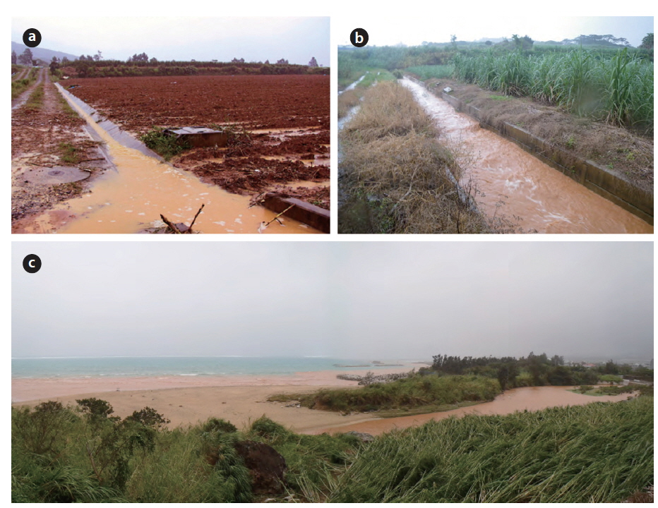
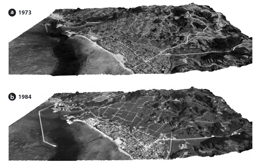
As with other islands in the Ryukyu Island group, significant land development and modification occurred on Kume Island after 1972 (Fig. 3), and it resulted in severe red-soil discharge from sugarcane farmlands (Fig. 4). The suspended solid concentrations in rivers on Kume Island can reach up to 2170 mg L−1 during rainy periods (Omija et al. 1998). In addition to all negative impacts of red soil on coral reefs in the Ryukyu Islands, Sato (2008) used monitoring data from 2001 to 2007 to show that the abundance of the endemic species
>
Research framework to integrate biodiversity, red-soil discharge, and management
The main crop on Kume Island is sugarcane. Therefore, getting the management of sugarcane farmlands to halt or reduce red-soil discharge is a primary goal. Considerations for catchment-to-reef continua, as well as agricultural and socioeconomic factors are necessary to establish proper land-based management plans for the conservation of the island environment (Fig. 5).
>
Setting a conservation target and threshold
It is of primary importance to set a red-soil pollution threshold for maintaining healthy island ecosystems. In the GBR, the average suspended solid concentrations for coral mortality was determined to be 1.6 mg L−1 in the winter and 2.4 mg L−1 during the summer wet season (De’ath and Fabricius 2010). Although further investigation on the links between ecosystem health and sediment discharge are needed, targets to reduce land-based pollution were developed and adopted for the GBR (Brodie et al. 2012).
Extensive surveys for SPSS and coral cover in the Ryukyu Islands reveal clear relationships between red-soil content and coral reef status, providing solid baselines for coral reef conservation. Species-specific responses of corals to red-soil pollution are currently being assessed (Omija 1996, Hongo and Yamano 2013), which implies that further refinements of these baselines may be possible. Investigating the relationships between red-soil content and the status of other organisms (e.g., fireflies, mollusks, and mangroves) could also further contribute to setting the baselines, as river and coastal organisms may also be affected by red-soil pollution (Kishimoto et al. 1995, Sato 2008).
>
Identifying the sources and processes
Sediment discharge depends on rainfall patterns, soil erodibility, topography, and crop management (e.g., crop type and cover). To identify crop fields that have high sediment discharge, we used an integrated observation and modeling approach. We developed a sediment yield model based on Hydrological Simulation Program-Fortran (HPSF) (Bicknell et al. 1997) to calculate sediment discharge from individual crop fields based on land-use polygon data prepared by Okinawa Prefecture and updated by our fieldwork (Hayashi and Yamano unpublished). The sediment discharge results were validated by measuring water and suspended solid fluxes in a river in a sub-catchment on Kume Island.
Because each crop field generally has a small surface area (generally less than 10,000 m2 at Kume Island) (Tarumoto 2008), and crop growth patterns are dynamic and dependent on growing practices (ratooning, spring planting, and summer planting), catchment-scale crop-growth monitoring at a fine spatial and temporal resolution (i.e., daily) is required. To collect high-resolution data, we attached an automated digital time-lapse camera to a mobile phone network tower (Oguma and Ide in press). This camera contains an inexpensive multispectral sensor capable of monitoring red, green, and blue (RGB) visible wavelengths. Similar systems have been used to successfully detect forest phenology and other types of vegetation by using vegetation indices calculated from RGB color information (Ide and Oguma 2010).
>
Examining cost-effectiveness and management priorities
In addition to civil engineering works (e.g., slope gradient modification of cropland and setting grit chambers), several measures have been proposed to reduce sediment discharge from farmland. For example, the use of ratooning eliminates bare land after summer harvest and reduces sediment discharge. This method has the additional advantage of saving seedbed preparation for the new planting and reducing seeding and planting operational costs. However, ratoon crop yields are often lower than the main crop due to many factors including soil compaction and decreased soil fertility (Verma 2002). Another option is the introduction of cover crops before summer planting to increase vegetation cover and reduce sediment discharge. Planting a border of vegetation around a cropland (“green belts”) may reduce sediment discharge from the cropland. Cover crops and “green belts” are relatively inexpensive, but the application of this approach is highly depend on individual farmers.
Socioeconomic research is therefore required to examine the cost-effectiveness of different methods and to develop management priorities that includes identifying and enhancing incentives for better crop management (Van Grieken et al. 2013a, 2013b). Tools for this type of research have been developed for reserve design (Moilanen et al. 2009) and could be applied to develop crop management strategies. It may then be possible to develop priorities for crop management based on conservation targets and the identification of source areas. As stated in the previous section, site-specific information for each cropland is available, making it helpful to set up a real-world management plan (Horie et al. unpublished). Further, it is important to identify incentives for farmers to encourage them to reduce red-soil runoff based on socioeconomic and cultural backgrounds.
Ecosystem service accounting is another important issue. Butler et al. (2013), found that the most direct tradeoff in floodplain services and stakeholers was food and fibre production (farmers) versus water quality regulation (community, GBR tourists, tour operators, and fishermen). They also identified synergies between water quality regulation and floodplain recreational and commercial fisheries (fishermen). As Brodie et al. (2012) suggested, all catchment management measures known to benefit coral reef ecosystems will equally benefit freshwater ecosystems. Valuing terrestrial, freshwater, and coastal ecosystems would therefore contribute to achieving sustainable and healthy island ecosystems.
We have presented an integrated research framework to reduce red-soil discharge from farmlands on Kume Island and Ryukyu Islands, Japan. As within the GBR region (Brodie et al. 2012), other pollutants should also be monitored and reduced. The increased presence of blue-green phytoplankton, benthic blue-green microalgae, seagrass, and a decrease in coral cover also suggests a negative effect of increasing nutrient loading (Blanco et al. 2008, Hasegawa 2011, Harii et al. 2014, Yamazaki et al. 2015). Discharge of other potentially hazardous chemicals (pesticides, Irgarol 1051, chlorpyrifos, and bisphenol A) has also been observed in river water and coastal sediments in Okinawa and Ishigaki Islands (Kawahata et al. 2004, Kitada et al. 2008). Thus, another challenge for biodiversity conservation is examining cause-and-effect relationships and setting reduction targets for these materials. Conservation work on the GBR has achieved excellent outcomes; however, as stated by Butler et al. (2013), the results of their study are specific to one Australian floodplain and flood plume since other catchments and adjacent reef areas have different ecological and social characteristics. A management framework for the Ryukyu Islands must therefore consider the island’s unique ecological, geographical, and cultural features. The framework may then be applicable to other tropical and subtropical islands with similar characteristics.