Conservation drones are remote-controlled devices capable of collecting information from difficult-to-access places while minimizing disturbance. Although drones are increasingly used in many research disciplines, their application to wildlife research remains to be explored in depth. This paper reports on the use of Phantom 2 Vision+ for monitoring areas in two national parks in South Korea. The first research area was conducted in Chiaksan National Park, and the second in Taeanhaean National Park. The aim of this research is to introduce ecologists and researchers alike to conservation drones and to show how these new tools have are fundamentally helping in the development of natural sciences. We also obtained photographs and videos of monitoring areas within our test site.
Drones are robotic planes, also known as unmanned aerial vehicles (UAVs), unmanned aircraft systems (UAS)and remotely piloted aircrafts (RPAs). They have evolved and developed rapidly over the past decade, after being driven primarily for military and civilian purposes. Although they have a military background, it has now become clear that there are a lot of other areas where they might prove useful. Although they still remain to be fully developed and researched, unmanned aerial vehicles (UAV) will soon be an important commercial tool for monitoring purposes (Getzin et al. 2012).
A drone can provide a low-cost and low-impact solution to environmental managers working in a variety of ecosystems. Drones used for these purposes are referred to as “eco-drones” or “conservation drones.” Their agility and image quality abilities make them advantageous as a mapping tool for environmental monitoring, but there are still several challenges and concerns to be surmounted (Harriman and Muhlhausen 2013).
>
The use of robots in ecology
The use of robots in ecology is still in the infancy stage of development. However, the recent popularity of drones has developed a number of research groups around the world who are working diligently to develop as many different uses for these small machines as possible. Their most frequent application so far has been for monitoring previously inaccessible areas and for creating a map of the wildlife that lives there.
Ecology has only flourished as an area of research in the last 50 years, once the impact of global change became evident on both the lives of animals and those of humans as well. Researchers have since developed methods in ecology to monitor and help understand the impact of ongoing global change, improve the Earth’s biodiversity system, and predict the future trends of ecology and its development. In order to achieve these goals, the Earth must be monitored through a complete, accurate and rapid collection of data, which can now be done very efficiently with the help of drones.
Autonomous robots, in particular drones, sent to previously inaccessible areas, have revolutionized data acquisition not only for abiotic parameters, but also for recording the behavior of undisturbed animals and collecting biological material. Robots will also play an essential role in population ecology, as they will allow for automatic census of individuals through image processing, or via detection of animals that will be electronically marked (Grémillet et al. 2012).
>
Conservation drone platform types and characteristics
The conservation drone is a model aircraft fitted with an autopilot system. The autopilot unit consists of a computer, a GPS, a compass, a barometric altimeter and a few other sensors. A conservation drone is meant to carry useful payloads such as a video camera and/or photographic camera. It must also be equipped with a software that allows the user to program a mission and enable useful commands and operations.
Drones are categorized according to their size, mobility, autonomy, equipment and areas of use that they have been developed for. For example, most drones rely on well-developed positioning systems, which often use a GPS receiver or WiFi to follow a predetermined map, or to free fly with the help of ground control commands. Underwater drones use acoustic signals that send location data back to the researcher and organize a route plan to follow. Depending on their complexity, some are also equipped with 3D motion sensors, and can detect and avoid incoming objects without help from the researcher (Koh 2013).
When it comes to collecting ecological data, the drones are equipped with optical sensors (infrared and/or ultraviolet light included), physical sensors (temperature, pressure, humidity and conductivity), acoustic sensors (mainly for underwater use but can be used on land as well), and chemical sensors (e.g., pH sensors for detecting a great variety of gases). With such a detailed apparatus available, drones have an endless number of uses from monitoring the smallest ecosystems to analyzing large areas of land and climate change.
DESCRIPTION OF THE PHANTOM 2 VISION +
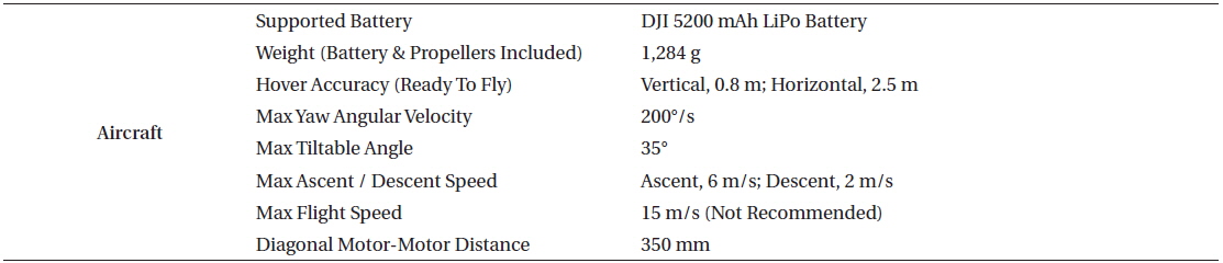
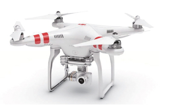
The UAV quadcopter named Phantom 2 Vision+ (DJI, Shenzhen, China), equipped with an autopilot system, was test-flown in the following study (Fig. 1). This airframe is capable of carrying a camera, which is designed to record images and videos. A total of 12 flights were conducted between the 4th and 17th September in 2014 for both flight testing and imagery acquisitions over an open field area. The purpose of the test flights was to examine the aircraft’s capabilities and monitor randomly selected open-land areas within national parks in Korea. More information about the aircraft specifications is in Table 1 (DJI 2014a).
[Table 1.] Aircraft specifications

Aircraft specifications
>
Integral components and characteristics of the Phantom 2 Vision +
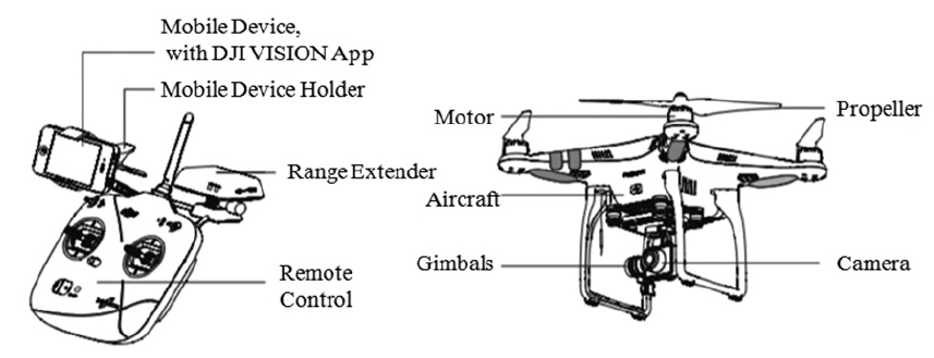
Fig. 2 shows the most important specifications and serves as an introduction to what the aircraft could later develop into. Further information can be found on the official DJI website.
The Phantom 2 Vision+ carries an extremely high quality camera and a removable 4GB micro SD card. It shoots full HD videos at 1080p/30fps and 720p/60fps, providing the researcher with crystal clear videos and the option for slow motion shots. Photos are shot at 14 megapixels. A built-in high precision 3-axis camera stabilization system insures a smooth flight and absolute control of the aircraft in the sky (NZ Camera 2013).
>
Precision flight and stable hovering
The integrated GPS auto-pilot system offers position holding, altitude lock and stable hovering, ensuring a constant smooth flight that is more focused on providing the perfect shot and is less distracted by outside influences (NZ Camera 2013).
The drone can be programmed with the use of a smart phone with the 16 waypoint Ground Station system (DJI). The camera can be tilted up and down, take photos and shoot videos all while the Phantom 2 Vision+ flies autonomously (NZ Camera 2013).
>
Radar positioning and return home
The flight radar displays the current position of the Phantom 2 Vision+ in relation to the pilot. Exceeding the control range of the remote control will trigger “Return-to-Home,” meaning that the Phantom 2 Vision+ will automatically fly back to its takeoff point and land safely (NZ Camera 2013).
All unmanned aerial vehicle (UAV) operators should abide by all regulations from such organizations as the ICAO (International Civil Aviation Organization) and their own national airspace regulations (Aerial Picture and Video 2015). In order to increase flight safety and prevent accidental flights in restricted areas, the Phantom 2 Vision+ includes a “No Fly Zones” feature to help users use this product safely and legally. These zones include airports worldwide and have been divided into two types, A and B. Type A includes large international airports. For category A, airports have established 8-km safety zones around these areas, which can be adjusted through the GPS database. In the first 2.4 km away from the safety zone, the drone will be unable to take off. From 2.4 km to 8 km away from the restricted area, an increasing high limit has been established from 2.4 km to 8 km (DJI 2014b). If a vision or a ground station application is being used, a warning will be issued in advance if the drone is within 100 m of category A safety zone. For category B, which includes much smaller airports, if the drone is less than 1 km away from restricted areas, it will be unable to take off. Again, with the vision or ground station application, the pilot will be warned in advance if they are within 1 km of entering a category B safety zone. The update will also prevent the drone from setting up the waypoints within 8 km of safety zones. The map showing waypoints safety areas can be found on the webpage dji.com/fly-safe (DJI 2014a).
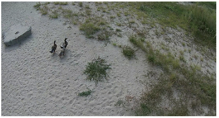
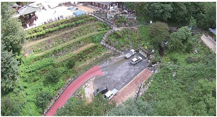
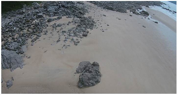
Test sites were located in two national parks in South Korea. The main aim of these missions was to obtain photographs and videos of monitoring areas within our test site, and to test how the drone would behave under different working conditions. The first test site was situated in the mountain inlands of Korea at Chiaksan National Park (Fig. 3), which was designated as the 16th national park in Korea in December 1984. Its total area is about 181.6 km², and east of its highest peak, Birobong (1,288 m), lies Hoengseong-gun and to the west is Wonju-si. Chiaksan National Park has many steep valleys among its high peaks ranging above 1,000 m such as Namdaebong in the south and Maehwasan in the north, and is known for having beautiful scenery with steep slopes. Chiaksan National Park has a total of 821 species of plants and is expanding its natural forest with Mongolian oaks and Japanese oaks. As for its inhabitants, there are a total of 2,364 animal species including 34 endangered species such as the flying squirrel and copper-winged bat (Korea National Park Service 2009a). The second test site was located in Taeanhaean National Park (Fig. 4). Taeanhaean National Park was designated as the 13th national park in Korea in 1978. There are 26 beaches along the 230 km coastline, which encompasses the Taean Peninsula and Anmyeondo. The park’s total area is around 326 km², and ranges across Taean-gun and Boryeong-si. There are 72 islands scattered across the calm sea of which only four are inhabited by people. The name “Taean (big comfort)” comes from the fact that the region did not suffer big natural catastrophes throughout history, and coupled with the mild climate and an abundance of food, it made for a non-weary life. As the only marine park in Korea where various coastal systems coexist, there is a great value in preserving the Taeanhaean National Park. The park is home to 1,195 animal species, 774 plant species, and 671 marine species. There are also 17 endangered species including Swinhoe’s egret, the Korean golden frog, and the otter. There are also protected natural treasures such as the Mandarin duck, common kestrel, and osprey (Korea National Park Service 2009b).
A key consideration in developing conservation drones is their ease of use for non-specialist operators, who would mainly include conservation workers and field ecologists (Koh and Wich 2012). The precise and detailed abilities of the drone enable almost anyone to acquire data from it, and to apply it to different natural science purposes as needed. This is an enormous step in the development and application of UAVs that spans beyond what was initially imagined by the military. The aim of this research is to introduce conservation drones to ecologists and researchers alike and show how these new tools are fundamentally helping the development of biodiversity monitoring (Fig. 5). The photos and data that have been so far acquired are only a glimpse of what can be achieved with drones and how they can be applied to other fields of research. However, this paper also hopes to serve as an inspiration for new ideas and developments in the future.
Our results are based on two independent protected regions within national parks in Korea, which are located several hundred kilometers apart from each other. The fact that drones were able to record information from these restricted areas is another proof of their usefulness in research and how far they can go where humans would be restricted of access.
A total of 12 flights were conducted in the autumn of 2014 for both flight testing and imagery acquisitions over open field areas for examining aircraft capabilities and monitoring the designated areas. Overall, the study has demonstrated a high potential for predicting biodiversity in different areas from high-resolution aerial images.
We hope that new methods for biodiversity assessments will be further developed from this research and that they will inspire strong communications between researchers around the world. The drone’s purpose is also to inform all ecologists of how the entire planet is changing and what can be expected of it in the future, which is why teams of drone researchers should be formed in key points around the world to strengthen communication.