For the past three decades, ship-to-ship collision accidents have steadily increased on the coast of South Korea by about 20% annually [1, 2]. Marine accidents have become more likely and more devastating in areas with increasing marine traffic and rising numbers of high-speed ships.
On December 14, 2011 at around 5 AM, OO Confidence, leaving the Gwangyang Port for Busan, collided with OO Carrier, heading for Samcheonpo in adjacent seas of Namhae-gun. The duty officer of OO Confidence recognized the OO Carrier through a very high frequency (VHF) call just 5 minutes before the collision and only 2 nautical miles away. The duty officer initially tried to cross the other ship’s course in front without changing its own course or speed, but at the request of OO Carrier, OO Confidence agreed to pass through the rear course, since the closest point of approaching was too close. However, the duty officer failed to veer to the changed path fast enough, as he did not properly understand the situation at that time. Instead of veering enough to the right, he turned the ship only slightly to the right. If he needed more time, he should have used the engine to slow the ship down, but he failed to do so. The duty officer of OO Carrier also did not monitor OO Confidence closely after the contact and failed to take a cooperative action for collision avoidance, which ultimately contributed to the collision [3-5]. This case highlights the important of taking preventive action in advance that is based on thorough lookout and precise judgment of the situation (Figure 1).
In addition, the Korean coast is often covered by thick fog in spring when over 30% of the country’s marine accidents are concentrated. Fog is generated when a large daily temperature range exists within a day, and this daily temperature range has increased each year due to weather abnormalities [6].
In this situation, safe navigation would be greatly enhanced if ships had means to exchange a navigator’s intention in emergency conditions.
Conventional means to communicate a navigator’s intention includes whistle signals, flash signals, and VHF communication. Whistle signals are an effective means of communication under restricted visibility and are capable of delivering a message based on the predetermined meaning of short and long sound arrangements. However, the direction of the sound should be determined by the duty officer. The distance from another ship is hard to gauge. When there are multiple ships around, it is difficult to determine which one sent the signal. Flash signals are an effective means of communication especially at night in a shared visibility situation. They can deliver a message through the arrangement of flashes [7-9]. However, with restricted visibility, communication would be difficult. VHF communication is effective regardless of visibility or weather conditions. However, it still has communication difficulties such as a language gap where, for example, a message sender wishes to communicate but is not properly answered or encounters hesitation to respond.
Another study on a navigator’s intention to communicate investigated a cooperative navigation support system. Here, the navigational intention exchange support system (NIESS) was installed in a radar to exchange a navigator’s intention via ultrashort wireless communication [10]. However, since it only marked indications on the radar screen, targets outside the radar were impossible to observe.
In this study, we designed and built a system for transmitting a navigator’s intention; the system is capable of communicating a navigator’s intention in any situation and provides a general picture of the surrounding situation at the same time. We also tested the effectiveness of the system.
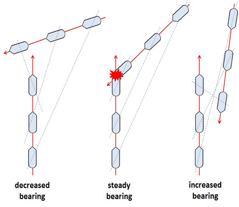
For safe navigation, a ship needs to identify its distance to other ships. To estimate collision risk, the duty officer should be able to identify another ship’s distance, bearing, and any increase, decrease, or steady in the other ship’s bearing (Figure 2).
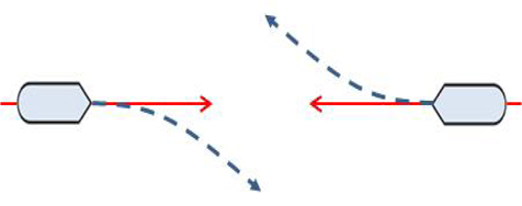
When ships with collision risk encounter each other head on, each should veer to the right to pass each other at portside (Figure 3).
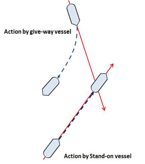
In the situation shown in Figure 4, one ship to steer to the right to avoid the other’s path and the other ship should steer to the left to maintain a constant course and speed. The former is called a give-way-vessel, and the latter, a stand-on-vessel. If the movement by the give-way-vessel alone is deemed insufficient to avoid collision, the best possible cooperative action should be taken.
According to established navigation techniques, action to avoid collision, during normal conditions, should be taken proactively in a sufficient amount of time and to a maximum extent [7].
As such, a navigator’s intention can be defined as an intention to steer toward a contain direction when collision risk exists. It would be most important in this situation for the involved duty officer make a judgment and decision in sufficient time with full active commitment.
The automatic identification system (AIS) was utilized to deliver a navigator’s intention. The AIS transmits binary messages to deliver navigation information. The number 6 message can be used for communication with a specific ship and the number 8 message can be used for announcements, for example [7].
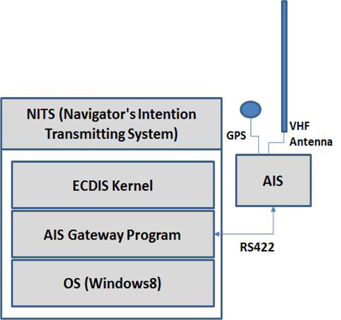
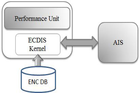
The navigators intention transmitting system (NITS)) was constructed as shown in Figure 5. The performance unit was based on the electronic chart display and information system (ECDIS) Kernel and was capable of exchanging input on the navigator’s intention via the AIS. The ECDIS Kernel could display by loading the electronic navigation chart from the electronic navigation chart database (ENC DB).
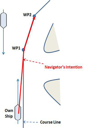
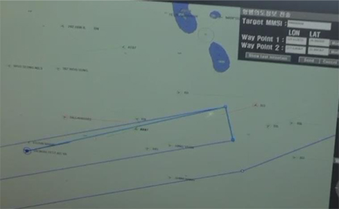
A navigator’s intention information was generated by the performance unit in two different methods. The first method automatically loaded the coordinates (latitude and longitude) of the two next waypoints in the recognized course (Figure 6), and connected them with the current position to form a navigator’s intention packet.
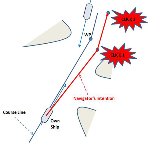
The second method clicked two random coordinates on the electronic navigation chart (Figure 7), to connect them to the current position and formed a navigator’s intention packet.
4. System Building and Ship Test
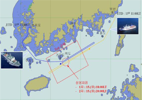
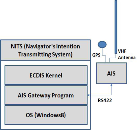
The NITS test environment is presented in Figure 8. It was built in the training ships Saenuri of Mokpo National Maritime University and Hanbada of Korea Maritime University. The test terminal could transmit a navigator’s intention information through the interface between AIS and RS422.
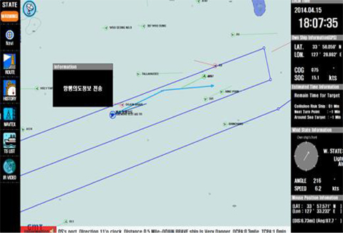
On April 15, 2014, a joint international e-Navigation test was performed on the south coast of Korea and the navigator’s intention to transmit information was tested in parallel. At that point of time, both ship’s courses were as shown in Figure 9. Saenuri left Mokpo towards the east, and Hanbada left Busan towards the west so that they encountered each other in the sea nearby Geomun Island.
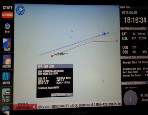
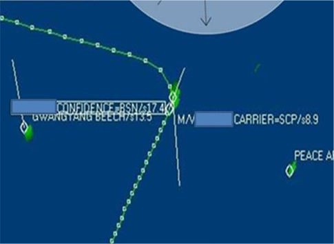
Figures 10 and 11 displays Saenuri’s navigator’s intention transmission screen. Figure 10 is the navigator’s intention transmission screen based on the ship’s own position and two waypoints in front (mothod 1). Figure 11 is a screen based on the ship’s own position and two randomly-selected coordinates (method 2). Figure 12 is Hanbada’s navigator’s intention receipt screen.
For the past three decades, ship-to-ship collision accidents have steadily increased on the coast of South Korea by about 20% annually. Marine accidents have become more likely and more devastating in areas with increasing marine traffic and rising numbers of high-speed ships. Over 30% of the marine accidents in the country are concentrated in spring when Korea’s coast is often covered in dense fog. Fog is generated when large temperature range exists within a day, and this daily temperature range has increased due to abnormal weather conditions.
This research has proposed a system for transmitting a navigator’s intention by utilizing electronic methods. A navigator’s intention was expressed on the electronic navigation chart to facilitate understanding of the surrounding situation and the effectiveness of the system was verified through testing on actual ships.
Continued ship testing will be necessary to further improve the system.

![Collision OO Confidence and OO Carrier [2].](http://oak.go.kr/repository/journal/14508/E1FLA5_2014_v14n2_130_f001.jpg)