검색 전체 메뉴
PDF
맨 위로
OA 학술지
퇴적물 오염기준을 이용한 금강 하구역 표층 퇴적물내 유기물 및 미량금속 오염 평가 Evaluation of Organic Matter and Trace Metal Contamination in Surface Sediments around the Geum River Estuary using Sediment Quality Guidelines
  • 비영리 CC BY-NC
  • 비영리 CC BY-NC
ABSTRACT
퇴적물 오염기준을 이용한 금강 하구역 표층 퇴적물내 유기물 및 미량금속 오염 평가

We evaluated contamination with organic matter and trace metals by analyzing grain size, ignition loss (IL), chemical oxygen demand (COD), acid volatile sulfide (AVS), and trace metals (Al, Fe, Cu, Pb, Zn, Cd, Ni, Cr, Mn, Hg, and As) in surface sediments at 28 stations around the Geum River estuary in July 2008. The surface sediments in the estuary were mainly composed of coarse sediment (sand and muddy sand), with mean grain size (Mz) ranging between 2-4 Ø. The high concentrations of IL, COD, and trace metals were mainly found at stations in front of the Gusan outer port and industrial complex, and near the Seocheon coast with relatively fine sediments. In addition, the concentrations of IL and all trace metals, except Pb and As, showed good positive correlations with Mz, indicating that the concentrations of organic matter and trace metals were mainly dependent on sediment grain size. The concentrations of COD, AVS, and trace metals in most sediments did not exceed the sediment quality guideline (SQGs). Although the sediments in the study region are not polluted with organic matter and trace metals, there are many point sources of pollutants, such as Gusan port and industrial complex, Janghang refinery, and a thermoelectric power plant around the Geum River estuary. Thus, the management of coastal environments through periodic monitoring of organic matter and trace metals is required in the future.

KEYWORD
Sediment , Organic matter , Trace metal , Contamination. Sediment quality guidelines. Geum River estuary
  • 서 론

    하구역은 강물과 해수가 만나는 전이지대로서 강물을 통해 육지에서 공급되는 부유물질과 용존 화학성분들이 물리적인 희석작용, 생물에 의한 흡수, 부유물질에 의한 탈착과 흡착 등과 같은 공급과 제거과정을 통해 급격한 변화를 보이는 곳이다. 특히, 계절적인 강우량의 차이와 하구둑 건설로 인한 강물 유출량의 변화, 지형적인 특성, 해수유동의 변동, 주변 도시하수의 유입과 같은 인간활동의 영향으로 그 변화 양상은 매우 복잡하다(Yang et al., 1999).

    하구 퇴적물은 주로 하천기원 부유물질로 구성되어져 있으며 부유물질의 기원, 운반 및 퇴적과정, 하구역의 환경요인에 따라 그 분포가 달라진다(Seo and Park, 2007). 한반도 서해안의 경우, 연안을 따라 한강, 금강, 만경강, 동진강, 영산강 등과 같은 큰 강이 위치하고 있고 이들 해역의 하구 퇴적물에 있어서 강물로부터 유입되는 부유물질의 영향이 매우 중요할 것으로 여겨지고 있다(Park and Khim, 1990). 이러한 강물을 통해 유입되는 하천기원 부유물질의 분포는 하구 퇴적물중 화학성분들의 분포에도 큰 영향을 줄 수 있다. 특히 미량금속은 반응성으로서 하천기원 부유물질과 함께 강에서 바다로 이동하는 동안 여러가지 물리·화학적 환경 변화에 따른 공급과 제거과정을 거쳐 최종적으로 하구 퇴적물에 침적된다. 따라서, 하구 퇴적물중 미량금속은 그 해역의 미량금속 오염 정도에 대한 지표로 사용될 수 있다(Bruland et al., 1974; Förstner and Wittman, 1979).

    한반도 중부에 위치한 금강은 우리나라의 5대강에 속하는 큰 강으로 인근의 만경강과 동진강과 더불어 한반도 서해 중부 연안해역에 다량의 퇴적물을 공급하는 중요한 하천중에 하나이다(Choi et al., 1995a). 하지만, 매년 발생하는 가뭄과 홍수의 폐해, 염수의 침입을 방지하기 위하여 1988년 전라북도 옥구군 성산면 성덕리와 충청남도 서천군 마서면 도삼리를 연결하는 금강 하구둑(길이 : 1,841 m)이 건설되었고(Yang et al., 1999; Seo and Park, 2007), 하구 인근 해역에 새만금 간척사업, 군산 신외항 및 해상도시 건설 등 대규모 방조제 축조와 매립사업이 완료되었거나 수행중에 있다(Ryu et al., 2006). 또한, 하구둑에서부터 바다쪽으로 군산내항, 장항항, 군산외항이 위치하고 있으며(Shin et al., 2006), 매립지와 인근 육상에는 공단이 조성되어 비료 및 제조 공장, 동판가공 공장, 제지·펄프 공장, 조선소 등 각종 산업시설들이 들어서고 있다. 이러한 금강하구 주변의 개발은 연안지역의 산업화와 도시화를 가속화하여 육상으로부터 미량금속의 유입을 가중시키고 금강 하구역을 비롯한 인근해역에 확산되어 퇴적물 오염을 일으킬 가능성이 높다. 특히, 금강 하구 서천군 장항 인근 육상에는 1936년부터 50여년 동안 제련 활동이 있었던 장항제련소가 위치하고 있으며(Kim and Chon, 1993), 제련과정에서 발생한 미량금속들이 분진이나 폐수를 통하여 배출되어 주변 토양과 하구 퇴적물의 오염원으로 작용하였을지 모른다.

    지금까지 금강 하구역과 인근 해역에서 미량금속의 지화학적 순환과정을 이해하기 위하여 금강주변 육상 토양(Kim and Chon, 1993), 하천수 및 하천기원 부유물질(Lee, 1992; Choi, 1993a; Ra, 1993; Choi et al., 1995a, 1996; Kim, 2002; Youn, 2013), 하상 퇴적물(Choi et al., 1996; Hwang et al., 2001; Kang, 2009; Park, 2013), 하구 퇴적물(Chi et al., 2000; Seo and Park, 2007)중 미량금속 분포특성 및 육상지질과의 상관성에 대하여 지속적인 연구가 진행되어져 왔다. 그러나, 금강 본류를 따라 하천기원 부유물질과 하상 퇴적물중 미량금속의 거동에 대한 연구는 많이 이루어져 왔지만 강물을 통해 유입되는 미량금속의 영향을 받는 하구 퇴적물중 미량금속의 분포 및 오염 현황을 파악할 수 있는 연구는 매우 미비한 실정이다.

    따라서, 이 연구에서는 금강하구 퇴적물중 미량금속의 분포 특성 및 오염현황을 파악하기 위하여 하구둑에서부터 군산외항 바깥쪽 인근해역까지 하구 퇴적물을 채취하여 퇴적물중 미량금속 농도와 이들의 분포에 영향을 줄 수 있는 여러 지화학적인 요인들(입도, 강열감량, 화학적산소요구량, 산휘발성황화물)을 조사하였다.

    재료 및 방법

      >  연구지역

    연구지역인 금강하구는 한반도 서쪽 중앙부의 충청남도 서천과 전라북도 군산의 경계부근에 위치하고 있다(Fig. 1). 금강은 발원지인 전라북도 진안에서 군산까지 총 연장 412 km, 유역면적이 약 9,900 km2에 달하는 큰 강이다(Yang et al., 1999). 연평균 강물 유출량은 약 6.4×10⁹ m3/year에 달하며 한반도 중부지방의 농공업용수와 주변 도시의 상수원으로서 이용되고 있다(Yang and Kim, 1990; Kim et al., 1998). 또한, 강물을 통해 하구로 유출되는 부유물의 양은 연간 약 1.0-1.5×10⁶ m3/year에 이른다(Choi, 1993b; Choi et al., 1995b). 강의 하류쪽에 건설된 하구둑과 몬순기후의 영향으로 강물과 이를 통한 부유물 유출량의 시간적 변화가 매우 크고, 하계에 집중적으로 공급되는 부유물질의 대부분은 하구둑 건설로 인한 하구지형 및 해수유동의 변화로 군산외항에서부터 하구둑까지 부유물질의 퇴적이 우세한 환경으로 바뀌면서 군산내항까지 선박의 입·출항을 위해 주기적인 준설이 이루어지고 있다(Choi, 1993b; Choi et al., 1995b; Shin et al., 2006).

    금강하구는 복잡한 지형 및 천해특성에 기인한 조석현상이 뚜렷하게 나타나며, 강물 유출량에 비하여 상대적으로 조석의 영향이 우세한 해역이다(Shin et al., 2006, Seo and Park, 2007). 이 해역의 조석은 일조부등인 반일주조로 군산내항을 기준으로 평균조차가 4.3 m (대조기 5.7 m, 소조기 2.8 m)로서 대조차 환경을 보인다(Choi et al., 1989; Lee, 1992). 이로 인해 강물 유출시 완전혼합형 또는 부분혼합형의 순환형태를 갖는 염하구 환경이 발달하고, 강물 유출량이 적은 시기에는 최대 혼탁수(turbidity maximum)가 형성된다(Choi et al., 1996). 조석의 방향은 북동-남서 방향이 우세하며 최강유속은 2 m/sec 이상이다(Choi, 1993b).

    강한 조석현상에 의해 하구역내에 대규모 조석사주인 대죽사주가 발달하여 금강 본류의 담수는 장항쪽의 북수로와 군산쪽의 남수로로 양분되어 해양으로 유입된다(Choi, 1993b). 또한, 군산외항 개발로 인해 군산쪽의 갯벌이 상당히 감소하였지만 서천 장항쪽으로 넓은 갯벌이 발달해 있으며 특히, 군산외항 앞쪽 유부도 및 서천 연안 갯벌은 2008년 연안 습지보호지역(coastal wetland protected area)으로 지정되어 정부에서 지속적인 관리가 이루어지고 있다(http://www.tidalfl at.go.kr). 유역의 지질은 주로 선캄브리아기의 변성암 복합체와 중생대 화강암체로 구성되어져 있으며 옥천대의 변성퇴적암도 금강을 따라 넓게 분포하고 있다(Choi et al., 1996).

      >  시료채취 및 분석방법

    금강하구 퇴적물중 미량금속의 분포특성 및 오염현황을 파악하기 위하여 2008년 7월 국립수산과학원 탐구18호를 이용하여 하구둑에서부터 군산외항 바깥쪽 서천-고군산군도 인근해역까지 총 28개 정점에서 채니기(van Veen grab sampler)로 표층(0-2 cm) 퇴적물을 채취하였다(Fig. 1). 채취한 시료는 미리 산 세척한 고밀도 폴리에틸렌병(high density polyethylene bottle)에 담아 냉동상태로 실험실로 운반하여 입도(grain size)와 강열감량(ignition loss, IL), 화학적산소요구량(chemical oxygen demand, COD), 산휘발성황화물(acid volatile sulfi de, AVS) 및 미량금속(Al, Fe, Cu, Pb, Zn, Cd, Ni, Cr, Mn, Hg, and As)을 Hwang et al. (2011)이 실시한 동일한 방법으로 분석하였다. 분석방법을 간략히 설명하면, 입도는 Ingram (1971)의 표준 입도 분석 방법에 따라 유기물과 탄산염을 제거한 퇴적물을 4Ø 표준체로 물체질을 하여 조립질과 세립질 퇴적물을 분리한 다음 조립질 퇴적물은 진탕기(Ro-tap sieve shaker, Fritsch, Model-Analysette 3)를 이용하여 건식체질(dry sieving)을, 세립질 퇴적물은 피펫팅법으로 처리한후 무게를 측정하여 퇴적물 조성을 알아내었고 Folk and Ward (1957)의 계산식으로 평균입도(mean grain size, Mz)를 구하였으며 Folk (1968)의 삼각좌표를 이용하여 퇴적상을 분류하였다. IL은 퇴적물의 회화 전후의 무게차이로, COD는 알카리성 과망간산칼륨(KMnO4)법, AVS는 황화수소 검지관법으로 분석하였다. 미량금속은 퇴적물을 동결건조한 후 플라스틱 재질의 체(Ø< 63 μm)를 이용하여 체를 통과한 퇴적물을 회수하여 혼합산(HNO3:HF:HClO4= 2:2:1)을 이용한 완전분해법으로 퇴적물을 용해한 다음 2% 질산(HNO3)으로 정용한 후 수은을 제외한 미량금속은 유도결합플라즈마 질량분석기(ICP-MS, Perkin Elmer, Model-Elan 9000)로 분석하였다. 수은의 경우에는 동결건조한 퇴적물 시료를 직접 수은자동분석기(Mercury analyzer, Milestone, Model DMA-80)로 분석하였다. 이때, 미량금속 자료의 신뢰성을 확보하기 위하여 인증표준물질을 시료와 함께 분석하였고, 인증 표준물질(certifi ed reference material)로는 MESS-3 (marine sediment, NRC)를 이용하였다. 각 미량금속의 회수율은 Al 97%, Fe 104%, Cu 105%, Pb 105%, Zn 94%, Cd 104%, Ni 106%, Cr 98%, Mn 99%, Hg 100%, As 106%로서 90-110% 사이 범위였다.

    결과 및 고찰

      >  하구 퇴적물의 조성 및 분포

    퇴적물의 입도는 퇴적학적 관점에서 퇴적지 부근의 파도, 조석 등과 같은 해수의 수리·역학적 해양환경특성을 반영하는 중요한 인자이며(Lee et al., 2004), 퇴적물중 유기물과 미량금속의 농도분포를 조절하는 요인중에 하나이다(Cho et al., 2001; Hwang and Kim, 2011) . 따라서, 하구역과 같이 강물의 유출과 조석에 따른 해수 유동의 변화에 의한 물리화학적 해양환경이 급격하게 변화하는 해역에서 유기물 및 미량금속의 농도분포와 오염을 평가하기 위해서는 무엇보다 퇴적물의 입도조성 및 분포를 파악할 필요가 있다.

    금강하구 퇴적물중 자갈, 모래, 실트, 점토 함량은 각각 0.0-3.0% (평균 0.3±0.8%), 21.5-98.9% (평균 77.3±23.5%), 0.4-59.7% (평균 14.3±16.1%), 0.6-25.7% (평균 8.1±7.7%) 범위였다. 자갈은 개야도 인근 St. 10과 금강하구 입구쪽의 St. 12에서 약 3%의 조성을 보일 뿐 그외 정점에서는 나타나지 않았으며, 실트와 점토의 함량이 50% 이상을 보인 군산외항과 산업단지 앞쪽의 St. 6-8, 개야도 인근의 St. 10과 서천 연안쪽의 St. 26 정점을 제외한 거의 모든 정점에서 모래가 약 70% 이상으로 가장 높은 함량을 나타내었다. 각 정점별 퇴적물 조성을 기초로 Folk (1968)의 삼각좌표에 표시한 결과 총 8개의 퇴적물 유형(sedimentary type)으로 분류되었다. 연구해역내 퇴적물 분포를 살펴보면, St. 8 은 사질실트(sandy silt, sZ), St. 6와 St.26은 사질니(sandy mud, sM), St. 7와 St. 10 은 약역질니[slightly gravely mud, (g)M], St. 5와 St.16 은 약역질사[slightly gravelly sand, (g)S], St. 1와 St. 12는 약역니질사[slightly gravelly muddy sand, (g)mS], St. 14와 St. 19는 실트질사(silty sand, zS), St. 2, 4, 15, 18, 24, 25, 27은 니질사(muddy sand, mS)였고 그외 나머지 정점들은 모두 사(sand, S) 퇴적물로 이루어져 있었다(Fig. 2). 하구둑 부근의 정점들은 니가 함유된 사질 퇴적물(mS), 새만금 방조제 앞쪽에 실트가 함유된 사질 퇴적물(zS), 군산산업단지 바깥쪽 해역의 정점들에서는 사퇴적물(S)이 우세하게 분포하여 전반적으로 조립질의 사퇴적물이 연구해역내 넓게 분포하는 것으로 나타났다. 하지만, 군산외항 및 산업단지와 도류제 사이의 수로내 정점들에서는 다른 해역과 달리 상대적으로 세립한 니질 퇴적물[sZ, sM, (g)M]이 분포하였다. 이는 하구둑 건설 및 산업단지 북쪽으로 유부도에서부터 외해역으로 도류제 설치로 인하여 이 해역내 조류의 유속이 현저히 감소함으로서 세립질 퇴적물이 퇴적되었기 때문인 것으로 생각된다. 이전에 Choi et al. (2002)은 금강 하구둑 건설에 따른 해수유동의 변화로 인해 연구해역의 St. 5과 St. 9 사이에서 강물과 해수가 만나 급격한 염분 변화를 보이는 염분전선이 형성된다고 하였으며, Choi et al. (1995b)은 하구언 갑문 폐쇄이후 저에너지의 환경조건으로 변하여 금강 하구역에 육상에서 바다쪽으로 공급·운반되는 세립질 부유물질의 지속적인 퇴적이 일어날 것으로 보고하였다. 퇴적물의 Mz는 1.7-7.0Ø (평균 3.6±1.4Ø) 범위였으며, 실트와 점토의 함량이 높았던 군산외항과 산업단지 앞쪽, 서천 연안쪽의 일부 정점을 제외하면 대부분이 2-4Ø로 중립사(medium sand)와 극세립사(very fi ne sand) 사이였다(Fig. 3).

      >  하구 퇴적물중 유기물 함량 및 오염현황

    해저 퇴적물중 유기물량은 퇴적환경 특성 및 오염을 평가하는 중요한 척도중에 하나이다. 연구해역내 퇴적물중 유기물 분포특성을 파악하기 위하여 표층 퇴적물중 IL함량을 Fig. 3에 나타 내었다. 퇴적물 중 IL은 0.8-5.4% (평균 1.9±1.1%) 범위였으며 서천 연안의 St. 26에서 가장 높고 장항 제련소 앞쪽의 St. 3에서 가장 낮았다. 전반적으로 대부분이 2.0% 이하의 낮은 IL농도를 보였으나 상대적으로 실트와 점토 함량이 높은 군산외항과 산업단지 앞쪽 수로부근의 St. 6-8, 개야도 인근의 St. 10, 연도 부근의 St. 15, 서천 연안쪽의 St. 26 에서 3.0% 이상으로 다른 정점들에 비해 높은 농도를 보였다. 이는 연구해역내 퇴적물의 평균입도와 IL의 농도 사이에 좋은 양의 상관성(r = 0.95)을 보인다는 사실에 비추어 볼 때(Fig. 4), 퇴적물중 유기물 함량이 입도와 밀접한 관련이 있으며 이들에 의해 분포양상이 달라지는 것으로 생각된다.

    퇴적물중 COD와 AVS는 퇴적물내 유기물 오염 및 건강도를 평가하는 기준으로서 널리 이용되어져 왔으며(Yoon, 2000; Hyun et al., 2003, 2004), 이 연구에서도 퇴적물중 유기물 오염을 평가하기 위하여 COD와 AVS 농도를 이용하였다. 연구해역내 COD와 AVS 농도는 각각 1.2-13.0 mgO2/g·dry (평균 4.4±3.3 mgO2/g·dry), 불검출-0.70 mgS/g·dry (평균 0.006±0.049 mgS/g·dry)범위였다(Fig. 3). COD의 경우 군산외항 앞쪽의 St. 6에서 가장 높고 인접한 St. 5에서 가장 낮았다. 전반적으로 IL 함량이 높았던 군산내항 앞쪽의 St. 1, 군산외항과 산업단지 앞쪽 수로부근의 St. 6-8, 개야도 인근의 St. 10, 연도 부근의 St. 15, 산업단지 바깥쪽의 St. 18과 St. 24, 서천 연안쪽의 St. 26 에서 7.0 mgO2/g·dry이상으로 다른 정점들에 비해 COD 농도가 높았다. AVS의 경우에는 가장 높은 COD 농도를 보였던 군산외항 앞쪽의 St. 6에서 가장 높았으며 산업단지 앞쪽의 일부 정점을 제외한 거의 모든 정점에서 검출되지 않거나 0.005 mgS/g·dry 이하의 낮은 농도를 나타내었다.

    한편, 우리나라의 해양환경기준중 퇴적물내 COD와 AVS에 대한 기준이 없어 이 연구에서는 연구해역의 퇴적물중 유기물 오염 정도를 파악하기 위하여 일본의 퇴적물 기준을 적용하였다. 일본에서 수산생물의 보호를 위하여 생물에 영향을 주는 기준농도로서 COD와 AVS에 대하여 각가 20 mgO2/g·dry과 0.2mgS/g·dry를 설정해 놓고 있다(Yokoyama, 2000). 이 기준을 적용하였을 때, 연구해역내 퇴적물 중 COD는 모든 정점에서 일본의 퇴적물 기준보다 낮았으며 대부분의 정점에서 1/3이하의 낮은 농도 수준이었다. AVS 또한 군산내항 인근의 St. 2과 군산외항과 산업단지 앞쪽 수로의 St. 6-7에서 일본의 퇴적물 기준을 초과하는 것으로 나타났으나 대부분의 정점에서 1/50이하의 낮은 농도를 수준을 보였다. 또한, 연구해역의 IL, COD,AVS 농도를 이전의 연구결과와 비교해 보면(Table 1), 연구해역 인근의 변산반도(Jung et al., 2010)와 새만금 안쪽(Kim et al., 2003) 조간대 퇴적물에서 측정된 IL, COD, AVS 농도보다는 비슷하거나 다소 높았으나, 우리나라의 대표적인 항만인 부산항(Park et al., 1995)과 마산항(Hwang et al., 2006), 그리고 양식활동이 활발한 반폐쇄적인 내만인 득량만(Yoon, 2003), 여자만(Hue et al., 2000), 가막만(Noh et al., 2006), 함평만(Hwang and Koh, 2012) 보다는 낮았다. 따라서, 연구해역인 금강하구 퇴적물은 유기물에 대하여 우려할 만큼 오염이 진행되지 않은 것으로 생각된다.

    [Table 1.] The content of ignition loss (IL) and the concentrations of chemical oxygen demand and acid volatile sulfi de (AVS) in surface sediment around Geum River estuary. The parenthesis represents the average of each paramenter in surface sediment

    label

    The content of ignition loss (IL) and the concentrations of chemical oxygen demand and acid volatile sulfi de (AVS) in surface sediment around Geum River estuary. The parenthesis represents the average of each paramenter in surface sediment

      >  하구 퇴적물중 미량금속 함량 및 오염현황

    연구해역내 퇴적물중 미량금속 분포특성을 파악하기 위하여 표층 퇴적물중 각 정점별 미량금속 농도를 Fig. 5에 나타내었다. 퇴적물중 미량금속은 알루미늄(Al)은 4.4-9.5% (평균 6.4±1.4%), 철(Fe)은 1.7-5.1% (평균 2.7±0.9%), 망간(Mn)은 260-1,020 mg/kg (평균 467±167 mg/kg), 아연(Zn)은 23-106 mg/kg (평균 49±26 mg/kg), 크롬(Cr)은 21.6-89.2 mg/kg (평균 45.1±9.1 mg/kg), 니켈(Ni)은 7.8-41.4 mg/kg(평균16.5±9.1 mg/kg), 구리(Cu)는 2.8-24.7 mg/kg (평균 9.5±7.3mg/kg), 납(Pb)은 19.7-32.8 mg/kg (평균 26.5±3.4 mg/kg), 비소(As)는 3.4-12.4 mg/kg (평균 7.3±2.9 mg/kg), 카드뮴(Cd)은 0.06-0.28 mg/kg (평균 0.12±0.05 mg/kg), 수은(Hg)은 0.003-0.048 mg/kg (평균 0.013±0.011 mg/kg) 범위였으며 평균농도를 기준으로 Al > Fe > Mn > Zn > Cr > Pb > Ni > Cu >As >Cd > Hg 순으로 높은 농도를 나타내었다. IL과 유사하게 거의 모든 미량금속들이 상대적으로 점토와 실트 함량이 높았던 군산외항과 산업단지 앞쪽 수로 부근, 개야도 인근, 서천 연안의 일부 정점들에서 다른 정점들에 비해 2배 이상 높은 농도를 보였다(Fig. 6). 특히, Pb과 As를 제외한 모든 미량금속들이 Mz와 좋은 양의 상관성을 보였다(r =0.55-0.91; Fig. 4). 일반적으로 연안해역에서 퇴적물중 금속원소의 농도는 주로 퇴적물의 입도와 쇄설성 광물의 영향을 크게 받는 것으로 알려져 있으며 (Cho and Park, 1998; Cho et al., 2001; Hwang et al., 2010), 이전에 Choi et al. (1996)은 금강 하천 퇴적물중 미량금속 함량이 평균입도와 밀접한 관련이 있고, 다른 금속과 달리 Pb은 조립질 모래에서 높은 농도를 보이는데 이는 모래에 많이 함유된 정장석에 의한 영향 때문이라고 보고하였다. 또한 금강유역 주변에 넓게 분포하고 있는 옥천대의 변성퇴적암류에는 황철석, 황동석, 유비철석 등 황화 광석광물들을 포함하고 있어 높은 비소 함 량을 보인다(Chon et al., 2009). 따라서, 연구해역내 퇴적물중 미량금속의 농도분포는 유기물과 마찬가지로 퇴적물내 입도의 영향을 받고 있으나 Pb과 As의 경우에는 퇴적물내 암석물질 중금속함량과 밀접한 관련이 있는 것으로 생각된다. 한편, 연구 해역내 퇴적물중 미량금속 농도는 이전에 Choi et al. (1995a)이 측정한 금강 부유물질중 미량금속 농도(Al 9.7%, Fe, 5.2%, Mn 6,700 mg/kg, Cu 54 mg/kg, Pb 79 mg/kg, Zn 327 mg/kg, Cd 0.85 mg/kg, Cr 98 mg/kg, Ni 58 mg/kg)보다 낮았다.

    일반적으로 퇴적물내 금속원소의 오염에 대한 평가는 주로 각 나라별로 설정해 놓은 금속원소의 오염기준(sediment quality guidelines; SQGs)이나 혹은 분석된 금속원소의 농도를 지각물질 중의 자연적인 배경농도와 연구해역의 오염되지 않은 퇴적물중의 미량금속 농도를 이용하여 수치적으로 환산한 값을 비교하는 농축계수(enrichment factor)와 농집지수(geoaccumulation index), 농축부화비(cocnetration enrichment ratios), 오염지수(contamination index) 등 다양한 방법이 있다(Bruland et al., 1974; Müller, 1979; Prusty et al., 1994; Sutherland, 2000; Hong et al., 2007). 이중에서 지금까지 한반도 연안 퇴적물의 오염평가에 있어서 농축계수와 농집지수를 이용한 많은 연구가 진행되어져 왔으며(Shin et al., 2002; Hyun et al., 2003; Hwang et al., 2006; Hyun et al., 2007; Lee et al., 2008; Jeon et al., 2012; Kim et al., 2012), 일부 연구자들은 미국 해양대기청(National Oceanic and Atmospheric Administration, NOAA) 에서 권고하는 퇴적물 기준을 이용하여 오염을 평가하기도 하였다(Kim et al., 2008; Hwang et al., 2010; Hwang and Kim, 2011). 이는 그 동안 우리나라의 퇴적물 오염현황을 파악하기 위한 퇴적물 기준이 설정되어 있지 않았기 때문이다.

    최근 해양수산부에서는 우리나라의 지질특성 및 생물영향을 고려한 연안 퇴적물 오염을 판단할수 있는 미량금속 기준을 제시하였다(http://www.mof.go.kr). 하지만, 외국의 퇴적물 오염기준과 달리 이 기준에서 미량금속중 Cu와 Zn은 퇴적물중 Li을 이용하여 입도의 영향을 보정한 농도를 산출하여 기준값과 비교할 것을 권고하고 있다. 그러나, 이 연구의 경우 퇴적물 기준을 설정하기 이전에 조사가 이루어져 Li의 분석결과가 없기 때문에 현재로서는 연구해역내 퇴적물중 Cu와 Zn의 오염평가가 불가능하다. 따라서, 이 연구에서는 연구해역내 퇴적물중 미량금속 농도가 퇴적물에 서식하는 저서생물 및 유용수산생물에 어느 정도 영향을 주는지 알아보기 위하여 기존의 다른 연구자들이 이용해온 미국 NOAA의 퇴적물 권고기준인 ERL (effect range low) 값(Buchman, 2008)과 최근에 해양수산부에서 설정한 퇴적물의 미량금속 오염기준중 주의기준(threshold effects level, TEL) 값을 함께 이용하여 미량금속의 오염현황을 살펴 보았다.

    먼저, 미국 NOAA에서 퇴적물 오염평가시 적용하는 ERL은 지각물질중에 풍부하게 존재하는 Al과 Fe를 제외한 총 9개의 미량금속에 대하여 기준 농도(Cu 34 mg/kg, Pb 46.7 mg/kg, Zn 150 mg/kg, Cd 1.2 mg/kg, Cr 81 mg/kg, Ni 20.9 mg/kg, As 8.2 mg/kg, Hg 0.15 mg/kg, Ag 1.0 mg/kg)를 제시하고 있다. 이는 퇴적물중 미량금속 농도가 이들 ERL값을 초과할 경우 서식생물에 악영향을 줄 가능성이 있음을 의미한다. 따라서, 이 기준값과 연구해역내 퇴적물중 미량금속 농도와 비교해 보면(Fig. 5), Cr은 개야도 인근의 St. 10과 서천 연안의 St. 26 에서, Ni은 군산외항과 산업단지 앞쪽 수로 부근의 St. 6-8, 개야도 인근의 St. 10, 서천 연안의 St. 26과 St. 27에서, As는 군산내항에서부터 군산외항 사이의 St. 2-5, 군산 산업단지 앞쪽의 St. 8, 군산 산업단지 바깥쪽의 St. 22와 St. 24, 서천 연안의 St. 25-27 에서 ERL 값을 초과하였다. 하지만, 그외 다른 정점들은 ERL 값 미만이었으며, Cu, Pb, Zn, Cd, Hg의 경우 모든 정점에서 ERL 값 미만이었다.

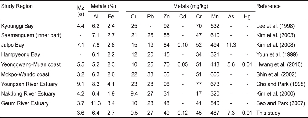
    해양수산부(고시 제2013-186호)에서는 제시한 연안 퇴적물 오염 기준인 TEL은 NOAA와 유사하게 지각물질중에 풍부하게 존재하는 Al과 Fe를 제외한 총 8개의 미량금속에 대하여 기준 농도(Cu 20.6 mg/kg, Pb 44.0 mg/kg, Zn 68.4 mg/kg, Cd 0.75 mg/kg, Cr 116 mg/kg, Ni 47.2 mg/kg, As 14.5 mg/kg, Hg 0.11 mg/kg)를 제시하고 있다(http://www.mof.go.kr). 이 TEL 기준값은 미국 NOAA의 ERL값에 비해 Cu, Pb, Zn, Cd, Hg은 좀더 엄격하게 강화된 반면, Cr, Ni, As는 완화된 수치이며, 이 값을 초과하는 미량금속을 함유한 퇴적물은 부정적인 생태영향이 발현될 가능성이 높음을 의미한다. 앞서 설명하였듯이, 이 연구에서는 퇴적물중 Cu, Zn의 오염 평가가 불가능 하기 때문에 이들을 제외한 미량금속들에 대해서만 오염평가를 실시하였다. 그 결과(Fig. 5), 앞서 ERL 평가와 달리 연구해역내 퇴적물 중 모든 미량금속들은 TEL 값보다 낮았다. 또한, 이전에 보고된 서해 연안과 낙동강하구 퇴적물중 미량금속 농도와 비교해 보았을 때(Table 2), Seo and Park (2007)이 금강 하구둑에서부터 군산 산업단지 바깥쪽 외해까지 조사한 하구 퇴적물중 미량 금속 농도와 유사하고, 비슷한 해양환경 특성을 보이는 낙동강 하구(Kim et al., 2000) 퇴적물 보다는 비슷하거나 다소 높았다. 하지만, 한강하류의 경기만(Lee et al., 1998) 조하대 퇴적물과 연구해역 인근의 새만금 안쪽(Kim et al., 2003)과 줄포만(Kim et al., 2008), 남서해안의 영광-무안 연안(Hwang et al., 2010) 과 목포-완도 연안(Shin et al., 2002) 조간대 퇴적물에서 조사된 미량금속 농도보다 낮은 농도였다.

    [Table 2.] The mean grain size (Mz) and the average concentrations of trace metals (Al, Fe, Cu, Pb, Zn, Cd, Cr, Mn, As, and Hg) in coastal sediment of Korea

    label

    The mean grain size (Mz) and the average concentrations of trace metals (Al, Fe, Cu, Pb, Zn, Cd, Cr, Mn, As, and Hg) in coastal sediment of Korea

    이상의 결과를 보았을 때, 금강하구 퇴적물의 경우 유기물과 마찬가지로 모든 미량금속에 대하여 오염되지 않은 상태인 것으로 나타났다. 그러나, 미량금속 함량 및 분포를 보았을 때, 군산외항과 산업단지 앞쪽 수로와 개야도, 연도 및 서천연안 일부 해역의 퇴적물에서 미량금속 농도가 다소 높고, 비록 국내 기준 보다는 낮지만 외국 기준중 Cr, Ni, As이 기준값을 초과하는 것으로 나타났다. 특히 이들 해역의 경우 주변에 항만, 산업단지, 장항제련소, 양식장 등 많은 미량금속 오염원이 존재하고 있어 대기와 주변 하천을 통한 지속적인 미량금속 유입 가능성이 높다. 또한, 다른 해역보다 세립질 퇴적물로 이루어져 있어 앞으로 미량금속이 유입될 경우 퇴적물에 축적되어 오염될지 모른다. 따라서, 앞으로 이들 해역에서 유기물과 미량금속과 같은 오염물질의 현황을 확인할 수 있는 대한 주기적인 모니터링과 같은 체계적인 환경관리체제를 구축하여 관리할 필요가 있다.

참고문헌
  • 1. Bruland KW, Bertine K, Koide M, Goldberg ED 1974 His­tory of metal pollution in southern California coastal zone [Environ Sci Technol] Vol.8 P.425-432 google cross ref
  • 2. Buchman MF 2008 NOAA screening quick reference tables P.34 google
  • 3. Chi JM, Jang YH, Oh JK, Lee YH 2000 Geochemical relationship between shore sediments and land geology in Keum River area west coast of Korea [Econ Environ Geol] Vol.33 P.447-467 google
  • 4. Cho YG, Park KY. 1998 Heavy metals in surface sediments of the Youngsan estuary west coast of Korea [J Kor Environ Sci Soc] Vol.7 P.549-557 google
  • 5. Cho YG, Ryu SO, Khu YK, Kim JY 2001 Geochemical composition of surface sediments from the Saemangeum tidal flat west coast of Korea [J Kor Soc Oceanogr] Vol.6 P.27-34 google
  • 6. Choi BH, Kang KG, Lee SW 1989 Tide and sediment transport in the Keum River estuary [J Kor Soc Coast Ocean Engin] Vol.1 P.31-43 google
  • 7. Choi JY. 1993 Seasonal variations of suspended matters in the Keum estuary and its adjacent coastal area [J Oceanol Soc Kor] Vol.28 P.272-280 google
  • 8. Choi JY, Choi HY, Seo MS 1995 Physical and sedimen­tological changes in the Keum estuary after the gate-close of Keum River weir [J Kor Soc Oceanogr] Vol.30 P.262-270 google
  • 9. Choi MS, Lee CB, Cho YG 1995 Trace metals of sus­pended particulate matters in the Keum River [J Kor Soc Oceanogr] Vol.30 P.371-381 google
  • 10. Choi MS, Lee SH, Lee CB, Cho YG 1996 Trace metal in sediments of Keum River [Kor J Quarter Res] Vol.10 P.27-52 google
  • 11. Choi YK, Yang WS, Jeong JY 2002 Nutrient front relating to the hydrography in the outflow region of the Keum River [J Kor Fish Soc] Vol.35 P.289-296 google
  • 12. Choi YG 1993 A survey on the water quality and the heavy metal content of the fish, shellfish, moss and soil in Kum River. Master Dissertation google
  • 13. Chon CM, Kim KY, Koh DC, Choi MJ 2009 Arsenic dis­tribution and solubility in groundwater of Okcheon Area [J Miner Soc Kor] Vol.22 P.331-342 google
  • 14. Folk RL. 1968 Petrology of sedimentary rock P.170 google
  • 15. Folk RL, Ward WC. 1957 Brazos river bar: A study in the significance of grain size parameters [J Sed Petol] Vol.27 P.3-26 google cross ref
  • 16. Forstner U, Wittman GTW 1979 Metal pollution in the aquatic environment P.486 google
  • 17. Ingram RL, Carver RE 1971 Sieve analysis P.49-67 google
  • 18. Hong JT, Na BS, Kim JY, Koh YK, Youn ST, Shin SE, Kim HG, Moon BC, Oh KH 2007 Sedimentary geochemi­cal characteristics and environmental impact of sediments in Tamjin River and Doam Bay [J Environ Impact Assess] Vol.16 P.393-405 google
  • 19. Hue HK, Kim DH, Ahn SH, Park KW 2000 Characteristics of the sedimentary environment in Yoja Bay in the summer of 1998 [Kor J Environ Biol] Vol.18 P.227-235 google
  • 20. Hwang DW, Jin HG, Kim SS, Kim JD, Park JS, Kim SG 2006 Distribution of organic matters and metallic elements in the surface sediments of Masan Harbor, Korea [J Kor Fish Soc] Vol.39 P.106-117 google
  • 21. Hwang DW, Kim SG 2011 Evaluation of heavy metal con­tamination in intertidal surface sediments of coastal islands in the western part of Jellanam province using geochemical assessment techniques [Kor J Fish Aquat Sci] Vol.44 P.772-784 google
  • 22. Hwang DW, Koh BS 2012 Sedimentary and benthic en­vironment characteristics in macroalgal habitats of the in­tertidal zone in Hampyeong Bay [Kor J Fish Aquat Sci] Vol.45 P.694-703 google cross ref
  • 23. Hwang DW, Park SE, Kim PJ, Koh BS, Choi HG 2011 Assessment of the pollution levels of organic matter and me­tallic elements in the intertidal surface sediment of Aphae Island [Kor J Fish Auat Sci] Vol.44 P.759-771 google
  • 24. Hwang DW, Ryu SO, Kim SG, Choi OI, Kim SS, Koh BS 2010 Geochemical characteristics of intertidal surface sedi­ments along the southwestern coast of Korea [Kor J Fish Aquat Sci] Vol.43 P.146-158 google
  • 25. Hwang JY, Chung WS, Chung YS 2001 Phosphorus and metal content in the sediment from Daecheong and Keum-River estuary reservoirs [J Kor Soc Environ Anal] Vol.4 P.85-91 google
  • 26. Hyun S, Choi JW, Choi JS, Lee T 2003 Surface sediment characteristics and benthic environments in the mouth of Ji­hhae Bay, Korea [J Kor Fish Soc] Vol.36 P.700-707 google
  • 27. Hyun S, Lee CH, Lee T, Choi JW 2007 Anthropogenic con­tributions to heavy metal distributions in the surface sedi­ments of Masan Bay, Korea [Mar Pollut Bull] Vol.54 P.1031-1071 google cross ref
  • 28. Hyun S, Paeng WH, Lee T 2004 Characteristics of surficial sediment and benthic environments based on geochemical data in Gwangyang Bay, Korea [Kor J Environ Biol] Vol.22 P.93-102 google
  • 29. Jeon SB, Kim PJ, Kim SS, Ju JS, Lee YH, Jang DS, Lee JU, Park SY 2012 Characteristics of spatial distribution of geo­chemical components in the surface sediments of the Deu­kryang Bay [J Kor Soc Environ Anal] Vol.15 P.203-214 google
  • 30. Jung RH, Hwang DW, Kim YG, Koh BS, Song JH, Choi HG 2010 Temporal variations in the sedimentation rate and benthic environment of intertidal surface sediments around Byeonsan Peninsula Korea [Kor J Fish Aquat Sci] Vol.43 P.723-734 google
  • 31. Jung RH, Hwang DW, Kim YG, Koh BS, Song JH, Choi HG. 2010 Temporal variations in the sedimentation rate and benthic environment of intertidal surface sediments around Byeonsan Peninsula, Korea [Kor J Fish Aquat Sci] Vol.43 P.723-734 google
  • 32. Kang HG 2009 Studies on the distributions and correlations of mercury, methylmercury, and heavy metal in Guem Riv­er basin sediments. Master Dissertation google
  • 33. Kim BH 2002 Distributions of dissolved and particulate frac­tions of heavy metals (Al, Cd, Cu, Fe, Mn, Ni, Pb, Zn) in seawater, Keum River estuary, Korea. Master Dissertation google
  • 34. Kim JG, You SJ, Ahn WS 2008 Evaluation of characteris­tics of particle compostion and pollution of heavy metals for tidal flat sediments in the Julpo Bay, Korea [J Kor Soc Mar Environ Safety] Vol.14 P.247-256 google
  • 35. Kim JG, You SJ, Cho EI, Ahn WS 2003 Distribution char­acteristics of heavy metals for tidal flat sediments in the Sae­mankeum area [J Kor Fish Soc] Vol.36 P.55-61 google
  • 36. Kim JG, You SJ, Kwon JN 1998 Variations of water quality after construction of Keum River estuary barrage [J Kor Fish Soc] Vol.31 P.685-694 google
  • 37. Kim JY, Chon HT 1993 Geochemical dispersion of Cu, Pb, Zn, and Cd and their mode of occurrences in soils and dusts in Changhang smelter area [Jour Kor Inst Mining Geol] Vol.26 P.175-185 google
  • 38. Kim KH, Cho JH, Park NJ 2000 Distributions and pollu­tion history of heavy metals in Nakdong estuary sediments [J Kor Soc Oceanogr] Vol.5 P.285-294 google
  • 39. Kim PJ, Shon SG, Park SY, Kim SS, Jang SJ, Jeon SB, Ju JS 2012 Biogeochemistry of metal and nonmetal elements in the surface sediment of the Gamak Bay [J Kor Soc Mar Environ Safety] Vol.18 P.67-83 google cross ref
  • 40. Lee CB. 1992 The behavior of dissolved iron and its variabil­ity in the Keum estuary, a macrotidal system on the western coast of Korea [J Oceanol Soc Kor] Vol.27 P.101-111 google
  • 41. Lee JH, Yi JS, Kim BS, Lee CB, Koh CH 1998 Character­istics of metal distribution in the sediment in Kyeonggi Bay, Korea [J Kor Soc Oceanogr] Vol.3 P.103-111 google
  • 42. Lee MK, Bae W, Um IK, Jung HS 2004 Characteristics of heavy metal distribution in sediments of Youngil Bay, Ko­rea [J Kor Soc Environ Engin] Vol.26 P.543-551 google
  • 43. Lee MK, Bae W, Chung J, Jung HS, Shim H 2008 Sea­sonal and spatial characteristics of seawater and sediment at Youngil Bay, southeast coast of Korea [Mar Pollut Bull] Vol.57 P.325-334 google cross ref
  • 44. Muller G. 1979 Schwernetalle in den sedimenten des Rheins [Vergeryngen Seit. Umschau] Vol.24 P.778-783 google
  • 45. Noh IH, Yoon YH, Kim DI, Park JS 2006 The Spatio-tem­poral distribution of organic matter on the surface sediment and its origin in Gamak Bay, Korea [J Kor Soc Mar Environ Engin] Vol.9 P.1-13 google
  • 46. Park JM 2013 Heavy metals concentration of the sediment in the Geum-river basin. Master Dissertation google
  • 47. Park YA, Khim BK 1990 Clay minerals of the recent fine-grained sediments on the Korean continental shelves [Cont Shelf Res] Vol.10 P.1179-1191 google cross ref
  • 48. Park YC, Yang HS, Lee PY, Kim PJ 1995 Environmental characteristics of the seawater and surface sediment in the vicinity of Pusan Harbor area in winter [J Kor Fish Soc] Vol.28 P.577-588 google
  • 49. Prusty BG, sahu KC, Godgul G 1994 Metal contamination due to mining activities at the Zawar zinc mine, Rajasthan, India, 1. Contamination of stream sediments [Chem Geol] Vol.112 P.275-291 google cross ref
  • 50. Ra TK 1993 Suspended sediment transport and variability of some trace metals (Cu, Ni, Zn, and Pb) in the Keum River estuary system. Master Dissertation google
  • 51. Ryu HR, Chun MC, Hwang KN 2006 A study on settling properties of fine-cohesive sediments in Keum estuary [J Kor Soc Coast Ocean Engin] Vol.18 P.251-261 google
  • 52. Seo MS, Park YS 2007 Geochemical characteristics of sur­face sediments in the Keum River estuary adjacent to coastal area [Jour Fish Mar Sci Edu] Vol.19 P.1-7 google
  • 53. Shin MS, Bae KS, Kang SJ, Kim JH 2006 A study on the topography and current characteristic of the before and after construction at Geum River estuary dike [J Kor Soc Ocean Engin] Vol.20 P.61-66 google
  • 54. Shin SE, Kang SB, Koh YK, Park BY, Youn ST, Kim JY, Oh KH 2002 Sedimentary facies and geochemical charac­teristics of upper intertidal zone, southwestern coast, Korea [J Kor Earth Sci Soc] Vol.23 P.722-735 google
  • 55. Sutherland RA. 2000 Bed sediment associated trace metals in an urban stream, Oahu, Hwaii [Environ Geol] Vol.39 P.611-627 google cross ref
  • 56. Yang HS, Kim SS 1990 Characteristics of spatio-temporal variation of the water quality in the lower Keum River [Bull Kor Fish Soc] Vol.23 P.225-237 google
  • 57. Yang JS, Jeong JY, Heo JY, Lee SH, Choi JY 1999 Chemi­cal mass balance of materials in the Keum River estuary, 1. Seasonal distribution of nutrients [J Kor Soc Oceanogr] Vol.4 P.71-79 google
  • 58. Yokoyama H. 2000 Environmental quality criteria for aquacul­ture farms in Japanese coastal area. a new policy and its potential problems [Bul Natl Res Inst Aquacult] Vol.29 P.123-134 google
  • 59. Yoon YH. 2000 A study on the distributional characteristic of organic matters on the surface sediments and its origin in Keogeum-sudo, southern part of Korea Peninsula [J Kor En­viron Sci Soc] Vol.9 P.137-144 google
  • 60. Yoon YH. 2003 Spatio-temporal distribution of organic matters in surface sediments and its origin in Deukryang Bay, Ko­rea [J Environ Sci] Vol.12 P.735-744 google
  • 61. Youn SH 2013 The distribution of the heavy metals in the Gum River basin, and risk assessment. Master Dissertation google
  • 62. Youn ST, Koh YK, Ryu SO 1999 Distribution characteris­tics of surface sediments and metal elements in Hampyong Bay, the southwestern coast of Korea [J Kor Environ Sci Soc] Vol.8 P.677-684 google
OAK XML 통계
이미지 / 테이블
  • [ Fig. 1. ]  A map showing the study area and the sampling stations for analyzing the trace metals in the surface sediment around Geum River estuary.
    A map showing the study area and the sampling stations for analyzing the trace metals in the surface sediment around Geum River estuary.
  • [ Fig. 2. ]  The sedimentary type of surface sediment around Geum River estuary (Abbreviations: sZ - sandy silt; (g)M - slightly gravelly mud; sM - sandy mud; S - sand; zS - silty sand; mS ? muddy sand; (g)S ? slightly gravelly sand; (g)mS - slightly gravelly muddy sand).
    The sedimentary type of surface sediment around Geum River estuary (Abbreviations: sZ - sandy silt; (g)M - slightly gravelly mud; sM - sandy mud; S - sand; zS - silty sand; mS ? muddy sand; (g)S ? slightly gravelly sand; (g)mS - slightly gravelly muddy sand).
  • [ Fig. 3. ]  Mean grain size (Mz) and the concentrations of ignition loss (IL), chemical oxygen demand (COD), and acid volatile sulfi de (AVS) in surface sediment of the study region. The solid and dotted lines represent the guideline values of COD and AVS applied in Japan, respectively, for evaluating the sediment pollution.
    Mean grain size (Mz) and the concentrations of ignition loss (IL), chemical oxygen demand (COD), and acid volatile sulfi de (AVS) in surface sediment of the study region. The solid and dotted lines represent the guideline values of COD and AVS applied in Japan, respectively, for evaluating the sediment pollution.
  • [ Fig. 4. ]  Plots of mean grain size (Mz) versus ignition loss (IL) and trace metals (Al, Fe, Cu, Pb, Zn, Cd, Ni, Cr, Mn, Hg, and As) in surface sediment around Geum River estuary.
    Plots of mean grain size (Mz) versus ignition loss (IL) and trace metals (Al, Fe, Cu, Pb, Zn, Cd, Ni, Cr, Mn, Hg, and As) in surface sediment around Geum River estuary.
  • [ Table 1. ]  The content of ignition loss (IL) and the concentrations of chemical oxygen demand and acid volatile sulfi de (AVS) in surface sediment around Geum River estuary. The parenthesis represents the average of each paramenter in surface sediment
    The content of ignition loss (IL) and the concentrations of chemical oxygen demand and acid volatile sulfi de (AVS) in surface sediment around Geum River estuary. The parenthesis represents the average of each paramenter in surface sediment
  • [ Fig. 5. ]  The concentrations of trace metals with each station in the surface sediment of the study region. The solid and dotted lines represent the values of effect range low (ERL) in the United States and threshold effects level (TEL) in Korea, respectively, as the sediment quality guidelines for evaluating trace metals pollution in sediment
    The concentrations of trace metals with each station in the surface sediment of the study region. The solid and dotted lines represent the values of effect range low (ERL) in the United States and threshold effects level (TEL) in Korea, respectively, as the sediment quality guidelines for evaluating trace metals pollution in sediment
  • [ Fig. 6. ]  The horizontal distributions of trace metal (Al, Fe, Mn, Zn, Cr, Pb, Ni, Cu, As, Cd, and Hg) concentrations in surface sediment around Guem River estuary.
    The horizontal distributions of trace metal (Al, Fe, Mn, Zn, Cr, Pb, Ni, Cu, As, Cd, and Hg) concentrations in surface sediment around Guem River estuary.
  • [ Table 2. ]  The mean grain size (Mz) and the average concentrations of trace metals (Al, Fe, Cu, Pb, Zn, Cd, Cr, Mn, As, and Hg) in coastal sediment of Korea
    The mean grain size (Mz) and the average concentrations of trace metals (Al, Fe, Cu, Pb, Zn, Cd, Cr, Mn, As, and Hg) in coastal sediment of Korea
(우)06579 서울시 서초구 반포대로 201(반포동)
Tel. 02-537-6389 | Fax. 02-590-0571 | 문의 : oak2014@korea.kr
Copyright(c) National Library of Korea. All rights reserved.