We measured the grain size, ignition loss (IL), chemical oxygen demand (COD), acid volatile sulfide (AVS) and trace metals (Al, Fe, Cu, Pb, Zn, Cd, Cr, Mn, Hg, and As) of intertidal surface sediment collected from 11 islands (62 stations) in the southern region of Jeollanam Province. The objective of this research was to evaluate the organic matter and trace metals contaminations of sediments from coastal island tidal flats. Surface sediment texture was characterized as follows: mud, sandy silt, muddy sand, and slightly gravelly sand facies. The finer sediments are mainly dominated in the northern part of each island. The concentrations of IL, COD, AVS and some trace metals (Al, Fe, Zn, Cr, Cu, and Hg) were higher in the northwestern part of Wan Island and the area between Gogeum and Sinji Islands, and were associated with relatively finer sediment, as compared to other locations. The concentrations of Mn, Pb, Cd, and As were higher in the northwestern and southeastern parts of Geoguem and Pyungil Islands, but were not correlated with mean grain size. Based on sediment quality guidelines (SQGs), the concentrations of trace metals were lower than the values of effect range low (ERL), used in United States, and threshold effects level (TEL), used in Korea, with exception of As. Similarly, the intertidal sediments were moderately contaminated with As, based on the the enrichment factor (EF) and the geoaccumulation index (Igeo). The high concentration of As in intertidal sediments from this study region may be due to the input of naturally or artificially contaminated submarine groundwater, contaminated waste from seaweed aquaculture operations and/or land-based seaweed processing facilities. Further studies are needed to identify the sources of As in this study region, and to determine the effects of As contamination on coastal ecosystem.
함평만에서부터 득량만에 이르는 한반도 남서해안은 50 m이 내의 낮은 수심을 가진 천해로서 하구 및 만을 따라 굴곡이 심한 리아스식 해안과 수많은 섬들이 다도해(archipelago)를 이루고 있어 외해의 파랑 영향으로부터 안정적인 환경을 형성하고 있다(Oh et al., 2008; Jeon et al., 2012a). 또한 조석에 따른 높은 조차와 복잡한 해수 유동, 주변의 영산강과 탐진강, 그리고 소규모 하천을 통한 퇴적물 공급 등의 영향으로 부유물의 농도가 높아 각기 다른 형태의 갯벌이 육지 및 섬 주변의 해안을 따라 발달해 있다(Jeon and Cho, 2002; Shin et al., 2002; Hwang and Kim, 2011). 특히, 남서해안에는 우리나라 전체 갯벌면적 (약 2,490 km2)의 약 30%인 720 km2의 넓은 갯벌이 분포하고 있다(http://www.tidalflat.go.kr).
갯벌은 조석에 의해 주기적으로 노출과 침수가 반복되는 매우 완만한 경사의 해안지역으로(Gary et al., 1972; Hwang et al., 2010), 지속적인 육지-해양-대기 환경의 영향을 직·간접적으로 받아 퇴적환경 및 저서생태계가 지속적으로 변화하는 독특한 연안환경이다(Hwang and Kim, 2011). 하지만, 강한 파도에 의한 해안침식을 막아주고, 육상으로부터 유입된 오염물질을 정화하며, 수산생물의 생물량 및 다양성이 높아 연안생태계를 구성하는 매우 중요한 환경 중에 하나이다(Woo and Je, 2002; Shin and Kim, 2007; Kim et al., 2008). 최근에는 화려한 자연경관과 여가활동을 위한 친수공간으로서 심미적 가치 또한 높이 평가되어 생태학습 및 관광을 위한 중요한 공간으로 자리잡고 있으며 함평만과 증도 주변의 일부 갯벌은 습지보호지역(coastal wetland protected area)으로 지정되어 정부에서 지속적인 관리가 이루어지고 있다(http://www.tidalflat.go.kr).
하지만, 1960년대 이후 임해 공업단지 및 도시의 조성, 농지 및 농업용수의 확보 등을 위한 간척과 매립, 하구둑 및 방조제의 건설 등 무분별한 연안개발로 우리나라의 갯벌 면적은 점차 감소하고 있다(Chang, 2008; Ryu et al., 2009; Jung et al., 2010). 남서해안 또한 영산강 유역의 하구둑 건설 및 금호·영암방조제축조, 대불국가산업단지 조성, 탐진강 유역의 댐 건설 및 도암만내 해안을 따라 만덕사내지구 및 사초지구 등의 매립공사와 배수개선사업 등으로 연안의 많은 갯벌들이 사라졌으며(Cho and Park, 1998; Lee and Park, 2006), 산업 및 농업, 주거생활 등으로 인해 오염된 오폐수 및 생활하수 등이 강물과 소규모 하천을 통하여 연안으로 유입되면서 오염물질의 유입이 증가하고 있는 실정이다. 또한, 남서해안은 우리나라의 대표적인 천해양식 해역으로서 갯벌 하부를 중심으로 해조류 및 패류 양식활동이 활발하여 양식생물의 배설물, 먹이 및 양식 부산물 등이 정화되지 않은 상태로 해양으로 유입되면서 오염물질의 유입이 가중되고 있다.
남서해안에서의 인간활동에 의한 유기물 및 미량금속과 같은 인위적인 오염물질의 지속적인 유입은 연안 환경오염을 야기할 수 있고, 특히, 미량금속은 반응성으로서 해양에 유입되면 대부분이 부유입자 물질에 흡착되거나 혹은 해조류와 같은 생물에 축적된 후 인접한 갯벌 퇴적물에 집적되어 저서생물에 큰위협을 줄 가능성이 높다. 그 동안 남서해안의 연안개발에 따른 갯벌 퇴적물내 미량금속 오염에 대한 연구가 영광-무안 연안(Hwang et al., 2010), 청계만(Choi et al., 2010), 목포-해남 연안(Shin et al., 2002), 목포 연안(Na, 2004; Park et al., 2008), 압해도(Hwang et al., 2011), 신안군내 연안 도서(Hwang and Kim, 2011) 등 여러 해역에서 지속적으로 이루어져 왔다. 하지만, 대부분의 연구가 영산강 하구의 전남 서부연안에 집중되어 있으며 전남 남부연안 갯벌의 퇴적물중 미량금속 오염 특성에 대한 연구는 전무한 실정이다.
따라서, 이 연구에서는 도암만 유역개발 및 천해양식 등으로 인위적인 오염이 예상되는 전남 남부연안 갯벌 퇴적물중 유기물 및 미량금속 오염도를 평가하고자 하였으며, 이를 위해 도암만 남쪽의 완도에서부터 득량만 입구까지 총 11개 섬 주변을 연구해역으로 선정하여 퇴적물의 입도(grain size), 강열감량(ignition loss, IL), 화학적산소요구량(chemical oxygen demand, COD), 산휘발성황화물(acid volatile sulfide, AVS) 및 미량금속(Al, Fe, Cu, Pb, Zn, Cd, Cr, Mn, Hg, and As) 농도를 조사하였다.
연구해역은 한반도 남서쪽의 북위 34°00′-34°40′, 동경 126°20-127°20′사이에 위치하고 있다(Fig. 1). 도암만와 득량만 입구쪽으로 완도, 고금도, 금당도, 거금도, 평일도 등의 크고 작은 많은 섬들이 산재해 있으며 그 남쪽으로 노화도, 보길도, 소안도, 청산도 등의 섬들이 외해와 인접해 있다. 연구해역내 담수는 도암만 안쪽의 탐진강(유입량: 1.6×10⁸ m3/year)과 강진천, 도암천 등을 통해 유입되며, 주로 강우가 많은 하계에 집중되어 완도와 고금도 주변해역에 큰 영향을 준다(Lee and Park, 2006; Hong et al., 2007). 또한, 외해로부터 대마난류, 황해저층냉수, 중국대륙연안수가 유입되어 계절에 따라 복잡한 해황이 형성된다(Oh et al., 2008; Yang et al., 2012).
연구해역내 해수의 유동은 산재해 있는 섬에 의한 지형적인 특성과 조류의 영향을 받아 공간적으로 큰 차이를 보이는데, 최강유속은 해남과 노화도 사이에서 3.8 knot (= 2.0 m/sec)이고 그외 해역은 보통 0.7-3.0 knot (=0.3-1.5 m/sec) 범위이다. 조류 방향은 창조시 북서 혹은 서쪽 방향, 낙조시 남동 혹은 동쪽 방향으로 흐르며, 창조시보다 낙조시 유속이 더 빠른 낙조 우세형의 특성을 나타낸다(http://www.khoa.go.kr). 조석은 일조부등이 심한 1일 2회조의 반일주조(semidiurnal tide)로 조차가 대조차 3.7 m, 소조차 2.7 m로 중조차(mesotide) 환경을 보인다(Shin et al., 2002; Hong et al., 2007).
연구해역 주변의 육상 지질은 선캄브리아기의 화강편마암(granite gneiss)과 반상변정질 화강편마암(porphyroblastic gneiss)으로 이루어진 변성암 복합체(metamorphic complex)를 기반암으로 그 위에 고생대 후기의 변성퇴적암류, 중생대 쥬라기 화강암류, 백악기 화산암류, 퇴적암류, 그리고 화강암류 등이 혼재해 있으며, 이중 백악기 화산암류가 연구해역 주변에 광범위하게 분포하고 있다(Shin et al., 2002).
전남 남부 도서갯벌 퇴적물의 유기물과 미량금속 분포특성 및 오염도를 평가하기 위하여 2009년 11월 소형어선(선외기)을 타고 해남과 득량만 사이의 남쪽 인근 11개 섬 주변의 갯벌 하부 총 62개 정점에서 채니기(van Veen grab sampler)를 이용하여 퇴적물을 채취하였다(Fig. 1). 각 정점별로 0-2 cm내의 표층퇴적물만을 미리 질산으로 세척한 고밀도 폴리에틸렌병(high density polyethylene bottle)에 담아 냉장 및 냉동상태로 실험실로 운반한 후 입도(grain size)와 IL, COD, AVS 및 미량금속을 Hwang et al., (2011)이 제시한 방법에 따라 측정하였다. 이때, 미량금속에 대한 분석자료의 신뢰성을 확보하기 위하여 10-15개의 시료당 3개의 인증표준물질(certified reference material) 을 시료와 함께 분석하였으며, 인증표준물질로는 캐나다의 국가연구위원회(national research council Canada, NRC)에서 공급하는 MESS-3(marine sediment)를 이용하였다. 각 미량금속의 평균 회수율은 Al 97%, Fe 108%, Mn 100%, Zn 91%, Cr 97%, Cu 99%, As 102%, Pb 102%, Cd 105%, Hg 98%였다 (Table 1).
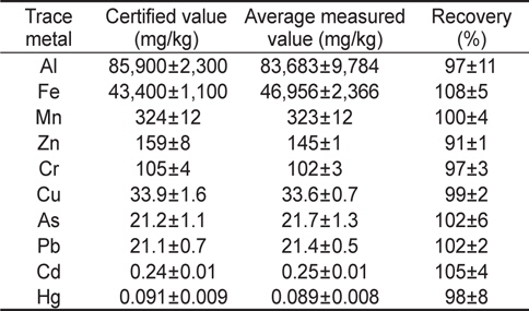
Certified value, average measured value and recovery of each trace metal for the reference material (MESS-3)
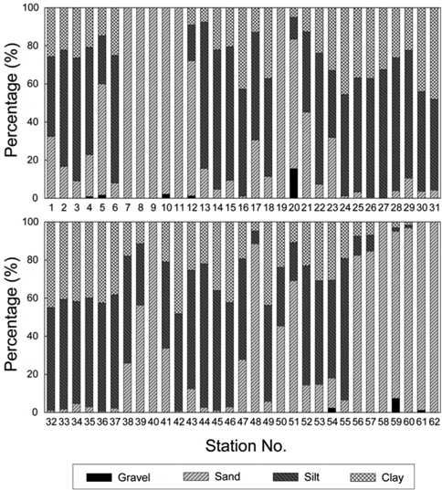
연구해역내 표층 퇴적물의 입도분석 결과를 바탕으로 각 정점별 자갈, 모래, 실트, 점토 조성을 Fig. 2에 나타내었다. 퇴적물중 자갈은 0.0-15.6%(평균 0.5±2.2%), 모래는 0.0-100%(평균 36.3±38.3%), 실트는 0.0-76.8%(평균 41.3±26.0%), 점토는 0.0-48.2%(평균 21.8±15.6%) 범위였다. 자갈은 평일도 남쪽에 위치한 정점 20과 청산도 서쪽에 위치한 정점 59에서 각각 15.6%와 7.5%로 다소 높은 함량을 보였고 대부분의 정점에서 미약하거나 나타나지 않았다. 모래는 득량만 입구쪽 거금도 주변의 정점 5와 정점 7-12, 평일도 남쪽의 정점 19와 20, 신진도 남쪽의 정점 39와 40, 노화도 주변의 정점 48과 51, 소안도 서쪽의 정점 56 과 57, 청산도 주변의 정점 58-62에서 50% 이상의 높은 함량을 보였으며, 그외 대부분의 정점에서는 전반적으로 세립질인 실트와 점토의 함량이 높았다.
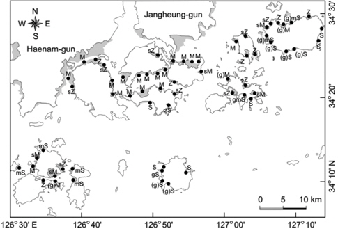
퇴적물중 자갈, 모래, 실트, 점토 함량을 기초로 Folk (1968)의 삼각좌표에 표시하여 각 정점별 퇴적물 유형(sedimentary type)을 살펴본 결과, 연구해역내 퇴적물은 실트(silt, Z), 사질실트(sandy silt, sZ), 니(mud, M), 약역질니[slightly gravelly mud, (g)M], 사질니(sandy mud, sM), 사(sand, S), 실트질사 (silty sand, zS), 니질사(muddy sand, mS), 역질사(gravelly sand, gS), 약역질사[slightly gravelly sand, (g)S], 역니질사(gravelly muddy sand, gmS), 약역니질사[slightly gravelly muddy sand, (g)mS)의 총 12개 퇴적물로 분류되었다(Fig. 3). 니(M) 퇴적물이 전체 퇴적물의 약 27% 로서 가장 우세하고, 주로 도암만 입구쪽의 고금도와 신진도 사이, 그리고 조약도 북쪽 주변에 분포하였다. 그외 세립질 퇴적물인 실트(Z)와 사질실트(sZ)가 약 10-15% 내외로 금당도 주변과 거금도 완도 북쪽에 분포하였으며, 조립질 퇴적물인 사(S)와 약역질사[(g)S)는 거금도 남쪽과 청산도 주변에 우세하게 분포하였다. 이러한 퇴적물 분포는 청산도와 각 섬의 남쪽지역의 경우 외해와 인접해 있어 외해로부터 조류 및 파랑 등 수리역학적 에너지의 직접적인 영향을 받기 때문인 것으로 생각된다. 한편, 퇴적물의 평균입도(mean grain size, Mz)는 2.0∼8.3Ø(평균 5.6±2.1Ø)범위로 중립사(medium sand)부터 극세립실트(very fine silt)사이로 다양한 입도를 보였다.
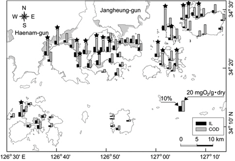
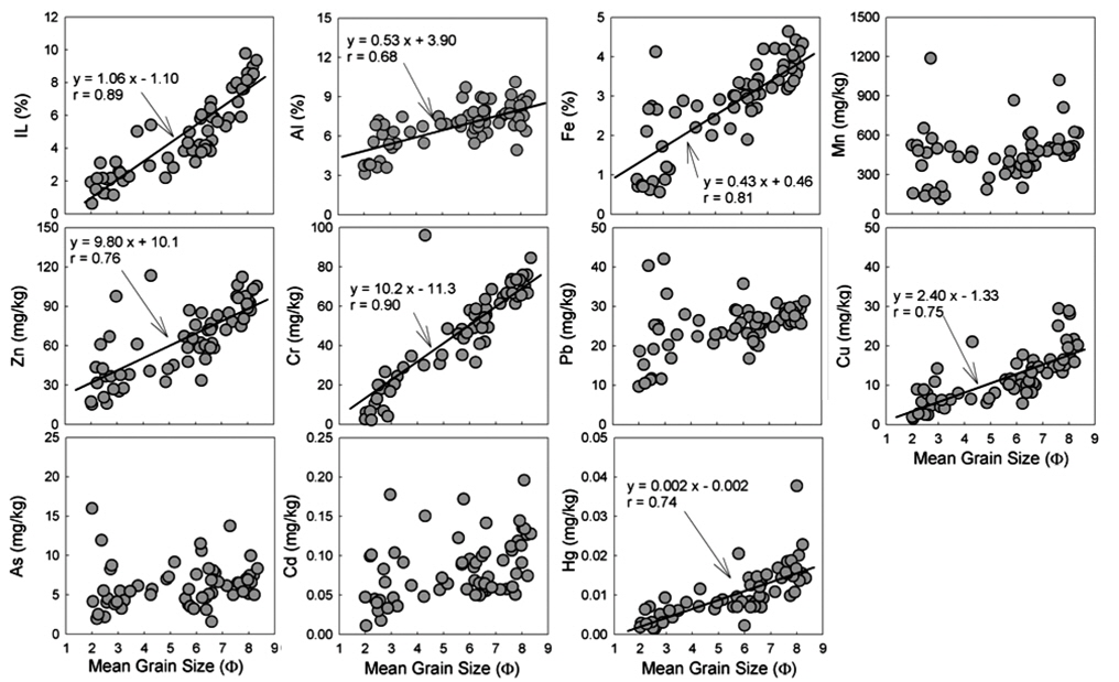
연구해역내 퇴적물중 유기물 함량특성을 알아보기 위하여 유기물 함량 특성을 나타내는 IL, COD, AVS농도를 살펴보았다. 퇴적물 중 IL과 COD는 각각 0.6-9.8%(평균 4.8±2.5%)와 1.0-41.0 mgO2/g∙dry(평균 15.3±7.9 mgO2/g∙dry) 범위였다. 전반적으로 육지쪽에 인접한 세립질의 니와 실트 퇴적물이 분포하던 득량만 입구쪽의 거금도 북서쪽과 금당도 주변, 도암만 입구 쪽의 고금도와 신지도 사이, 완도 북서쪽 정점들에서 상대적으로 높은 농도를 보였으며, 외해와 인접한 조립질인 사 퇴적물이 분포하던 청산도, 소안도, 신지도, 거금도 남동쪽 정점들에서 낮은 농도를 보였다(Fig. 4). 퇴적물 중 AVS 농도는 불검출-0.58 mgS/g∙dry(평균 0.08±0.13 mgS/g∙dry) 범위로 앞서 IL, COD와 유사하게 세립질 니 퇴적물로 이루어진 고금도와 신지도 사이 대부분의 정점들에서 약 0.15 mgS/g∙dry 이상의 높은 농도를 보였다. 그러나, 조립질인 사 퇴적물이 우세한 정점들에서는 검출되지 않거나 검출되어도 대부분 0.03 mgS/g∙dry 이하의 낮은 농도였다. 이와 같은 IL, COD, AVS의 공간적 분포를 보았을 때, 연구해역내 퇴적물중 유기물 함량은 입도와 밀접한 관련이 있는 것으로 생각되며, 퇴적물중 IL과 Mz 사이에 좋은 양의 상관성(r=0.89)을 보인 다는 사실이 이를 뒷받침해주고 있다(Fig. 5). 이와 같은 IL과 Mz 사이의 상관성에 관한 연구결과는 이전에 서해중부 및 전남 서부연안 갯벌 퇴적물에서도 보고된바 있다(Kim et al., 2008; Hwang et al., 2010; Choi et al., 2010; Hwang and Kim, 2011).
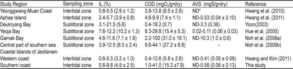
퇴적물중 COD와 AVS는 일반적으로 유기물 오염 및 퇴적물의 건강도 평가하는 기준으로 이용하고 있으며(Hyun et al., 2003), 일본에서는 수산생물 보호를 위하여 생물에 영향을 주는 기준농도를 COD는 20 mgO2/g∙dry, AVS는 0.2 mgS/g∙dry로 설정해 놓고 있다(Yokoyama, 2000). 이 기준을 적용하여 연구해역내 퇴적물의 유기물 오염현황을 살펴본 결과, COD는 전체 연구정점의 30%인 18개 정점에서, AVS는 전체 연구정점의 약 13%인 8개 정점(정점 1, 16, 32, 33, 36, 42, 49, 54)에서 일본의 퇴적물 오염기준을 초과하는 것으로 나타났다(Fig. 4). 또한, 이 연구결과를 연구해역과 인접한 해역에서 조사된 퇴적물중 IL, COD, AVS 농도와 비교하였을 때, 연구해역의 퇴적물은 양식활동이 활발한 반폐쇄적인 내만인 여자만(Hue et al., 2000)과 가막만(Noh et al., 2006a) 및 연구해역과 인접한 남해 중부해역(Noh et al., 2006b)의 조하대 퇴적물에 비해서는 낮았으나 연구해역 북서쪽의 영광-무안 연안(Hwang et al., 2010)과 압해도(Hwang et al., 2011), 전남 서부도서(Hwang and Kim, 2011) 해역의 갯벌 퇴적물 보다는 다소 높은 농도였다(Table 2). 이러한 연구해역내 퇴적물중 유기물 함량이 연구해역 인근의 다른 갯벌 퇴적물에 비해 높은 것은 완도를 포함한 전라남도 남부연안의 경우 조간대 하부를 중심으로 전복, 미역, 김, 굴 등을 생산하는 수많은 해조류 및 패류 양식장이 산재해 있다는 사실을 고려할 때(Ock, 2010; Yang et al., 2012), 주변 양식생물의 잔해나 배설물 등과 같은 양식 부산물의 영향 때문인 것으로 생각된다. 최근, Yoon (2000)은 거금도와 고흥반도 사이의 표층 퇴적물의 유기물 유입원으로서 연안에서 이루어지고 있 는 해조류 양식 잔해물을 언급한 바 있다. 하지만, 연구해역내 완도와 고금도, 거금도 및 금당도 주변 해역은 도암만과 득량만으로 흘러들어오는 탐진강과 소규모 하천을 통해 유입되는 담수의 영향을 받는 해역이고(Lee and Park, 2006), 육상의 해안가를 따라 양식생물을 가공하는 시설로부터 배출수가 해양으로 정화되지 않은 채 바다로 흘러 들어오기 때문에, 연구해역으로 유입되는 담수와 인근 육상에 위치한 수산가공시설의 배출수를 통해 유입되는 육상기원 유기물의 영향 또한 배제할 수 없다. 따라서, 연구해역내 퇴적물중 유기물 공급원을 알아내기 위한 퇴적물내 탄소와 질소 동위원소(13C와 15N) 및 생화학적 성분(carbohydrates, lipids, proteins) 분석 등과 같은 추가적인 연구가 필요하다.
The content of ignition loss (IL) and the concentrations of chemical oxygen demand (COD) and acid volatile sulfide (AVS) in coastal surface sediments (0-2 cm) from the Jeollanam Province. The parenthesis represents the average and standard deviation of each parameter in surface sediment
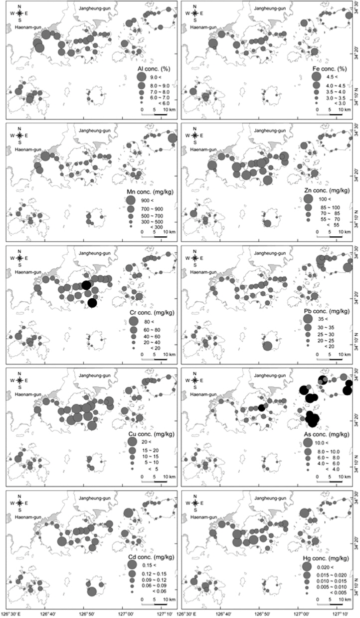
연구해역내 갯벌 퇴적물 중 미량금속을 분석한 결과, 알루미늄(Al)은 3.1-10.2%(평균 6.9±1.6%), 철(Fe)은 0.5-4.7%(평균 2.8±1.1%), 망간(Mn)은 114-1,188 mg/kg(평균 456±194 mg/kg), 아연(Zn)은 15-114 mg/kg(평균 65±27 mg/kg), 크롬(Cr)은 2.1-96.0 mg/kg(평균 45.7±23.7 mg/kg), 납(Pb)은 9.6-42.1 mg/kg(평균 24.7±6.3 mg/kg), 구리(Cu)는 1.5-29.5 mg/kg(평균 12.0±6.7 mg/kg), 비소(As)는 1.6-16.0 mg/kg(평균 6.2±2.7 mg/kg), 카드뮴(Cd)은 0.011-0.196 mg/kg(평균 0.083±0.039 mg/kg), 수은(Hg)은 0.001-0.038 mg/kg(평균 0.010±0.006 mg/kg) 범위였으며, 대부분의 미량금속들이 정점에 따라 10배 이상의 큰 농도차이를 보였다.
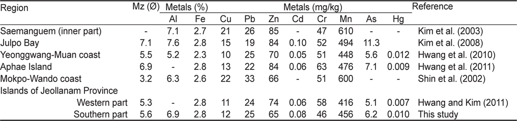
일반적으로 퇴적물중 미량금속의 농도는 주로 퇴적물의 입도와 유기물 함량의 영향을 받는 것으로 알려져 있으며, 이는 한반도 연안 퇴적물에서 흔히 나타나는 특징이다(Cho and Park, 1998; Choi et al., 1999; Cho et al., 2001; Shin et al., 2002; Hwang et al., 2010). 연구해역 또한 지각내 풍부한 Al과 Fe, 친철원소인Cr, 그리고 생물 필수원소(essential metal)인 Zn과 Cu, 그리고 Hg이 앞서 유기물 분포와 유사하게 세립질인 니와실트 퇴적물로 이루어진 득량만 입구의 거금도 북서쪽과 도암만 입구의 고금도와 신지도 사이, 그리고 완도 북서쪽의 정점들에서 높은 농도를 보였으며 외해의 영향을 직접적으로 받는 사퇴적물로 이루어진 거금도 남쪽과 청산도, 소안도 주변 정점들에서 낮은 농도를 나타내었다(Fig. 6). 특히, Al, Fe, Cr, Zn, Cu, Hg은 입도와 좋은 양의 상관성(r=0.68-0.90)을 보여(Fig. 5), 퇴적물중 이들 원소들의 농도가 입도와 밀접한 관련이 있는 것으로 생각된다. 반면, Mn은 완도 북서쪽, Pb은 득량만 입구쪽의 거금도 주변, As는 득량만 입구쪽의 거금도와 금당도, 평일도 주변, Cd은 도암만 입구쪽의 고금도와 신지도 사이 정점들에서 높은 농도를 보였으며, 뚜렷한 공간적인 분포경향과 입도와의 상관성을 보이지 않았다. 따라서, 이들 미량금속들은 입도 외에 다른 이차적인 요인 즉, 외부기원 오염물질의 유입 혹은 퇴적물내 산화·환원 환경(redox condition)하에서의 속성작용(diagenesis)의 영향을 받고 있는 것으로 생각된다. 이와 같이 Al, Fe, Cr, Zn, Cu, Hg은 퇴적물의 입도와 좋은 양의 상관성을 보이는 반면 Mn, Pb, As, Cd은 입도와 뚜렷한 상관성을 보이지 않는다는 연구결과는 이전에 전라남도 영광-무안 연안의 갯벌퇴적물(Hwang et al., 2010)에서도 보고된 바 있다. 한편, 연구 해역내 퇴적물중 미량금속 농도는 이전에 서해중부의 새만금(Kim et al., 2003)과 줄포만(Kim et al., 2008), 전남 서부의 압해도(Hwang et al., 2011) 갯벌 퇴적물에서 보고된 미량금속 농도에 비해 Fe, Pb, Hg은 비슷한 반면 그외 미량금속들은 상대적으로 낮았다(Table 3). 그러나, 비슷한 입도를 가진 전남 북서부의 영광-무안 연안(Hwang et al., 2010)과 전남 서부도서(Hwang and Kim, 2011) 갯벌 퇴적물에서 보고된 미량금속 농도에 비해 Fe, Pb, Zn, Cr 은 비슷하거나 낮았지만 그 외 미량금속들은 상대적으로 높았다.

The mean grain size (Mz) and the average concentration of trace metals in intertidal sediments from the western and southern coasts of Korea
퇴적물내 높은 미량금속 농도는 퇴적물로부터 영양분을 얻거나 퇴적물을 기반으로 서식하는 저서생물 및 유용수산생 물의 체내에 축적되어 악영향을 주고(Woo et al., 1999, 2003), 생태계 먹이사슬을 통하여 전이되면서 인간의 건강을 위협을 줄 수 있기 때문에 연안해역에서 퇴적물내 미량금속의 오염평가는 매우 중요하다. 특히, 연구해역과 같이 굴, 미역, 전복, 김 등의 패류 및 해조류 양식이 활발하고 갯벌로부터 바지락, 새꼬막 등의 수산생물을 채취하는 해역에서는 이러한 퇴적물내 미량금속의 오염 현황을 파악할 필요가 있다. 따라서, 이 연구에서는 최근 국내외 연구자들(Loska et al., 1997; Chen et al., 2007; Hyun et al., 2007; Lee et al., 2008; Hwang et al., 2010, 2011; Feng et al., 2011; Hwang and Kim, 2011)이 사용한 오염기준(sediment quality guidelines; SQGs), 농축계수(enrichment factor, EF) 및 농집지수(geoaccumulation index, Igeo)를 이용하여 연구해역내 갯벌 퇴적물중 미량금속의 오염도를 살펴보았다.
미량금속의 오염기준(SQGs)을 이용한 평가는 연구해역내 퇴적물중 미량금속 농도와 미국 해양대기청(National Oceanic and Atmospheric Administration, NOAA)에서 권고하고 있는 ERL (effect range low) 및 최근 해양수산부에서 개정한 해양환경기준중 퇴적물에 대한 미량금속 오염기준중 주의기준 (threshold effects level, TEL)을 비교하여 알아보았다. 먼저, 미국 NOAA에서 권고하는 각 원소별 ERL값은 Cu 34 mg/kg, Pb 46.7 mg/kg, Zn 150 mg/kg, Cd 1.2 mg/kg, Cr 81 mg/kg, As 8.2 mg/kg, Ni 20.9 mg/kg, Hg 0.15 mg/kg, Ag 1.0 mg/kg이다 (Buchman, 2008). 이들 ERL값을 기준으로 초과하는 미량금속 농도를 함유한 퇴적물은 서식생물에 영향을 줄 가능성이 있음을 의미한다. 연구해역내 퇴적물중 미량금속 농도를 이들 기준과 비교해 보았을 때, Mn, Zn, Pb, Cu, Cd, Hg 은 모든 정점에서 ERL보다 낮았으나, Cr은 고금도와 신지도 남쪽 정점 31(84.5 mg/kg)과 39(96.0 mg/kg )에서, As는 득량만 입구쪽 고금도 주변의 정점 2(10.6 mg/kg), 7(8.3 mg/kg), 8(11.9 mg/kg), 금당도 주변의 정점 14(8.4 mg/kg ), 15(11.5 mg/kg ), 16(10.0 mg/kg), 평일도 주변의 정점 17(9.1 mg/kg ), 18(13.7 mg/kg ), 19(16.0 mg/kg), 20(8.8 mg/kg)에서 ERL을 초과하는 것으로 나타났다(Fig. 6).
2013년 해양수산부에서 개정한 해양환경기준의 퇴적물 오염 기준중 TEL을 연구해역내 퇴적물중 미량금속 농도와 비교하였다. 각 원소별 TEL 값은 Cu 20.6 mg/kg, Pb 44.0 mg/kg, Zn 68.4 mg/kg, Cd 0.75 mg/kg, As 14.5 mg/kg, Hg 0.11 mg/kg 이며(http://www.mof.go.kr), TEL 값을 초과하는 퇴적물은 금속에 의한 부정적인 생태영향이 발현될 가능성이 높음을 의미한다. 여기서, TEL 농도를 이용한 오염평가시 미량금속중 Pb, As, Cd, Hg은 퇴적물중 미량금속 농도와 기준농도 사이에 직접적인 비교가 가능하지만 Cu와 Zn은 퇴적물중 Li 혹은 Cs을 이용하여 입도의 영향을 고려한 보정농도를 산출하여 비교하여야 한다. 하지만, 이 연구의 경우 우리나라의 퇴적물 기준을 설정하기 이전에 연구가 이루어져 Li과 Cs의 분석결과가 없기 때문에 Cu와 Zn의 오염평가가 불가능하다. 따라서, 이 연구에서는 이들 미량금속을 제외한 Pb, As, Cd, Hg에 대해서만 오염평가를 실시하였다. 그 결과, 연구해역내 퇴적물중 Pb, Cd, Hg 은 모든 정점에서 TEL 값보다 낮았으나 As의 경우 평일도 주변의 정점 19 (16.0 mg/kg )에서 TEL 값을 초과하는 것으로 나타났다.
EF와 Igeo를 이용한 퇴적물의 오염평가는 다음의 방정식 1과 2로부터 각각 그 값을 계산한 후 알아보았다.
여기서, (Me/Al)observed는 연구해역내 퇴적물중 Al에 대한 각 미량금속의 농도비를, (Me/Al)crust는 지각물질중 Al에 대한 각 미량금속의 농도비, Cn은 연구해역내 퇴적물중 미량금속의 농도, Bn은 미량금속의 배경농도(background or reference concentration)를 나타낸다. 일반적으로 지각물질중 미량금속의 농도와 미량금속의 배경농도는 연구해역 주변에 오염되지 않은 해역의 퇴적물중 미량금속 농도 혹은 세일이나 전세계 지각물질중 미량금속의 평균농도를 사용한다(Hyun et al., 2003; Hwang et al., 2010; Feng et al., 2011). 이 연구에서는 연구해역 바깥쪽의 오염되지 않은 해역의 퇴적물 결과값이 없고, 최근 Lim et al. (2007)이 한반도 주변의 연안 퇴적물중 미량금속 분석결과를 바탕으로 입도보정을 통한 배경농도 산정을 위한 계산식을 제공하였으나 이는 일부 미량금속(Cu, Zn, Cr, Ni)에 대하여 제한적이다. 또한, Yoon et al. (2009)이 한반도 주변 기반암중 미량금속의 농도를 분석하여 연구해역 주변에 분포하는 변성암, 쥬라기 화강암, 백악기 화강암과 같은 기반암중 Cu (11.4-18.8 mg/kg), Pb (17.7-24.9 mg/kg), Zn (55.0-68.4 mg/kg), Cr (15.3-42.5 mg/kg), As (6.2-7.9 mg/kg), Ni (9.4-24.0 mg/kg)의 자연적인 배경농도를 제시하였으나 EF 계산을 위한 Al과 Fe 농도가 빠져있어 오염평가가 불가능하다. 따라서, 이 연구에서는 우리나라를 포함한 동북아시아 주변의 퇴적물 오염평가시 최근까지 국내외의 많은 연구자들(Chen et al., 2007; Kim et al., 2008; Zhang et al., 2009; Hwang and Kim, 2011; Zhu et al, 2011; Jeon et al., 2012b)에 의해 이용되고 있는 Taylor (1964)와 Taylor and McLennan (1995)이 보고한 전세계 연안 대륙붕해역 퇴적물중 미량금속의 평균농도(Al 8.0%, Fe 3.5%, Mn 600 mg/kg, Zn 71 mg/kg, Cr 35 mg/kg, Pb 20 mg/kg, Cu 25 mg/kg, As 1.5 mg/kg, Cd 0.098 mg/kg, Hg 0.08 mg/kg)를 배 경농도로 사용하여 연구해역내 퇴적물의 오염도를 평가하였다.
연구해역내 퇴적물의 미량금속 농도를 이용하여 계산한 EF결과를 Table 4에 나타내었다. EF는 지각물질중 보존적 성질을 가진 Al 혹은 Fe을 표준화 원소로 사용하여 지각중의 각 원소 사이의 농도비와 연구해역내 미량금속의 농도비를 이용하여 미량금속의 농축 정도를 평가하는 방법으로, 일반적으로 EF =0.5-1.5인 경우 오염되지 않은 자연적인 농도, EF > 1.5 인 경우 대기 혹은 하천을 통하여 미량금속의 유입으로 오염된 것으로 평가한다(Zhang and Liu, 2002; Hyun et al., 2007; Hwang and Kim, 2011). 하지만, 최근 Birth (2003)와 Chen et al. (2007)은 이들 EF 값을 7 단계로 좀더 세분화하여 퇴적물내 미량금속 오염을 평가하였으며 이 연구에서도 이 세분화된 기준을 적용하여 미량금속의 오염도를 자세히 살펴보았다. 그 결과, Hg은 모든 정점에서, Cu는 고금도와 신지도 주변(정점 24, 30, 35-37, 39), Mn은 주로 평일도(정점 19, 20, 24), 청산도(정점 59-62) 주변과 완도 북서쪽(정점 44-47), Cd은 주로 거금도(정점 1, 4, 7), 금당도(정점 15, 16), 평일도(정점 18, 19, 22-24), 청산도(정점 59, 61, 62) 주변과 고금도와 신지도 사이(정점 30-39)의 일부 정점을 제외한 모든 정점에서 EF값이 1 보다 낮아 전반적으로 오염이 되지 않은 상태(no enrichment)인 것으로 나타났다. 하지만, Zn, Pb, Cr은 연구해역내 거의 모든 정점에서 EF값이 1.0-3.0 사이였으며 각각 평균값이1.06, 1.48, 1.45로 약간 오염된 상태(minor enrichment)에 해당하였다. 특히, As는 거의 모든 정점에서 EF 값이 3.0-10.0 사이였으며 평균 5.0 으로서 적당한 오염상태(moderate enrichment)와 적당히 심한 오염상태 (moderately severe enrichment)의 중간 정도에 해당하였다. 특이하게 득량만 입구쪽의 거금도, 금당도, 평일도 주변 정점들에서 EF 값이 3.0-22.8(평균 7.3)범위로 대부분 5.0 이상을 나타내어 연구해역내 다른 정점들에 비해 상대적으로 높았다.
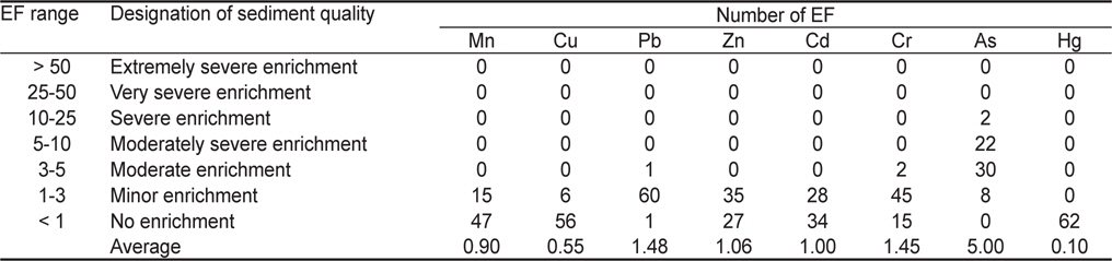
Classification of enrichment factor suggested by Chen et al. (2007) and the number of EF for the ratios of trace metals relative to Al in intertidal sediments of coastal islands from the southern region of Jeollanam Province and in earth crust reported by Taylor (1964) and Taylor and McLennan(1995)
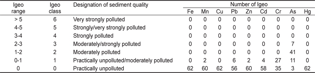
연구해역내 퇴적물의 미량금속 농도를 이용하여 계산한 Igeo 결과를 Table 5에 나타내었다. Igeo는 퇴적물에 함유된 미량금속의 농도를 오염되지 않은 미량금속의 농도로서 정량화하여 평가하는 방법으로, 총 7단계로 나누어 오염도를 평가한다(Jeon and Cho, 2002; Lee et al., 2008; Hwang and Kim, 2011). 각 정점별 Igeo 결과값을 기초로 연구해역내 퇴적물중 미량금속 오염도를 살펴보면, Fe, Cu, Hg은 모든 정점에서, Mn은 거금도(정점 7)과 완도(정점 45), Pb은 거금도(정점 1, 7, 12), 평일도(정점 18), 고금도(정점 31), 청산도(정점 61) 주변, Zn은 신지도(정점 39)와 완도(정점 46) 주변, Cd은 금당도(정점 16), 신지도(정점 39), 완도(정점 41), 청산도(정점 61) 주변의 일부 정점들을 제외하면 Igeo class가 0를 보여 오염되지 않은 수준(practically unpolluted)에 해당하였다. Cr또한 비록 조약도 주변의 모든 정점과 고금도와 신지도 사이의 거의 모든 정점들에서 Igeo class가 1로써 오염되지 않은 수준과 약간 오염된 수준(moderately polluted)의 중간단계에 해당하였으나 그외 정점에서는 Igeo class 가 0을 보여 전반적으로 오염되지 않은 수준(practically unpolluted)에 해당하였다. 하지만, As 는 연구해역내 대부분의 정점에서 Igeo class가 2였으며, 특히, 거금도(정점 2, 8)와 금당도(정점 15, 16), 평일도(17-19)의 일부 정점에서 Igeo class가 3을 나타내었다. 따라서, 연구해역내 As는 전반적으로 약간 오염된 수준에 해당하였다.

Classification of geoaccumulation index and the number of Igeo class for the concentrations of trace metals in intertidal sediments of coastal islands from the southern region of Jeollanam Province
이상의 평가기법들을 이용한 퇴적물 오염 평가결과를 종합해보면, 연구해역내 갯벌 퇴적물은 미량금속에 대하여 Fe, Mn, Cu, Pb, Zn, Cd, Hg, Cr은 오염되지 않은 것으로 나타났으나 As는 비록 저서생물에 영향을 줄 만큼 우려할 만한 농도는 아니지만 다른 미량금속에 비해 상대적으로 오염된 것으로 나타났다. 이와 같은 결과는 이전에 전남 서부 연안의 갯벌 퇴적물내 미량금속 오염도 평가결과(Hwang et al., 2010; Hwang and Kim, 2011; Hwang et al., 2011)와 유사하다. 이러한 연구해역을 포함한 전남 서부연안 갯벌 퇴적물내 높은 As농도에 대하여 아직 명확하게 밝혀진 연구결과는 없다. 일반적으로 As는 농약, 살충제, 제초제 등의 원료로 사용되기 때문에 연구해역 주변의 농사를 짓는 과정에서 토양에 살포된 후 강우시 지하로 스며들어 지하수중의 As 농도를 높일 가능성이 있다(Hwang et al., 2011). 또한, 앞서 설명하였듯이 연구해역을 포함한 전남 남서부 지역에는 변성암, 쥬라기 및 백악기 화강암이 분포하고 있고(Shin et al., 2002), 지질학적인 특성에 의해 이들 화강암 중에는 As 함량이 다른 광물에 비해 높은 것으로 알려져 있다(Yoon et al., 2009). 광물 중 높은 As 함량을 가진 지역에서는 지표수 유입에 의한 산화과정에서 광물로부터 As가 용출되어 지하수중 As 농도가 높다(An et al., 2007). 특히, Kim et al. (2005)과 Kim et al. (2010)에 의하면 연구해역 인근의 영산강을 포함한 한반도 연안에서 해안가를 통해 많은 양의 지하수가 바다로 유입된다고 보고하였다. 이러한 결과를 바탕으로 최근 Hwang and Kim (2011)과 Hwang et al. (2011)은 한반도 남서해안의 갯벌 퇴적물내 높은 As 농도에 대하여 주변 육상의 지질학적 특성과 농업활동으로 인해 As가 오염된 지하수 유입의 영향일지 모른다고 보고하였다. 그러나, 연구해역을 포함한 우리나라의 전남 남서부해역은 우리나라의 대표적인 해조류 양식해역으로서 양식 생산량이 전국의 80% 이상을 차지하고, 특히 육상에는 이들 해조류 가공시설이 산재해 있다(http://kosis.kr). 이들 해조류는 해수로부터 As를 효율적으로 농축하는 능력을 가지고 있어 다른 수산생물에 비해 높은 As 농도를 보인다(Norman et al., 1987; Vasconcelos and Lean, 2001; Rose et al., 2007). 최근, Na (2004)는 연구해역 인근의 목포연안 해조류의 체내 미량금속 농도와 조간대 퇴적물중 일부 미량금속 농도가 좋은 양의 상관성을 보인다고 보고하였다. 따라서, 앞서 유기물 분포에서 언급하였듯이 연구해역 주변의 해조류 양식장 혹은 육상의 가공시설로부터 해조류 부산물이 조간대 퇴적물에 집적될 경우 퇴적물내 높은 As 농도를 나타낼 가능성 또한 배제할 수 없다. 그러므로, 이와 같이 퇴적물중 As 오염을 일으킬 수 있는 여러 가지 요인들을 고려하여 앞으로 한반도 서남해안 갯벌 퇴적물중 높은 As 농도에 대한 원인을 밝히기 위한 추가적인 연구가 필요하다.