Water availability is dependent on climate, geologic, hydrologic, and hydrogeological factors. The adverse conditions prevailing in the Aguata-Awka area, with a land size of about 525 km2, has necessitated the development of local technology to cope with the water scarcity in the area. Favorable climatic conditions bring rain in the months of April to October, which is stored by the people for later use.
Rainwater harvesting in the tropical regions of the world is practiced for domestic, commercial, and agricultural uses [1,2]. Household rainfall catchment systems are very appropriate in areas with average rainfall greater than 200 mm per year and no other accessible water source [3]. Rainwater is ubiquitous and free of charge, and is gaining interest as a good water supply option to solve water supply problems and increasing water charges. It serves as one of the most appropriate alternatives to treated water [4]. Rainwater is one of the purest sources of water. Rainwater harvesting systems may be installed and serviced in remote villages, and may be constructed with local materials and local human power for low cost and efficient maintenance [5].
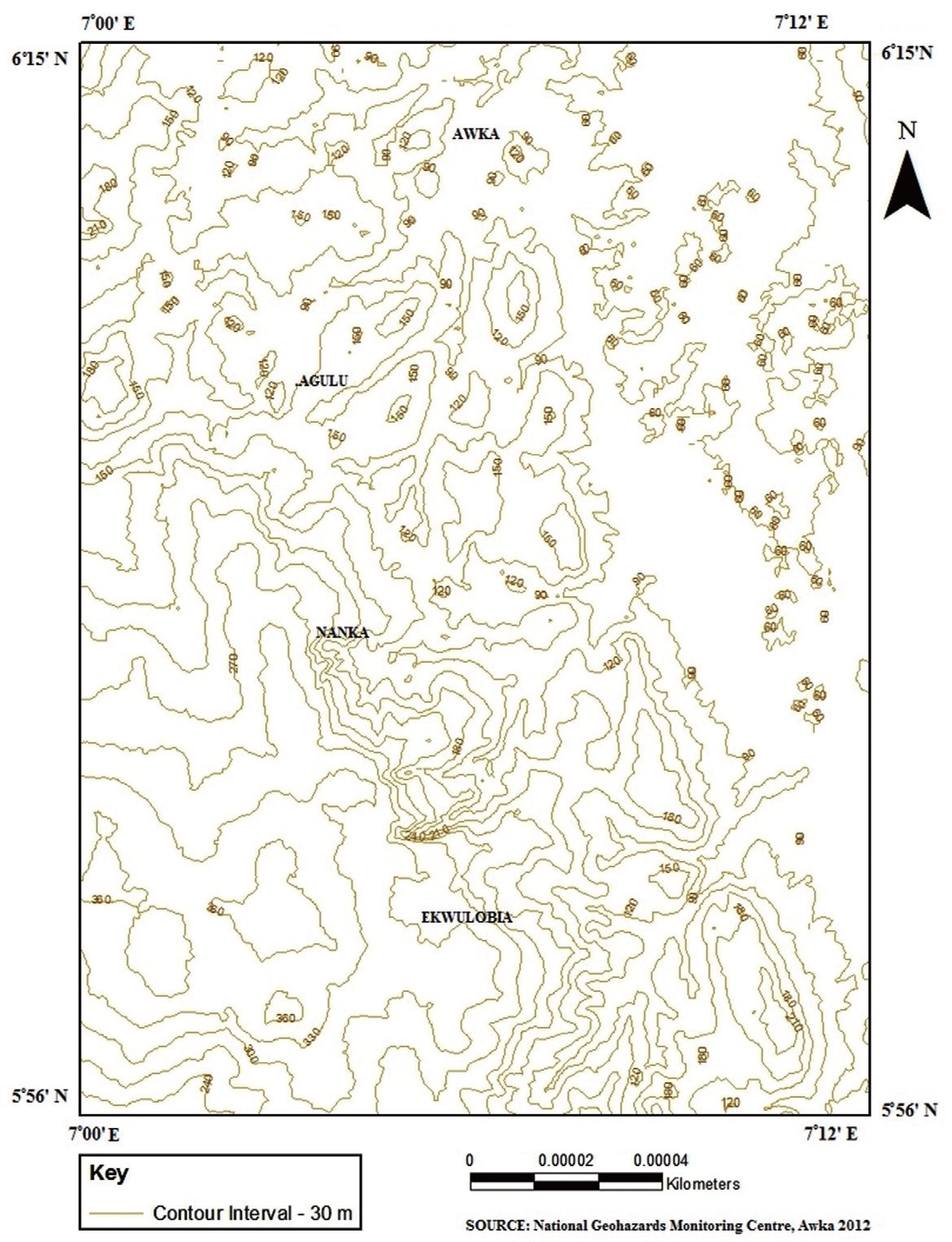
The study focuses on the Aguata-Awka area in southeastern Nigeria (Fig. 1). It is bounded by latitudes 5°56′ and 6°15′N and longitudes 7°00′ and 7°12′E (Fig. 2). The simple local technology adopted by the people involves collection of water from roof channels, and channeling it to surface or underground reservoirs. This alternative source of water supply is meeting the water requirements of the semi-urban and rural communities whose population range from 5,000?30,000.
The Aguata-Awka area consists of hills, valleys, and plains. The maximum elevation is 335 m above sea level in the south and slopes to 61 m to the northeast. The climate of the area is tropical and experiences two climate seasons: the rainy season and the dry season. The rainy months begin in April and last until October, while the dry season, which is characterized by little or no rainfall prevails from November to March. The amount of
rainfall for the years 1993 to 2010 ranged from 1,525.4 to 2,505.1 mm. Average annual precipitation for the period is 1,937.9 mm. Average maximum monthly temperature for the rainy season is 29.5℃ while the minimum temperature is 23.6℃. In the dry season, the average maximum temperature is 34.5℃ while the minimum temperature is 23.8℃. Average evaporation rate values for the rainy and dry seasons are 2.2 and 4.4 mm, respectively (Table 1).
The study area lies within the Anambra basin and is underlain by the Ameki formation, its lateral equivalent the Nanka sands (Eocene), the Imo shale (Paleocene) and its lateral equivalent the Ebenebe sandstone [6,7].
The objective of this study was to investigate the use of alternative local technology methods adopted by the people for overcoming water problems in their localities.
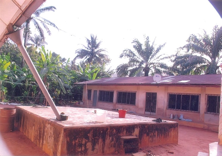
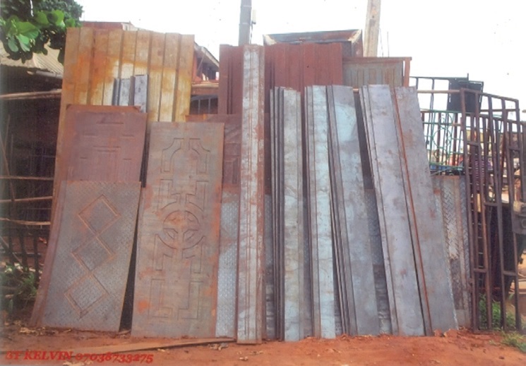
The study is mainly field oriented. Visits were made to communities to ascertain their mode of water supply in the dry season. Mode of construction, and materials were sourced (Fig. 3) locally. Pictures were taken and used to capture the situation on ground. Harvesting rainwater ameliorated the suffering of the people.
Meteorological data for the years 1993 to 2010 were obtained for rainfall, temperature, and evaporation from the records of the Nigerian Meteorological Agency outstation, Awka [8]. Installed equipments at the agency are the standard ordinary rain gauge, and self-recording rain gauge, for measuring amount of rainfall. Dry bulb and wet bulb thermometers, for measuring temperature, and the Piche Evaporimeter for measuring the rate
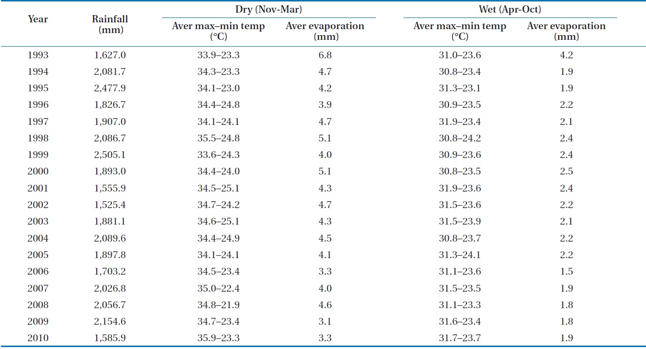
Amount of rainfall, average max and min temperature (November?March), average max and min temperature (April?October), and average evaporation rates (1993?2010 for Awka area)
of evaporation. Water samples during rainfall were collected and analyzed for their physical, chemical, and bacteriological parameters. Collection of water samples were made using plastic containers and kept under refrigeration prior to analysis. Analyses were carried out within 48 hr at the Water Quality Laboratory of Anambra State, Rural Water Supply and Sanitation Agency― the United Nations Children’s Fund assisted, Awka.
The pH was measured using a pH meter (Jenway3051; Jenway Ltd., London, UK). Temperature, total dissolved solids, and conductivity were measured using a conductivity meter (bridge type, MC; Kent-EIL5013; Kent Industrial Measurements Ltd., Chertsey, UK). The cations and anions: Ca2+, Mg2+, Fe2+, SO4 2-, Cl-, NO3-, PO4-P, and S1O2 were determined using a DREL spectrophotometer (HACH, Loveland, CO, USA); HCO3- and CO32- by the titration and calculation method, while total hardness was obtained by the titration method.
Fecal and total coliforms were determined using the Hatch Millipore bacteriological kit membrane (filtration method). All analytical methods and results obtained were within the operational standards of the Standards Organization of Nigeria (SON) [9], the World Health Organization (WHO) [10], and GEMS/Water operational guide [11].
Water samples were collected from aluminum, galvanized iron sheet and concrete roofs in Agulu, Awka, and Ekwulobia communities, respectively. Because of the dearth of water in the area, the situation has necessitated the indigenous people/local populations to resort to rainfall harvesting as an alternative source of water supply. Results indicate the pH values to be 5.9 for the galvanized iron sheet, 6.2 for aluminum, and 7.1 for concrete roof sources. Turbidity values obtained ranged from 0.9 to 2.7 mg/L, while total dissolved solids were determined to be 80 to 170 mg/L, and conductivity values are between 160 and 360 μS/cm.
Chemical analysis of calcium determined a range between 3.4 and 5.2 mg/L, and magnesium was determined to vary from 1.2 to 1.4 mg/L. The bicarbonate determined ranged from 19.4 to 83.6 mg/L while sulfate concentrations were determined to range between 3.6 and 6.4 mg/L. A value of 0.1 mg/L for iron was obtained for the galvanized iron roof. Total hardness ranged from 4.5 to 6.4 mg/L. No nitrate or phosphate ions were detected
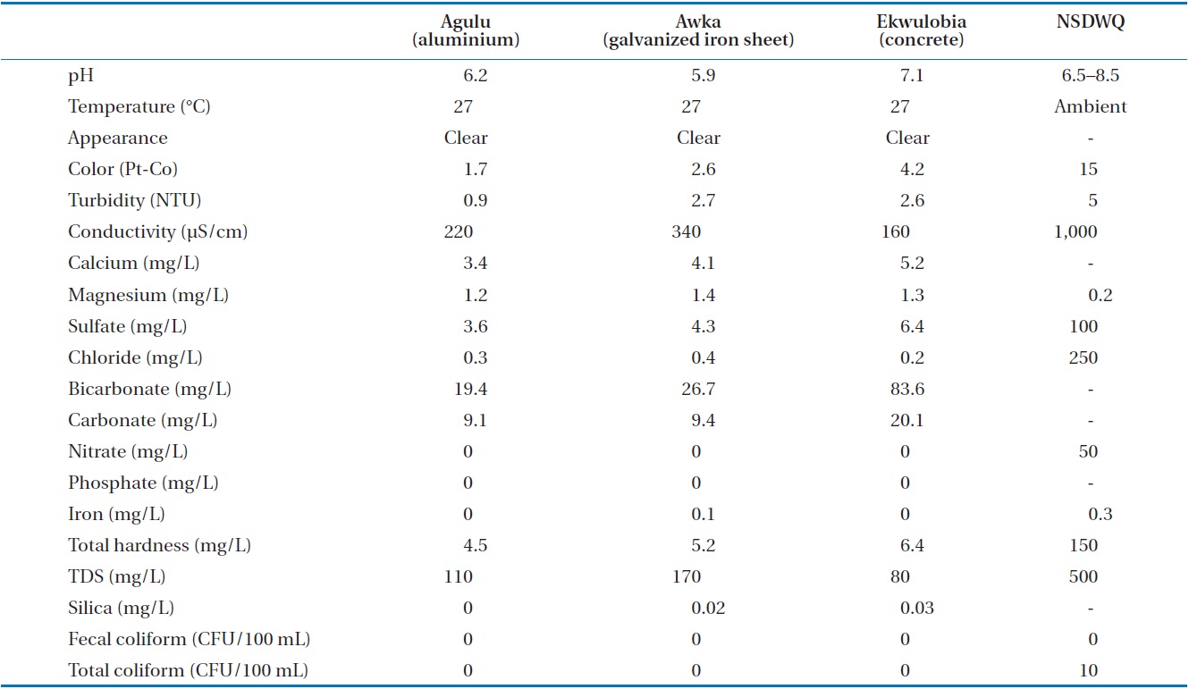
Water quality analysis of rainfall in 3 communities compared to the Standard Organization of Nigeria - Nigerian standards for drinking water quality (NSDWQ) 2007
from any of samples (Table 2).
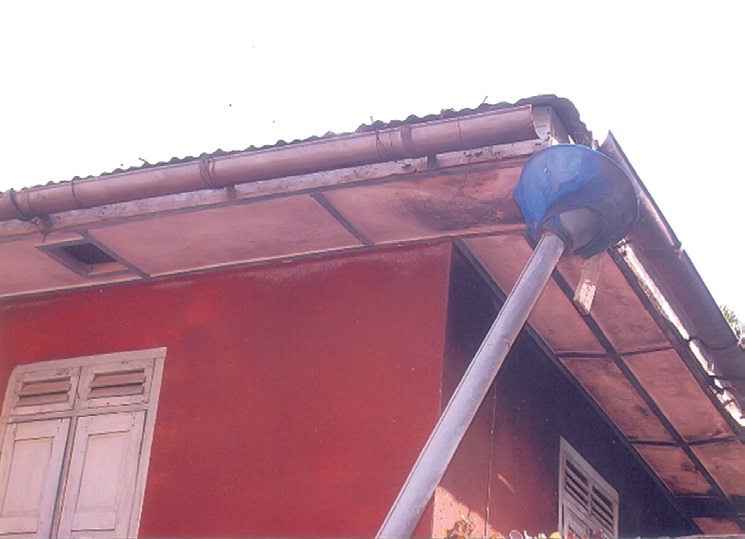
Bacteriological analysis results were negative for fecal and total coliforms counts. All parameters, with the exception of pH for the aluminum and galvanized iron roofs, conformed with the recommended guideline standards of the WHO [10,12] and the SON Nigerian standards for drinking water quality (NSDWQ) [9]. The magnesium ion analyzed however is above the maximum permitted level for consumer acceptability of the NSDWQ, 2007. The water is slightly acidic to neutral and can be classified as fresh and soft. The rainwater can be described as the calcium and bicarbonate type. The urban and rural populace has developed local technology which involves the use of U-shaped aluminum and galvanized iron materials. They are hung from the roof and fitted into a bucket like funnel for collecting rainwater
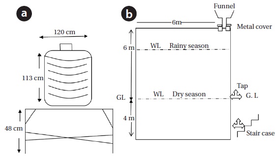
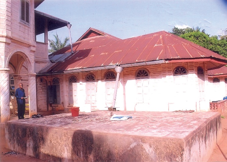
(Fig. 4). Water collected is channeled into large concrete underground tanks, shallow hand-dug wells and surface reserviors (Fig. 5). Concrete reservoirs of 6 m × 6 m × 4 m dimension are either built on pillar supports or built underground for greater storage capacity (Fig. 6).
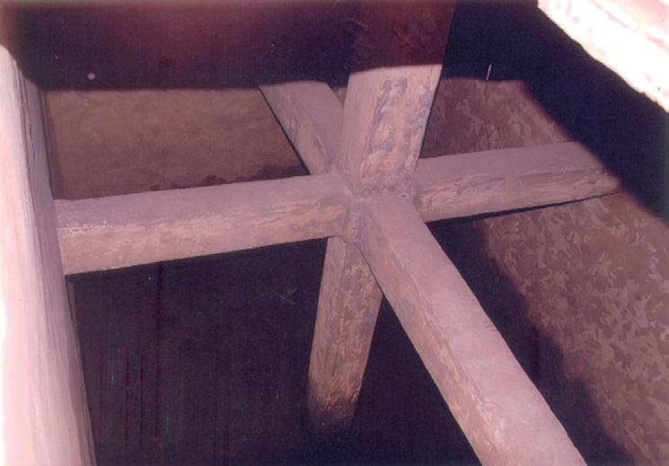
In the rainy season, the reservoirs are filled and water can be conveniently collected from the taps constructed at the surface. The concrete reservoirs of 6 m × 6 m × 4 m dimension have a storage capacity of 144 m of water, and smaller polyvinyl chloride (PVC) tanks of 4,500 and 9,000 L capacities are also used
for storing water as supplementary containers (Fig. 7). They are commonly used during the rainy season, especially in rural areas where pipe line network is lacking. These reservoirs are in all the households in Nanka, Ekwulobia, Amesi, Akpo, and Umuchu communities. Adequate structural designs are carried out to prevent collapse or leakage into the sandy aquifers housing the reservoirs (Fig. 8).
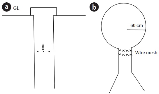
Deep hand-dug wells in the area serve dual purpose (Fig. 9). Water is stored in them from rainwater collected for domestic purposes and at the same time rills erosion within compounds is checked. Wire mesh is placed at the mouth of entry into the reservoirs, plastic tanks and hand-dug wells, to hold back particulate materials, droppings from birds, leaf straws and leaves falling on roofs during windy storms. The nets prevent dirt sediments being washed from roofs, and mosquitoes from breeding in the water tanks [13].
Awka, Agulu, Nanka, Oko, Isuofia, Amesi, Ukpo, and Umuchu are underlain by the Nanka sands. The geological formation in the area consists of uncemented loose, medium to coarse grained and pebbly quartz sand. Here the infiltration capacity of the soil is high and aquifers occur at great depths.
Occurrence of groundwater and surface water are dependent on geology and topography. Water levels are 100 to 300 m below ground surface in places [14], while the water table however becomes more shallow towards water courses.
The poor rural people cannot drill water boreholes for their domestic and agricultural purposes as the costs for drilling boreholes
are very prohibitive. River, streams, and springs are far from many homesteads, requiring the people to trek long distances of up to 1 to 2 km to fetch water. Springs as sources of potable water occur down deep valleys at the interface between sandstone ridges and underlying shade beds. The stress associated with search for water has impacts on the health of the people [15].
The scarcity of water experienced by the people, especially in the dry season, and the exorbitant price charge by the water tanker vendors (Fig. 10) have left the people with no choice other than to resort to rainfall harvesting as an alternative source of water. Water storage in reservoirs is ensured throughout the dry season.
This alternative water source has numerous benefits, particularly the poor rural dwellers. Its advantages include the accumulation of rainwater for use by the local people, as well as ensured availability of drinking water and water for other uses, such as for livestock and irrigation. The materials are sourced locally and are inexpensive. Thus, the people are empowered economically, thereby alleviating poverty. The efforts associated with fetching water may then be diverted to additional objectives [16,17]. Also, there are additional dangers associated with traveling to, and collecting from sources of water [18].
Harvesting rainfall could have serious health implications if effective management and structural control practices are not in place. Saturated air is susceptible to pollution from both natural and anthropogenic sources. Fugitive emissions include dust from soil erosion, rock crushing and building construction [19]. Landslides induced by rainfall are continuously occurring in the Agulu-Nanka gully erosion area. Sandstone boulders, cobbles, and beds are crushed from quarries, graded and used for the construction industries. These processes contribute to particulate materials in the air, and hence, roof rainwater may not be potable as it may contain pollutants. Sulfur dioxide (SO2) is emitted from combustion of sulfur containing fuel. Flaring gas in the Niger Delta region of Nigeria emits large quantities of SO2 into the atmosphere. In the atmosphere it can be further oxidized to sulfur trioxide (SO3) which reacts with vapour or dissolves in water to form sulfuric acid. H2SO4 is a major component of acid rain.
Nitrogen oxides are highly reactive gases formed when nitrogen in fuel or combustion gases is heated to temperatures above 650℃ in the presence of oxygen. The first product, nitric oxide (NO) oxidizes further in the atmosphere to nitrogen dioxide (NO2). Nitrogen oxides combine with water to form nitric acid (HNO3) which is a major component of atmospheric acidification. The pH levels of 6.2 and 5.9 from aluminium and galvanized iron roofs, respectively, indicate the water samples to be acidic in nature. Additionally, particulate materials, which include dust from erosion and landslides in the area; soot, ash, and smoke from cottage industries and homes; and pollen, pores, algal cells from biota, are emitted into the atmosphere and carried in suspension during precipitation into surface reservoirs/systems and groundwater systems.
The inhabitants of the Aguata-Awka area in the southeast region of Nigeria are faced with acute problems of water supply in the dry season of the year. The aquifers occur at great depths and are difficult to exploit by the rural poor because of cost implications. The surface waters are far from homesteads and a lot of energy, time and money is spent in search of water.
The benefits of rainwater harvesting are many as it affords the people the convenience of obtaining water for free. Rainwater in the locality is soft and slightly acidic. Pollution from particulate materials due to natural and anthropogenic factors presently does not pose danger in the area of study based on the results of analysis.
Adequate civil and structural designs should be adhered to for safe construction of concrete reservoirs. This is to avoid water shortages in the dry season.
An education program should be carried by the health and water personnel in the field to educate the masses on the need to periodically clean up the reservoirs.
Analysis of water samples should be carried out for physiochemical and bacteriological parameters and adequate water treatment (chlorination) should be carried out if bacteriological tests return positive results.