The objectives of this study are to analyze the satellite visibility at the randomly established ground sites, to determine the five optimal ground sites to perform the optical surveillance and tracking of domestic satellites, and to verify the ac-quisition of the optical observation time sufficient to maintain the precise ephemeris at optimal ground sites that have been already determined. In order to accomplish these objectives, we analyzed the visibility for sun-synchronous orbit satellites, low earth orbit satellites, middle earth orbit satellites and domestic satellites as well as the continuous visibility along with the fictitious satellite ground track, and calculate the effective visibility. For the analysis, we carried out a series of repetitive process using the satellite tool kit simulation software developed by Analytical Graphics Incorporated. The lighting states of the penumbra and direct sun were set as the key constraints of the optical observation. The minimum of the observation satellite elevation angle was set to be 20 degree, whereas the maximum of the sun elevation angle was set to be -10 degree which is within the range of the nautical twilight. To select the candidates for the optimal optical ob-servation, the entire globe was divided into 84 sectors in a constant interval, the visibility characteristics of the individual sectors were analyzed, and 17 ground sites were arbitrarily selected and analyzed further. Finally, five optimal ground sites (Khurel Togoot Observatory, Assy-Turgen Observatory, Tubitak National Observatory, Bisdee Tier Optical Astronomy Observatory, and South Africa Astronomical Observatory) were determined. The total observation period was decided as one year. To examine the seasonal variation, the simulation was performed for the period of three days or less with respect to spring, summer, fall and winter. In conclusion, we decided the optimal ground sites to perform the optical sur-veillance and tracking of domestic satellites and verified that optical observation time sufficient to maintain the precise ephemeris could be acquired at the determined observatories.
The attempt to determine satellite orbit and maintain the ephemeris through optical observation has been continuously made since Sputnik I was launched in 1957 (King-Hele 1983). The methods that are generally used for orbit observation such as satellite laser ranging (SLR), radar tracking and global positioning system (GPS) orbit tracking are superior to the orbit measurement by means of optical observation in terms of precision and accuracy. Among these orbit observation methods, SLR and GPS orbit tracking require the installation of a laser retro-reflector array (LRRA) or a GPS receiver (Pearlman et al. 2002). The orbit of the objects with which mutual communication is impossible, such as space debris or discarded satellites, cannot be determined by these two methods. However, the orbit determination by optical observation is not dependent on the transmission and reception of specific observation data. Refer to Kim et al. (1987) for detailed information on optical observation. If only the observable optical visibility and sufficient obser-vation time are allowed, the satellite ephemeris can be maintained or improved by estimating the observation position on the celestial sphere in advance on the basis of the orbital elements of a given satellite. The important factors for this process are the effective range and possible frequency of the optical observation with reference to the ground. To explain the efficiency of optical observation to maintain satellite ephemeris, the optimal ground sites with the higher visibility should be determined first, and the effective visibility (EV) of each observatory should be analyzed (Jo 2011).
2. VISIBILITY ANALYSIS OF SUN-SYNCHRONOUS ORBIT SATELLITES ON SECTORIZED FICTITOUS GROUND SITES
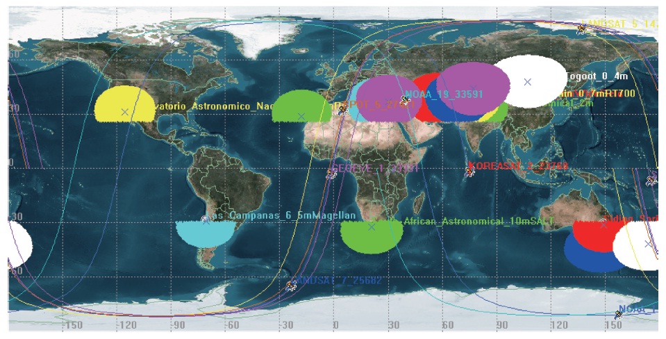
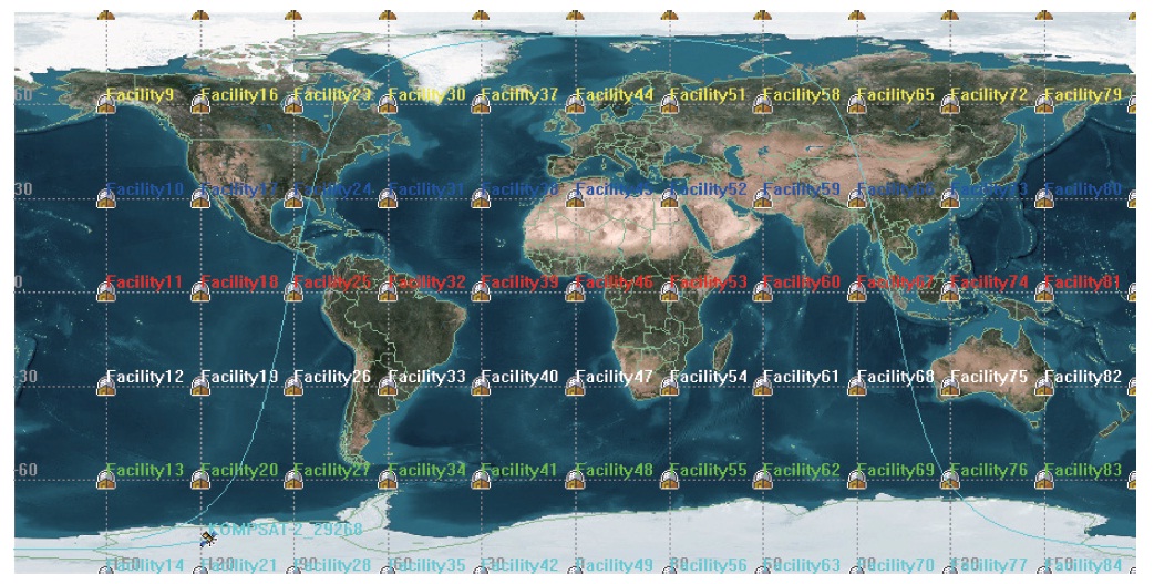
Basically, for all the simulation process, the maximum of the sun elevation angle was set to be -10 degree which is within the range of the nautical twilight. The lighting states of the penumbra and direct sun were set as the key constraints. The minimum of the observation satel-lite elevation angle was set to be 20 degree, which is the consideration of the light pollution and local sites. To an-alyze the visibility, 84 fictitious ground sites were set in a 30° interval for the earth’s latitude and longitude (Fig. 1). The entire simulation period was one year between Janu-
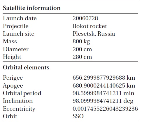
ary and December, 2010. The subject satellite was Korea multi-purpose satellite-2 (KOMPSAT-2). Table 1 summa-rizes the specification of KOMPSAT-2. The orbit propa-gator used for the simulation was the simplified general perturbations propagator (SGP4)1 that receives the two-line elements (TLE) provided by Analytical Graphics In-corporated (AGI) as the input orbital elements to predict the orbit.
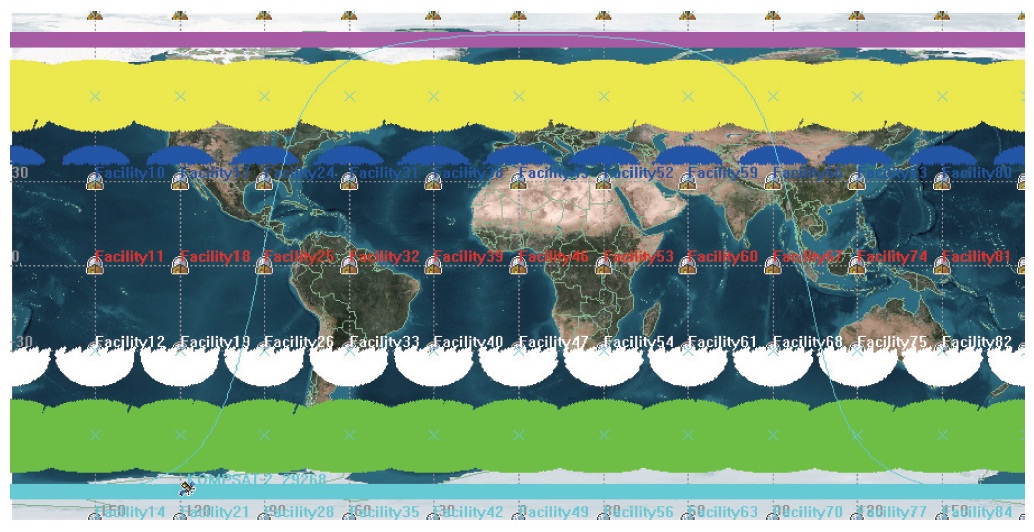
KOMPSAT-2, a domestic sun-synchronous orbit (SSO) satellite, was observationally visible only in the high lati-tude region (north latitude 34 degrees or higher or south latitude 30 degrees or higher) as shown in Fig. 2. For about 300 astronomical observatories including ground-based astronomical facilities and overseas observatories in the
[Table1.] KOMPSAT-2 satellite and orbit specification.*

KOMPSAT-2 satellite and orbit specification.*
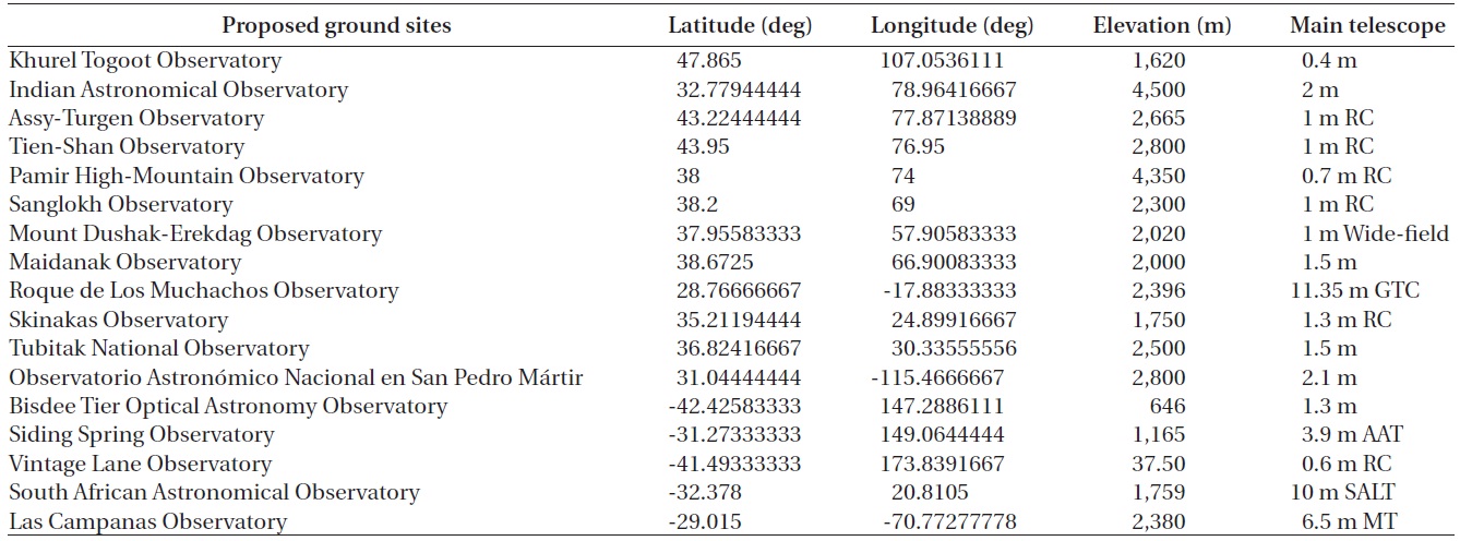
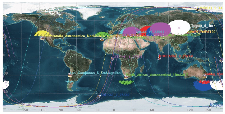
list of astronomical observatories2, we checked out the weather conditions, number of clearly sky days, and pro-vision of the communication and technological support. Excluding the candidate observatories in the countries that are difficult to approach because of international po-litical reasons, 17 candidate observatories were set as in Table 2. The visibility for the SSO satellites that are gener-ally known at the determined observatories was verified as shown in Table 3. The GeoEye satellite (Fig. 3) had the most narrow visibility range which was north latitude 35 degrees or higher or south latitude 40 degrees or higher, whereas the national oceanic and atmospheric adminis-
[Table 2.] Characteristics of proposed 17 ground sites (Moon 2011).

Characteristics of proposed 17 ground sites (Moon 2011).
tration-18 (NOAA-18) satellite (Fig. 4) had the widest visi-bility range which was north latitude 25 degrees or higher or south latitude 30 degrees or higher.
1http://www.stk.com/resources/help/online/stk/source/stk/vehsat_orbitprop_choose.htm [cited 2011 Feb 2]
2http://en.wikipedia.org/wiki/List_of_astronomical_observatories [cited 2011 Feb 7]
Before analyzing the visibility of the low earth orbit (LEO) satellites and middle earth orbit (MEO) satellites, we verified if it was possible to categorize currently op-erating satellites according to orbital elements, and if the categorized groups had the visibility characteristics.
[Table 3.] The specifications of several sun-synchronous orbit satellites.*

The specifications of several sun-synchronous orbit satellites.*
3.1 Categorization of Satellites According to Orbital Elements
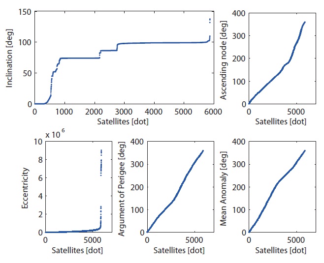
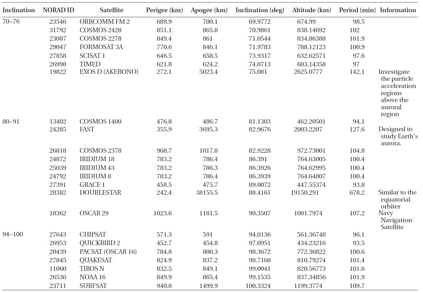
We chose 5867 satellites and unidentified flying ob-jects for which TLE were available in the collected data. The horizontal axis in Fig. 5 represents the satellites ar-ranged in order with respect to the orbital elements, while the vertical axis the orbital elements corresponding to the individual satellites. We arranged the satellites according to the orbital eccentricity, orbital inclination, ascending node, perigean declination, and the mean anomaly, and searched the orbital elements with which categorization might be performed. The result showed that the satel-lites were concentrated within a specific range of orbital
inclination (70-76, 80-91, and 94-100 degree) as shown in Fig. 5.
3.2 Visibility Analysis of the LEO and MEO Satellites
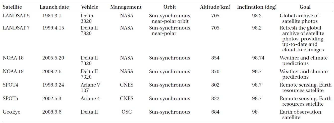
To verify orbital inclination can be a characteristic that may affect the visibility, we categorized the LEO and MEO satellites according to the orbital inclination and ana-lyzed the visibility for the 17 optimal ground site candi-dates. The total simulation period was one year between January and December, 2010. The specifications of the subject satellites are summarized in Table 4. The SGP4 or-bital propagator was used for each satellite.
3.3 The Visibility Analysis Result
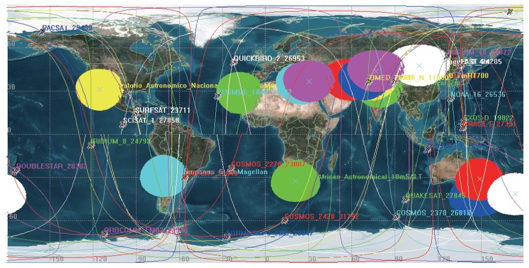
The visibility and the observation frequency of the 23 LEO and MEO satellites were independent on the orbital elements, and the difference was less than 1σ among the optimal ground site candidates. The visibility difference was negligible between the orbital communications flight model-2 (ORBCOMM FM-2) satellite (Fig. 6) having the smallest orbital inclination and NOAA-16 (Fig. 7) having the greatest orbital inclination. None of the other satellites was affected by the orbital inclination. Thus, it is difficult to categorize the satellites in view of the orbit and deter-mine the optimal ground site with reference to a general standard. Simulation needs to be performed for domestic satellites and the satellites that are to be launched in the country according to the characteristics and properties of the mission which is the optical surveillance and tracking of the domestic satellites.
[Table 4.] 23 satellites representing typical LEO and MEO orbital characteristics*
23 satellites representing typical LEO and MEO orbital characteristics*
4. VISIBILITY ANALYSIS OF DOMESTIC SATEL-LITES ON PROPOSED 17 GROUND SITES
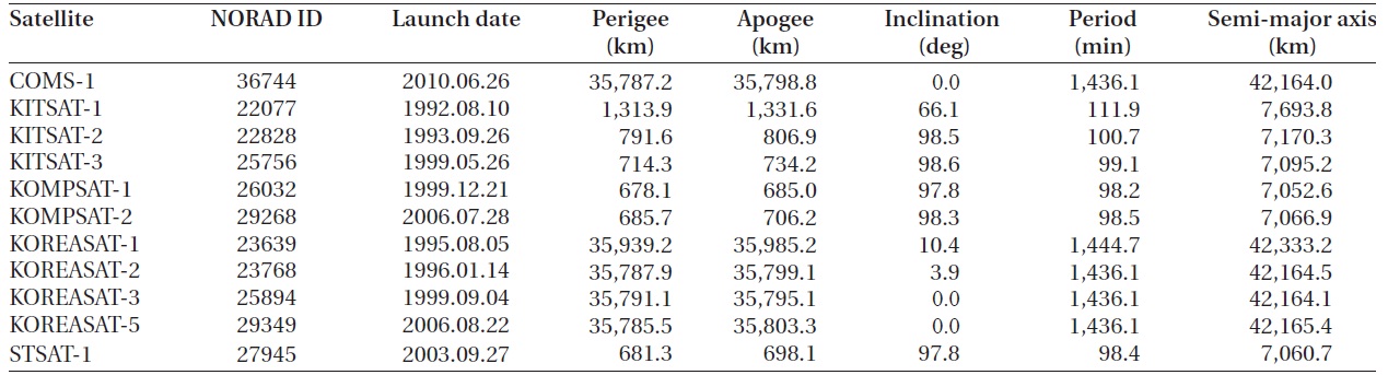
The visibility of ten domestic satellites was analyzed for the 17 optimal ground site candidates. The total simula-tion period was one year between January and December, 2011, and the simulation was performed for one extra day for each equinox and solstice (the spring equinox, sum-mer solstice, autumnal equinox and winter solstice). The specifications of the subject domestic satellites are shown
[Table 5.] Specification of the launched domestic satellites.*

Specification of the launched domestic satellites.*
[Table 6.] The number of 33 cases for the combination of 5 ground sites for best visibility.
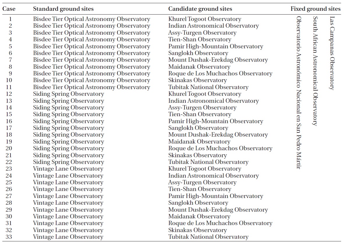
The number of 33 cases for the combination of 5 ground sites for best visibility.
in Table 5. To make the final determination of the five op-timal ground sites, we fixed ground sites that solely had a local superiority to the surroundings (Las Campanas Observatory, South African Astronomical Observatory, and Observatorio Astronomico Nacional en San Pedro Martir), made 33 combinations with the observatories concentrated on the southern hemisphere (Bisdee Tier Optical Astronomy Observatory, Siding Spring Observa-tory, and Vintage Lane Observatory), and compared them as shown in Table 6. The orbits of the domestic satellites
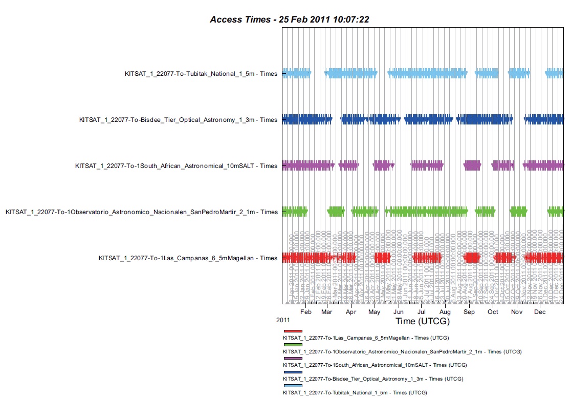
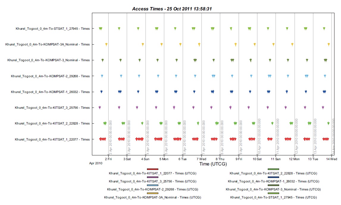
were predicted using the SGP4 orbit propagator. The sim-ulation was performed with respect to the ten domestic satellites in connection with the 33 combinatorial cases, resulting in 330 visibility analysis diagrams as shown in Figs. 8-10.
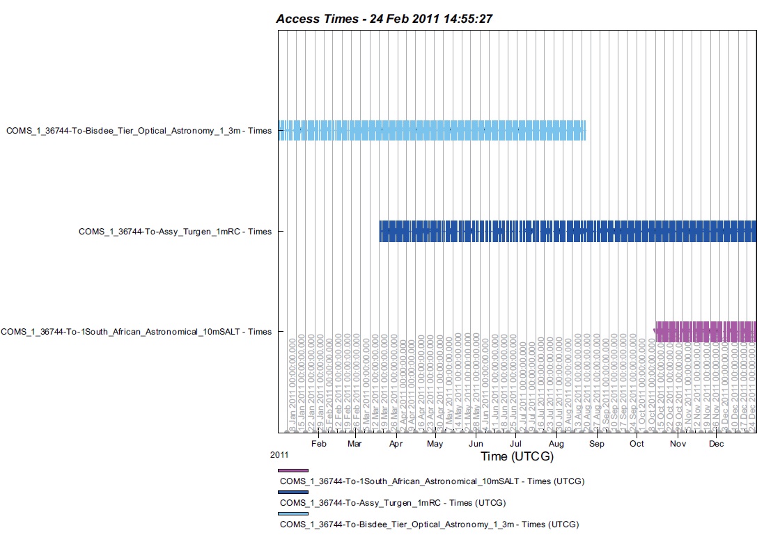
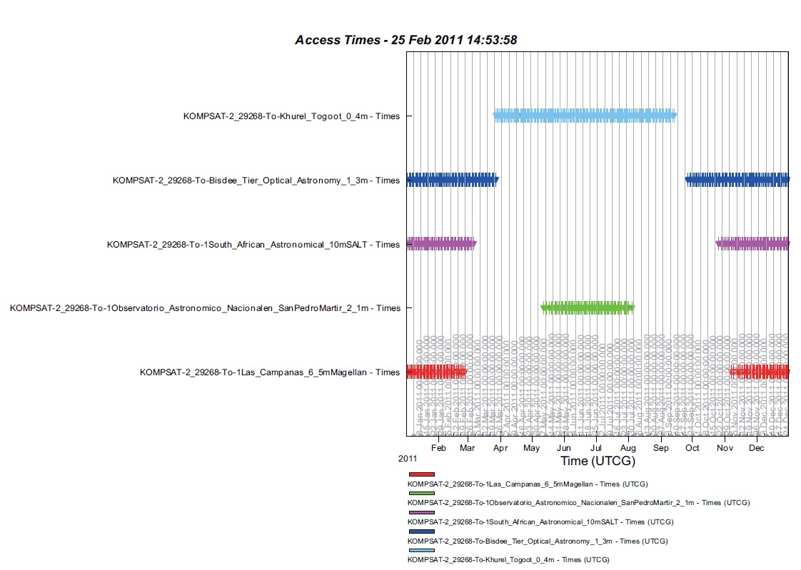
In these figures, the horizontal axis represents the ob-servationally visible time, while the vertical axis the ob-servatories determined for the satellites. All the 33 cases showed the difference less than 1σ, but we found follow-ing differences by comparing the observatories having a similar visibility trend. Different from our expectation, a better result was found, not in the observatories that had a local superiority and thus had been included in all the combinatorial cases, but in the observatories that had not been included. Khurel Togoot Observatory showed the observationally visible time 1.2 times longer than that of Observatorio Astronomico Nacional en San Pedro Martir in summer. Bisdee Tier Optical Astronomy Observatory and South African Astronomical Observatory showed a longer observationally visible time in winter than that of Las Campanas Observatory that was compared to-gether (Fig. 8). In the third case where the communica-tion, ocean and meteorological satellite-1 (COMS-1) was simulated, Assy-Turgen Observatory showed a far longer
observationally visible time than that of other observato-ries (Fig. 9). In the 11st case, Korean institute of technol-ogy satellite-1 (KITSAT-1) seemed to have a similar vis-ibility for the five determined observatories, but Tubitak National Observatory showed the observationally visible time 1.2 times longer than that of Astronomico Nacional en San Pedro Martir or Las Campanas Observatory (Fig. 10). Hence, we finally determined the five observatories (Khurel Togoot, Assy-Turgen, Tubitak, Bisdee Tier and South Africa) as the optimal ground sites.
5. FEASIBILITY ANALYSIS OF SERIES OBSERVA-TION BASED ON GROUND TRACK OF FICTITIOUS SATELLITES
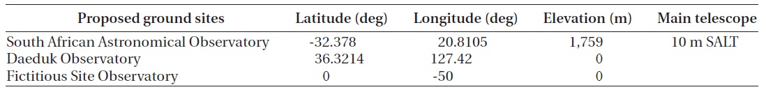
Series observation within 24 hours in the process of maintaining the ephemeris through optical observation may greatly help to maintain the ephemeris precision. To analyze the continuous feasibility through the ground track, we set up the Daeduk observatory (DO) and South African astronomical observatory (SAAO) at which series observation may be feasible on the basis of the latitude. Then, we set fictitious sites (FS), considering the series
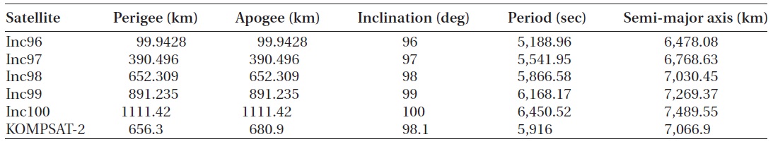
observation feasibility with the DO to the full (Table 7). The simulation period was for one day and three days on each equinox and solstice (the spring equinox, sum-mer solstice, autumnal equinox and winter solstice). The specifications of the subject satellites, five fictitious sat-ellites for each orbital inclination as well as KOMPSAT-2, are presented in Table 8. KOMPSAT-2 was used as the reference to compare the fictitious satellites with an ac-tual one. In the simulation, the SGP4 orbit propagator of which TLE is updated in real-time was used for KOMPSAT-2. Since the TLE had to be manually put in to the other fictitious satellites, without automatic TLE update, we employed the J4 Perturbation orbit propagator3 that allowed the orbit propagation from the initial input orbit-al elements. J4 Perturbation (second-order) propagator accounts for secular variations in the orbit elements due
[Table 7.] Characteristics of chosen 2 ground sites and 1 fictitious ground site.
Characteristics of chosen 2 ground sites and 1 fictitious ground site.
[Table 8.] Specification of the 5 fictitious satellites and KOMPSAT-2.*
Specification of the 5 fictitious satellites and KOMPSAT-2.*
[Table 9.] Series observation frequency during the day at equinoxes.

Series observation frequency during the day at equinoxes.
to Earth oblateness, which does not model atmospheric drag or solar or lunar gravitational forces.
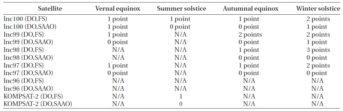
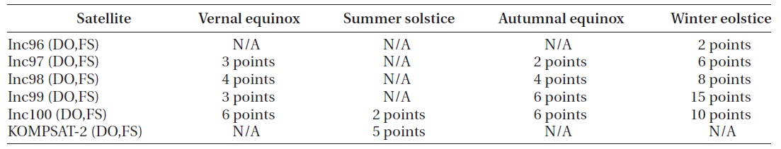
The simulation result showed that the maximum number of times for series observation per day was one between DO and SAAO. The mean number of times for series observation per day between DO and the FSs was about one as shown in Table 9, although there was some exceptional cases when the maximum was three times in a day (orbital inclination 98 degree on the winter solstice). Here, 1 point represents the case where series observa-tion was performed for one time, while 0 point represents the case where the observation was possible but not con-tinuously. In the case of three-day interval simulation, the number of times for series observation between DO and FS was relatively greater on the winter solstice, and the number of times for observation was the greatest for the fictitious satellite whose orbit inclination was 99 degree, as shown in Table 10. Therefore, series observation is one factor to increase the precision when maintaining the
[Table 10.] Series observation frequency during 3 days at equinoxes.
Series observation frequency during 3 days at equinoxes.
ephemeris through optical observation. However, it does greatly affect the determination of the optimal ground sites, and is not appropriate as a requirement for enabling the ephemeris maintenance through optical observation, since its actual frequency is not high.
3http://www.stk.com/resources/help/online/stk/source/stk/vehsat_orbitprop_choose.htm [cited 2011 Feb 2]
The EV analysis was performed to verify whether or not the observation data sufficient to maintain the ephemeris could be acquired from the finally determined optimal ground sites.
EV is defined as the percentage of the actual observa-tionally visible time, assuming the number of observa-tion points needed for the ephemeris maintenance for two weeks of satellite flying to be 600 and the length of the time when the 600 points are continuously visible to be 100% (Jo 2011). Eq. (1) is the equation to calculate EV. The observationally visible time shorter than 60 seconds is excluded when calculating 0
where EV denotes effective visibility, EV the Total sum of observationally visible passing time over each site which is longer than 60 second per piece in two weeks.
The observationally visible time during two weeks in each season was analyzed for the five optimal ground sites (Khurel Togoot Observa-tory, Assy-Turgen Observatory, Tubitak National Observatory, Bisdee Tier Optical Astronomy Observatory, and South African Astronomical Observatory) among the ground site candidates shown in Table 2. The simulation period was for two weeks from the first day to the 14th day of January, April, July and Oc-tober in 2010. The subject satellites were nine domestic LEO satellites including KOMPSAT-3, KOMPSAT-3A and KOMPSAT-5 that are to be launched. The specifications of the subject satellites are shown in Table 5. In the cases of the satellites to be launched, the simulation orbit was predicted using the J4 Perturbation orbit propagator to which nominal orbital elements are put in, while the SGP4 orbit propagator was used for other satellites. Fig. 11 shows the result. The horizontal axis in the figure rep-resents the observationally visible time, and the vertical axis the individual satellites determined for each of the optimal ground sites.
With the observationally visible time obtained as the re-sult of the simulation with respect to each satellite, 0
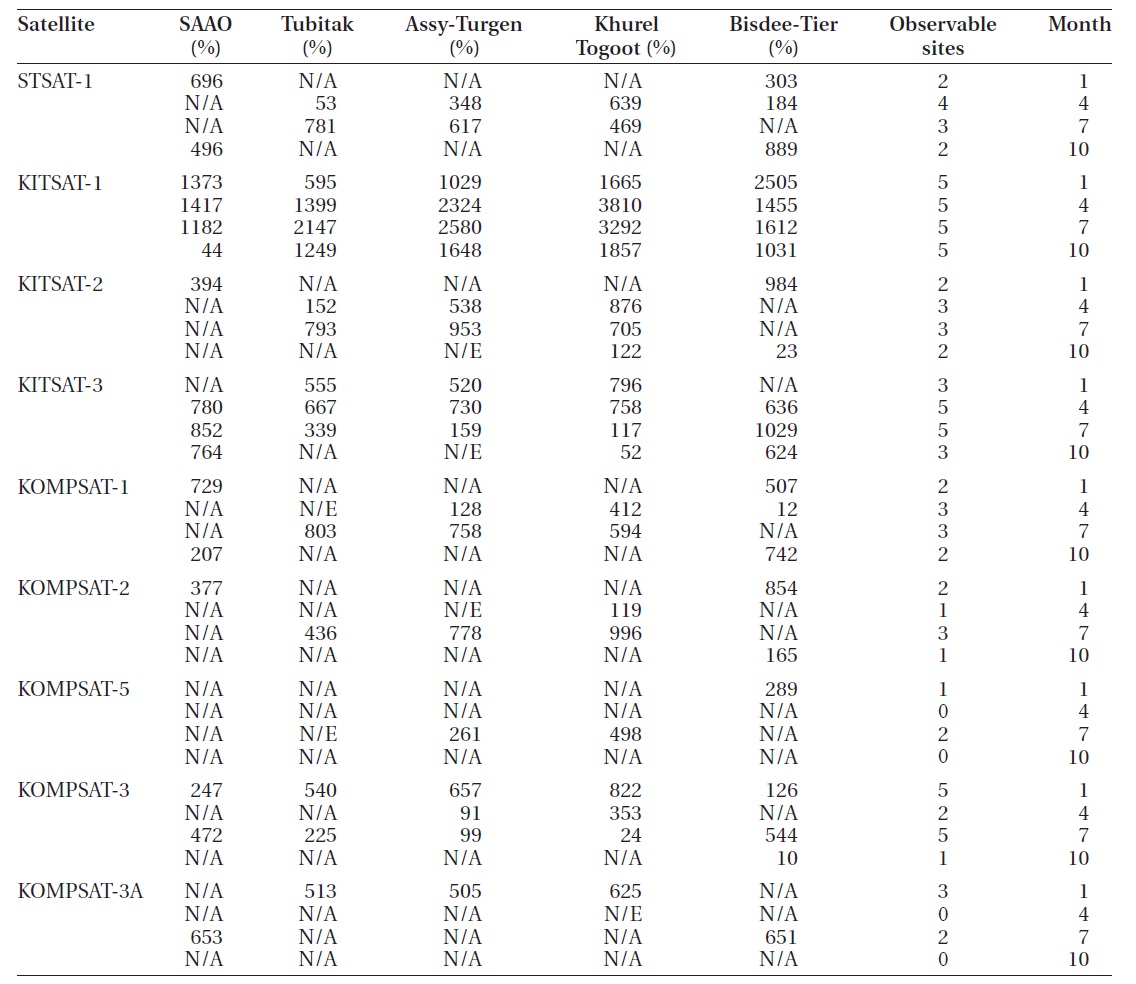
Table 11 shows the EV calculation result for the optimal ground site for each domestic satellite. Firstly, it should be verified whether or not the EV meets the requirements of the optical observation data of the domestic satel-lites, including the satellites that will be operated in the future, needed for the maintenance of the ephemeris at the five determined optimal ground sites. Excluding KOMPSAT-3, KOMPSAT-3A and KOMPSAT-5 that are to be launched in the future, the observation data needed for the maintenance of the ephemeris are acquired averagely at three out of the five determined optimal ground sites
over a year. Particularly, Bisdee Tier Optical Astronomy Observatory has a great significance even among the optimal ground sites, since its overall EV is high and the observation is possible even when it is difficult at other ground sites. Among the SSO satellites, the observation in April and October may be difficult with KOMPSAT-3 and KOMPSAT-3A that are supposed to move along the ground track in a similar pattern with that of direct sun as well as KOMPSAT-5 that is supposed to move along the dawn-dusk orbit. Since the accurate orbital elements of the domestic satellites that are to be launched could not be identified, the orbit propagation was performed over an excessively long period of time depending on the nominal orbital elements in the simulation process, and thus the accuracy and reliability of the simulation results regarding the visibility were not high. For this reasons, even the simulation over a year with other candidates in addition to the five optimal ground sites would not en-able to make right judgments. Therefore, the optical vis-ibility over 80% could be obtained with respect to the do-mestic satellites at the selected optimal ground sites. The EV will be increased if the actual orbital elements of the domestic satellites are included in the future.
To perform the optical surveillance and tracking of do- mestic satellites, we determined five optimal ground sites from 17 candidates, and investigated whether or not the observation data sufficient to maintain the ephemeris could be acquired from the finally determined optimal ground sites. Before determining the optimal ground site candidates, the optical observation limiting factors of the domestic SSO satellites were identified, and the result showed that the candidates on high latitudes (north lati-tude 25-34 degree or higher, south latitude 30-40 degree of higher) had an advantage for the observation of the SSO satellites. The LEO and MEO satellites were catego-rized according to the orbit inclination and the visibility was compared with each other. The result showed that the visibility and observation frequency were indepen-dent upon the orbital elements including orbit inclina-tion, and the difference was less than 1σ among the opti-mal ground site candidates. Thus, we found that it is more important to analyze the visibility at the optimal ground sites for the domestic satellites and the satellites to be launched in the country than analyzing any other factors. As a result, five ground sites (Khurel Togoot, Assy-Turgen, Tubitak, Bisdee Tier and South Africa) were finally deter-mined. The series observation feasibility at two or more optimal ground sites, but the actual frequency was low. Thus, the series observation feasibility was not appropri-ate as a requirement for ephemeris maintenance. The EV was analyzed for the five determined optimal ground sites to verify whether or not the observation data suffi-
Effective visibility of observation site candidates for first session of January April July October.
cient for the satellites to maintain the ephemeris could be acquired. The result showed that the observation data sufficient to maintain the ephemeris could be acquired at all the five determined optimal ground sites and that the EV was higher than 80% for the domestic satellites. When considering the sites for the optimal ground sites in the process of establishing the optical telescope system for space object surveillance and tracking, the five sites that were found in this study to have high visibility and EV may be selected preferentially, if other conditions are the same including the basic infrastructure. Additionally, the optical observation system could be established on the basis of the assumption that the determined optimal ground sites are located at the most advantageous posi-tions for the optical observation of the domestic satellites and that the data acquired from the observation are suf-ficient to maintain the ephemeris.