This article focused on the environmental changes on atolls in Micronesia. First, we considered the problem. Second, we designed research that focused on the impacts of environmental changes especially in relation to globalization and global warming in the Federated States of Micronesia (FSM). The results were in accordance to the hypotheses that globalization had impacted prominently in communities on main islands and impact was lessened with increased distance from the centre. The fact that the islands are remotely situated and thus, in theory, do not have much outside influence, has not alleviated them from having societal concerns. The earth's environmental change is causing an impact on the main islands as well. This has been governed by distinctive characteristics in their geographical, regional, and contents. Moreover, they showed stronger concerns about impacts on the environment than globalization. A set of questionnaires was used as the principal assessment method to quantify the concerns relating to the environmental changes.
THE IMPACTS OF ENVIRONMENTAL CHANGES ON PACIFIC ISLANDERS
>
Globalization and the new paradigm of the Pacific Way
When we consider the present and future environmental changes in the Pacific Islands, we can see that there are two indispensable factors that cause huge impacts on the life-style of islanders. One factor is globalization and the other is climate change. Globalization is not only the problem of urbanization and modernization trends. There are also conflicts of urbanization versus country or village life, modernization versus tradition, monetary versus subsistence economic structure, exogenous development versus endogenous development, Papalagi (Euro/American) versus Tuiavii (Pacific) (Scheurmann 1920), continental versus oceanic islands, and competitiveness versus co-existence as a way of life for the Pacific islanders. Their life-style is confronted in various areas and they are faced with big challenges such as the digital divide strategy for the information revolution, monetary and consumer education to tackle the problem of more than necessary dependence on consumption, job opportunities and empowerment for income generation, and local and vernacular culture promotion to meet with global cultural flux. Other challenges include local and traditional wisdom preservation like food knowledge and customs to meet with imported food flux, a reproduction skill renaissance to be protected from exploitation by overuse of commercial activities, creation of u-turn circumstances by means of immigration following higher education, and community promotion against de-population and urbanization problems.
The new paradigm of the Pacific Way needs to be established in order to meet the storm of globalization for Pacific Islanders. This new paradigm is not cohesive with the old days, but will be beneficial for future generations. This shall be established upon their essential way of life and spirits more than equal value exchange system, competitiveness and overuse of resources; that is sharing, reciprocity, redistribution, consensus (long discussion), peace and order under authority, re-productiveness, sustainability, new identity, and endogenous decision making procedure (Nagashima 1987).
Climate change in the Pacific Islands is not only global warming and its effects, but also a few other major factors such as abnormal weather, El Nino, and La Nina. Climate change is accelerating and this is amplifying the collapse of subsistence/production foundations. The rise in ocean levels caused by global warming, understood only by average sea levels, is only one of these problems. Real problems are more severe.
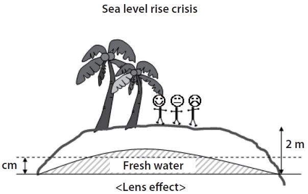
If the Intergovernmental Panel on Climate Change (IPCC) forecast of an 88 cm rise in sea level by the end of 21st century comes true, how are the residents of atolls to survive? Consider the situation after one century. Islanders will lose almost all of their land to the sea. We want to emphasize that a flat 20 cm sea level rise will destroy the ecological basis of freshwater. They include the killing of creatures on the shore and on the sea surface by El Nino which causes coral damage as well as 'sea burning' by both continuous droughts caused by high temperatures and temporary drops in the sea levels.
The thinning of the fresh water lens by rising sea levels causes vegetation decline preventing ecological and sustainable development. Land damage from salt water during La Nina which causes a temporary sea level rise with low pressure, shall occur at most levels of sea rise. An increase of powerful typhoons, which may be at the lowest level of pressure, with serious damage by rainstorms and flood-tides, is more likely as compared to before due to the rise in sea level. Sea level rise makes coastal management risky and, if the factor of tsunami is added, a sea level crisis will result in damage and destruction (Fig. 1). We can see an existing escalation of risky phenomena by El Nino and La Nina occurring at most levels in both directions (Lander 2007).
In some places like Majuro, there is not only climate change, but also construction of an artificial seaside infrastructure and dirty water caused by urbanization. These two combined influence ocean sand production, movement, and loss. This creates a risky situation that makes it difficult to protect beaches. The resultant problems of these many huge risks cause social unrest, and anthropological spoil feeling against other industrially advanced and civilized societies. Anthropological conflicts are of a concern on a global scale because of global climate change. A new global wisdom is required because of these climate disturbances caused by human activities. This new wisdom may enable humans to bypass any negative results. Therefore, we must develop a new anthropological attitude to meet these ‘anthropological climate changes’ (Kawai and Nishimura 2005, Nagashima 2007b).
How can we prepare for these risks? We need comprehensive methods for every category of risk management. The islanders can also contribute to the global activities, however, they are the first victims and so must deal with their multiple risks first. Risk management methods can be effective. However, detailed discussion is beyond our scope. We used a comprehensive human-environmental 5-ware model. For example, an endurance system against salty water sacrifice, fresh water reservation and disaster prevention can be considered in detail. Here are some examples for the 5-ware model: hard-ware in the use of civil engineering, safety nets as soft-ware, salt endurance species as ecological-ware, empowerment as spiritual-ware, and cultural promotion of risk management by community as human-ware. Each specialist can support in detail and cement these 5 wares or comprehensive managerial units (Nagashima 2000a). These combinations are required on every small island in every atoll and should take priority in the world.
BACKGROUND AND RESTRICTION OF SUSTAINABILITY RISKS IN MICRONESIA
Pacific atolls are under the threat of environmental change - specifically from globalization and climate change. After Micronesia concluded the Compact of Free Association with the United States in the 1970s, cash transactions were accelerated and the society of economic consumption, which is separated from the production structure, was expanded. This society of economic consumption gradually came to stay, laying out a critical foundation for maintaining the community life economy. Rice, wheat, imported processed meat and canned fish, which spread into people's lives a long time ago, are still rocking the foundations of their economic structures of life. In addition, they are in crucible because of the competition, surplus production, mono-culture products, and cash economic circulation/cash valued standard on globalization. In this area where cheaper goods are imported and high value-added products are not made, the separation in structures between production and consumption is accelerating. The local economy is inclined towards a MIRAB economic structure (migration, remittance income, foreign aid, bureaucracy). Besides the accelerated population movement, the cash economy/consumption driven economy structure is accelerating more and more. In addition, reducing funds from the Compact of Free Association, which is the main fund source, makes the situation a hopeless crisis. In the case of Nauru and Fais, there is an additional handicap of land dilapidation by phosphate mining for the benefit of advanced countries (Nagashima 2008, 2009a, 2009b).
TOWARD A POST MIRAB ECONOMY AND A NEW CIVILIZATION
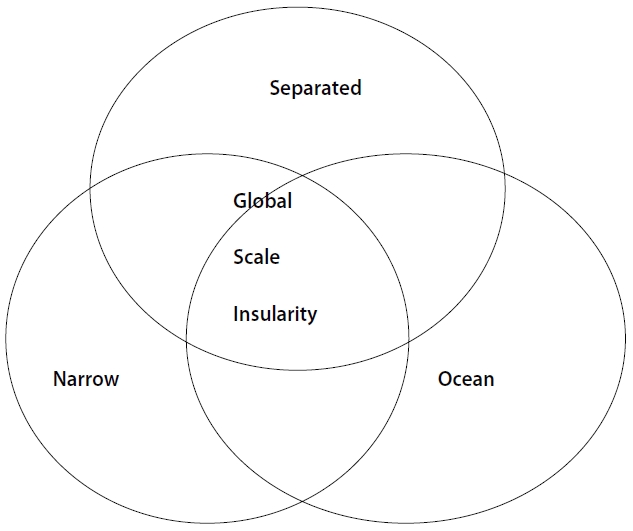
If their future vision is focused on conquering insularity economic problems under the island complex (Fig. 2), global economic competition will undergo immensely difficult challenges. One challenge is 'conquering the problem of distances': hardships caused by the vast ocean surface which occupies one third of the earth, and by high fuel cost, information links by satellite or line should be part of the evolution of technology for an islander's life. However, the islanders now face problems of the digital divide and high cost requirements. Some people may insist that bio-engineered products are the best methods for bridging the gap. Bio-engineered products should be left to other competitive markets in their best circumstances. Another challenge is that of 'conquering the problem of smallness': their competitive commercial products are limited, and scale merit shall be great handicap for them. Thus, alternatives are required. 'Small is beautiful' and 'slow life' strategies need well trained quality touch services and the promotion of the original culture. However, these do not always lead to direct high value adds economy. A third challenge is 'conquering marine problems': it is becoming ever so difficult to prevent natural hazards. The endogenous marine industry is not competitive enough to the world market.
Charges for fishing in other piscatorial areas for exclusive economic zone (EEZ) are exogenous developmental
method. To be successful, marine tourism must be in harmony with the local fishing industry as well as nature reservation and they must be respectful of vernacular culture. They have to establish local and global rules (GLOCAL in Japanese English). Fig. 3 is the case of glocal challenge using local resources. However, these paths are still on the way to industrial and post-industrial civilization.
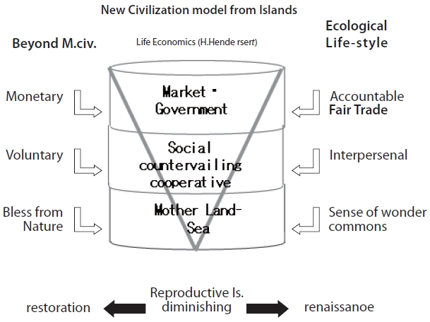
The locals and we professionals have to prepare and create alternative paths for the next civilization: a so-called 'life-nomic civilization'. Life economy is divided into three class layers (Fig. 4). The first class layer is ecology economy. The second class layer is inter-personal activity economy. The third class is market/government economy. Can we establish the global model throughout the small Pacific islands, especially the isolated islands?

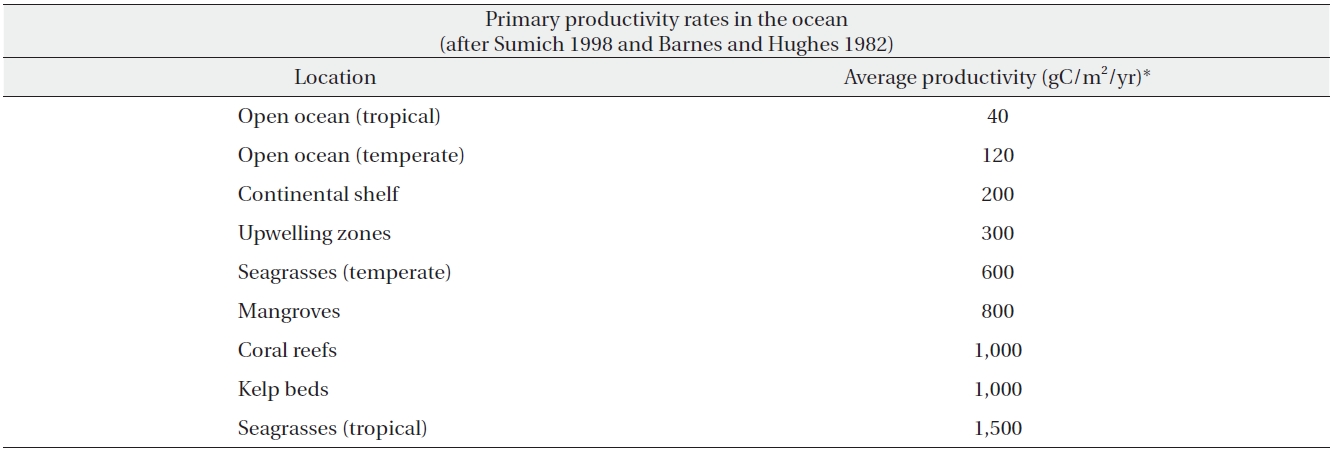
Primary productivity in the ocean (Source: Rapaport M. 1999. The Pacific Islands: Environment and Society. Bess Press, Honolulu, HI, p 111)
The developmental path to promote a 'life-nomic' economy is the royal road based on a subsistence economy for the Pacific Islanders and us (Nagashima 2000c). 'Subsistence sustainability' embraces a subsistence economy for everyday life and sustainability as key concepts for their future, more so than the traditional path. However, their recognition and initiative are not well-established and even their sustainability conditions are confronted by many risks brought on by globalization and climate change. This is the crisis of their future - recognition and awareness of these issues are not measurably noted by themselves. However, dominant structures of cash economy prevent their turn pike path. We have to establish a fair trade structure with the Pacific Islanders to overcome low cost competition in the world market. Non-Profit Organization (NPO) establishments in the second class layer shall be a co-governance revolution. A mutual help system in traditional rule shall work more effectively with inner-networking and inter-networking, sometimes with global linking.
Volunteer guides and activities shall be changed to professional work for a valuably respected fee. Local knowledge and a traditional training system shall be paid for by eco-money or community-money (reciprocity cycle) with appreciation.
Re-evaluation and planning by ecological productivity measure beyond a monetary system and a short term measure is the best effective global sustainability path rather than focusing on local benefit (Nagashima 2000b). This may be the best policy for global warming by the Pacific Islanders. The Kyoto protocol and a carbon tax strategy shall be supportive of this way beyond and across the global market. Table 1 shows these productivity indexes. We need to add more indexes and measures for concrete assessments in each Pacific island. Eco-tourism is not almighty, however if we can make a better arrangement, mutual understandings can be enforced.
Multiple uses of strategy and technology are another alternative for bio-zero emission. Not only are their resources utilized, they make less imports and in some cases can export with advanced technology by university and academic contribution or marketing (e.g. a one-village-one-produc movement)(Fig. 3).
Kagoshima University Research Centre for the Pacific Islands has been investigating the effects of global warming on the small islands and atolls in the Pacific Ocean since 2005. The investigations through the years have shown global warming manifestations throughout the regions. Along with the significant results from this continuous research, further problems have become elucidated that the atoll region has also been greatly affected by other factors. It is not clear as to whether the factors are acting independently or whether it's the result of certain factors interacting (Yonekura 2000). Therefore, it has become clear that the other factors/causes need to be considered in future research.
Taro is one of the main crops cultivated in the Federated States of Micronesia (FSM) and it is a staple in the Micronesian diet. Fresh water is required in taro cultivation. If a tidal wave hits the land, the taro patch will be damaged from the salt. However, after examining the eating habits of the people of the FSM in detail, a change in cultivation structure is observed due to a combination of dependence and reliance on imported foods from the outside such as rice and bread. Another example of accelerating change is the dependency on the monetary economy, which is widely used in seafood markets.
For example, taro is a major agricultural produce in the Micronesian area, and it is a staple in the diet. It is known that taro patches are damaged from the salt when tidal waves hit the land. There has been a recent change in the agricultural structure due to multiple effects of the dependence and reliance on imported foods like rice and bread. This can be seen by examining the Micronesian people's eating habits in detail. The seafood markets have increased their dependency on a monetary economy, and there is an accelerated rate of change. It is not clear as to whether this phenomenon is the result of interactive factors strongly influencing each other or that of individualized phenomena. For this reason, in order to investigate the effects of global warming, it has become clear that other factors that largely influence nature and society also need to be considered. It is thought that the factor that largely influences the small islands in particular is globalization. Based on and alongside preliminary research, it has become imperative to conduct comprehensive and quantitative research into how the two factors - global warming and globalization - influence and impact the Pacific Ocean small islands and atolls and to pinpoint what factors influence the socio-economic system and natural environment.
The FSM is a vast island nation located to the north of the equator, consisting of 607 islands that are scattered in a stretch of 3,000 kilometers from east to west. It has had an important economical relationship with Guam, a U.S. territory, over the years. Within the country, state capitals resemble that of Guam: namely, Colonia (Yap State), Weno (Chuuk State), and Palikir (Pohnpei State). It is hypothesized that the degree of global influence on economy, society, and culture is dependent on the distance from Guam and from each state capital to the region in question. Presuming Guam is at the heart, the FSM forms the periphery. The concept of the "centre-periphery" theory claims that, generally, the closer an island is to an urban centre, the more powerful the central influence has on the location. Likewise, the central impacts decrease with increasing distance away from the core. If we replace "centre" and "periphery" with Guam and the FSM respectively, this suggests that the closest state to Guam, Yap State, is seen to be influenced the strongest. Correspondingly, the furthest state from Guam, Kosrae, is influenced the least. The "centre-periphery" relationship also applies to islands within a state. A smaller island closer to the state capital on the main island is subject to a stronger globalization impact, and islands that are further away will remain more traditional.
In terms of global warming, warmer global temperatures manifest as higher occurrences of phenomena such as cyclones. However, individual islands of the atolls have relatively similar drift.
The advantage of investigating the Micronesian atolls is that the islands are geographically distributed from west to east. This eliminates the latitude as a factor contributing to environmental change. In addition, from an evaluative point of view, it is possible to evaluate the effects of Guam - the centre and 'dispatch centre' of globalization - as one country. By targeting the Micronesian atolls as our research region, the factors that would have needed consideration are simplified and we were able to create a clear approach to the above stated aims.
There have been a number of other region-specific academic research studies with many fruitful outcomes (Aoyama 1995, 1996, 2001, 2003). Unfortunately, many have had a biased approach skewed towards scientific or artistic discipline. In some cases, despite having a balanced structure, the studies have been independently investigated and, therefore, suffer from segregated research aims which create further issues. This study, on the other hand, has completely integrated each data set to elucidate the environmental effects on the atolls by having four research focal points - ocean, land, culture, and economics. Our research also quantified all the results by statistical process. The research will also demonstrate the overall technique of having a concrete study in academic research.
The Outer Islands, which are portrayed as being more traditional, are at risk of changing identity. The degree of availability and prevalence of information such as the use of internet will inevitably lead to colossal societal restructuring. As mentioned above, a big sphere of "central-peripheral" connection exists between Guam and the FSM as well as a "central-peripheral" connection within each state between the state capital and outer islands. This will be used as an underlying structure for qualitative research to elucidate the four indices to indicate the degree of impact by globalization. It was carried out in the three regions that are geographically closest to Guam, from the order of closest to furthest, Yap State, Chuuk State, and Pohnpei State.
The appraisal of individualized environmental impacts will be examined through shared relationships between these individual data, region-based totals, and their comparisons. We aim to accomplish comprehensive and integral regional research in qualitative appraisal and quantitative data collection.
Across two field seasons, two states of the FSM were investigated- State of Pohnpei in 2007 (U village on the main island, Mokil Atoll, and Pingelap Atoll) and Yap State in 2008 (three villages in Yap Proper- two adjacently located villages Gachpar and Wanyan and the southern district of Gilman, along with two Outer Islands- Falalop [or Faraulep] Island of Ulithi atoll and Fais coral island). Based on the preliminary research conducted in Chuuk State in 2005-2006 (predominantly covering the main island Weno, Piis Island, Romanum Island, and Falapagues Island), the present research aimed to typify the impacts of environmental changes on the atoll ecosystem (Nagashima 2007a).
The preliminary pre-investigative coordination at the research sites was carried out based upon fundamental data from central government offices on Pohnpei main island and Yap Proper. Unfortunately, the 2007 research site had to be rapidly changed due to a mechanical breakdown, a propeller breakage, which hindered the only transport to the planned destination, the Outer Islands of Yap. The investigation had to be swiftly changed to another location planned for 2008 research due to this unlucky circumstance. These new study areas were two Outer Islands of Pohnpei, the Pohnpei mainland coastal village, and families with high-school students living in the state capital.
The data collected at each site ranged from socio-economic statistics, evaluative data on the regional industry and their standards, interviews and questionnaires during home visits, collective regional evaluation, and collection of data specific to each research field.
It is important to obtain quantitative data in environmental changes in discrete social environments and natural environmental ecosystems - sanitation (animal borne diseases), agricultural produce (crop and fruit cultivation), social and governance structures, cultural and religious structures, life-economy relationship, lifestyle structure, marine animals (e.g. corals), and marine plants (e.g. seaweeds). Furthermore, it was possible to obtain fundamental data of the whole ecosystem of each individual atoll community and the transformations of these ecosystems. The discrete and concrete collection of the environmental change data derived from large-scale disasters such as El Nino and typhoon damages, support received for the recovery from these devastations, change in food and oil prices, disorder and chaos in transporting goods, and information development are highly significant.
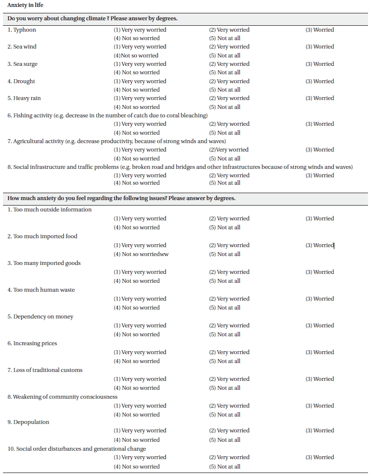
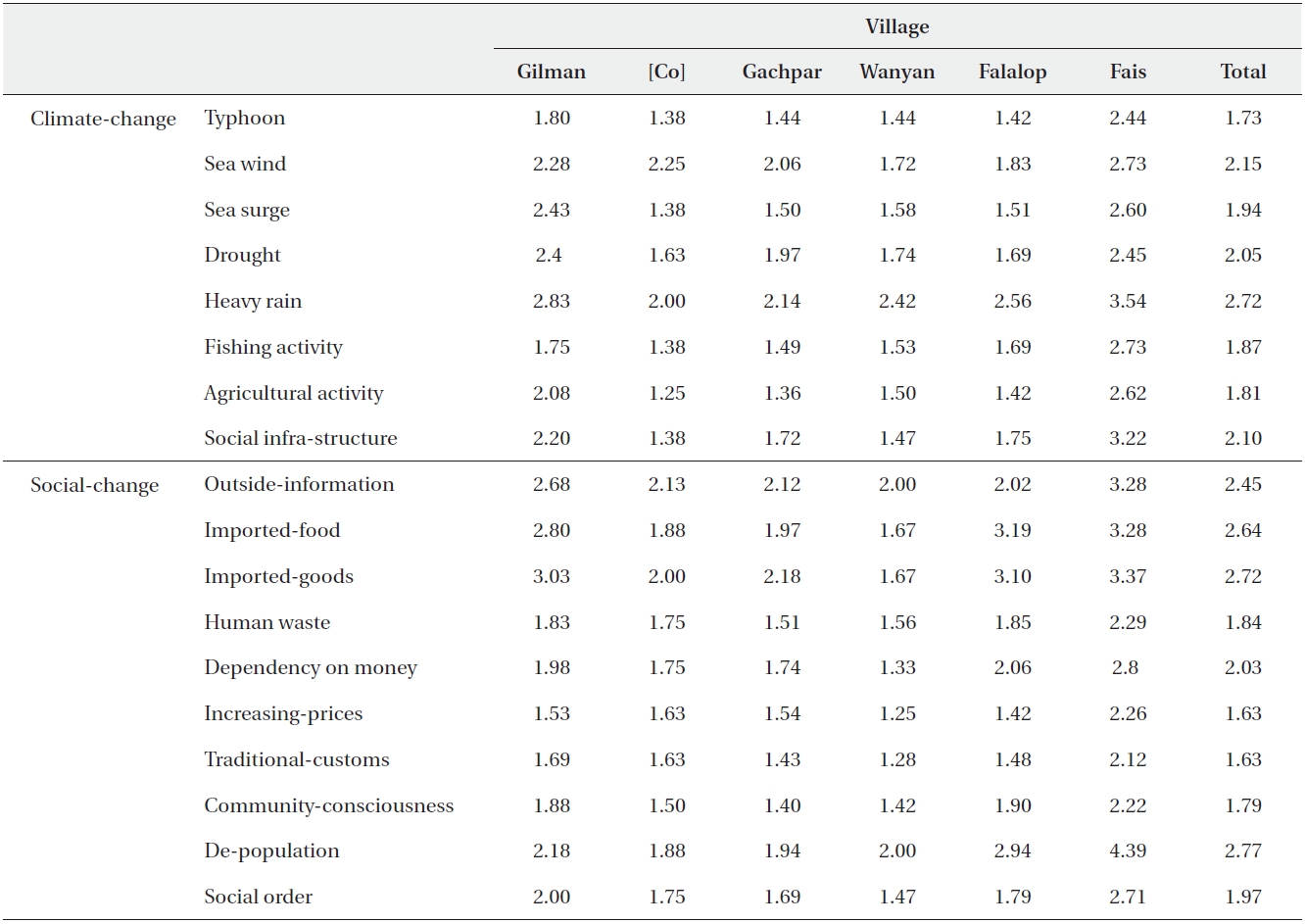
We conducted research by each specialty and questionnaire research at each villager's household by the research team: Kawai Kei (1), Kuwahara Sueo (2), Onjo Michio (3), Noda Shinichi (1), Nishimura Akira (2), Tominaga Sigeto (1, 3), Terada Ryuta (4), Hidaka Tetushi (3), Nagashima Shunsuke (1) (1: Research Center for the Pacific Islands, Kagoshima University, 2: Faculty of Law, Economics and Humanities, Kagoshima University, 3: Faculty of Agriculture, Kagoshima University, 4: Faculty of Fishery, Kagoshima University).This paper is limited in the research results gathered by the author's field studies - specifically, the part of the questionnaire concerning the villagers' anxiety regarding the environmental changes and checking the differences of the village's community by social circumstances (Table2).
[Table 2.] Anxiety questionnaire regarding globalization and climate change

Anxiety questionnaire regarding globalization and climate change
RESEARCH RESULTS AT POHNPEI STATE
The requirements for administering the questionnaires targeted families with local high-school students living in the most urbanized capital, inhabitants of Pingilap atoll and Mokil atoll off Pohnpei State, and the coastal U village inside the coral reefs which engulf the mainland.
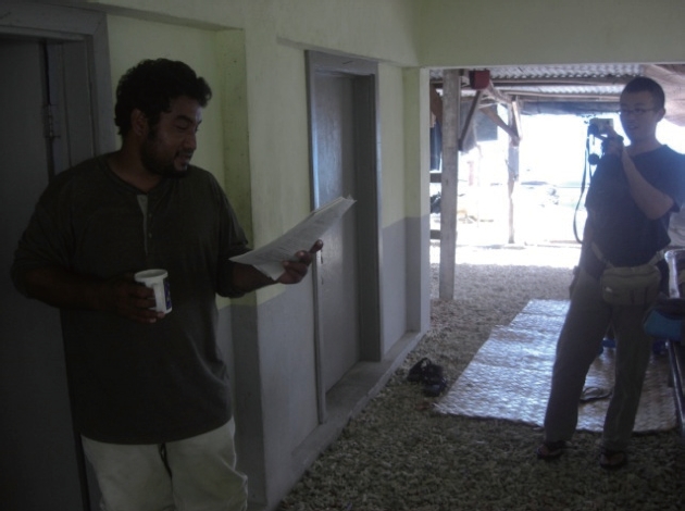
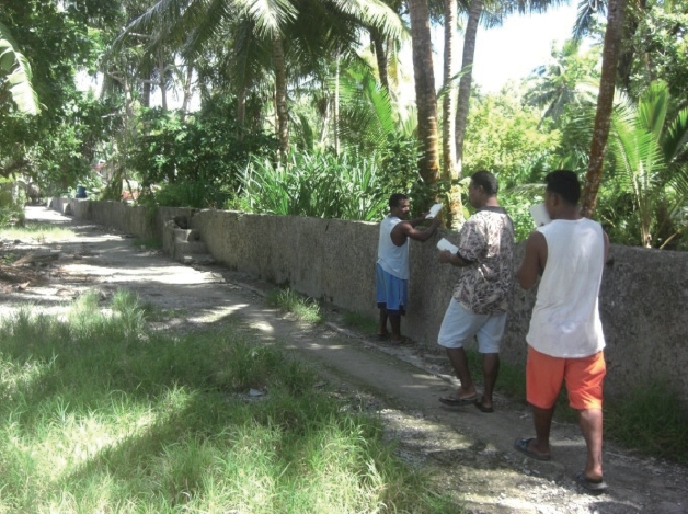
There used to be seawalls at Pingelap (Picture 1). They were constructed by the U.S. as aid to prevent disasters 30 years ago. Concrete was used in road boundaries. Despite being an outer island, there continues to be a higher rate of usage of the foreign-made and imported materials compared to the past. This can be said for the period beginning four and a half centuries ago. Rows of streets in the city were clean and felt very sanitary. Compared to previous literature reports, there is now a high level of sanitation, glorification, and a sense of social order and establishment. There was a feel of unified stability in the community as church is the community centre. There was some evidence of solar power devices being implemented, but it is at the second stage of dispersion (a stage that is post-introduction and the initial stage of spreading/prevalence). A rapid spread of solar power usage can be predicted in Pingelap as it demands high levels of energy to commute to and from the main island of Pohnpei. The exposure to the centre enhances acknowledgement of the lifestyle gap between the two regions.
This island was devoid of dogs. There weren't even any wild or pet dogs. This is to maintain the tranquil environment and poultry preservation. Moreover, this may shed some light on the underlying thoroughgoing social establishment. The conventional paramount chief Nahnmariki (an honorary title given to the descendents and kin of noble Nahnmariki and Naniken) has not resided on the island ever since evacuating from a major typhoon which hit the main island a century ago. Leaving the grievously devastated land, they have inhabited Sokehs Island, which was the primary migration site. The researchers met the nobleman at the village on Sokehs Island, and he showed lucid leadership and authority in the assembly.
On the other hand, Mokil atoll, which is closer to the main island, shows a fundamentally different social establishment. It eliminated the lineal aristocracy leadership over 50 years ago. Due in part to the eliminated aristocratic leadership, there is more evidence for developments in modernization, democracy, and equality compared to Pingelap and U village. No social class tensions were observed in the church congregation; instead, they were actively and equally cooperative in various activities. Many valuable observations were made by joining the church service and sharing a meal with the locals; furthermore, the day of our research coincided with the Regional Election Day which enriched the quality and the scope of the investigation. Japan has been more involved during initial stages of globalization and modernization in this area than during the pre-war period. The society has remembered the name of the architect who built the church. This is also true for the Okinawan who spread the technique of making smoked dried fish. This trade opened the opportunity for a monetary economy in this area. This product is appropriate for transportation by aircraft, and they have set regular customers on the main island of Pohnpei. For these reasons, there is a higher degree of penetration on Mokil atoll (e.g. monetary economy, better supply and resources, water sanitation and hygiene in houses, and solar power generators).
The production of crafts using local materials has been integrated into to the daily lives of the islanders. Their techniques are recognized as highly skilled and are respected. It has also signified a pluralistic barometer for individual personalities.
The high status and high occupancy of the public officials and the state government is impressive. There is high involvement in professions requiring higher education including officialdom, medicine, and education. This may corroborate the monetary economy, the support from the local groups, and acceptance in organizations after leaving the island. The prevalence of highly skilled professionals also may be explained by a weak social divide allowing for equal opportunities and individual responsibilities are encouraged which, in turn, has brought intrinsic motivation for personal development.
The industry considered to have a positive outlook in trading is pearl farming. It has even begun its operations. The leader in producing cultured pearls is a Japanese fishery graduate of this university who is currently residing in Pohnpei and working as a teaching staff at the College of Micronesia. He is incorporating the trade at Land Grant College.
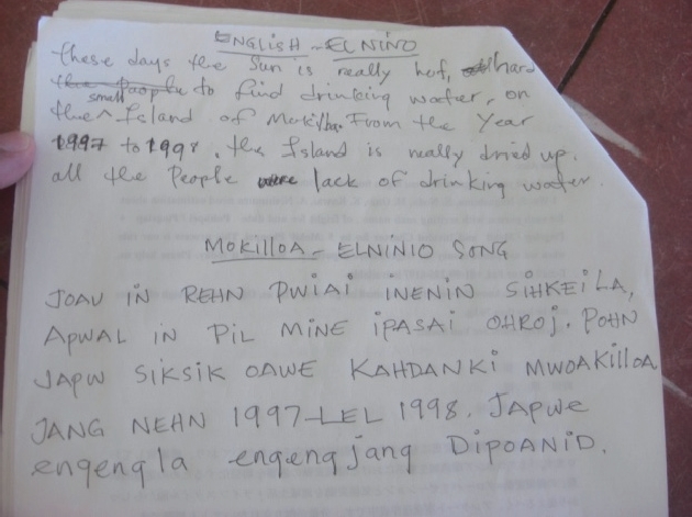
Another memorable observation was the El Nino song sung by the local children (Pictures 2 and 3). The lyrics have engrained memories of the heat, lack of water, aids received, and even the year of occurrences. For the adults, singing the song also brings out the detailed memories of the adversities at the time. The village on Sokehs Island has been an important community for evacuees from all islands. However, in 2010, the 100-year anniversary of the migration, Sokehs Island is forming a society with different lifestyles. Furthermore, for the reasons that it is close to the capital city and the centre of the state, there is large traffic of people crossing the border.
On the other hand, the traditional social order has been surviving in the U village, located on the outskirts of state capital Kolonia. Many current political and educational leaders live there despite having to commute for an average of an hour each day. There are marked developments in the monetary economy. There are more shops per set population, and even one medium sized company had its shop there. There is a cable television station located at the entrance of the village and, more over, DVD shops have taken over the VHS video shops.
The cooperation from the high school students has furthered the research. It was also advantageous in getting information about the lifestyle in the capital city. However, as questionnaires were targeted towards the head of each nuclear family, it was not used directly as comparative data. On the other hand, part of the questionnaires could be analyzed to compare the high school students, so our study would like to utilize this valuable quantitative information. It has a potential value for comparisons between the central regions such as states and countries.
>
Anxieties to the globalization and climate change impacts
The results of interviews and questionnaires on the islanders' anxieties regarding the globalization and climate change impacts conducted during house visits in each research fields are summarized in Table 3. They were conducted by all 5 research staff (cf. Yap 6 people). The analyses show that remote atoll islanders were more anxious about the climate changes than islanders living on the island. Each community showed different patterns of emphasis on social anxiety.
The investigation conducted in 2008 focused on two outer islands off Yap Proper and the coastal village on the main island. Unfortunately, there was a lack of cooperation from the high schools and, consequently, high school surveys were not conducted. Subsequently, it was possible to conduct comprehensive field research (environmental evaluation) on each region as well as manage questionnaires and interviews. This extensive investigation covered regional differences in the change in the socio-economic cultural system, impacts on the natural environment, and community spirit. This was quantified into individual and comprehensive components (e.g. environmental evaluation on separate atoll regions and the whole regions, concerns and stress of the residents, lifestyles). Some region-specific differences were observed when the components were evaluated as a whole. The data collected has enabled diverse analysis.
[Table 3.] The degree of the villagers’ anxiety ? Pohnpei
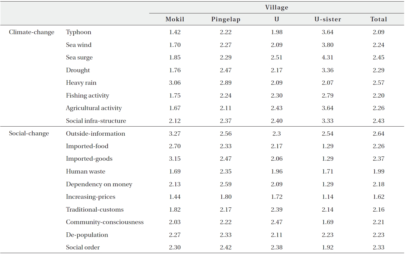
The degree of the villagers’ anxiety ? Pohnpei
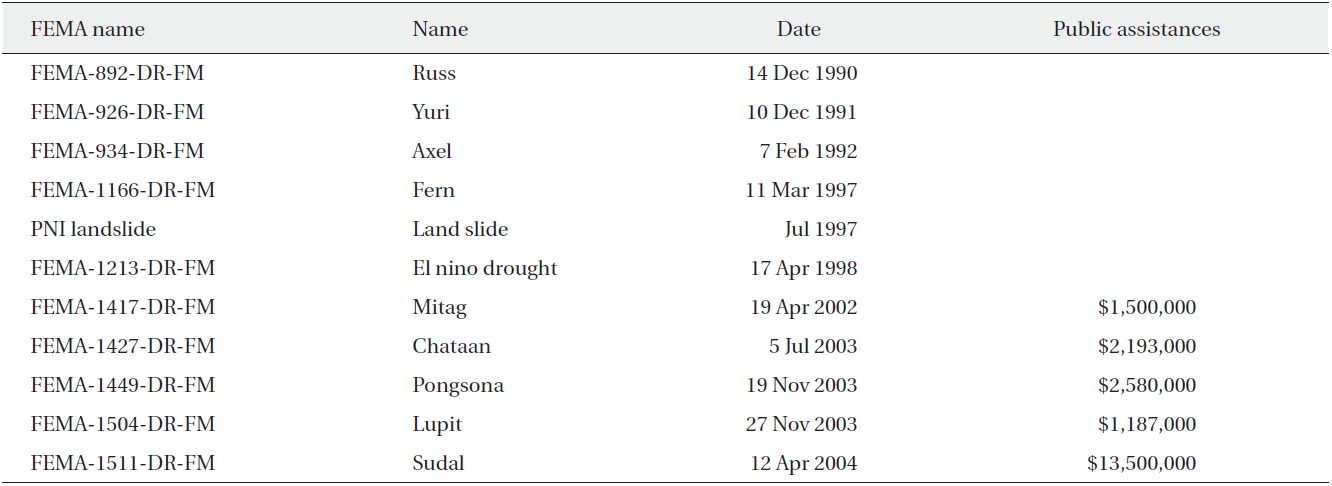
[Table 4.] Federal Emergency Management Agency (FEMA) expenditures

Federal Emergency Management Agency (FEMA) expenditures
The largest impact on this region recently was the direct outcome of Typhoon Sudal and of the massive foreign aid relief the devastation has brought to the land. The social impacts, especially by the extensive federal aid for Yap and the disaster recovery team, have brought a drastic change to the whole society and livelihood structures. This typhoon hit Yap Proper and the Outer Islands in April 2004. There was extensive direct damage to the infrastructures such as roads, bays, harbors, and buildings. Indirect damages also affected the population such as the decline in sanitation.
The east coast suffered from taro patch damages, and its recovery was reliant on paid manual work. There was a benefit to this despite the expense. The areas previously suffering from managerial neglect have received some attention for work and recovery. Rather, under the circumstances, this may give light to oversee appropriate land usage from the managerial perspective. The southern coast line of the village of Gachpar on Yap Proper also suffered from taro patch damages, but has been used despite the damages. There was a crown of thorns starfish outbreak from the sea in Eastern Bay and annihilation from the south. The local diving authority noted these early changes as well as comparable blotched damages (when the sea is stirred by typhoon, it is known to cause the opposite effect of the El Nino whitening phenomenon; on a different note, the causal relationship between crowns of thorns starfish and typhoons is extremely interesting and must be considered for future research).
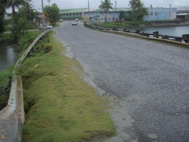
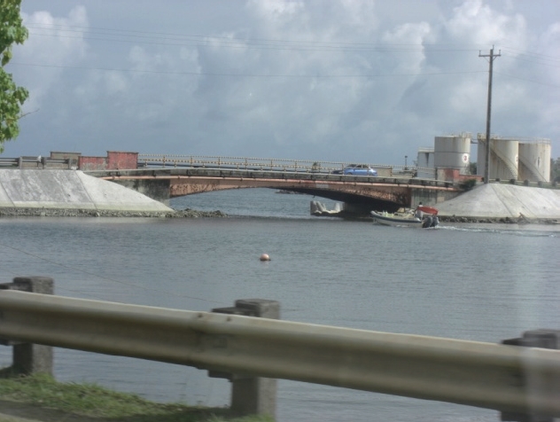
The FSM received vast foreign aid recovery fund, especially from the U.S. Department of Homeland Security's (DHS) Federal Emergency Management Agency (FEMA) (Table 4). The usages in cars and mobile phones have increased drastically, and there have been significant changes in roads, harbor, and community facilities. This enormous external aid and its trails of globalization along with climate change have transformed aspects of Yap Proper society.
A typhoon with catastrophic devastation occurs at a rate of one in a century. The total sum of the recovery fund reached at the initial stage was 2.2 billion yen. It is believed that 0.8 billion yen was contributed by various private sectors. Most of the rescue fund went to Yap Proper. The population of the State of Yap is 14,000 (of which 9,200 live in Yap Proper). If all the money was to be invested on the main island, then aid would calculate to 239,000 yen per person. Similarly, the allotment would be 87,000 yen per person if all the funding came from the private sector. If the private sector was to pay per household, then that would total up to 566,000 yen per household. Japan contributed lots of money as well, but the local impact remained big. Undeniably not everyone was a direct victim, but every resident was affected in one way or another.
The car usage bumped up three-fold in the initial stage of the recovery, and concurrently a building development surge.
The pictures above (Pictures 4 and 5) are of the same location. Within a year and a half, a rapid recovery in city functionalities can be already seen.
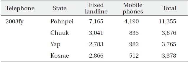
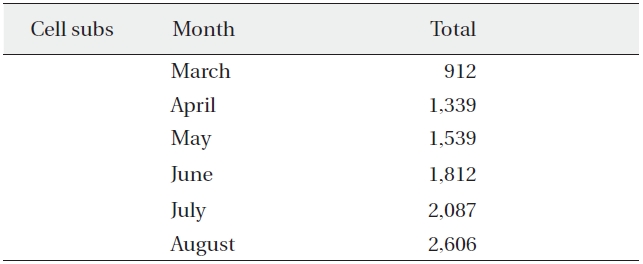
The symbol of the information age by many, mobile phones have started spreading in 2003. There has been latent demand increasing cash flow with the demand inflating explosively over the months (see below Table 5) (The C.E.O. of FSM Telecom, a Japanese descendent, has kindly supplied the information). There was 2.7 fold increase 6 months post-typhoon as compared to pre-typhoon.
The yearly growth from the end of 2003 until the end of 2004 was 1.6-fold in Pohnpei, 2.7-fold in Chuuk, 2.8-fold in Yap, and 1.8-fold in Kosrae. The growth rate is high like Chuuk, but the accelerated 6-months growth was the result of the Sudal recovery fund (Table 6). The sharp rise was especially prominent for the months directly following the typhoon: April, May, and June.
The growth has been maintained after the development and economic principles have been at work. Looking at Yap from the end of 2004 through 2007, mobile phone usage increased by 1.4 % with the landline usage decreasing by 13%. Similarly, Pohnpei mobile use increased by 1.3% while landline decreased by 16%. Chuuk's mobile use increased by 2.3% while landline usage decreased by 38% (Table 7). In Kosrae, mobile usage increased by 1.8% while landline use decreased by 14%. The wave of information indicated by mobile usage is growth towards saturation and exists at a constant rate even though there is a gap in the time compared to the capital island. The rest were instigated by the economic principle of landline saving. This case in Yap is a representative and illustrative short term intensive spread triggered by external factors.
[Table 5.] The prevalence of telecommunication by state in 2003

The prevalence of telecommunication by state in 2003
[Table 6.] Yap Cell Subs before and after Typhoon Sudal in April, 2004

Yap Cell Subs before and after Typhoon Sudal in April, 2004
[Table 7.] The prevalence of telecommunications for years 2004-2007
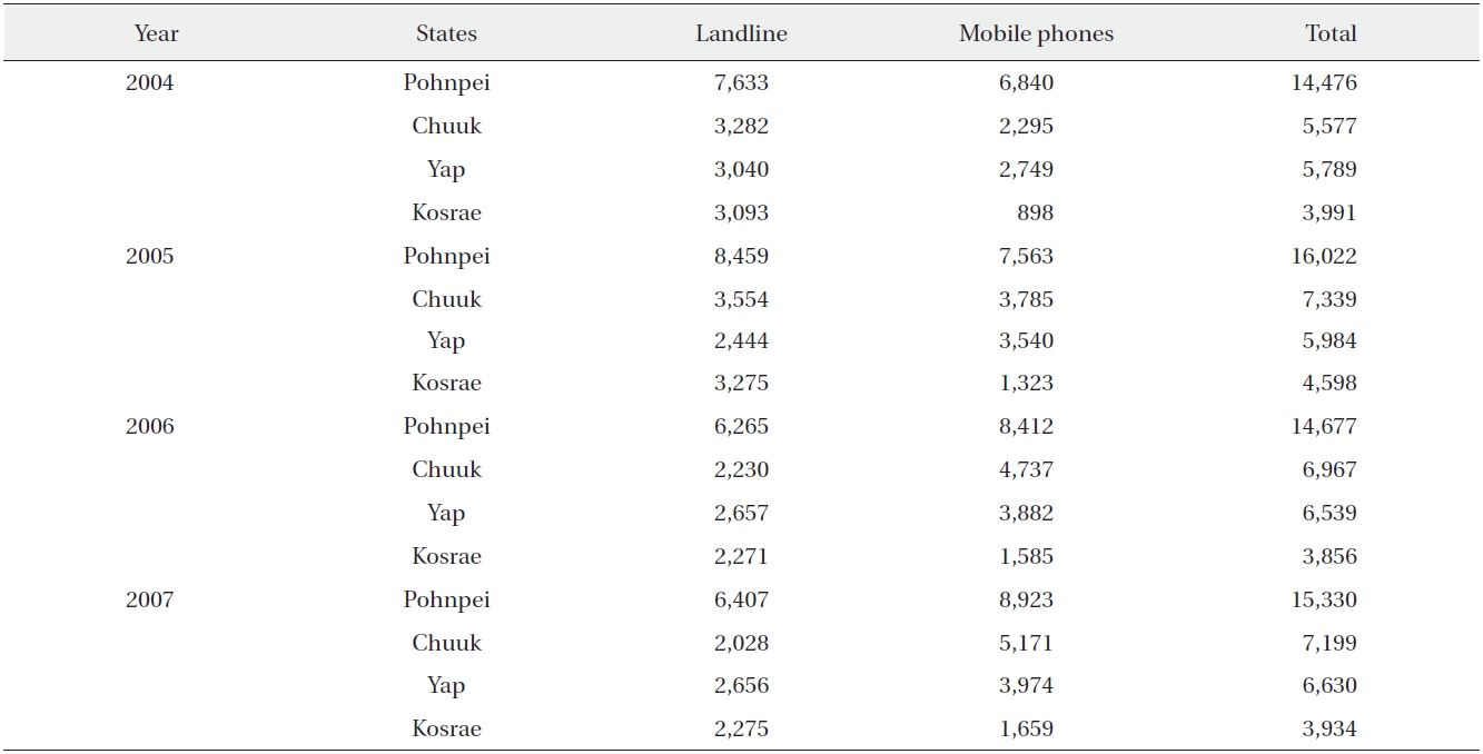
The prevalence of telecommunications for years 2004-2007
Steel framework pylons and experimental installations for mobile phone services have been built on Falalop in neighbouring Ulithi atoll. This venture was implemented due to its advantageous locality, an island with aircrafts, and it would be possible for technical support and customer services including manufacturing faults can be dealt with immediately. Cellular-subs were 78 at Ulithi on 6 July 2007. However, at the time of the research, it was not in use and even the internet access had been halted. The highest need/demand user is the Outer Islands High School. In reality, these are not an uncommon state of affairs on an outer island.
Unlike Yap Proper, the recovery aid in Ulithi was secondary and came with delay. Perhaps a contributing factor to this is the fact that it was not seen as a priority in comparison to the capitals as it has no capital function. However, the reason behind 'being abandoned' was not the conventional main island vs. outer island. Conventionally, the parent village would become temporarily involved in the life support and recovery after devastations. In other words, this may be comparable to being normalized or even a result of globalization as a phenomenon.
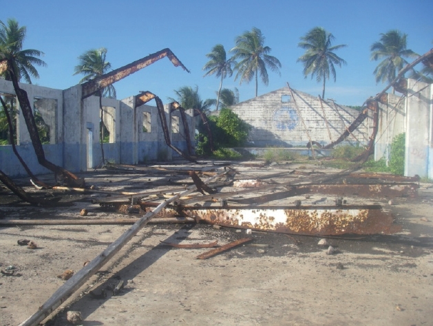
A demonstrative example is the neglected gymnasium of the Outer Island High School (Picture 6), left abandoned with the debris from the wreckage without a roof. Information technology (IT) was dependent upon aid from the country and other investors, but help could not reach to that extent.
The Outer Islands, Falalop Island of Ulithi atoll and neighboring island Fais, were in a state of crisis for four months because the foreign freighter carrying rescue goods broke down. Results included the tripling in price of imported rice, stores suffered from stock shortages, and day-to-day expenses and fuels that are especially reliant on delivery from the outside were in critical condition. Eventually stores ran out of stock and only the overpriced rice was left. High dependence on traditional food (e.g. tubers, lagoon fish, citrus juice, citrus shoot extract) was seen once again.
[Table 8.] The degree of the villager’s anxiety - Yap

The degree of the villager’s anxiety - Yap
The island's precious source of cash income comes from tobacco, fabrics made from banana fibers, waistcloth, and betel nut trees. Although they have not yet reached the societal resurgence where sustainable subsistence is possible, a small amount of progress was observed. Despite the ongoing concerns for societal reform and transformations sparked by climate change, the impact by the latter is a more significant issue to the locals.
In terms of foundation of life on Fais, elements of outer island remoteness are still observable within its traditional society. Although neighboring some illustrative examples include regional caste system with chief being the prime being and there are customs relating to production such as taro patch management in matrimonial relation and tributes to the family of the bride. However, there is a wave towards a monetary economy in terms of livelihood and production and there is a high need for cash to support daily living - from tobacco production (to Yap Proper) to handicrafts (e.g. weavings made by a group of women working in a thatched hut without walls, to bring in cash mainly from tourists). These small trades that bring in cash provide payment for transportation to and from Yap's capital via aircraft, education for children, support the influential lifestyles the migrants bring in, and so forth. This further creates a demand for cash. The people are becoming more reliant on "money" and, therefore, are forming stronger attachments to it.
Historically, there was a phosphorous mine on this island. There were traces of an abandoned Japanese village left over from pre-war phosphorus mining, unworkable agricultural land ruined due to the digging, and abandoned factory and shipping remains. These relinquished remains are the result of modernization process brought from the outside. There is a definite, although minute, production and structural transformation on this island, but it can be assumed that the lifestyle based on low (if not restrained) consumption is in a preparatory stage for latent reformation.
Coastal and lowland villages are more anxious about climate change, and the traditional dignified mainland community has more concerns regarding globalized social change (Table 8).
FOR FUTURE RESEARCH STUDIES AND INTEGRATION
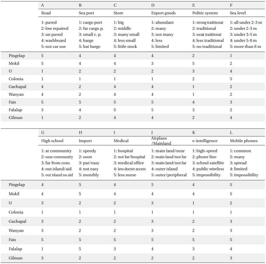
Although the research was conducted in a small populated region, it was possible to obtain the numbers necessary for quantitative research in each research field. In addition to this, it was possible to obtain information about each research region - the marine environment and the evaluation of fishery activities; terrain plants and the evaluation of agricultural activities; livelihood and culture and the comparative evaluation of mental health in everyday life; sanitation and the evaluation of medical environment; regional commercial activities and the assessment of consumer livelihood and environment; regional infrastructure, industrial and manufacturing establishments, and the evaluation of information sources. The connection to the outside world has been strongly enhancing regional characteristics. This was contributed by the (in)convenient and (un)reliable transport and dispatch systems, the relationship with local emigrants, the experience of powerful environmental damages, the frequency of contacts with the outside media culture, the support from the leadership of NGOs and the central government, and the participation and involvement in the socio-political structure.
Numerous quantitative analyses were possible, and it was also possible to run comparisons on the regional basis. Based on the exploration into individual contents and the multitudes of analyses conducted, area-specific biases were seen. Concerns shown by the members of the society such as globalization impact and environmental change may seem one and the same, but they have definite boundaries. The prominent concerns for climate change may be reversed in certain regions (such as the abnormalities in Mokil). Also, even in the midst of the anxiety, closeness in terms of distance somehow deviated the two groups from both concerns. However, that it is questionable from the clusters of analysis that phenomena can be seen as being connected. The details of the data and their analyzed results are expansive and complicated and, are therefore, omitted from this paper. There are many items that need discussing in detail (e.g. living and health awareness, concerns and various attributes and qualities; the subjects and educational contents or curriculum that are deemed important by the people; each person's awareness of self, health, identifying concerns, their relationships, and demographics). However, the finale calls for the full use of data in the light of individual contexts and backgrounds. Table 9 is a sample index of the background structure of the community.
There was some qualitative evaluation of regional data that was transformed into quantifiable figures. These especially relate to quantifying each regional living and environmental characteristics. The value of the data would increase in significance when data from unexplored regions are added to the already-investigated regions in this (Pohnpei and Yap) and previous (Chuuk) field seasons; the list includes Kosrae (Nagashima 2010), Marshall Islands, Palau, Kiribati, Nauru, Northern Marianas, and Guam. However the data attained from the outer islands are not enough. As these measures become bigger and more cumulative, they can be compiled and integrated into overall comprehensive social statistics. This will further valuable analyses. Therefore, continued research is required to prepare for enriched and superior investigation.
[Table 9.] The classification index of the community structure

The classification index of the community structure