The equilibrium theory of island biogeography (MacArthur and Wilson 1967) is predicated on the assumption that the size of an island and its proximity to the mainland determine the species richness on an island, with larger islands and those nearer the mainland harboring more species than the smaller or more distant islands (Whittaker and Fernandez-Palacios 2007). The theory has been applied as a fundamental principle in many ecological studies, but the landscape pattern matrix related to the islands has been investigated only in studies of species abundance, even though the landscape structure of island composition is one of the most important factors affecting species abundance and distribution (O’Neill 1988, Forman 1995, Haila 2002, Lawler and Edwards 2002, Hong et al. 2008). Large-scale development projects and recreational activities along the coastal areas have altered the landscape composition and spatial arrangement of each land-cover type in island landscapes, resulting in variations in species richness. The landscape index has been evaluated to determine species richness on uninhabited islands, with the advent of novel landscape ecological approaches and remote sensing technologies (Kohn and Walsh 1994, Hong et al. 2008).
Several studies have assessed the impact of a variety of island characteristics on species diversity under different geographical conditions (Kohn and Walsh 1994, Chung and Hong 2002, Choi 2004), geomorphological characteristics (Chung et al. 2008), and human disturbances (Hong et al. 2008, Kang 2008). These previous studies have focused on the species occurrence and abundance of vascular plants and butterflies to the exclusion of their spatial arrangements of neighboring islands. Kang (2008) previously evaluated the geographical distribution of avian communities on islands with environmental conditions including the areas of the islands and their distances to the mainland. Recently, several studies of island ecology (Choi 2004, Oh and Beon 2007, Song et al. 2009) have evaluated the spatial distribution of vascular plants and their relationships with the characteristics of the islands. Whereas many studies have evaluated the impacts of geographical characteristics on species richness, island studies have rarely been conducted regarding the impact of landscape pattern matrices on the subsequent species richness of vertebrate animals (i.e., birds). Spatial attributes (patch density, mean patch size, distance to nearest neighbor, mean shape index) may allow for more explicit descriptions of an ecological system than geographical contexts alone; the similar size of uninhabited islands can be estimated to have differing effects on species richness, owing to the dominant habitat type of the islands and the characteristics of their neighboring landscapes.
The principal objectives of this study were to characterize the relationships between the geographical conditions (e.g., distance to the mainland, island area) and landscape patterns around the uninhabited islands, and to evaluate the effects of the landscape structures on species richness, which have implications with regard to the management of islands and landscapes. Additionally, this paper describes some of the limitations of the equilibrium theory of island biogeography. Geographical information system (GIS) techniques are utilized to analyze the spatial patterns of landscape elements at a landscape scale to determine whether or not there are differences between habitat type compositions along the distance to mainland and protected island areas.
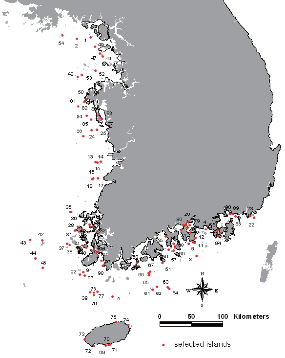
The dataset utilized in this study consisted of species data and environmental data for 100 randomly selected uninhabited islands and their surrounding landscapes (Fig. 1). The species data of each island included the presence/absence and number of species of vertebrate animals (i.e., birds). This study addressed only bird species, because birds both on and near the islands are affected, but the comparisons of the bird species and landscape patterns near the islands remain poorly understood. These species data were created from the first nationwide survey on natural environments for 651 uninhabited islands, which were based on fieldwork by scientists and local experts from 1998 to 2002. The species richness of each island was calculated by counting the numbers of bird species observed per island.
The environmental landscape data provides the geographical conditions, island characteristics (i.e., size and shape), and landscape pattern of each island. Data regarding geographical conditions and the sizes of islands were derived from the topographic maps (1:25,000). Shoreline data were obtained from the Landsat ETM images, and the protected areas were developed by scanning and manually digitizing the legally protected area documents, which were paper maps based on topographic maps, and were used to estimate the effects of the distance to mainland and protected area on species richness. Protected areas, in this study, include ‘Wetland Protection Areas’, ‘Ecologically and Aesthetically ImportantAreas’, ‘Designated Islands’, ‘Wildlife Protection Areas’,‘National Parks’, ‘Maritime Environmental ConservationAreas’, and ‘Monument Protection Areas’.
In order to identify the landscape pattern neighboring the islands, landscapes of 5,000 m-buffered areas from the boundary were delineated for the selected island surroundings. The land cover maps of seven classes were obtained to determine the extent of the landscape of each island. Twenty three classes of the land cover maps were reclassified into an aggregated classification scheme of seven classes: woody, herbaceous, bare-ground, wetland, cropland, open water, and urbanized areas. These aggregated land cover maps were utilized to quantify the landscape structure, as well as the topographic maps and satellite images, to estimate the distance to the mainland and the area of each island.
Species richness data were developed for each island, and have been correlated with environmental data to assess the effects of the distance to mainland and protected areas on the species richness. The Spatial Analyst Extension for ArcView GIS program was employed to calculate the mean distance to the mainland of each island (Environmental Systems Research Institute 1998). The environmental attributes of the islands consisted of the island area, distance to the mainland, and habitat type.
Nationwide land cover data were obtained and used in the development of landscape maps, and the data were reclassified into species richness-related patch types. The land cover categories of each island were converted to raster format with a pixel size of 5 m using the Spatial Analyst extension. The landscape characteristics were then analyzed on seven class levels (woody class, herbaceous class, bare ground class, wetland class, cropland class, urbanized area class, and water class) and landscape level using the ArcView Patch Analyst extension (Elkie et al. 1999) developed using the FRAGSTATS landscape analysis software (McGarigal and Marks 1995).
A wide variety of landscape indices have been developed to quantify the landscape patterns of individual patches, patch type classes, or of entire landscapes (Forman 1995, Hong et al. 2008). The redundancy and overlap among landscape indices have been previously evaluated (O’Neill et al. 1999, Li and Wu 2004). Not all of the landscape indices were acquired in the assessments of each land-cover composition and spatial configuration of the landscape. A small sub-set of the landscape indices were selected to identify the landscape patterns, which evidenced ecologically reliable and statistically significant factors. Some have argued for the desirability of indices that combine multiple pattern components into a single value to reduce the number of variables carried in a multivariate analysis (Riitters et al. 1996). Others have asserted that it is difficult enough to interpret indices that measure a single component of spatial pattern, and that any method to quantify spatial patterns must be examined and assessed under controlled conditions (Li and Reynolds 1995). One solution that has been proposed involves describing fundamental and independent components, and developing a suite of indices by which those components might be measured.
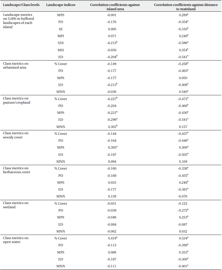
In order to identify the relationships between the species richness and landscape pattern of each island, seven landscape pattern indices at the landscape level were selected for the quantification of the landscape patterns of uninhabited islands; these indices were the mean patch size (MPS), patch density (PD), interspersion and juxtaposition index (IJI), mean proximity index (MPI), Shannon’s diversity index (SDI), mean shape index (MSI), and edge density (ED). A patch represents an area that is covered by one single habitat type. In this study, each patch was delineated with the land cover type of satellite imagery. MPS and PD are direct information regarding the landscape pattern, PD expresses the number of patches within the entire landscape, and MPS is the average size of patches in the landscape. The value of IJI, a measure of the spatial configuration of patch types, increased as the patches tended to be more evenly interspersed in a “salt and pepper” mixture (McGarigal and Marks 1995). MPI considers the size and proximity of all patches whose edges fall within a specified search radius of the focal patch. The index quantifies the spatial context of a habitat patch in relation to its neighbors of the same class. SDI quantifies the diversity of the habitat type: the number of different land cover types and the proportional area distribution among patch types. The index is calculated by adding for each patch type present the proportion of area covered, multiplied by that proportion expressed as a natural logarithm. MSI is a measure of the deviation of a patch shape from that with the lowest possible perimeter- area ratio. When working with raster (grid) data, a square is the simplest possible shape, and has an index value of 1. A high shape index indicates a patch with a perimeter-area ratio substantially higher than that of a square, hence possessing a complex and/or convoluted shape. ED is the total linear distance of the edge measured for all patches divided by the landscape area, ex-pressed as meters of edge per hectare (Forman 1995). At the class level, the spatial patterns for land cover, includingwoody class, were quantified via 5 landscape metrics: percent cover, PD (number of patches/ha), MPS (m2), ED (m/ha), and mean nearest neighbor distance (m). In this study, habitat patch was defined as an area of continuousland cover type. The nearest neighbor distance is the shortest edge-to-edge distance measured between a givenpatch and the nearest neighboring patch of the same patch type (i.e., woody to woody).
In order to identify the relationship among distance to mainland from island, island area, and protected area, correlation analysis was conducted using SPSS (SPSS Inc., Chicago, IL, USA). Descriptive statistics were calculated and utilized to allow for the comparison of the distribution with the distance to mainland and landscape pattern indices, and also to identify landscape differences between protected areas and other areas. The landscape pattern indices were characterized by the mean within-landscape indices for the island.
The ArcView map algorithm function was employed to calculate the distance to mainland from the island and area of island, based on high-resolution satellite images and topographic maps. Different aspects of uninhabited islands are explained by designating protected areas, as well as the distance to mainland and the island area. Despite different impacts of distance to mainland and the area of island on species richness, correlation analysis was conducted to test for relationships between species richness and landscape pattern indices. Stepwise regression analysis was employed to evaluate the effects of the landscape pattern indices and geographical conditions on bird species richness (Green et al. 1996).
>
Descriptive statistics of selected islands
The sampled islands are evenly distributed at a spacing of 5,000 m to 30,000 m, and the number of islands are proportionally consistent with the administrative boundary; that is, 41 islands in Jeonnam Province (Goheung, Haenam, Jindo, Shinan, Wando, Yeosu), 19 islands in Gyeongnam Province (Geoje, Goseong, Hadong, Jinhae, Namhae, Sacheon, Tongyoung), 12 islands in Jeju Province (Bukjeju, Namjeju, Seoguipo), 11 islands in Chungnam Province (Boryung, Taean), 9 islands in Incheon Province (Ganghwa, Ongjin), 6 islands in Jeonbuk Province (Kunsan, Buan), and 2 islands in Pusan Province. Average distance to mainland was 11,263 m from the selected islands, ranging from a minimum of 98 m in Hak-do, Hadong county, Gyeongnam Province to a maximum of 71,988 m in Top-seom, Shinan county, Jeonnam Province.
In the 100 selected islands, 60 islands are legally protected for the conservation of ecosystems and natural resources by the central government, including the Ministry of Environment. Average size of uninhabited islands, in this study, is higher in non-protected areas than protected areas. The mean island size value was 212,482 m2 for the non-protected islands, but 122,828 m2 for the protected areas. The area of island and coastline were highly positively correlated for both protected and non-protected areas. The results of Pearson’s correlation showed that the coefficient of island area and coastline was 0.842 (
According to the correlation analysis between the distance to mainland and protected islands, protected islands were shown generally to be located far from the coastline, relative to the non-protected islands. The mean distance to the mainland is 12,174 m in the protected islands, and 9,896 m for the non-protected islands. Species richness, as represented by the number of bird species recorded for each island, was found to be far higher among the protected islands than the non-protected islands. The average number of bird species was 6.18 for the protected islands and 5.70 for the non-protected islands, thus suggesting that bird species are more abundant in protected islands, which tend to be located far from the mainland, with small-sized uninhabited islands.
>
Landscape pattern indices of uninhabited is-lands and neighboring landscapes
Landscape composition - the proportion of total area occupied by each land cover type - of the sample islands and their landscapes differed slightly based on assessments using the 100 randomly-selected islands and 5,000 m buffered areas of each island. The average number of land cover type was 3.9 within the islands, and was increased to 6.4 in the neighboring landscape. Woody and herbaceous covers were found to be distributed widely across the selected islands. Seventy seven islands had woody cover of an average size of 114,814 m2, followed by herbaceous cover of an average size of 33,156 m2 on 69 islands. By way of contrast, cropland cover comprised a small proportion of the landscape and was sparsely distributed only over 21 of the selected islands. In the neighboring landscape, the proportion of open water is most abundant with a less dense arrangement of large, continuous patches. However, woody and herbaceous patches were found to be distributed sparsely across the landscape, in many small patches.

Correlation between landscape pattern indices of the 5,000 m buffered area centered on selected islands both at the landscape and class levels against island characteristics (island area, distance to mainland)
Landscape pattern indices were calculated for both landscape and class level, and the indices were correlated significantly with the geographical contexts of the selected islands, including island size and distance to mainland (Table 1). All the indices were statistically significant and closely correlated with the distance to mainland, except for ED in the urbanized area, and the mean nearest neighbor distance in cropland, woody, herbaceous, and wetland classes. With regard to the size of islands, however, only SDI and ED were statistically significantly correlated at the landscape level. A few landscape variables of wetland, herbaceous, and woody classes are related significantly to the size of the islands. In the case of cropland class, percent cover, mean patch size, edge density, and mean nearest neighbor distance were correlated with island size.
Table 2 shows differences in the landscape pattern indices at the landscape level between the protected and non-protected areas. Landscape pattern indices, including patch density, mean shape index, and ED did not differ significantly between the protected and non-protected islands at the landscape level. However, the MPS in the non-protected areas was 439.8 m2, which is greater than the 196.1 m2 measured in the protected areas. The proximity indices are higher in the protected areas, thereby indicating that more patches of same patch type are located in a neighborhood in which the corresponding patch type is distributed in larger, more contiguous, and/or closer patches than other patches in protected areas.
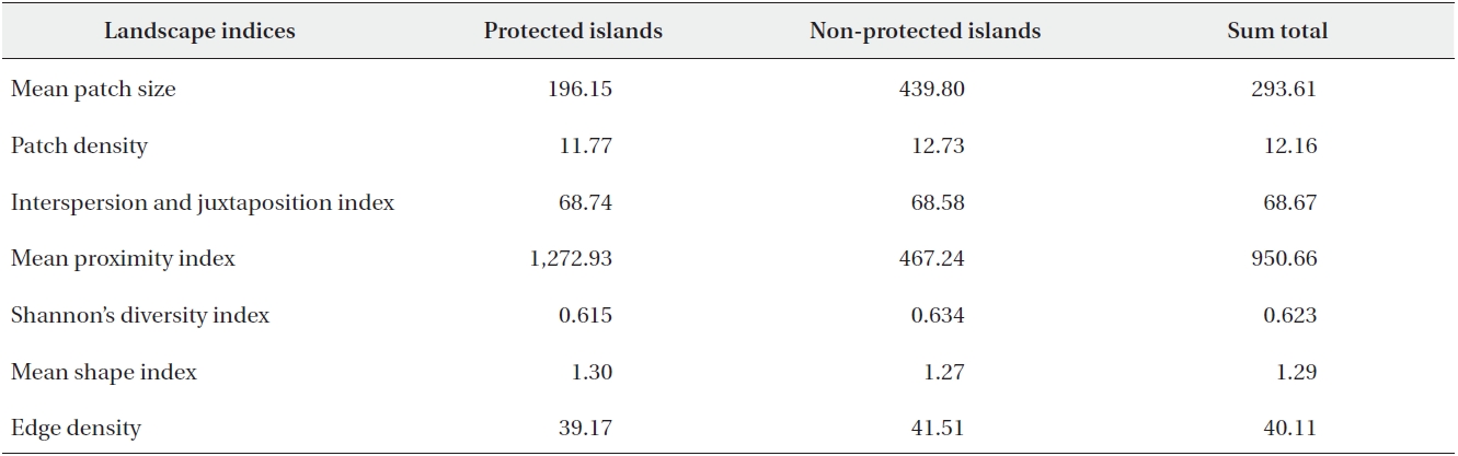
Mean values of landscape pattern indices at the landscape level between protected islands and non-protected islands
>
Species richness related to landscape pattern indices
In deciding which geographical conditions and/or landscape characteristics more profoundly affect species richness on uninhabited islands, three types of regression analysis were conducted. First, stepwise regressions for geographical conditions against species richness were developed with island area and distance to mainland. The results demonstrated that island area was correlated positively with bird species richness, but distance to mainland was not a statistically significant factor. Regression results for bird species richness explained 12.5% of the total variance. The next step was to evaluate the effects of landscape characteristics on species richness. The regression analyses on landscape pattern metrics for species richness differed between landscape level and class level. As can be observed in Table 3, the regression models at the class level explained 31.8% of the total variance, but the landscape level model explained 6.8%.
For the landscape pattern metrics associated with species richness, % cover, patch density, and ED at the cropland/pasture, woody area, herbaceous area, and water classes were applied to our regression analyses. Percent cover and PD of the cropland/pasture were statistically significant and correlated positively with species richness. The majority of landscape indices for woody, herbaceous, and water classes were non-significant in regard to bird species richness, with the exception of ED of woody and water classes. Landscape pattern indices at the landscape level were not statistically significant in regression analysis, but SDI was correlated positively with species richness.
The results of this study demonstrated that geographical conditions and landscape structures of uninhabited islands can be quantified using a combination of landscape pattern indices and spatial analysis. Currently, many scientists and natural resource managers have become convinced that wildlife species are governed by spatial arrangements of habitat types (Lawler and Edwards 2002, Hong et al. 2008). Island ecology has long been conducted for assessments of species richness associated with environmental gradients (Haila 2002, Whittaker and Fernandez-Palacios 2007, Kang 2008). Traditionally, the island area and distance to mainland have been selected as the principal factors affecting species richness, but landscape ecologists continue to add the effects of landscape configuration on species richness (Heaney 1984, Panitsa et al. 2006, Kim and Hong, 2009). This study demonstrated that landscape pattern indices at the class level more explained the variances in species richness than the geographical conditions and the landscape pattern indices at the landscape level (Table 3).
Although geographic factors were less profoundly correlated with species richness than landscape pattern indices, in this study, island area and distance to mainland were still significant in terms of understanding bird species richness (Chung and Hong 2006). Moreover, the combined effect of landscape characteristics and geographical conditions was superior to the effects of landscape alone in explaining species richness (Panitsa et al. 2006). Island area is positively correlated with the bird species, and distance to mainland is negatively correlated, indicating that large patches near the mainland might be a good place to observe more bird species. These observations support suggestions made by Dennis et al. (2000) on butterfly diversity. They suggested that more butterflies inhabited large islands near the shoreline, possibly caused by the fact that relict butterflies may have become extinct except on a few larger islands, and colonization from the mainland is easier near the coastline.
It was clear, though not surprising, from the results of this study that the degree of landscape pattern indices was dependent on the distance from the island to the mainland. Specifically, all landscape indices were correlated closely with the distance to the mainland. Whereas the landscape level indices allowed for the characterization of the spatial arrangements of land cover, class level indices provided more detailed information regarding the relative contributions of individual patch types (O,Neill et al. 1988, Li and Wu 2004). Landscape composition and landscape configuration may have considerable effects on habitat quality and movement routes (Franklin and Steadman 1991), and are therefore useful in the establishment of environmental management plans for bird species and to designate protected islands. In addition to differences in the abundance of bird species, the spatial arrangement of landscape patterns in geographical contexts has some direct implications for environmental management, as reflected by the abundance and spatial pattern of the habitat type. The distribution of woody, herbaceous cover and the distance from islands to the nearest mainland may affect the habitat suitability of bird species, as well as the accessibility of desired food resources to wildlife species. Landscape patterns, specifically patch density, size, and spatial arrangements affect the movement and habitat quality of birds.
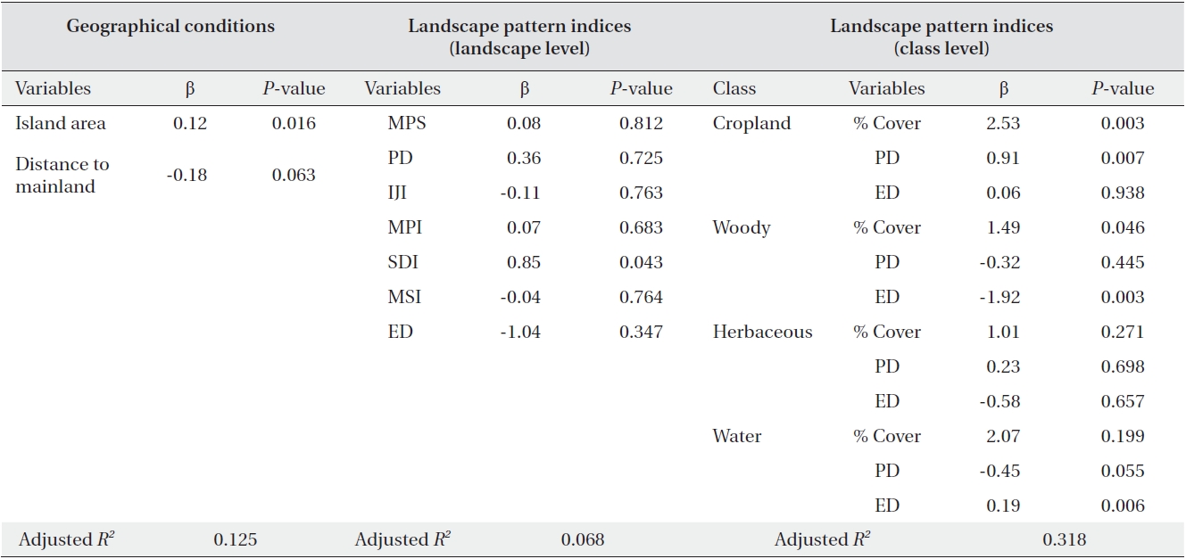
Regression analysis on the effects of geographical conditions, landscape pattern indices at the landscape and class levels on bird species richnessof the 5,000 m buffered area from the selected islands
The coincidence of landscape patterns along geographical conditions such as distance to the mainland were confirmed via correlation analysis (Table 1). The distance to the mainland and landscape pattern indices were closely correlated. The number of landscape indices both at the landscape and class levels is largely influenced by geographical contexts, specifically the distance of islands from their mainlands. Distance tends to dominate island dimensions in accounting for the incidence of species that could be analyzed. The distance of islands from the mainland largely account for differences in species numbers through differential migration capacity, and is directly relevant to species transfer in ecological time. Geographical elements alone influence the number of species via colonization potential and persistence (MacArthur and Wilson 1967, Choi 2000, Chung and Hong 2002); as such, the elements of both landscape configuration and the habitat type of each island affect species richness.
It is crucial to understand how landscape structures affect foraging and hiding birds. Birds can move readily from place to place to locate new resources and suitable conditions, and are not restricted to one place (with the exception of nesting birds). Therefore, the landscape structures of different habitat types around islands are assumed to be important factors affecting bird species richness. The area of an island is positively correlated with its species richness, and the distance to the mainland is statistically significant in terms of describing species richness. Although the area of island is related closely with the number of plant species (Heaney 1984, Choi 2004), distance to the mainland is a relatively poor predictor of the number of plant species. However, birds require a relatively large territory to live, and also require a greater variety of habitat types than do plants (Ding et al. 2006). The mainland, which is usually composed of different habitat types, is a major source of different bird species, and thus the number of birds will increase with decreasing distance to the mainland from an island.
The results of spatial analysis support observations of a broader area of islands to evaluate species richness, as compared to analyses of uninhabited islands alone. Many scientists have discussed the ecological importance of neighboring islands and inter-island configurations in species diversity through observation (Dennis et al. 2000, Chung and Hong 2006). These landscape analyses likely contributed to our understanding of ecological processes and species structures, due to the effects of neighboring patches and landscape connectivity, functioning as wildlife movements through single islands to other nearby islands and the mainland (Kim and Hong 2009). Spatial patterns of landscape patches have not yet been sufficiently widely considered in the island management literature, which has focused principally on the designation of protected islands (Seo 2004, Nam and Kang 2005). Differing spatial patterns and patch attributes following the designation of protected islands may exert critical impacts on current ecological processes as well as future characteristics of island ecosystems, and consideration of spatial patterns should be a part of designating island management plans. Species richness, particularly the species richness of bird, has long been studied to determine the effects of human activities and resource management strategies for ecosystem integrity. Bird species generally require relatively large and diverse habitat types, and thus bird species are frequently employed in evaluations of the habitat suitability of physical environmental and landscape characteristics (Kang 2008). In general, environmental factors that attract bird species are facilitated by the provision of sufficient food resources and tolerance conditions (Ding et al. 2006). Cropland/pasture is a great source of food during the growing and wintering seasons, and thus many migratory birds use the islands near cropland/pasture and herbaceous areas. Cropland also helps to conserve cultural landscapes for attracting tourists (Hakim et al. 2009). The regression results of significant correlation between cropland class landscape indices and bird species richness, as described in this paper, indicate that food resources near the islands are critical elements of bird species richness, thereby indicating that natural resource managers should maintain cropland/pasture and herbaceous covers for bird habitats.
The changes in landscape pattern indices related to ED revealed by landscape analysis on coastlines may have some important ecological implications for resource management (Buckley 1985, Kim and Hong 2009). For example, the landscape indices of ED on water/woody areas are correlated significantly with species richness, and thus coastline lengths should be considered when establishing natural resource management strategies. However, ED at the landscape level and other classes (e.g., cropland, herbaceous area) were not significant in terms of species richness. The amount of coastline and woody boundary may be one of the principal components of natural resource management (Nam and Kang 2005), and the effect of ED appears more appropriate to estimations of the species richness of uninhabited islands.
In conclusion, the spatial arrangement of landscape patterns is the principal factor influencing the bird species richness, in addition to island area and distance to the mainland (Whittaker and Fernandez-Palacios 2007). This might be attributable to the spatial configuration of habitat patches in islands and surrounding landscapes, which provide appropriate habitat and migration routes. Therefore, the landscape patterns of islands should be considered when determining whether or not to designate islands as protected areas, such as when the landscape configurations of buffered areas are added to designated islands. Application of landscape ecological analysis to the study of island ecology can help us to understand the relationship between landscape patterns and species abundance. In particular, combining spatial analysis on geographical contexts with landscape pattern indices can help us to quantitatively identify the environmental gradients and complex spatial arrangements of habitat type, which can be subsequently associated with species richness. This study was only an initial step toward understanding the structure and functions of the islands and surrounding landscapes in Korea. The extension of this study to understanding the mechanisms involved in island landscape patterns will help explain variances in the ecological processes and spatial structures of wildlife species abundance.