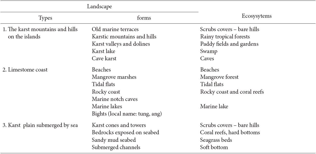
The Cat Ba Islands in Hai Phong City, northern Vietnam, consist of a large limestone island with a maximum height of 322 m above sea level and 366 small limestone islets with a total area of about 180 km2. The islands are relicts of karst limestone mountains that became submerged during the Holocene transgression 7000 ? 8000 year ago. The combination of the longtime karst process and recent marine processes in the monsoonal tropical zone has created a very diversity landscape on the Cat Ba Islands that can be divided into 3 habitat types with 16 forms. The first habitat type is the karst mountains and hills, including karst mountains and hills, karst valleys and dolines, karst lakes, karst caves, and old marine terraces. The second habitat type is the limestone island coast, including beaches, mangrove marshes, tidal flats, rocky coasts, marine notch caves, marine karst lakes, and bights. The third habitat type is karst plains submerged by the sea, including karst cones (fengcong) and towers (fengling), bedrock exposed on the seabed, sandy mud seabed, and submerged channels. Like the landscape, the biodiversity is also high in ecosystems composed of scrub cover ? bare hills, rainy tropical forests, paddy fields and gardens, swamps, caves, beaches, mangrove forests, tidal flats, rocky coasts, marine krast lakes, coral reefs, hard bottoms, seagrass beds and soft bottoms. The ecosystems on the Cat Ba Islands that support very high species biodiversity include tropical evergreen rainforests, soft bottoms; coral reefs, mangrove forests, and marine karst lakes. A total of 2,380 species have been recorded in the Cat Ba Islands, included 741 species of terrestrial plants; 282 species of terrestrial animals; 30 species of mangrove plants; 287 species of phytoplankton; 79 species of seaweed; 79 species of zooplankton; 196 species of marine fishes; 154 species of corals; and 538 species of zoobenthos. Many of these species are listed in the Red Book of Vietnam as endangered species, included the white-headed or Cat Ba langur (Trachypithecus poliocephalus), a famous endemic species. Human activities have resulted in significantly changes to the landscape end ecosytems of the Cat Ba islands; however, many natural aspects of the islandsd have been preserved. For this reason, the Cat Ba Islands were recognized as a Biological Reserved Area by UNESCO in 2004.
Based on the physical characteristics of the land formations and the correlations among morphological features and island landscapes, coastal ecosystems in Vietnam can be divided into four habitat types: limestone mountains, rocky and magma areas, and basal and sandy mountains. Of the 2773 coastal islands in Vietnam, the Cat Ba Islands are the third largest island group, behind the Phu Quoc and Cai Bau islands (An 2008). However, the Cat Ba Islands are the biggest limestone islands in tropical Southeast Asia tropical.
The island group contains one major island, named Cat Ba, and 366 small islands and forms a spectacular and unique landscape. This archipelago has the highest biodiversity in Vietnam in terms of both species and ecosystem diversity, and features characteristics of both coastal areas and islands.
In Vietnam, few publications have focused on landscapes and their relationships with biodiversity (Thanh1998a, Lan and Ken 2005). In particular, no studies to date have examined the relationship between landscape features and biodiversity on the Cat BaIslands, except some descriptive morphomertric studies that have been carried out in recent years (Huy and Thanh 1991, Waltham 2000, Thanh and Waltham 2001), morphormetric topography studies (Historical association of Hai Phong 1990), an assessment of the potential value of the islandsd for tourism development (Thanh 1994) and a description of the potential for natural conservation of the Cat Ba Islands (Thung 2005). Most studies investigating the biodiversity of the Cat Ba Islands have concentrated on the characteristics of the major groups of flora and fauna: marine fishes (Thi 1997), zooplankton (Thu 1997) and reef building corals (Yet el al. 2007). Integrated systematic studies of the ecosystems in the area have been limited in scope and time frame, and their initial results have been general desciption (Thung 2004). In the technical scientific reports submitted to UNESCO for consideration of the Cat Ba islands as a World Biosphere Reserve (Thanh 2002), several characteristics of the landscape and species/ ecosystem diversity were described in depth. However, the importance of the relationships between landscape and ecosystem features has been largely underestimated.
The variation in the landscapes in this area contributes to the maintenance of high biodiversity; studies of the landscape and its relationship with ecosystem diversity and functioning are invaluable to the understanding of biological diversity in the region. A better understanding of the relationship between ecosystem and landscape features may significantly change the trajectory of applied sciences, such as sustainable development and biodiversity conservation, as well as increasing the focus on coastal and island ecosystems. However, these complex relatioships have not been well studied in Vietnam (Thanh 1998b) and this area of investigation is considered as a new field. In this paper, we provide an overview of the landscape in the limestone area, the local ecosystems, and their relationships. The study can provide a baseline for more in-depth studies in the near future.
Location and topography of Cat Ba Island
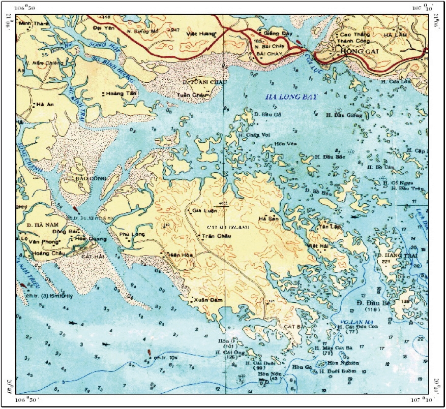
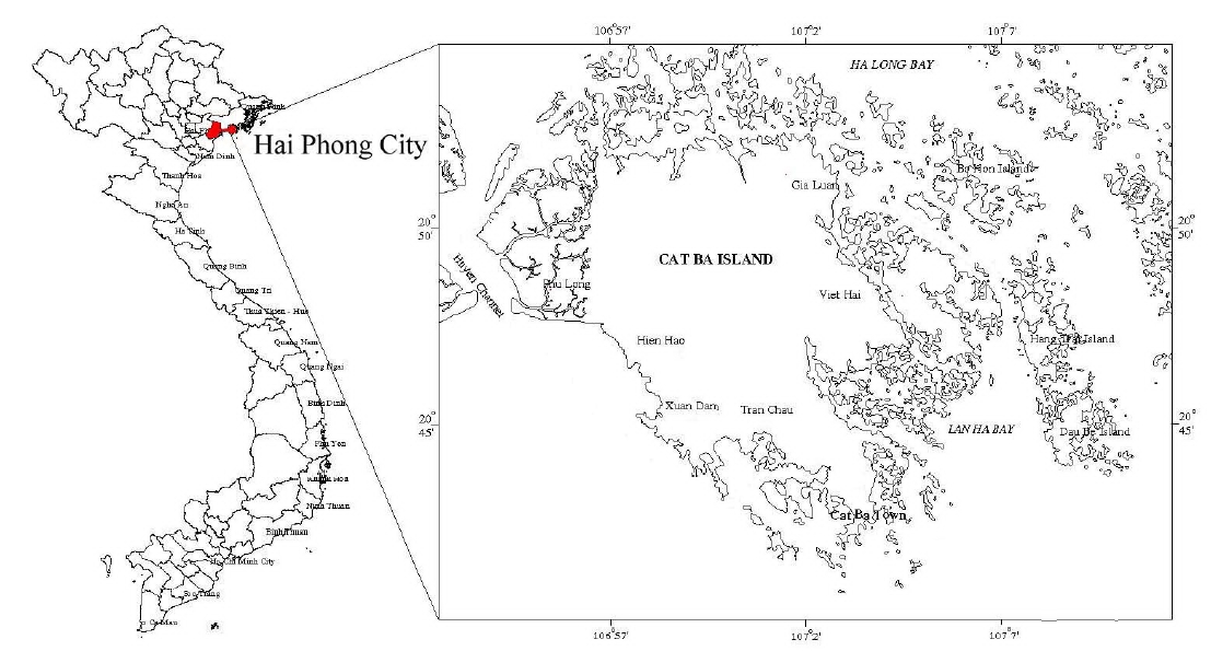
Located between 106°54'11˝-107° 07'05˝ and 20°42'40˝-20°52'45˝, Cat Ba Island is situated in the northwest margin of the Gulf of Tonkin and forms the coast of the Ha Long Bay. The island and neighboring islets are part of Hai Phong City., The Cat Ba Islands are composed of Cat Ba Island, a large limestone island, and 366 small limestone islets with the total area about 180 km2. The islands are relicts of karstic limestone mountains that were submerged by the sea during the Holocene transgression 7000-8000 year ago (Fig. 1).
Except for the highest peak on Cat Ba Island, which reaches 322 m above sea level, the heights of the topographic steps on the islands can be divided into three ranges: 140-220 m (140-160; 170-190; and 200-220 m) - the highest summits may correspond to the Pliocene planation surface; 50-130 m (50-60; 70-90; and 100-130 m), which is the most widespread height class, comprising 59% of the total area,and reflects the development stage at the beginning of Quaternary; and 10-14 m, the topographic step directly influenced by the sea in the late Pleistocene - Holocene. In addition, the island group contains old marine terraces such as the 10 m Ao Coi terrace, the 4.5 m Cai Beo terrace and 2-3 m marine modern (late Holocene) terraces.
The topography of the seabed around the islands has very little relief, and the greatest proportion lies at depths of <10 m, which is compatable with its origins as a subaerial karst plain that has been subsequently drowned by the sea. Cutting the sea floor is a drowned discontinuous valley that reaches depths of 20-30 m. Segments of valleys that lay between caves and carried rivers the through intervening limestone ridges are now masked by extensive accumulations of clastic sediments. In other areas, bedrock exposed on the sea floor forms a basement for the development of coral reefs (Fig. 2).
Factors influencing the landscape and ecosystems
The Cat Ba-Ha Long area lies in the Duyen Hai Zone of the Caledonian-Katasia structure, which was affected by orogenic movements during the early Palaeozoic era. The dominant uplift movement of the neotectonic and recent tectonic, and a fault system in a mainly northeastsouthwest direction has deeply influenced the topography of this area. The bedrock formations in the Cat Ba Islands consist of limestones of Paleozoic age such as the Pho Han, Cat Ba and Quang Hanh formations (Toan 1995).
With a thickness of 400-650 m, the Pho Han Formation (
The bedded limestones of Cat Ba Formation (
The limestones of the Quang Hanh Formation (
On the islands, the undivided Quaternary sediments include delluvium, prolluvium and colluvium with fine, coarse, and very coarse grains (blocks) filled with negative karst reliefs such as: valleys, funnels, karst caves. The late Pleistocene sediments consist of clastic marine sediments such as pebbles, gravels and grit, and brownyellow sand containing a lot of mollusk and coral pieces in marine terrace of 10 m height in the western part of Cat Ba Island, and the Trung Trang valley.
The early-middle Holocene sediments are mainly beach facies of sand and gravel, containing many pieces of corals and mollusks, found in a limited area in the southwest area of the emain island, and 4-5 m high narrow marine terraces. The sediments of marsh and tidal flat facies are found in some cores in the northwest area of the main island.
The middle-late Holocene and modern sediments consist of various coastal marine facies. The beach sediments are expansive, and consist of quartz and lime sands. In some places, 60-90% of sediments consist of lime sands of biological origin. The sediments of tidal flats are comprised of medium and fine sand, and muds mixed with pieces of shells and corals and a little organic humus. The mangrove marsh sediments are found mainly in the northwest of Cat Ba Island, and include clay, silty clay mixed with biological lime pieces, a lot of organic humus, and mangrove relicts.
The surface sediments of the seabed are primarily grey and dark grey silty clay and clay mud with high moisture content. On the southeast sea bottom, 70- 98% of sediments have a grain size of <0.05 mm and the carbonate component reaches 70% in the clay mud. On the coral reefs, the sediments are derived mainly from cracked pieces of corals, molluscs, crustaceans, echinoderms, sponges, foraminifera, lime algae, etc.
The Cat Ba area is located in the monsoon tropical zone with a southwest monsoon from April to September and a northeast monsoon from October to March. The weather is warm, rainy and wet in the summer (southwest monsoon) and cold with little rain in the winter (northeast monsoon).
The wind regime is influenced by the general atmospheric circulation and changes seasonally. The annual average wind speed is 2.4 m/s, with a maximum in July (3.4 m/s) and a minimum in January (1.8 m/s). During the southwest monsoon, the southeast and south wind directions are dominant at an average speed of 2.5-3.0 m/s, with a maximum of 20-30 m/s. During the northwest monsoon, the northeast and north wind directions are dominant with the average speed of 2.5-3.0 m/s, with a maximum 20-30 m/s. Annually, this area is influenced directly by 1-2 typhoons and indirectly by 3-4 typhoons occurring mainly between June and September. During the typhoons, wind speeds can reach 40-45 m/s.
The air temperature averages about 23.3℃ annually; over with tempereatures averaging 25℃ in the summer (from May to September), with highs from 37-40℃ and averaging <20℃in winter (from November to April), with lows from 8-10℃. The average solar radiation reaches 110-115 kcal/cm2 per year.
The rainy season occurs from May to October, with a dry season from November to April. A total of 1,806 mm of rain falls per year (range = 1,600-2,000 mm). In the rainy season, 1,500-1,600 mm of rain falls, which comprises 80-90% of total annual rainfall. Total evaporation reaches 700-750 mm/year, or approximately 50% of total rainfall of a year. The relative humidity is quite high, with an annual average of about 85%.
River and stream systems are not developed on the Cat Ba limestone islands. Temporary streams appear in the rainy season and disappear right after the rains. In the rainy season, water pools in small areas, and is absorbed into caves drop by drop. Although this pooled water comprises a relatively small amount of total rainfall, it is a crucial source of water for animals on the island. The biggest water source is the Thuong Luong stream, with an average dischage of 5 l/s: 7.5l /s in the rainy season and 2.5 l/s in the dry season. This is an important water resource for the islands and local communities. Although the islands are primarily limestone, they contain pools of underground water originating from rainwater. In nature, these are karst valleys filled with sediments supplied from rocky weathering. There are currently six drilled wells on the main island with a capacity of 1,500-2,000 m3/day and the allowable exploitation is about 1,000 m3/day.
The tide in the marine area follows a regular diurnal regime with the maximum range of 4 m. Sea levels are impacted primarily by tidal levels, with a mean sea level of 1.90 m, The highest sea level is 4.21 m, and the lowest sea level is 0.07 m.
The current around the islands is created mainly by tidal currents, with an average velocity of 10-20 cm/s, but it can reaches 50 cm/s in narrow channels. Maximum wave heights during much of the yeaer are approximately 2 m, but wave heights may reach 4-5 m in typhoons. Northeast waves have an average height of 1.0-1.5 m from October to March, and southeast waves have an average height of 0.5-1.0 m, with waves of heights up to 2.8 m often occurring from May to August.
The seawater temperature in the area changes frequently, depending on the air temperature. In the rainy season (from May to October) the sea temperature ranges from 21-31℃, while it ranges from 15℃ to 20℃ in the dry season (from November to April). The salinity of Cat Ba seawater ranges from 19% (in August) to 34% (in February). The average salinity is about 28% in the rainy season, and about 32.5% in the dry season. The pH of seawater in the Cat Ba Islands does not change much, ranging from 7.9 to 8.3. The water turbidity in this area appears to be increasing with the time. It ranges from 20- 50 mg/l in the rainy season, and from 10-30 mg/l in the dry season.
The soils in the Cat Ba Islands are produced by an interaction between the limestone bedrock, the karst landforms and the humid tropical climate. the limestone hillsides of small slopes and limestone holes have 30- 40-cm layers of reddish-brown feralit soil that is rich in humus but not sour. A typical profile for this soil is
The reddish brown feralit soil in the mountains and foothills is accumulated sediments from materials drifting from the peaks and slopes of mountains or hills. This soil layer is rather thick, with depths ranging from 50-100 cm, and is high in humidity and rather closed in structure. It is from medium to heavy in weight and rich in humus resulting from the abundant flora.
Yellowish brown feralit soil derived from mixedweathered materials of limestones is distributed in valleyswith surface streams, such as the Trung Trang, Viet Haiand Gia Luan valleys. This soil is neutral in reactivity; notvery sour and rich in humus. This soil is droughty in thedry season, but its lower part can be inundated duringheavy rains. This soil is suitable for growing fruit treesand farm products.
Alluvial soil ranging from 880-100 cm in thickness is distributed in the karstic valleys and dolines. This soil is, yellowish brown or light yellow in color, neutral to sour, partly inunded in the rainy season, and droughty in the dry season, and can be used for planting rice or farm products.
The western coast of the main island contains a 40- ha area of alkaline-acid alluvial soil that originated from tidal marshes that were reclaimed using sea dykes for development of two-crop rice fields. Finally, alkaline mangrove soil is distributed on the northwest coast of the main island and on some small islets. Mangrove forests develop abundantly on this soil.
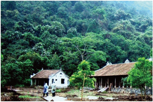
Human activities have contributed to changes in landscapes and ecosysytems in the area of the Cat Ba Islands. Humans have occuppied the Cat Ba Islands for millennia. There is archaeological evidence of prehistoric cultures on the islands, including the Soi Nhu Culture (25,000-7000 y BP) in the caves on the Cat Ba islands; the Cai Beo Culture (7000-5000 y BP) in a marine terrace on the western coast of the main island (14C age: 5645-60 y BP); and the Ha Long Culture (4500-3500 y BP) in many sites, including islands in the Cat Ba-Ha Long area (Nga and Hao 1998, Thanh 1998b).
[Table 1.] Landscape evolution of the Cat Ba Islands during the latest Pleistocene - Holocene time.
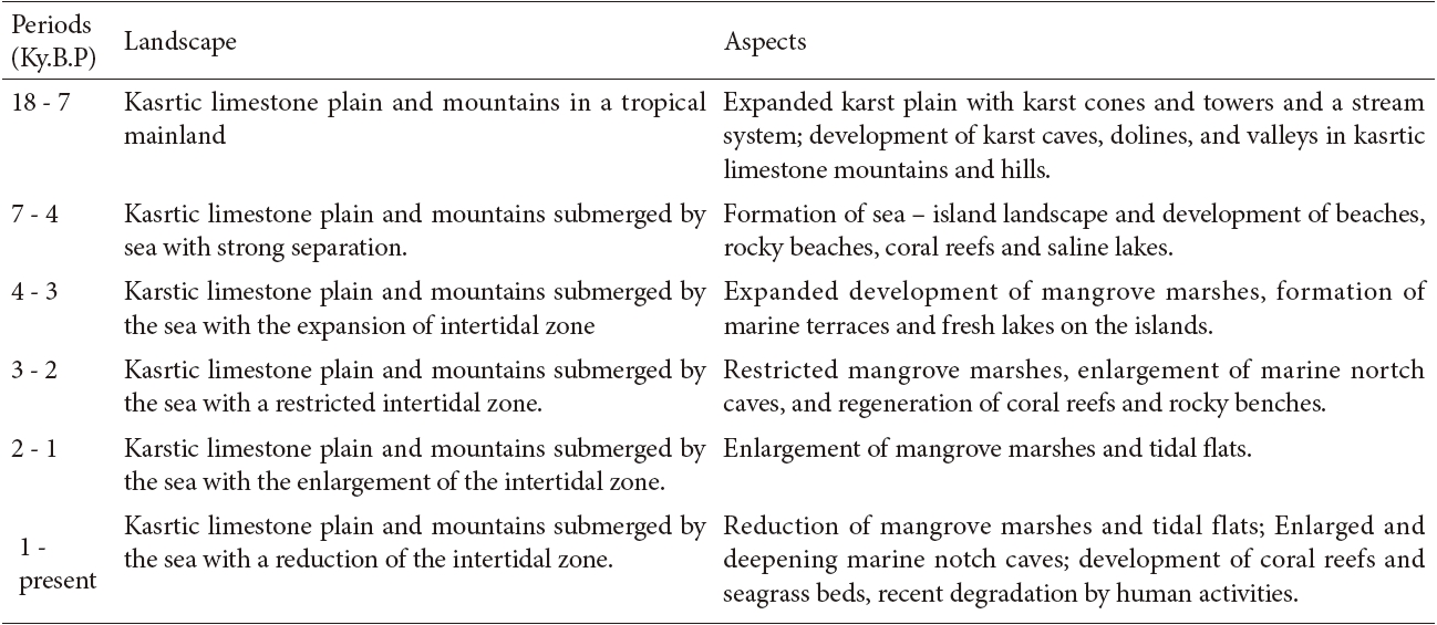
Landscape evolution of the Cat Ba Islands during the latest Pleistocene - Holocene time.
Now days, humans only inhabit the main island, and are concentrated in Cat Ba Town or scattered in six communes. The local population has increased rom 5850 persons in 1986 to 8400 people in 1996 and 14394 persons in 2006, and is forecasted to increase to 15127 persons in 2010 and 20242 persons by 2020. Accordingly, the area of human land use for building infrastructure has also increased, from 304 ha in 2000 to 346 ha in 2000 and is projected to increase to 437 ha in 2020.
Recently, the economy of the Cat Ba area has been developing rapidly in the sectors of tourism, fishing, aquaculture (ponds, cages etc), fishery services, and water transportation. For example, 250,000 tourists came to the Cat Ba Islands in 2003 and 500,000 people visited the islands in 2006. Up to one million visitors are expected in 2010, and forecasts predict that 1.9 million people will visit the island in 2020.
Although, the Cat Ba Island were designated as a National Park by the Vietnamese Government in 1987 and as a Biological Reserved Area by UNESCO in 2004, economic development and population growth continue to negatively affect natural landscapes and ecosystems in the Cat Ba Islands.
The Cat Ba area has a long geological history. The mainland environment in this area developed during the Mesozoic and early Cainozoic, and terrestrial karst process also started at that time. In the Quaternary, this area came to consist of sea islands with marine notches and terraces at different heights. However, the area developed as the result of sinking in the last post-glacial transgression (the Flandrian transgression), which started 18 000 years ago (Tri et al. 2003).
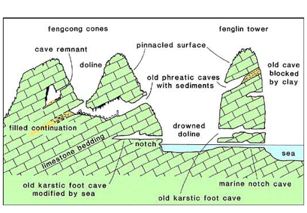
The geomorphology of the Cat Ba area is an excellentexample of mature karst developed over a basementof limestone formations over 1500 m in thickness, inthe condition of a hot, humid and rainy climate, andwith a background of general slow neotectonic uplift,with an integration of sea, land and air factors. Thekarstic evolution of the Cat Ba limestone area must havecontinued through much of Neogene (20 M to 2 M yearsago) and Quaternary (2 M years ago ? present), as maturefengcong (cone) and fenglin (tower) landforms canonly evolve over millions of years of erosion and surfacelowering. This process has passed through five stages:1) formation of an ancient plain; 2) formation of karsticdolines and valleys; 3) formation of groups of conjunctiveconic hills (fengcong); 4) development of separated hightowers (fenglin); 5) formation of a new plain (Waltham2000, Thanh and Waltham 2001).
As sea levels were low during the Pleistocene glacial periods, much of the Gulf of Tonkin was dry land during the Pleistocene, although the sea sometimes transgressed along the river valleys. Before this period, and especially since the Neogene, karstic erosion by dissolution of the limestone developed the landscapes of the Cat Ba Islands and neighbouring areas. There was high rainfall, and river systems that are still recognizable by their seabed channels were part of the karstic erosion processes and created the cone and tower karst with dolines, valleys, caves and underground streams. Karstic plains and upland blocks were carved by erosion in a continental environment. That was a basic factor in the formation of Cat Ba islands before the sea trangressed across the area. The sea bed around the Cat Ba islands is a kind of plain on which the relief has been modified by later marine erosion. Sediments have accumulated on the karst plains that have formed the seabed since the Holocene transgression (Table 1).
The present landscape of sea-islands was formed around 7000-8000 years ago by sea invasion during the Holocene transgression that begun about 17000-18000 years ago. The landscape formation and evolution of limestone islands can be divided into 6 stages (Table 1) corresponding to changes in sea level (Lam and Boyd 2002, Thanh 1998b).
Characteristics of the Cat Ba landscape
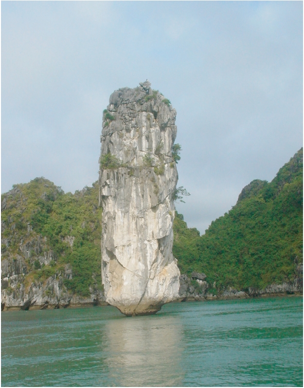
Karst lanscape: The Cat Ba archipelago formed adjacent to the Ha Long karst plain under the impacts of erosion from the sea, which has contributed to the attractiveness of the Ha Long Bay and other surrounding limestone islands (Waltham 2000).
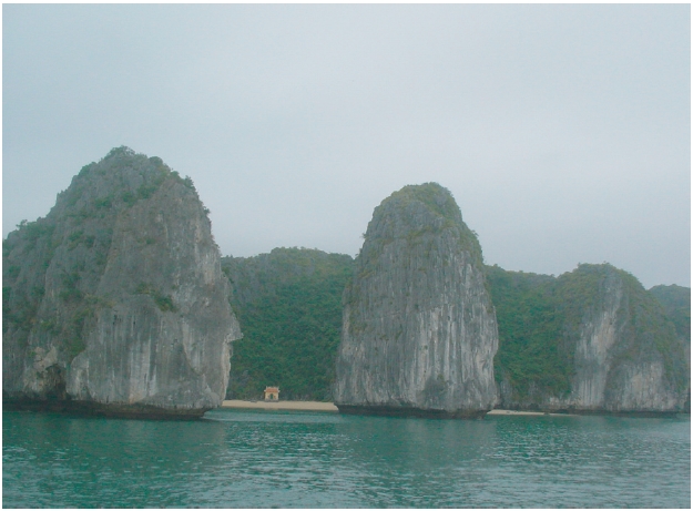
Aside from Cat Ba Island (the major island), other limestone islands in the vicinity of the Cat Ba - Ha Long archipelago have various morphologies and sizes. Several island groups are classified as the Fengcong type or the Fengling type, consisting of individual islands with very high straight cliffs. Below the island platform from the high tide zone downward, there are many concavitiese due to the erosion of limestone in seawater. At low tide, people can see a paradise with hundreds of limestone islands growing upward - a unique character of the submerged karst area.
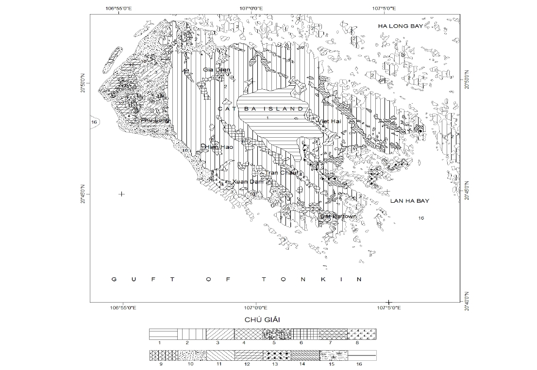
Fenling and Fencong karst topography: The major Cat Ba Island, the largest island, is surrounded by 1,969 islands in connection with the Ha Long Bay group, with a density of 1.27 islands/km2. Various sizes of micro- (0.01- 0.0001 km2) or small (0.1-0.01 km2) islands comprise 91.5% of the islands and 25.79 % of the total island area (Thanh 1998b). Only seven islands have total areas >1 km2, of which the biggest is Hang Trai Island (4.613 km2).
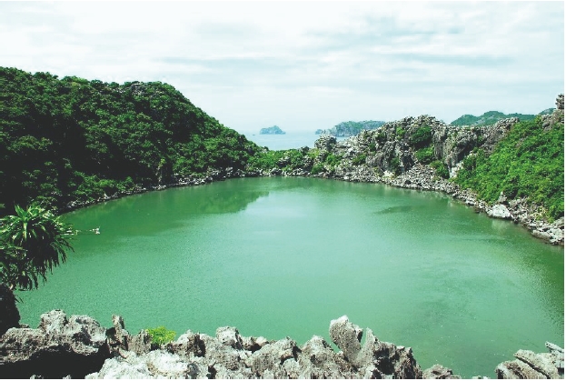
Funnel karst and marine lake: The funnel karst and marine lakes are very popular attractions in the Cat Ba and Ha Long islands. They have a diversity of sizes and shapes. Because most of the time, they are submerged and become the marine karst lakes (or brackish water lakes), they make a beautiful landscape and provide a good environment for marine species (Tri et al. 2003). The isolated environmental conditions can create favorable conditions for speciation or the evolution of unique species. The marine lakes normally have a water depth of 1-3 m and a bottom cover of sand, muddy clay. Typical areas are 1-5 ha with the Vem marine lake considered to be the largest at 28.8 ha (Thanh 2002).
[Table 2.] The number of islands of the Fenling and Fencong tyes and the K index
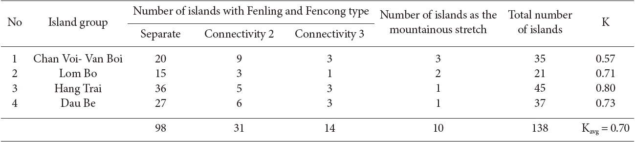
The number of islands of the Fenling and Fencong tyes and the K index
Karst cave: Cat Ba and Ha Long Bay contain a large number of the karst caves. The karst caves normally stretch from from tens to hundreds of meters in length, and are distributed at three levels: level 1 with a height of 3-4 m and linkages with the sea, level 2 with the largest size at the height of 5-15 m and level 3 at the height of 25-50 m (Thanh 1998b, Waltham 2003).
Sea notches: notches made by the effects of sea waves on the rocky cliffs contribute to the spectacular landscape of the limestone islands in the coastal area. Notches are found at various levels: 2.0-2.5 m, 3-5 m, 7-8 m and 9-12 m. Initial studies using C isotopes of the bivalvia group stuck on the rocky surface (Thanh 1998b) showed that notches 7 m and up represent geological ages of >;32000 years ago in the late Pleistocene (Q1 3); while notches from 5-6 m and below formed in the middle Holocene (Q2 2) period about 6000- 5000 years ago.
>
Tropical evergreen rainfores landscapet
Tropical rainforests on the Cat Ba Islands are chracterized by tropical evergreen plants. However, due to the unique topography, soil and hydrology of the area, they can be subdivided into subtypes such as: tropical rainforest on limestone, shrubs, green grass and submerged forests on limestone islands.
Rice paddies and fruit farms: Fruit farms, with lychee as the target fruit and other fruits such as orange (Gia Luan) and longan (Xuan Dan), have been planted at Trung Trang. Among these fruits, the lychee is the dominant plant occupying 37 ha, followed by oranges (7.2 ha). The farms all result in good harvests and provide stable income for farmers. Cat Ba does not have much land that is appropriate for rice cultivation. There are about 200 ha of rice paddies that can be planted twice/ year. Rice is also planted in the winter-spring season over an area of 21 ha (17ha in Xuan Dan and 4 ha in Hien Hao. Larger areas are planted in the summer-autumn rice season: Xuan Dan (62 ha), Tran Chau (55ha), Hien Hao(27ha) and Viet Hai (28ha). Other vegetables planted include corn, sweet potatoes, peanuts and cassava.
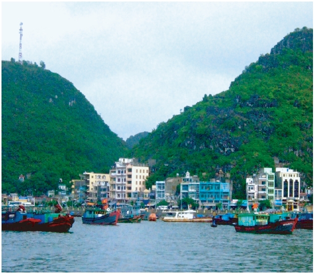
Residential areas: Residences are concentrated in seven main areas in Cat Ba town and communes such as Gia Luan, Phu Long, Hien Hao, Xuan Dam, Tran Chau, and Viet Hai. The landscape in the residential areas has rapidly changed with the building of new modern houses and a chain of hotels and restaurants to meet the demands of the tourists that visit the Cat Ba Islands, especially during the summer months (the peak time for tourists).
>
Shoreline and bottom landscapes
Island shorelines
Cliff and beach rock: The topographic factors of Cat Ba Island form horizontal banks. Each shoreline bank responds to topographic dynamics and shows major or minor effects of topogrphic changes. Cat Ba Island consists of 11 types of horizontal banks (Waltham 2003).
Cliff and beach rock: The topographic factors of Cat Ba Island form horizontal banks. Each shoreline bank responds to topographic dynamics and shows major or minor effects of topogrphic changes. Cat Ba Island consists of 11 types of horizontal banks (Waltham 2003).
Muddy sand beach: Aside from the 2000-ha Duong Gianh tidal flat, the lower areas consist of fine muddy clay in a green color. These areas are mainly distributed in the north of Cat Ba Island. Angke tidal flat is 50 ha in area, with an average height level of 0.5/0m above sea level. Other beaches with areas of 3-5 ha are located along channels. In some places like Vuon Qua, the areas adjacent to the beach are partly covered with mangrove forest.
Embayment: Small bays eroded inside of the limestone islands, originating from channels and submerged karst as a result of sea level changes. A total of 57 embayments are found in the Cat Ba and Ha Long area. The largest embayment is called Tung Gau (220 ha) and smallest one is named May Den (1.5 ha) (Thanh 2002).
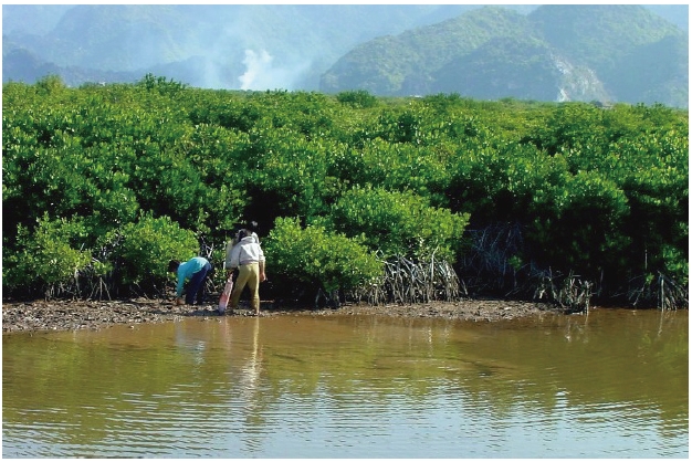
Mangrove forest: Mangrove forests are distributed on tidal flats in the northwest areas of the island such as Cai Vieng, Phu Long and several small beaches in Xuan Dam, Gia Luan, and Ang Soi. The forests are characterized by ony one level of trees with heights ranging from 1-2 m to 4 m and high plant density.
Aquaculture and shore infrastructure: Aquaculture ponds were constructed on tidal flats, mostly in the northwest of Cat Ba Island in areas such as Phu Long, Cai Vieng, and Duong Gianh, and were also built in small embayments in the marine lakes and embayments surrounding Cat Ba, such as Ang Soi, Ang Tham, and Tung Gau. Mangrove trees can develop in some ponds that have good exchange of water with outside areas, and can occupy up to 34% of the total area of aquaculture ponds. In other ponds, most mangrove trees were depleted because of the absence of water exchange.
The shore infrastructure includes ferries (Phu Long, Gia Luan), a tourist boat port (Ben Beo) and a fishery harbor (Cat Ba bay). In addition, provincial roads connecting Cathai to Cat Ba town and the connecting road from Cat Co 1 beach to Cat Co 2 play important roles for tourists visiting Cat Ba island.
Bottom landscape
Submerged karstic valleys and plains: Submerged karstic valleys form waterways, most of which are oriented NW-SE, extending 5-10 km, with a depth of 10-20 m. The floor of the Cat Ba - Ha Long Bay consists of a karstic plain lat a depth of 3-20 m, the surface of which is complicated with many relict mounds, furrows, ditches of clear stepping character: 1-4 m; 6-11 m, and 12-20 m, reflecting the abrasion-corrosion stages before submersion; in many places there are reef-forming corals. This karstic plain, formed since the Middle Holocene, is surrounded by an island system. Therefore, it is not subjected to the impact of waves and due to the high amplitude of tides (4 m maximum) both accumulation and erosion occur (Thanh 1998b).
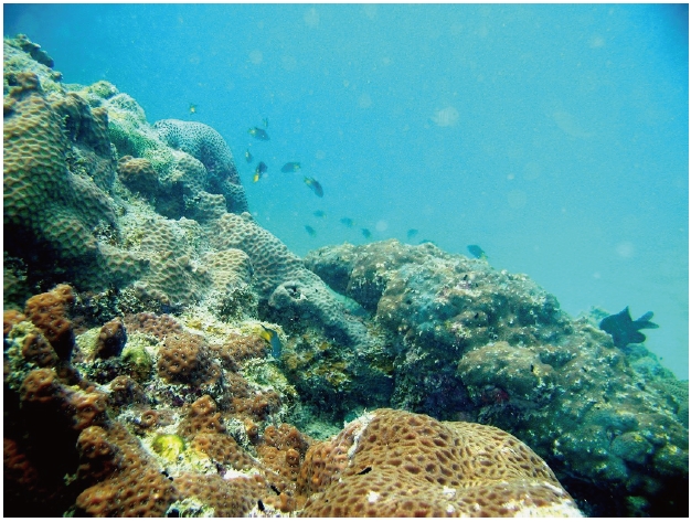
Coral reefs (fringing reefs, unofficial atolls): The coral reefs in the Cat Ba - Ha Long area include fringing reefs, island-connecting reefs and unofficial atolls.
Fringing reefs, where coral developed partly along the shoreline, are considered to be the major reef type. In unofficial atolls, corals encircle the shoreline, as in atolls. The connecting type occurs where corals develop and connect two idependent limestone islands located a small distance (meters to tens of meters) apart, forming a bridge between the islands.
[Table 3.] Species recorded on Cat Ba Island
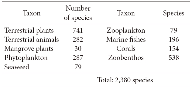
Species recorded on Cat Ba Island
Biodiversity values of the Cat Ba island
>
Diversity of the species composition
A total of 2,380 species have been recorded on Cat Ba Island, of which 1053 species (51.7%) are terrestrial species and the remaineder (985 species, or 48.3%) are marine species (Table 3).
Tropical evergreen rainforest: Limestone forests with two tree layers, 15-20 m and 10 m, are found on limestone ridges. The total area of rainforest on Cat Ba Island is 46.2 km2, which comprises 32% of the total area of Cat Ba Island (Thanh 2002). Primary and secondary forests are mainly distributed in the central and northwestern areas of Cat Ba Island. Valleys and hilltop areas are partially covered by plants with low coverage. One hundred and forty-five tree species and 69 medicinal plant species have been found on Cat Ba island. Thirtyeight species of mammals in seventeen families have been recorded in Cat Ba National Park, including bats, rodents, carnivores, ungulates, primates and insectivores like moles and shrews. The animals in Cat Ba National Park can be further classified as (1) Endemic fauna: 1 species, (2) Valuable and rare fauna: 5 species, (2) fauna used for medicine: 20 species; (3) fauna used for decoration and exported: 15 species; (4) fauna used for leather and hair: 9 species; (5) fauna used for food: 23 species.
Soft bottom ecosystems: These ecosystems include most of the sea bottom (except the coral reefs) and surrounding waters. They contribute most of the marine resources. Phytoplankton are the keystone species in this habitat type, providing basic food items for the zoobenthis and fish that are the key targets of the capture fishery.
Coral reef ecosystems: Coral reefs are mainly distributed in the waters southeast of Cat Ba Island, such as Cong La, Ang Tham, Ba Trai Dao, Van Boi, Cong Hip, Tung Ngon, and Coc Cheo. Coral reefs and the surrounding areas are the major fishing grounds for reef fisheries due to the high values of coral reef fishes and associated reef species.
Mangrove forest ecosystems:Mangrove forests and coral reefs are invaluable natural resources of the tropical countries in general and Cat Ba in particular. They act as the sources of genetic diversity, increase the natural biomass and stablize the shoreline. Most of the mangrove forest cover is on the western side of Cat Ba Island (Phu Long Natural Reserve). In the near future, ecotourists are expected to particularly favor these green corridors.
Marine karst lake ecosystems:Marine karst lake ecosystems give a unique chracter to the Ha Long-Cat Ba area. To date, 62 lakes have been recorded in the area, with more than 30 lakes were in Lanha Bay and the adjacent areas (Thanh 2002). The lakes have relatively small areas ranging from 0.8 ha to 28.8 ha. Biodiversity in these lakes is generally low. More studies should examine patterns of evolution and speciation in these lakes, because they are almost completely isolated from the waters outside. The beautiful landscapes created by the lakes are also favorable to the development of the ecotourism activities on Cat Ba Island.
Marine karst lake ecosystems: Marine karst lake ecosystems give a unique chracter to the Ha Long-Cat Ba area. To date, 62 lakes have been recorded in the area, with more than 30 lakes were in Lanha Bay and the adjacent areas (Thanh 2002). The lakes have relatively small areas ranging from 0.8 ha to 28.8 ha. Biodiversity in these lakes is generally low. More studies should examine patterns of evolution and speciation in these lakes, because they are almost completely isolated from the waters outside. The beautiful landscapes created by the lakes are also favorable to the development of the ecotourism activities on Cat Ba Island.
Di versification of the landscape and relationship with the ecosystem
[Table 4.] Relationship between landscape features and ecosystems

Relationship between landscape features and ecosystems
A matrix showing the relationship between diversification in landscapes and ecosystems should be understood as indicating a two-way correspondence (Table 4). In some cases, the landscapes provide a basis for the development of living organisms. For example coral reefs cannot develop in an area without a suitable substrate. When coral larvae settle in a suitable habitat, they will develop naturally and contribute to a beautiful ocean-bottom landsacpe. In addition, the occurence of an ecosystems will help conservationists or resource managers decide how best to conserve the landscape through the maintenance or rehabilitation of natural ecosystem functions.
Assessment of threats to landscapes and ecosystems
>
Increasing human settlement areas
Prior to 1979, the human population of Cat Ba island was relatively low. However, since this time, large numbers of migrants from the mainland have settled on the island. In 1999, the total population of Cat Ba Island was 10,673 people. While 70% of these people inhabit Cat Ba town, and are mainly employed in the fishing, trading or service industries, the inhabitants of the villages in or near the core areas are farmers, and exploit forest resources intensively. Due to high human pressure resulting from population growth, the coral reefs at the site are being threatened by siltation, dynamite fishing and excavation.
>
Over-exploitation of resources
The forest resources most widely exploited are timber, fuel wood, honey, bamboo shoots, edible roots, frogs and geckos. Honey collection takes place in the forest between August and November and in May. Groups of honey collectors spend one to two weeks at a time in the forest, during which time they hunt in order to supplement their diets. In addition, the practice of honey collection often results in forest damage.
Hunting seems to be the main threat to animal populations on Cat Ba Island, and particularly to the endemic white-headed langur. Between 1970 and 1986, an estimated 500 to 800 langurs were killed, and during the 1990s another 90 individuals were killed or captured. Unless protection measures are improved and the remaining leaf monkey population is carefully managed, this primate faces imminent extinction.
>
Blooming of the tourism activities
In recent years, tourism has become central to the localeconomy. However, uncontrolled tourism developmenthas begun to pose a threat to the island’s environment,a fact now acknowledged by the National Park staff. Ifit is developed with environmental sensitivity, however,tourism has the potential to make a positive contributionto the conservation at Cat Ba National Park by generatingrevenue and raising environmental awareness.
The landscapes of the Cat Ba Islands are relatively diverse, containing 16 forms in three main types, resulting from a mountainous topography and karstic plateau that were submerged by a marine transgression after the last ice age. The tropical karstic characteristics in the area are typical and diverse, and include all the main karstic developments: karstic funnels, karstic fencong, karstic fenling and karstic plateaus. The unequal material contents in the limestone layers contributed to the production of the numerous karstic developments in the same area. Moreover, karstic landscapes in the islands are more diverse due to the effects of the marine transgression on the shoreline about 7000-8000 years ago.
Diversification of landscapes contributes to the maintenance of biodiversity (species/ecosystem diversity) in a region. A total of 2,380 species have been recorded on Cat Ba Island, including1053 (51.7%) terrestrial species and 985 (48.3%) marine species. The five major ecosystem types can be used as key indicators of appropriate landscapes while the coral reef and mangrove ecosystems are classified as typical tropical ecosystems. Fringing reefs have developed in some embayments of the limestone islands, along with rare "unofficial atoll" reefs. In addition, the submerged sea water around the limestone has produced marine karst lakes with their own unique ecosystems.
The isolation of the Cat Ba Islands from the mainland and the high complexity of the limestone topography are key elements promoting biodiversity and permitting conservation of ecosystems and endemic species. However, in recent years, humans have changed the natural landscapes and degraded the ecosystems in this area. The Cat Ba Islands form a beautiful natural museum and their landsacpes and ecosystems, including inland areas and adjacent coastal tropical limestone mountains, must be protected.