Seoul, Keep Your Paddies! Implications for the Conservation of Hylid Species
- Author: Borzee Amael, Ahn Jaeha, Kim Sanha, Heo Kyongman, Jang Yikweon
- Publish: Animal Systematics, Evolution and Diversity Volume 31, Issue3, p176~181, 31 July 2015
-
ABSTRACT
Biodiversity is plummeting worldwide, and the major causes of such decline include habitat degradation and climate change. While cities do contribute to the negative impact to the environment, they can also serve as strategic centres for conservation programs. Sites qualifying as biogeographic islands within metropolitan Seoul were studied for the occurrence of two hylid species: the endangered
Hyla suweonensis and the abundantH. japonica . This study demonstrates that neither habitat diversity nor surface area, but solely the occurrence of aggregated rice paddies is a requisite forH. suweonensis , hypothetically due to its strict breeding requirements. On the contrary,H. japonica occurrence was not affected by any of these factors, and all types of habitats studied were adequate for this species. The presence of an endangered species within the boundaries of one of the most populated metropolises suggests a strong natural resilience, which should be enhanced with appropriate actions. We emphasize that the management plans therein can, and should, be used as the first step in the conservation ofH. suweonensis in metropolitan Seoul.
-
KEYWORD
biogeographic islands , conservation , city of Seoul , Hyla suweonensis
-
Resulting from factors such as climate change and anthropogenic habitat modification worldwide, biological diversity is decreasing at such a speed that it has been termed the “sixth mass extinction” (Wake and Vredenburg, 2008; Wake, 2012). Accordingly, the current rate of extinction is up to 10,000 times faster than the background rate inferred from fossil record (Singh, 2002). Up to 30% of the species currently known are predicted to have disappeared by 2050 (Thomas et al., 2004), subsequently reaching 50% by the end of the century (Singh, 2002). High extinction rates have led to the extensive study of extinction processes for many taxa (e.g., Castelletta et al., 2000), although conservation schemes are still too uncommon and the number of endangered species is constantly increasing (Brown et al., 1998).
Cities and their suburbs are notorious for their negative impact on the environment. Early human settlers were attracted to areas rich in natural resources, which later grew into cities. However, the same areas are equally sought after by other species and are becoming less accessible as cities are expanding (Olson and James, 1982; Steadman, 1995; Myers et al., 2000). For instance, the flood plains where metropolitan Seoul now stands, with roughly 20 million inhabitants, used to be covered by wetlands (Won, 1981), and therefore acted as biodiversity reservoirs (Contini and Cannicci, 2002). When wetlands were drained and built upon, the biodiversity present at the site disappeared through co-extinction, and only biogeographic islands remained. Some exceptions persisted through substitute habitats in the form of rice paddies. These were soon replaced by other human-dominated structures, which slowly pushed species away from their original living sites. This situation is recurrent worldwide, under different modalities, and has brought wetland organisms to the front of the extinction queue (Abell, 2002), in a strongly unbalanced situation that favours terrestrial organisms over their freshwater counterparts (McAllister et al., 1997). Consequently, amphibians have been the subject of severe population declines over the last several decades, with approximately a third of all species under threat of extinction (Wake, 2012), while more than a hundred have already gone extinct (Stuart et al., 2004).
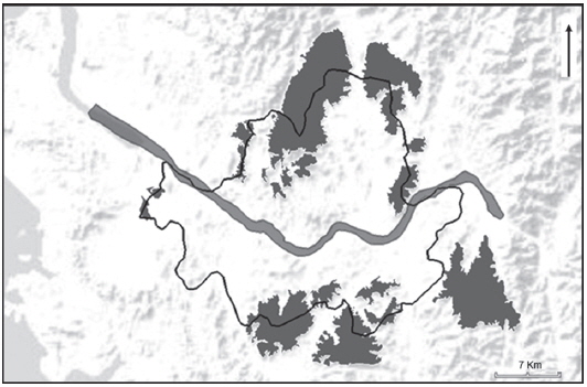
A biogeographic island is similar to a literal island in that it is surrounded by unsuitable habitats, such as urban tracts, that prevent the immediate dispersion of species (Simon, 2008). The city of Seoul is surrounded by a green belt, which is a series of forests and rice fields encompassing the city (Bae, 1998). Residential and commercial developments are typically prohibited in most areas of the green belt. However, this green belt does not amount to a continuous habitat, but to a fragmented continuation of ecologically dissimilar habitats. These are biogeographic islands formed by the complex and abundant urban tracts separating them. The aim of this study was to define the habitat characteristics of the endangered
Hyla suweonensis (Ministry of Environment of the Republic of Korea, 2012; IUCN, 2014a), in relation to the abundantH. japonica (IUCN, 2014b) within metropolitan Seoul. The landscape habitat preferences described for the species (Roh et al., 2014; Borzée and Jang, 2015) were used to discuss the habitat characteristics and then suggest conservation strategies.Biogeographic islands within, or partially included within, the cadastral area of the city of Seoul were identified and characterised for their surface area and distance to the closest island from Google Earth (v7.1.2.2041, 2014; Google, Mountain View, CA, USA). In case an island was only partially within the boundaries of Seoul, we extended the analysis to its contiguous entirety. We also annotated the habitat type from the publicly available database of Daum maps (v 3.9. 12; Daum Communication, Seoul, Korea) dated from 2011 for each island, and no inconstistency were noted with the data from 2014. The limits between geographic islands were defined through landscape barriers that made dispersal unlikely, i.e., physical obstacles that greatly increase mortality risks for most amphibian species (Ray et al., 2002; Roh et al., 2014). We considered roads with four-lanes or wider (Ashley and Robinson, 1996), rivers with a breadth of at least 100 m (Angelone and Holderegger, 2009) and urban area at least 100 m wide (Ray et al., 2002) as landscape barriers between adjacent localities. Golf fields were not included in the definition of biogeographic islands. The surface area was measured at 0.01-km2 resolution and distance with a resolution of 1 m. Habitat was divided into four categories, namely “rice paddies”, “fields”, “forest” and “shrubs”, each of which were identifiable from the maps at the selected resolution. The surface area for each habitat category was converted to a percentage of the surface area of the island. To be defined as a belonging to a specific type of habitat, each patch had to total a minimum of 500 m2. Other landscape and climatic variables were not included in the analysis due to the narrow range of the selected area.
Each island was given a score of 1 for each 10 km2 of surface area, a score of 1 for each habitat present, based on the main factors of importance (Wesche et al., 1987; Lomolino, 1990), and a score of 1 if closer than 200 m from the next island, concurring with the range of yearly dispersion distance for hylids (Angelone and Holderegger, 2009). The presence or absence of the focus species was encoded as 0 or 1, based on field surveys conducted between 15 May and 1 July 2014, matching with the breeding season of the species. Each site was surveyed once, following a transect line for a minimum of 15 min crossing the expected adequate breeding area of the species, which has been determined as an adequate method to detect hylids (Sung et al., 2011). Descriptive statistics and habitat ranking were computed for each site, based on the scores attributed. We then used a logistic regression to measure the relationship between the occurrence of
Hyla suweonensis , set as the dependant factor, and the five habitat variables, with the distance between islands and surface area set as independent continuous variables. The analysis was not run forH. japonica due to the consistent occurrence of the species. The output of the analysis allowed using the probability scores as the predicted values of the dependent variable, hereby the occurrence ofH. suweonensis . Subsequently, we tested the directionality of the relationship between the occurrences ofH. suweonensis and the habitat types “rice paddy” and “forest” with a Spearman’s rank-order correlation test. All statistical analyses were conducted in SPSS (ver. 21.0; SPSS Inc., Chicago, IL, USA).The analysis of the biogeographic island within metropolitan Seoul accounted for a total of 19 sites (Fig. 1). The surface area ranged from 1 to 88 km2 with a median value of 5.97 km2. The distance between two islands ranged from 81 to 3,590 m, with a mean value of 685 m (SD=902.90). The habitat type “forest“ was represented by the highest frequency, being present for 17 out of 19 sites, while the two sites not displaying any forest were the only sites where rice paddies dominated. Fields and shrubs were accounted for at respective frequencies of 4 and 3 (Table 1).
Hyla japonica was present at all sites surveyed, and it was therefore not possible to discriminate the factor important for the occurrence of this species.The habitat ranking ranged from 2 to 8, with high ranking habitats present at the lowest frequency, ranging from 6 to 2. More than half of the islands were characterised by a rank below or equal to 3 (Table 2). Unexpectedly, the presence of
H. suweonensis coincided with the sites of lowest rank. The results of the logistic regression for the presence ofH. suweonensis indicated that forest (score=16.97, df=1, p<0.001) and rice paddies (score=19.00, df=1, p<0.001) were statistically significant. However, the distance between islands (score=0.06, df=1, p=0.784), the surface area (score=0.60, df=1, p=0.440), and the habitat variables “field” (score=0.57, df=1, p=0.452) and “bush” (score=0.37, df=1, p=0.543) were not statistically significant. The subsequent Spearman’s rank-order correlation test showed thatH. suweonensis was negatively correlated with “forest” (rho= - 0.58, n=19, p=0.010) but positively with “rice paddy” (rho=0.99, n=19, p<0.001).Although the correlation between the surface of a protected area and the number of species was demonstrated for mammals (Newmark, 1987) and in general settings (Quammen, 1996), it does not apply to hylids with narrower home ranges. Urban areas are typically characterized by a few biogeographic islands with low to high quality habitats, surrounded by urban environment. Seoul being a massively populated city, our results are consistent with the low biodiversity expected from a metropolis. Yet, two sites displayed high rankings, denoting a potential for the conservation of biodiversity within metropolitan Seoul. These sites are adequate for
Hyla japonica , which appears to be a highly vagrant species for which the size, distance to the next biogeographic island and type of habitat are not critical for its occurrence. This translates into low requirements for breeding sites, and the appropriateness of any wetland for egg deposition and larval development. Oppositely, the presence ofH. suweonensis at the two sites with the lowest ranking highlights the fact that biogeographic islands may benefit from diverse vegetation types, but specific features are required for some species.Hyla suweonensis does necessitate a specific type of habitat and seems not to be affected by the variety of vegetation types, as long as rice paddies are available at the site. Thus, biogeographic islands of all types should be conserved. Furthermore, this finding shows that a single habitat is required forH. suweonensis and suggests that rice paddies may be adequate for hibernation.Increasing the habitat suitability of the biogeographic islands, with no
H. suweonensis at present, would allow for the possible extension of the currentH. suweonensis population. An increase in habitat suitability would involve the creation of artificial wetlands at the lowest elevation of other biogeographic islands on the green belt surrounding Seoul. Wetlands as small as 4 hectares are known to be suitable as potential hosts toH. suweonensis (Borzée and Jang, 2015). These newly created wetlands, kept natural or artificial in the form of rice paddies, could therefore be an important addition to the value of the city of Seoul, and create a link betweenH. suweonensis populations north and south of the city, as the city is located at the heart of the geographic range ofH. suweonensis . An increase in the habitat suitability would also mean the stabilisation of populations as the immigration rate decreases for habitats with a high suitability index, partially correlated to habitat ranking, due to saturation with species (Simon, 2008). Equally, it would result in a higher colonisation rate and a potential range extension for the species, as biogeographic islands with high habitat ranking indices have a high emigration rate, correlated to the high number of dispersing individuals (Simon, 2008). This positive effect would outweigh the current situation forH. suweonensis , where all populations are located in biogeographic islands with low habitat rankings and are consequently subjected to higher probability of extinction due to ecological decay and chance events.The beneficial aspect of population connectivity through wildlife corridors (Bennett, 1998) is shown by the landing strips of the international airport of Gimpo, between the two islands where
H. suweonensis is present, acting both as an ecological buffer and corridor. Ecological corridors between the existing biogeographic islands withH. suweonensis and other sites where the species occurs would decrease the risk of genetic bottleneck, and lower the risk of extinction (Frankham, 2005). Specifically, structures such as the ecobridge in Namhyeon-dong (37.475582°N, 126.970795°E), which connects the geographic island of Bisan-3-dong northwards to a forested patch, would be adequate if the species occurs in one of these patches (Semlitsch, 2008). The creation of ecological corridors and the resulting increased connectivity would enhance the movement of species between patches of natural habitats (e.g., Jordán et al., 2003). Accordingly, Kong et al. (2010) made a list of habitats used for connectivity in urban settings. The patches of importance, classified by impedance factor (sensu Opdam, 1991) were scenery forests, public parks, riparian green space lining water bodies, green buffer corridors (e.g., protecting high-voltage transmission lines), nursery areas (supplying saplings for urban greening), plazas, roadsides, agricultural sites, lands used for transportation and finally, open water. From these features, the riparian green spaces are of main importance to the city of Seoul. The city is located on flood plains that were seemingly used to be the adequate habitat forH. suweonensis before urbanisation (Won, 1981; in relation to Roh et al., 2014 and Borzée and Jang, 2015). The creation of a row of vegetation matching the needs ofH. suweonensis along these streams would greatly improve connectivity, in addition to the possibility to provide secondary advantages such as enabling carbon capture and improving the aesthetic aspects of the city. We suggest a hedge composed of a row of Korean willows (Salix koreensis ) on the ground, paralleling a line of high grasses such asElymus repens orPhragmites communis , further enlarged by other bushes, due to the known positive interaction betweenH. suweonensis and these species (Borzée and Jang, 2015).However, the development of corridors from and towards endangered species should be carefully planned due to the possible transmission of pathogens (Tabor et al., 2001), especially in the light of the presence of
Batrachochytrium dendrobatidis in the area (Bataille et al., 2013). Ecological corridors should also be set in a way that does not increase the displacement of invasive species, such as the bullfrogLithobates catesbeiana , which actively preys on smaller amphibians (Wu et al., 2005; Da Silva et al., 2009) such asH. suweonensis . Although stochastic events such as geological changes have to be considered, the highest threat is present in the short term in the form of the urban development on the edge of the metropolitan city of Seoul. The protection of these sites by internationally recognised institutions such as the RAMSAR convention would provide benefits for both the conservation of the species (Kleijn et al., 2014), and possible sources of income through eco-tourism (Eagles et al., 2002).-
[Fig. 1.] Spatial representation of the nineteen biogeographical islands of interest surrounding the city of Seoul. The dark black line is representative of the cadastral limits of the city, the central ribbon is the Han River and each of the grey patches is a biogeographical island. The name of the sites are in Table 1 and are set such as the first line of the table is the westernmost site, followed sequentially in clock-wise order.
-
[Table 1.] 
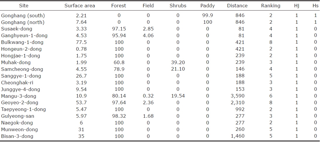
The nineteen biogeographical islands identified within the cadastral city of Seoul
-
[Table 2.] 
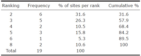
Ranking statistics for the analysis of optimal ecological conditions at nineteen sites within the city of Seoul