The Report of Comprehensive Assessment of Biodiversity in Japan (“Japan Biodiversity Outlook”) evaluated that the status of island ecosystems of Japan have suffered from major losses and long-term negative trends (Japan Biodiversity Outlook Science Committee 2010). It is known that natural elements of the islands are fragile to impact; it is considered that cultural elements are also fragile as well, since nature and culture are closely connected in the island system.
Concerning the importance of culture on biodiversity, the National Biodiversity Strategy of Japan 2012-2020, the Cabinet decision, indicates national target E-2-1 for Aichi-target as follows: “Reevaluate the wisdom on traditional knowledge and techniques for resource usage that have been cultivated in response to the natural characteristics of local regions, and strive to pass them down and promote their use.” And the strategy also describes a desirable future for the island areas in that “there will be ongoing efforts to create well-developed communities that nurture the distinctive nature and culture of the islands.”
Between Kyushu Island and Taiwan Island, in the southwestern area of Japan, there lay many islands such as Amamioshima Island, Okinawajima Island, Ishigakijima Island, Iriomotejima Island, and world heritage island Yakushima. These islands have distinguished nature and unique traditional cultures, and form a unique landscape. So these islands might be considered a region important to conserve world biodiversity and culture. However, various problems are arising on those islands.
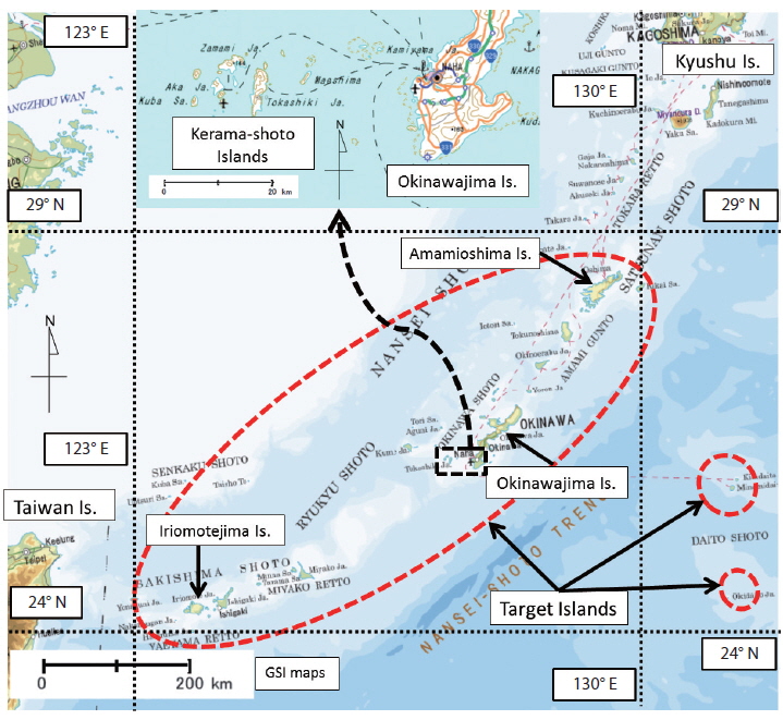
Targets of this report are the southern islands from Amamioshima Island since islands between Amamioshima Island and Kyushu Island are rather similar to Kyushu Island biologically and culturally. At first, this report introduces characteristics as well impacts of their nature and culture briefly. Then it introduces conservation efforts in brief. Since nature and culture are closely connected in the island system, comprehensive conservation both of nature and culture is essentially important, not only conservation of nature or culture independently. From this point of view, this report focuses on two comprehensive conservation efforts: both nature and culture. The first example is the effort to designate a new national park with the new concept of “environmental culture type” and “ecosystem management type” in the Amami Gunto Islands. This effort is a new challenge to focus on the importance of cultural aspects. The second example is the unique effort of the national park visitor center to conserve as one set of integrated nature and culture with an alliance of all stakeholders in Taketomijima Island, Iriomote- Ishigaki National Park. The visitor center serves not only visitors, but also islanders.
OVERVIEW OF ISLANDS OF SOUTHWESTERN JAPAN
>
Brief description of the region and target islands of this report
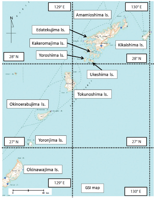
Japan has 341 islands 1 km2 or larger including the world’s seventh largest island, Honshu Island, according to the data of the Geographical Information Authority of Japan in 2009. Hereafter in this report, the number of islands means the number of islands 1 km2 or above. 72 islands lie from Taiwan Island to Kyushu Island over about 1000 km and are about North latitude 24 degrees to about 31 degrees. This region is one of the most concentrated island areas even in Japan, the islands country. These islands administratively belong to Kagoshima Prefecture and Okinawa Prefecture. Among these 72 islands, the 56 islands southward from Amamioshima Island are the targets of this report (Fig. 1). And among the 56 islands, there are 33 islands with the area of 5 km2 or larger. Table 1 shows the list of those 33 islands. 32 islands among them are inhabited. Among 23 islands that are between 1 km2 and 5 km2 in the area, 16 islands are inhabited. All islands are continental islands except the 3 islands: Minamidaitojima Island, Kitadaitojima Island, and Okidaitojima Island. These 3 islands are oceanic islands on the Philippine Sea plate. The total area of these 56 islands is 3,496 km2, less than 1% of Japanese territory. The total population is about 1,500,000 and about 1,260,000 people are living in the largest island, Okinawajima Island. The next largest populations are on Amamioshima Island, Ishigakijima Island, Miyakojima Island, and Tokunoshima Island with populations of 64,107, 46,922, 46,001, and 25,587, respectively. Iriomotejima is the third largest island, but its population is approximately 2000, which is relatively small.
[Table 1.] Outline of target islands (5 km2 or larger)
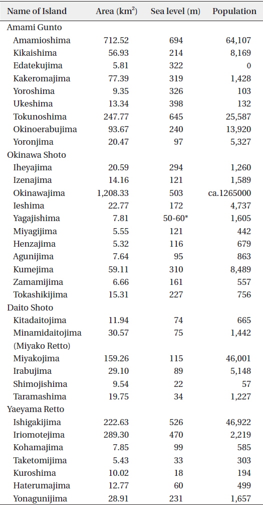
Outline of target islands (5 km2 or larger)
Climate is warm and humid, as it is influenced by the Asian monsoon. The annual mean temperatures and annual precipitation amounts are 21.8°C and 2837.7 mm in Naze, Amamioshima Island; 23.5°C and 2040.8 mm in Naha, Okinawajima Island; and 24.3°C and 2106.8 mm in Ishigaki, Ishigakijima Island. The Kuroshio Current flows near these islands and the monthly mean sea surface temperature is over 18°C in February (National Astronomical Observatory of Japan 2012).
Mezaki classifies islands into two types: “High Island” for those with mountains and “Low Island” for those with plateaus (Mezaki 1980). High Islands such as Amamioshima Island, Ishigakijima Island and Iriomotejima Island are accompanied by mountains, old sediment rocks, volcanic rocks and river systems. Low Islands, such as Yoronjima Island, Miyakojima Island and Taketomijima Island, have no mountains and are accompanied by Ryukyu limestone, Shimajiri mudstone layer formed in the Neogene period and groundwater system. Although there are 110 active volcanos defined by the Japan Meteorological Agency throughout Japan (Japan Meteorological Agency and Volcanological Society of Japan 2013), only one small island has an active volcano among the 56 islands and this active volcano exists undersea off the coast of Iriomotejima Island. On the other hand, 5 islands have active volcanos among the 16 islands between Amamioshima Island and Kyushu Island.
There are 2 national parks; Iriomote-Ishigaki National Park (hereafter NP) and the Kerama-shoto NP. The latter NP was newly designated on March 2013. And there are 3 quasi national parks: Amamigunto Quasi National Park (hereafter QNP), Okinawa-kaigan QNP and Okinawa senseki QNP. There is one nature conservation area: Sakiyamawan Bay at Iriomotejima Island. Nature conservation areas are outstanding nature areas and 10 areas are designated based on the Nature Conservation Law.
>
Characteristics and importance of the target islands
Characteristics and importance of the target islands are summarized as follows (1-6).
(1) Many endemic species, just like a melting pot of evolution, and (2) distinguished biodiversity due to its border around the bio-geographical region
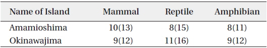
Since most target islands of this report lay on continental margin, there occurred sequences of connection and separation with the continent, so that invasion and speciation of many species cause many endemic species. Amamioshima Island and Okinawajima Island especially have many endemic species. Based on data of Ministry of the Environment of Japan (hereafter MOE), Table 2 shows the number of endemic species of mammals, reptiles and amphibians in Amamioshima Island and Okinawajima Island. Representative endemic species are the Amami rabbit (
[Table 2.] Number of endemic species in Amamioshima Island and Okinawajima Island

Number of endemic species in Amamioshima Island and Okinawajima Island
(3) Distinguished forest in Subtropical High zone, and (4) northernmost region of mangrove
Most areas in the same latitude are arid, as humidity and rich forest vegetation areas are rare in this part of world. There are abundant evergreen broad-leafed forests in Amamioshima Island, Tokunoshima Island, the northern part of Okinawajima Island and Iriomote Island. These forests are the main habitat of abundant fauna and flora. In Kyushu Island, there is a mangrove forest of
(5) Northernmost area of coral reef
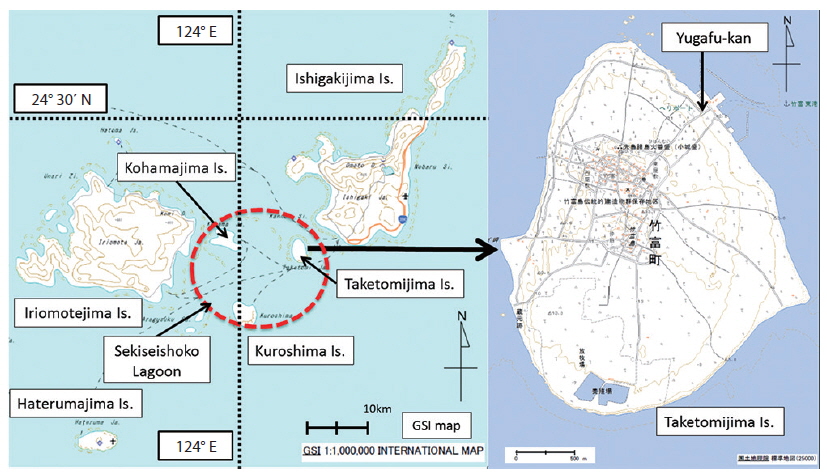
Most target islands are accompanied by coral reefs. Even though rather large size coral reefs are distributed around Yakushima Island and Tanegashima Island, in a broad sense, target islands are northernmost of coral reefs. The area around Ishigakijima Island and Iriomotejima Island is called Sekisei-shoko, a well-developed coral reef (Ministry of the Environment of Japan and Japanese Coral Reef Society 2004).
(6) Original culture integrated with nature is well conserved
The target islands have original and unique cultures and traditions integrated with nature. For example, Amamioshima Island has the “Arasatu” festival events, which are relevant to rice cultivation, and Taketomijima Island has the Tanatori harvest festival and so on. A characteristic traditional weaving and dyeing culture developed on the islands. There are diverse materials for threads, techniques for textiles and dyeing. For example, Oshima pongee of Amamioshima Island is designed with island motifs such as sea turtles, snakes, and plants and dyed with the native plant Sharinbai (
OUTLINE OF PROBLEMS AND COUNTERMEASURES
>
Threats of extinction of species
The threat of extinction of species including endemic species is one of the most severe problems. Based on data from Japan’s Red List (hereafter RL) of MOE in 2012 and 2013, 3,597 species are listed as endangered species (Ministry of the Environment of Japan 2012a, 2013a). Of the 356 vertebrates listed on the RL, 43 species inhabit Amamioshima Island, 0.2% of Japanese territory and 57 species inhabit Okinawajima Island, 0.3% of Japanese territory. The RL also suggested that 2 species of mammals and 6 species of bird had already become extinct in the target islands of this report. Concerning vascular plants, 1779 species are on the RL, and 108 and 146 species inhabit Amamioshima Island and Okinawajima Island, respectively.
Of those, 89 species are designated as national endangered species based on the Law for the Conservation of Endangered Species of Wild Fauna and Flora (Ministry of the Environment of Japan 2013b), and 28 of these species inhabit the target islands. Although national endangered species are prohibited to capture, there are species that need more vigorous measures. For such species, the government formulates and implement the plans for the conservation programs defined by the law. Conservation programs were planned and defined for 7 species such as the Okinawa rail and various measures are being implemented by relevant stakeholders including ex-situ conservation.
Habitat degradation is still a major factor affecting the risk of extinction though; invasive alien species are one of the most serious problems in target islands (Japan Biodiversity Outlook Science Committee 2010). Especially, the invasion of small Indian mongoose (
>
Degradation of the coral reef ecosystem
Degradation of the coral reef ecosystem is one of the grave problems. From 1972 to 2007, land increased by 31.55 km2 by a landfill, etc. in Okinawa Prefecture, which means the same area of coral reefs or tidal flats have disappeared. Red clay runoff causes strong impact to the coral reef ecosystem. And large–scale coral bleaching event in 1998 and 2007, as well as the outbreak of coral eating crown-of-thorns starfish (
>
Loss of knowledge and wisdom of nature
Yamada compared the knowledge of islanders about plant names in 1980 and 2005 in Haterumajima Island of Yaeyama Retto. Although the method of survey was slightly different, knowledge about plant names in 2005 was 50% to 75% of 1980 (Yamada 2012). This suggests the rapid loss of precious wisdom. The population of most target islands follows a trend of decline except for Okinawajima Island. It has thus become difficult to keep enough people to carry down traditional culture and relevant knowledge. The loss of knowledge on nature means the loss of ties between nature and human beings as well as the loss of the amount of intellectual property. An example of countermeasure on this issue in Taketomijima Island will be introduced later in this report.
>
Designation and expanding of conservation area
The first national parks in Japan were designated in 1934. Since then, national parks play an important role as the backbone of conservation of nature. However, new roles are expected because of the significant change of society as can be seen in the comprehensive review on designation and management of NPs and QNPs in 2007 (Ministry of the Environment of Japan 2007). Historically, the main goal for NPs had been great and splendor landscapes. But, in this review, new goals for landscape designation was suggested such as broad-leaved evergreen forests, coastal and oceanic areas, unique wetlands, etc. Based on this review, the MOE specified 18 candidate areas for new designation or large-scale expansion in 2010 (Ministry of the Environment of Japan 2010). As target islands of this report are less than 1% of the Japanese territory, there are 4 candidate areas. They are 1) Amami Gunto, 2) Yanbaru (northern area of Okinawajima Island), 3) Kerama-shoto (islands near Okinawajima Island) coastal areas and 4) Iriomotejima Island and its coastal waters (Fig. 4). Efforts for the designation of Amami gunto will be introduced later in this report. Kerama-shoto Islands, composed of Tokashikijima Island, Zamamijima Island and other small Islands, were designated as a new national park in March 2014. This new national park is unique for its large marine park area with almost all coastal water areas less than 30 m deep with beautiful coral reefs. And 7 km from the coast are ordinary zones of the national park where breeding humpback whales can be seen in winter. Efforts for the designation and expansion of national parks in Yanbaru (Okinawajima Island) and Iriomotejima Island have already been started.
TWO CASES OF CONSERVATION FOR SET OF NATURE AND CULTURE
In the islands, the integration of nature and culture is especially strong. Therefore, the conservation of the set of nature and culture is a key concept for the island region. Two cases, of the Amami Gunto Islands and Taketomijima Island, are introduced here.
>
Efforts for new concept of NP in Amami Gunto Islands
(1) Outline of Amami Gunto and background in brief
The Amami Gunto Islands are composed by eight inhabited islands and one uninhabited island, belonging to Kagoshima Prefecture. The southernmost island, Yoronjima Island, is only about 20 km away from the northern tip of Okinawajima Island (Fig. 2). The total area of islands bigger than 1 km2 is 1231 km2 and the total population is about 122,000. As mentioned above, a comprehensive review on NPs and QNPs was released in 2007 (Ministry of the Environment of Japan 2007). The review suggests that “Amami Gunto needs careful evaluation for designation as a national park.” So before the year 2010, the selection of 18 candidates for designation and large expansion of NPs and QNPs, consideration and discussion had already started about the concept for the new future NP of Amami Gunto Islands. The committee on conservation and use of natural resources of the Amami region was established in 2008. And the report on the basic concept of conservation and use of the natural resources of the Amami Gunto region was proposed to the public as the view of Naha nature conservation office of MOE (Naha Nature Conservation Office 2009).
(2) Basic concept of conservation and use of the natural resources of the Amami Gunto Islands
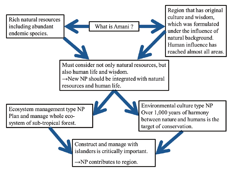
The outline of the basic concept is shown in Fig. 3. First of all, the discussion started with summarizing what the Amami region was and was summarized in the following two points: (i) The Amami Gunto Islands are a region with distinguished natural resources accompanied by many endemic species and a unique island ecosystem; and (ii) the Amami Gunto is a region where human life and a unique sense has been formed by the reflection of each island’s nature and where the influence of the harmony of nature and human life reach every corner of the island.
From those basic recognitions, the report of the Naha Nature Conservation Office (2009) explained “it is essential to consider not only natural resources themselves but human life and sense” and that the “NP of Amami Gunto region should be involved in the part of natural resources and human life.” Based on these recognitions, the report concludes that the basic concept of the future new national park should be an “ecosystem management type” and “environment culture type.” The concept of the ecosystem management type is as follows in brief: The target of conservation is the whole forest ecosystem and encouraging sustainable management measures not only include simple prohibition of forestry, but proper use of natural resources. The concept of environmental culture was first proposed in the Yakushima environmental culture village concept (Kagoshima Prefecture 1993). The concept is that the whole existence driven by historical processes and the consequence of relationships with nature and human beings. In other words, it is the whole acquired sense and lifestyle formed by the interaction of islanders and the nature of the island. The concept of environmental culture for the Amami region is as follows:
(i) Natural resources of the Amami region have been keeping strong interaction and harmony with human life and culture. Its interaction and harmony themselves are essential resources for the NP. Therefore, it is critically important to have a consensus to understand and conserve the whole harmony. (ii) Every island has its own original culture depending on differences of nature and historical background; this is the essential point of charm of these islands. Environmental culture typically remains in the Amami Gunto Islands region. (iii) Introducing the characteristics to visitors would increase the charm of the NP, and attract visitors to the new NP. The aim of the new NP is that both visitors and islanders can be blessed together and conserve not only nature, but also the culture of the Amami Gunto Islands.
Based on the basic concept, the desirable areas of the NP are subtropical evergreen deciduous forest with rich endemic species, etc., as well as representative traditional rural community landscape, and symbols of harmony with nature and culture. And the review of MOE in 2007 also pointed out that the new NP needed to pay careful attention to the four areas: ecosystem management, sustainable forest management of subtropical evergreen deciduous forests, integration of environment and culture, and promotion of sustainable use for tourism. Based on such basic concepts and policies, effort for the designation of a new national park is on its way. The main concept of the new national park, which is expected to be designated, is the integration of nature and culture. It should work as a model case for comprehensive conservation of the island’s nature and culture.
>
Effort of NP visitor center for cultural inheritance in Taketomijima Island
(1) Outline of Taketomijima Island
Taketomijima Island is a small and flat island located in the Sekisei-shoko lagoon, one of Japan’s largest coral reef seas, near Ishigakijima, 10 minutes by fast ship. Its circumference is about 9 km and area 5.4 km2 (Fig. 4). The population is approximately 350 people and its main industries are tourism and stockbreeding (Taketomi-town 2011). The entire island area is designated as Iriomote- Ishigaki National Park. There remains a historical village in the center of island, and its historical landscape is designated as an important preservation district for groups of traditional buildings under the Act on Protection of Cultural Properties. There is a famous traditional festival named Tanedori-sai, which is designated as an important intangible folk-cultural property of Japan, as well. Hence, Taketomijima Island is a well-conserved island with a set of natural landscape, cultural landscape and traditional culture. However, there is the problem of the declining population, which means the decrease of successors of traditional culture, loss of quality and quantity of traditional knowledge, etc. Concerning the decline of population, over 1000 people lived here before 1955, but now about 350 people inhabit the island (Taketomi-town 2011). And it is said that one third of the residents are immigrants. Immigrants contribute to sustain the population, however, few have knowledge of nature and traditional culture without learning.
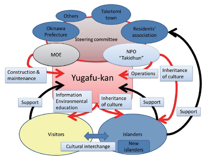
(2) Outline of the Yugafu-kan, NP visitor center and nonprofit organization Takidhun
The Yugafu-kan is a visitor center of Iriomote-Ishigaki NP. It is a 600 m2 one-story wooden building built in 2003 by the MOE and located near the opposite of the main port terminal of Taketomijima Island. Its objective is to provide information services to park visitors and mutual communication with visitors and islanders. It is open every day except during typhoons and admission is free. The name “Yugafu” means to receive various blessings of gods. Visitors to Yugafu-kan were 143,902 in F.Y. 2012 (Ministry of the Environment of Japan 2012c) out of a total of 388,903 visitors to Taketomijima Island (Taketomi-town 2014). The Yugafu-kan is in the top 10 of 54 visitor centers of the MOE. The Yugafu-kan is operated by the Taketomi Island Visitor Center Operating Committee, which is composed of national and local government and island stakeholders, and managed by the non-profit organization Takidhun under a contract. The non-profit organization (hereafter, NPO), Takidhun, was founded in 2002. Takidhun means Taketomijima Island in the island dialect. Its objective is passing on cultural heritage and the natural environment to future generations and contributing to communities’ development. The NPO received accreditation from the MOE as a park management body based on the Natural Parks Act in 2009. Tasks as park management body includes the implementation of study programs about nature trails, maintenance of trails, the natural environment, the community’s landscape, etc. And conservation and research of important cultural heritage is a task of the NPO.
(3) Outline of activities and its characteristics
The Yugafu-kan has many useful exhibitions such as a panel of nature and culture on Taketomijima Island and Iriomote-Ishigaki NP, textile craftwork, traditional tools, etc. Visitors can watch a video named Ori-tori Takidhun (welcome to Taketomijima Island in island dialect), that is a useful tool to understand the culture and nature of the island. The exhibitions contain records of actual sounds of songs, old tales, and religious rituals, etc., including items only of oral instruction. It is useful tool for islanders to hand down traditions orally over the generations. Yugafukan implements extensive activities, with the cooperation of the NPO and relevant groups. Examples of activities are as follows: study tours of the island’s heritage for visitors and islanders, study meetings focused on biodiversity of Taketomijima Island for visitors, lectures on the island’s religious rites and festivals for visitors, traditional tool making workshops for islander, etc. The unique activity, “Oba guide” refers to elderly islander women (“Oba”), who were born and lived with traditional wisdom, serving as guides. They introduce “real” life, which cannot be explained by exhibits alone. Generally, the NP visitor center is defined as a facility for activity of interpretation and/or for exhibitions for visitors to understand nature, history of the park, etc. The objectives of the Yugafu-kan is to explain the nature and culture of the park, raise public awareness of nature conservation and provide park information. The Yugafu-kan also has the objectives mentioned above, but the unique point of the Yugafu-kan is that it has the additional objectives and functions as follows (Fig. 5):
(i) Targets of activity are not only visitors, but also islanders. (ii) It has the function of a culture inheritance center for islanders, not only a simple information center for visitors. (iii) Its exhibition and activities strongly focus on culture and island tradition.
To cope with the decline of population, measures such as economic incentives are needed. However the Yugafukan contributes to the community to sustain the quality and quantity islanders’ wisdom, which can also contribute to keep the high quality of the NP. It is considered to give an important suggestion on function of the visitor center as a good model.
Southwestern islands of Japan, which lie between Kyushu Island and Taiwan Island, are important both biologically and culturally. The target islands of this report, making up less than 1% of Japanese land, is one of the essential centers of biodiversity and culture. Distinguished nature and culture still remains in the islands, but this heritage is declining rapidly. Hence, conservation measures need to be taken. There is no doubt that there are many negative impacts on nature and culture. Therefore, urgent individual countermeasures should be taken such as eradication of Mongoose, protection of endangered species, restoration of coral reef ecosystems, etc. However, since nature and culture are strongly integrated in the island system, conservation of a set of nature and culture is a key concept for the islands. Conservation of a set of nature and culture means conservation of the landscape of the island and this is an important task of the NP.
Designation of the NP will not solve all problems automatically, but it is a useful tool as the foundation of conservation. Saving the NP and other conservation areas is of utmost importance in those islands and intensive efforts are underway. Two cases concerning the NP for conservation of a set of nature and culture are introduced: the case of Amami Gunto Islands, the effort for designation of a NP from a new point of view, whose main target of conservation is the integration of nature and culture; and in case of Taketomijima Island, it is a model case where the national park facility, the visitor center Yugafu-kan works for conservation and succession of traditional knowledge of the island.
Integration of nature and culture are weakening and wisdoms concerning nature are rapidly disappearing, especially on the main island of Japan. But those heritages still remain in some remote islands. These two cases are good models that give some hints for future conservation measures of remote islands as well as the main land of Japan.