We have focused on a process of consensus building among islanders, scientists and national government officers in the Yakushima Biosphere Reserve. Island ecosystems are isolated. There are many endemic taxa. Island ecosystems are vulnerable to human impact, typically due to invasive species. An island’s natural capital and resources are utilized according to traditional and local island culture. Islands often maintain more traditional culture than the mainland. The usage of ecosystem services often differs between human communities. Biological diversity is strongly linked with cultural diversity. Biocultural diversity is defined as the diversity of life in all its manifestations: biological, cultural, and linguistic (Maffi 2001). Attention to the relationships between biological and cultural diversity are increasing (Loh and Harmon 2005).
To enhance such island activities in biocultural diversity, the United Nations Educational, Scientific and Cultural Organization’s (UNESCO) Man and the Biosphere (MAB) Program initiated the World Network of Island and Coastal Biosphere Reserves (WNIBR). Biosphere reserves (BRs) is one of the projects initiated by the MAB Program. BRs are nominated by the national committee for UNESCO. The International Advisory Committee for Biosphere Reserve (IACBR) reviews each nomination and recommends either an approval, defer, or reject (UNESCO 2012). After recommended by the IACBR, the MAB International Coordinating Committee (MAB-ICC) has made the final decision every year. The MAB-ICC consists of 34 member states as of 2014 (UNESCO 2013).
In this paper, we introduce the processes of consensus building in the extension plan of Yakushima BR and deer management on Yakushima Island. In both processes, scientific investigations of feasibility studies were very important.
>
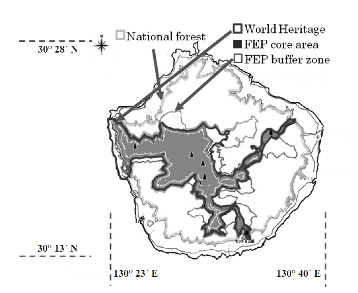
Zoning of 4 kinds of nature reserves on Yakushima Island
There are several protected areas on Yakushima Island, defined either nationally or globally. Forest Agency, Japan (FAJ) defined the forest ecosystem protected (FEP) area on Yakushima in 1992 (Fig. 1). The Ministry of the Environment of Japan (MoE) defined the national park (NP) in 1964, the wilderness area in 1975, and the marine reserves in 2002 on Yakushima (Okano and Matsuda 2013). Yakushima was also designated as a biosphere reserve (BR) in 1980 (Fig. 2), and registered as natural world heritage (WH) in 1993 (Fig. 1). Nagata-hama beach, one of the most important breeding sites of loggerhead turtle (
>
Paper parks and top-down management on Yakushima Island
Although many kinds of nature reserves exist on Yakushima, Yakushima residents’ attitudes toward nature is still unclear. This is probably because management bodies of these reserves are national government officers. The FEP areas, WHs and Ramsar sites, and the hunting-ban areas are managed by the FAJ, the MoE, and the prefectural governments, respectively. The management office of the Yakushima BR is officially the national park ranger office, but the BR was not being effectively managed until 2012, even though the meeting of the East Asian Biosphere Reserve Network was held in Yakushima in 1997.
The IACBR and the MAB-ICC strongly recommend that the core area be surrounded by a buffer zone. On the other side, both the Ramsar Convention and the MAB Program encourage a participatory approach (Stoll-Kleemann and Welp 2008, Tanaka T, unpublished) and a soft law that does not protect the buffer zones by law. In the case of Yakushima, the MoE determined that the Ramsar site zone was not surrounded by a buffer zone, because most of the adjacent areas were private properties of approximately 40 personal owners. In the case of the Nagata-hama Ramsar site on Yakushima, three beaches are the second rank special areas of Japanese nature park law, and are not surrounded by buffer zones on the land side at all. Two of the three beaches (Yotsuse-hama and Maehama) are surrounded by a regular zone of NP on the marine side, while the other beach (Inaka-hama) is adjacent to Nagata-hama Port. The Nagatahama Sea Turtle Conservation Association, organized by the MoE, introduced a set of rules to keep visitors from disturbing spawning sea turtles on this beach in 2009, which require visitors to join tour groups guided by the local community, and to refrain from using cameras and video equipment (Okano and Matsuda 2013). These voluntary rules probably help nature conservation on the Ramsar site.
>
Characteristics of Yakushima and Kuchinorabujima Biosphere Reserve
Flora of Yakushima is characterized by (1) vertical distribution of the vegetation from the subtropical zone to the subalpine zone (Tagawa 1995), and (2) rich biodiversity including many endemic plant species or subspecies supported by heavy rain owing to one of the largest warm currents, “Kuroshio” (Okano and Matsuda 2013). In that report, it has also been reported that there are about 1,500 plant species with many endemic species, and that Yakushima is both the northern and southern limit of some plant species. Also, the average rainfall in lowland areas is 4,000 mm/yr and 8,000-10,000 mm/yr in mountain areas (Okano and Matsuda 2013).
Kuchinoerabujima Island has a volcano and hot spas. All land areas are part of the NP, and are fully surrounded by the NP, including marine parks. There are approximately 135 residents on the island as of 2014. This island, which was not included in the WH area inscribed in 1997, was included in Yakushima NP in 2009 (Association for Yakushima and Kuchinoerabujima Biosphere Reserve 2014).
The Japanese National Committee for MAB calls the BR as the “UNESCO Ecopark” and encourages the theme of each BR, which indicates characteristics of the BR. The Association for Yakushima and Kuchinoerabujima Biosphere Reserve (2014) agreed on its theme as “The islands of volcano and water connecting with the Kuroshio Current: human and nature ecopark.”
>
Deer management on Yakushima Island
In many Japanese national parks, there have been controversies regarding deer management. Deer populations have been threatened from the early 20th century. Deer have been well protected through measures such as hunting bans throughout Japan. On Hokkaido Island, deer hunting was banned during 1884-1956, except for the period of 1907-1911 (Kaji et al. 2010). In Shiretoko, in the WH belonging to eastern Hokkaido, local stakeholders agreed that they would watch the natural succession process of Shiretoko in 1997 (Kaji et al. 2010). The deer management plan was enforced in eastern Hokkaido. Under the recommendation by the Scientific Committee for Shiretoko WH, the local stakeholders agreed to introduce a population control plan into Shiretoko WH in 2006 (Kaji et al. 2010). The data of regeneration success of seedling trees reforested by citizens and the municipality of Shari town showed very low survival rate of seedlings, because they were eaten by deer (Kaji et al. 2010). Reasons for the overabundance of deer in Japan are (1) the long-term hunting regulation until the end of the 20th century, (2) land use change from forests to grasslands and agricultural farms, and (3) the extinction of Japanese wolves (
In contrast to Shiretoko, scientists disagree to the population control of deer on Yakushima Island. A statement against deer population control in the west (World Heritage) area of Yakushima by 19 scientists in December 2011 read, “The west area of Yakushima WH should be under natural succession without any human actions. Deer population control is not appropriate there....(Agetsuma 2012).” Many scientists and ecologists including islanders hesitated to cull deer in the world heritage site.
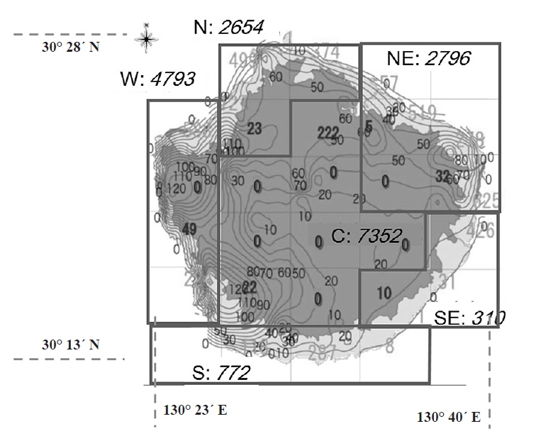
Until 2008, the catch of deer was about 300 every year (Kagoshima Prefecture 2013). Kagoshima Prefecture has enforced the Population Management Plan for Yaku Deer since 2011 (Kagoshima Prefecture 2013). Yakushima Island was divided into 6 management zones: central (C), south-eastern (SE), north-eastern (NE), northern (N), western (W), and southern (S) zones (Fig. 3). A major part of the Yakushima WH area is included in the western, central, and north-eastern zones. The catch increased drastically from 500 in 2009 to 4500 in 2012 and 2013 (Fujimaki et al., unpublished). However, there seemed to be no significant decrease in the deer population. The number of deer on Yakushima Island is estimated to be 31,650 (23,217-40,083 for a 95% confidence interval) in 2012 (Kagoshima Prefecture 2013). The natural population growth rate is probably 10-15% per year (Kagoshima Prefecture 2013). We need to increase the catch amount to control the deer population by culling. Among the 6 management zones, we need a substantial increase of catch in the central zone (Fig. 3). The central zone is managed mainly by the Forest Agency and game hunters were discouraged to enter the national forest for hunting or culling (Okano and Matsuda 2013). In addition, the population size is still underestimated and the migration between management zones is not negligible in some management zones. For example, the sum of catch (468) was larger than the estimated population size (310) in the south-eastern zone (Kagoshima Prefecture 2013). There have been several methods of wildlife population estimation. On Yakushima Island, a fecal pellet count method was used in the estimation of the deer population size (Kagoshima Prefecture 2013). The population size was independently estimated by data collected each year. More recently, the population is often estimated by a “state-space model” (Buckland et al. 2004, Yamamura et al. 2008), which includes two equations: a state equation and an observation equation. The state equation describes the population dynamics with harvest, while the observation equation describes the relationship between the observed population and the true population. “State-space models” estimate observation errors and process uncertainty in order to fit the long-term population estimation obtained by a fecal pellet count method.
Controversy on deer culling still exists among islanders and other stakeholders. In order to strengthen the communication between visiting scientists and islanders, the Society of Yakushimaology was established on December 14-15, 2013. About 200 scientists and islanders participated in the first meeting (Yumoto 2014). This may be a good place for consensus building in deer management and other wildlife issues.
The review process of world natural heritage does not positively evaluate sustainable use. Periodic reports on the implementation of the world natural heritage include no checklists for sustainable use or the local economy (UNESCO). There is some conflict between protectionism and conservationism in nature reserves (Nash 1990).
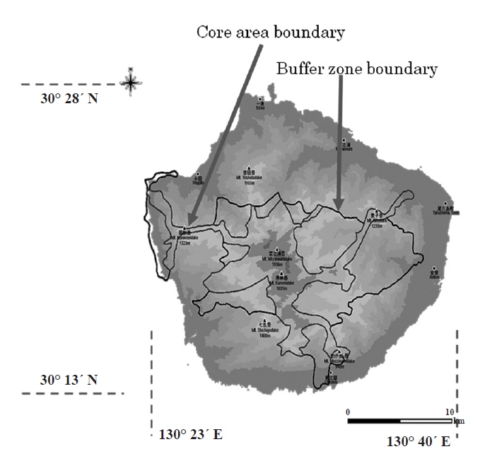
Yakushima Island has a local project, which adopts a similar idea to biocultural diversity (Hong 2013, Hong et al. 2013). “The Yakushima Environmental Culture Village” program enhances the maintenance of the local ecological knowledge on the island. This concept has a zoning plan, which consists of three zones similar to BRs (Okano and Matsuda 2013). The extension plan of the BR (Fig. 4) is based on the idea of the “Yakushima Environmental Culture Village” (Association for Yakushima and Kuchinoerabujima Biosphere Reserve 2014).
A participatory approach in local environmental management is important in both BRs and Ramsar sites. Nationwide networks for BRs and Ramsar sites are effective for collaboration among local stakeholders or co-management. Co-management means a management blending top-down regulations and bottom-up management by stakeholders (Makino and Matsuda 2005). International, regional, and specific networks for BRs are very effective for the improvement of BR activities, the World Network of BRs (WNBR), the East-Asian BR network (EABRN), the World Network of Island and Coastal BRs (WNIBR), and others. In 2012, the Japan Biosphere Reserves Network (JBRnet) was established to enhance electronic communication between local stakeholders of Japanese BRs (Matsuda and Sakai 2015). The first meeting of J-BRnet was held in Tadami town from October 25-26, 2013, although Tadami BR had not yet been designated by the MAB-ICC (Matsuda and Sakai 2015). Local stakeholders of BRs realized the importance of communication between the BRs, as it is indispensable for a participatory approach.
There was controversy between NP rangers and municipality officers. The former requested to include the Ramsar site into the core area of the BR, while the latter wished to include the Ramsar site as a buffer zone (Association for Yakushima and Kuchinoerabujima Biosphere Reserve 2014). There are no formal authorities of the management in land use of the surrounded area because there are >30 owners of private properties (Association for Yakushima and Kuchinoerabujima Biosphere Reserve 2014). The nomination form of the biosphere reserve needs signatures of all management authorities of the core area and buffer zone. We agreed that it was quite difficult to make buffer zones that surround the Ramsar site.