For a long while, the Mars has been an object of attention and many studies have been conducted due to its environmental similarity with the Earth. The ultimate purpose of the Mars exploration was to find out the possibilities if man can land on and explore the Mars; and furthermore, man can move to the Mars and make an extended stay.
The subjects of research on the Mars exploration had two kinds. One was direct exploration which lander and rover lands and processes, and the other was indirect exploration which terrestrial and space telescope is utilized. Direct exploration studies on geographical features and its formation and evolution, analysis of soil ingredients of grounds and its evolution, studies on the atmosphere and weather in a local space area, and existence of creatures and its possibilities. Meanwhile, indirect exploration includes global studies on the atmosphere and weather on the Mars.
When planning exploration with landing landers and rovers on the Mars, selection of a landing site is very crucial matter. With setting scientific goals for the Mars exploration beforehand, corresponding landing site must be selected, and the geography of a selected site also should provide a stable landing and traveling for the machines like landers and rovers. In this paper, selection of a landing site for scientific goals was discussed with the scientific missions of previous Mars probes (Sections 1 and 2). It also discussed scientific values of previous landing zones (Section 2), and introduced the research trends on the Mars. Lastly, this paper examined issues of selecting a landing site when sending Mars probes to the Mars by our own efforts in the future based on these present researches (Section 3).
The Mars, 1/2 radius of the Earth, is seen red from the Earth since the soils contained a high level of iron oxide on the surface. The duration of day and night time is similar to one with the Earth. However, low gravity and less air of the Mars make it difficult to stay as liquid state for water. The planet of Mars with some similar and different characteristics of the Earth became an important object for scientists to find out the huge goal of human-habitability, and continue the exploration. The geographical features of the Mars are important subject for scientific explorations as well as safe landing.
The Mars has impact topography, volcano, tectonic sites, and caves. The geographic features of the Mars are divided into two; northern area flattens by lava and southern
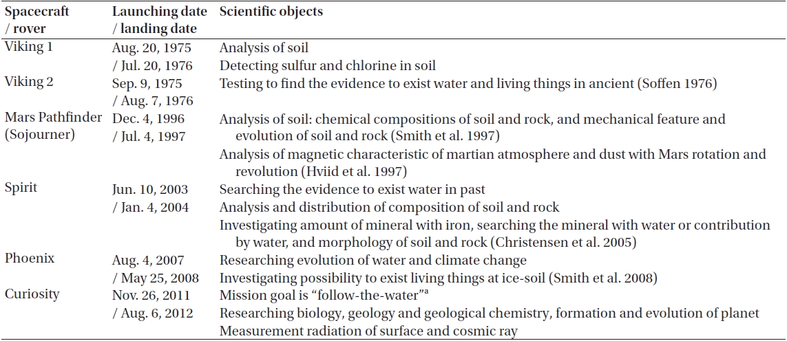
[Table 1.] Exploration probe for Mars and scientific objects.

Exploration probe for Mars and scientific objects.
highland with a lot of traces for impacts. In the southern hemisphere, about 4,300 of craters sized above 5 km are discovered. Of these, Hellas impact basin is observable at the visible area from the Earth. Tharsis area distributed near the equator in west of the Mars is featured by several volcanoes with different formation times. Olympus Mons on the Mars, the largest volcano in our Solar System is the most recent volcano in this region. Moreover, the traces of erupted lava from these volcanoes featured long from the South to the North, and it is assumed that the volcanic activities have affected the martian atmosphere (Solomon et al. 2005).
Valles Marineris was known that it was formed by a reverse fault, but recent studies discovered that Valles Marineries were formed by plates crash. In addition, it was suggested that the Mars is formed with two enormous plates (Wolpert 2012).
One of the recent studies on lunar exploration was exploration of caves. The purpose of the exploration is to secure a safe place for high energy particles, UV light, spacecrafts, fine meteorites from the universe and the Sun while man stays a period of time for lunar exploration. It is continued to the studies on the Mars. These caves located at the side of Arsia Mons have been explored with scientific purposes to explore the inner part of the Mars, to determine the formation and evolution of caves and the different with Earth's ones, and to find out the human-habitability in the caves (Edberg 2012).
There are polar caps which were made with condenses of carbon dioxide from the atmosphere of the Mars in the South and North Pole of the Mars. The size of a polar cap changes from season to season depend on distribution of dust, vapor, and frost in the atmosphere or sky coverage ranged in Polar Regions. In fact, when Opportunity landed in 2004, the photos of water-ice cloud were taken.
The main components of soils in the Mars are magnesium, sodium, potassium, chlorine, etc which essential ingredients for plants to grow are. The soils of the Mars have pH of 8.3, weak Alkaline, and also contain elements of salts (Morrison & Owen 1988).
1.2 Lander and Rover for the Mars
When the program is planned for exploration of celestial body, general scientific questions are asked, and we try to find the answers and discuss the validity of the solutions; 1) whether the Mars probe is able to complete the mission within exploration sites, that is, the technological possibilities exist. 2) After exploration, the technology can contribute the development of new technology, and 3) whether scientific purpose and the technological limits are harmonized (Greeley 1990). After exploration planning is completed with the discussions above, the scientific goals for the Mars exploration are set up. The recent scientific goals on the Mars exploration are: the time that the atmosphere of Mars maintained the current density, formation time and evolution of the core and surface of Mars, studies on chemical and geographical features of surfaces by water, time of erosion, transport, sedimentation of soils, evidences and conditions for existence of living things. Under these scientific goals, Table 1 described the detailed missions of each Mars probes.
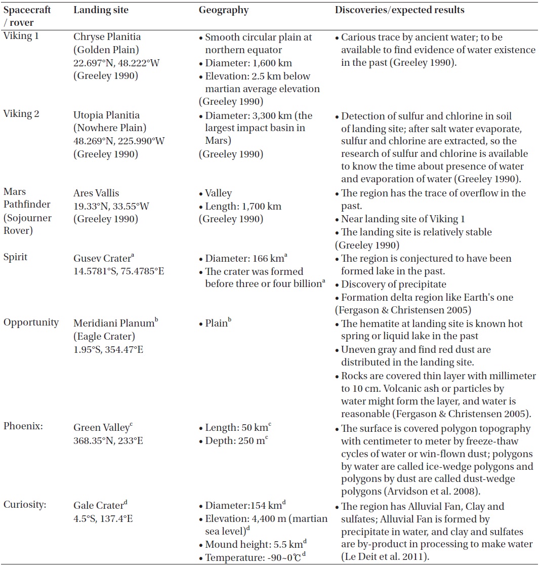
[Table 2.] List landers or rovers for Mars, landing sites and scientific features.

List landers or rovers for Mars, landing sites and scientific features.
2. THE FEATURES OF LANDING SITES
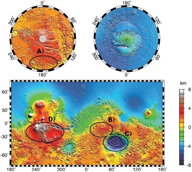
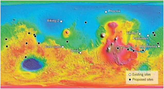
The Mars probe has landed in a corresponding landing site with a certain scientific mission. Fig. 1 describes the landing sites of Mars probes in the past on the map (white dots), and the black dots indicate the possible landing site currently considered as most suitable zones in the future. Table 2 summarizes the locations of landing sites from each Mars probes, its geographical features and scientific values. As described in Table 2 on characters of a landing site, the main scientific purpose of Mars probe is to explore the traces of water existences and the possibilities of water
existence.
The ultimate goal of Mars exploration is to find the traces of living things and the possibilities of existence of lives. Therefore, the fact whether water exists in Mars or not are expected to provide answers for existence of living things.
Recently, soon after Curiosity at the Mars Science Laboratory (MSL) selected a landing site for Mars probe, space scientists provided their own opinions competitively on selection of a landing site. Fig. 1 shows the proposed sites for following Mars probe provided by multiple scientists after Gale Crater was selected for Curiosity’s landing site. The most important goal for Mars scientists chosen these proposed sites is to find the evidence for water that contains the evidence for ancient life. And another goal is to find igneous rock that determines the age of Mars. As a landing site that corresponding these two goals, sites in Fig. 1 are considered (Hand 2012).
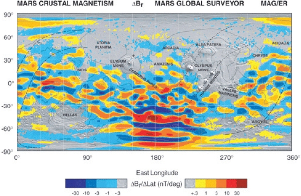
In this paper, our research team marked the spots with oval shape in Fig. 2 with consideration of exploration time and based on the research subjects on Mars.
A) In spot A, high Mars magnetic field is measured which is the spot necessary data for research on ionization layer of Mars can be retained. Fig. 3 contains the data from orbiter, the Mars Global Surveyors. Itthe high magnetic
field appears at longitude 180 degree with 60°~90°S latitude.
Retained data after installation of a measuring instrument in the spot that high magnetic field appeared can be useful to find out the changes of Mars Ionosphere by time and changes by active sun.
Moreover, it also can collect the distribution of vertical temperature in this spot, which is polar region. And it is expected that the result appear different from the one at middle latitude.
B) Spot B was named as “Terra Sabaea”, and unlike other landing sites, Mars probe can explore a wide-ranging highland. Previously, geographical features of landing sites and exploration sites contained volcano areas or craters, and Mars probe explored following the trace of water. Meanwhile, spot B does not have geographical features, data on components of atmosphere and distributions, and temperature measured from the spot can be comparable data that can be compared with other regions.
Comparison analysis on changes in data by time measured in this spot with data measured from the Mars overall is expected to provide the possible progress on a study of motion of the atmosphere and the weather of Mars.
C) Spot C is a crater named as “Hellas Bassin”, which is enormous impact topography with 2,300 km in diameter, a depth of 7,000 m (from the standard height of Mars). The pressures of the atmosphere from the ground is 11.55 mbar (The Mars’ topographical datum: 6.1 mbar), and water can be exist in a form of liquid with this value and the temperature of spot. Some argues that in the deep valley at inner part of crater, water can coexist as a form of ice and vapor (Kawaguch et al. 2008).
D) Spot D is Tharsis region where Olympus Mons volcano is located. This spot is higher than the other sites due to lava from volcano eruption. There is a high possibility that
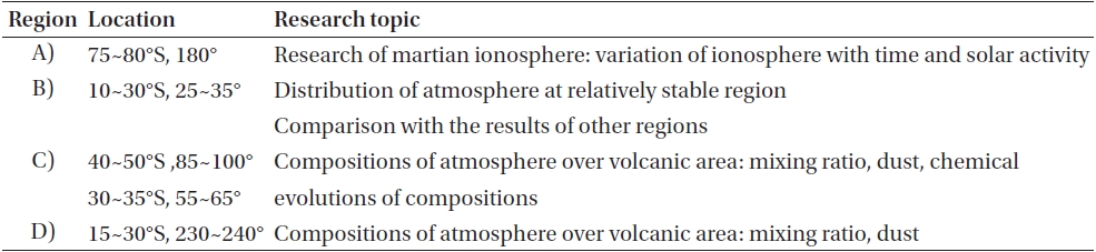
[Table 3.] Candidate regions in this work, and available research topics.

Candidate regions in this work, and available research topics.
the existing geography was transformed by erosion of lava. And the atmosphere of Mars seems to take a different path with other regions affected by volcano gas from its eruption. When safe landing is not applicable due to its highland, a impactor can measure the atmosphere while colliding body is dropped and descending.
Table 3 summarizes the fields of studies that can be done by data collected from the proposed spots in this paper. Observation methods in proposed landing sites would be considered such as installation of measurement equipment on the ground, and launching balloon for measurement from lander after landing. Moreover, the proposed landing site will be meaningful if exploration can be conducted not only by landing but also by impactors, or orbiters.
Currently, domestic research on Mars conducted contains few subjects and areas. A study on principle of geographical formation and form of Mars was conducted by using the data collected from the Mars probes in the past (Lee 2012), and a study on topographic map that describes a certain geographical features of Mars. Moreover, a study exploring caves in Mars with the image data taken by the orbiter for Mars is in progress for the purpose as described above (Section 1.1).
Our research team also has been conducting a study on Mars. Unlike the Earth, the Mars has no magnetic field itself, topside of an ionization layer of Mars is exposed to solar wind, and loss of the atmosphere and magnetic field that exists partially on the ground because it was swept by solar wind. This study focuses on these magnetic fields. Currently, our team concentrates on the relations of secondary or additional layer that is topside of M1 of an ionization layer with solar activities and magnetic field on the ground by using data from Mars Advanced Radar for Subsurface and Ionospheric Sounding topside sounder, loaded at the Mars Express.
Another area the author working on is a joint research with Max Planck Institute for Solar System Research, using atmospheric data of Mars from Herschel space telescope. At present, a study on H2O, CO distribution in the martian atmosphere is carried out by applying the data from Herschel space telescope (Swinyard et al. 2010), and a study on the atmosphere using H2O2, HCl, O2 is on progress (Hartogh et al. 2010a,b). Later, a study on water and methane with a spectrum analysis of the martian atmosphere explored by Herschel is planned. Water and methane were chosen because they have significances that suggests the possibility of existing living things. According to Geminale et al. (2008), carbon dioxide, that composes most of the martian atmosphere, and hydrogen swept by solar wind can create water and methane. He also argued that with the spectrum analysis, it might be possible to trace the living things from the existence of water and methane in certain spots.
4H2+CO2=CH4+2H2O
Moreover, by researching on component parts of the atmosphere of the Mars, vertical and horizontal distribution and its variation with time, and vertical and horizontal temperature and its variation with time, chemical reaction of the atmosphere of Mars by atmospheric dynamics and sunlight can be studied. With the result of these studies, studies on the characters of climate and weather forecast of Mars can be conducted. This result also helps to predict the weather in Mars at the time of landing site selection and contributes to selecting a more stable time and spot for landing.
In this respect, the matter of a landing zone selection has values as a study subject that encompasses the subject of geology, meteorology, and environmentology. And it is expected to be a core project that combines different research interests into one united goal. Moreover, when planning Mars probe with domestic technology in the future, these multidisciplinary research groups will become an epicenter for setting a scientific goal, exploration sites and a landing site.