A coastal sand dune is an ecosystem distributed around the world. It is an ecological ecotone, where the features of coastal areas and the geographical, ecological features of land areas are both shown (Carter 1988, van der Maarel 2003, Walker et al. 2003). Endemic species forming a unique biota, different from the two ecosystems, frequently inhabit a coastal sand dune. In particular, many halophytes or sand dune plants ensuring high salt resistance grow in sand dunes; thus, unique sand dune vegetation, different from that of land vegetation, is formed (Kim et al. 1987, Kim and Ihm 1988). Since sand dune vegetation secures sand from sand beaches, prevents sand dunes from being eroded, and maintains scenery on coasts, its value for preservation is very high (Ministry of Environment 2001). These coastal sand dunes are very sensitive to external influences. Such external forces include coastal erosion and destruction of sand dune vegetation, topography due to unplanned development or immoderate sightseeing, and the destruction of coastal ecosystems due to the pollution of coastal sea areas. Under these external influences, coastal ecosystems are losing the unique features of coastal sand dune vegetation due to the introduction of naturalized plants and introduced species. In a broad sense, exotic species and naturalized plants are defined as invasive plants that invade a new environment after coming out of their habitats. Several reasons explain for the invasion such as competition with native plants and adaptation to the environment and includes cultivated plants which come out of their plantations and go wild (Kim et al. 2008). In urban areas, a variety of naturalized plants are appearing in nearly any and all biotope types due to the continued interference of human beings and the diversification of land use (Choi et al. 2009). In the ecosystem of coastal sand dunes, land use is being diversified due to artificial interference. In aspect to the land use, the concept of biotope was introduced. Biotope was first introduced by Dahl (1908), a biologist of Germany, in 1908. Dahl had further developed the concept of biological community, which was conceived by Moebius in 1877. Commonly, a habitat is used in the same meaning as a biotope. Most of the German scholars, who have developed the concept of biotope, limit habitat to “a habitation space for one species or population,” and define biotope by linking it with biological communities (Leser 1991). Biotopes have been used extensively during the last decade as a tool for managers in relation to the classification of coastal zones and marine areas (Ducrotoy 2010).
In this paper, biotope types in the ecosystem of coastal sand dunes are classified. In addition, the validity of the urbanization index, as an index for the assessment of preservation value, is analyzed. Methods for the selection of assessment indices for the ecosystem of coastal sand dunes have rarely been known. In the paper written by Seo (2008), indices for the value assessment of coastal sand dunes were developed. The indices were categorized into scale and dynamics for the assessment of inorganic environmental value of coastal sand dunes, diversity, naturalness, and ecosystem maps. This categorization was conducted for the assessment of organic environmental value of coastal sand dunes, scarcity and scientific value equivalent to that of the human, and the social value of coastal sand dunes. Besides these indices, other assessment indices are unknown. The value or influence of the ecosystem of coastal sand dunes has not been assessed properly, and moreover, the ecosystem has been developed immoderately. As a result, the ecosystem, biological diversity, as well as scenery have been destructed. However, appropriate action has not been taken.
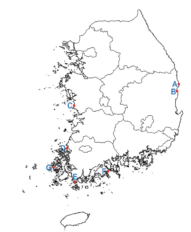
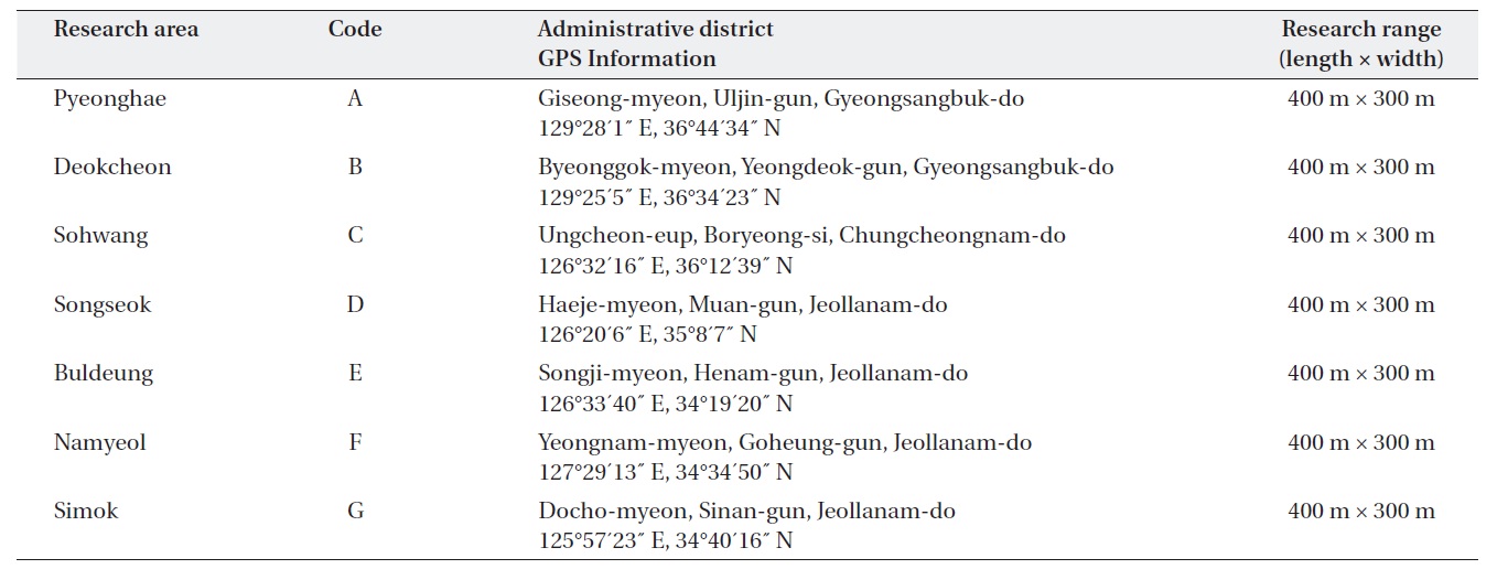
Six coastal sand dunes were selected from each of the eastern, western, and southern coasts of the Korean Peninsula for our research areas. Simok coastal sand dune, which is on an island, was additionally selected (Fig. 1).
To evaluate the uniformity, the range of the research areas includes 120,000 m2 of coastal sand dunes. A length and width of 400 m × 300 m was set as the area for our research (Table 1). In order to research the vegetation and biotope types of the coastal sand dunes, research areas, along with the ranges, were selected.
The types of biotype in each research area were classified, and floras were examined by biotope types. Biotope classification means that all similar biotopes are reviewed, made into an abstract concept, and classified. This definition comes from a realistic point of view where it is easy to assess biotopes in an open field and thus, classification can be performed (Blab 1993). Therefore, biotope classification denotes the classification of biotopes with similar characteristics after reviewing biotopes in the target areas. First, a vegetation map was drawn and classified depending on habitats. Based on the classified vegetation map, biotope types were classified the drawing was completed with Auto Cad. In the summer, when plants are rich in the number of plants, the flora of each biotope type was examined. The flora was categorized into vascular plants, halophytes, and naturalized plants. The flora of each biotope type was classify the naturalized plants based on the colored illustrations of naturalized plants of Korea (Park 1995, 2001) and the naturalized plants in Korea (Kim et al. 2000).
In order to analyze the naturalization rate and urban-
[Table 1.] Research areas and range of geographic information
Research areas and range of geographic information
ization index of each biotope type in each research area, the formulae below were used:
PN (%) = S/N × 100
PN: naturalization rate
N: number of plant species growing in an area
S: number of naturalized plant species
UI (%) = S/N × 100
UI: urbanization index
N: total number of naturalized plant species distributed in Korea (N = 267)
S: number of naturalized plant species in the research areas
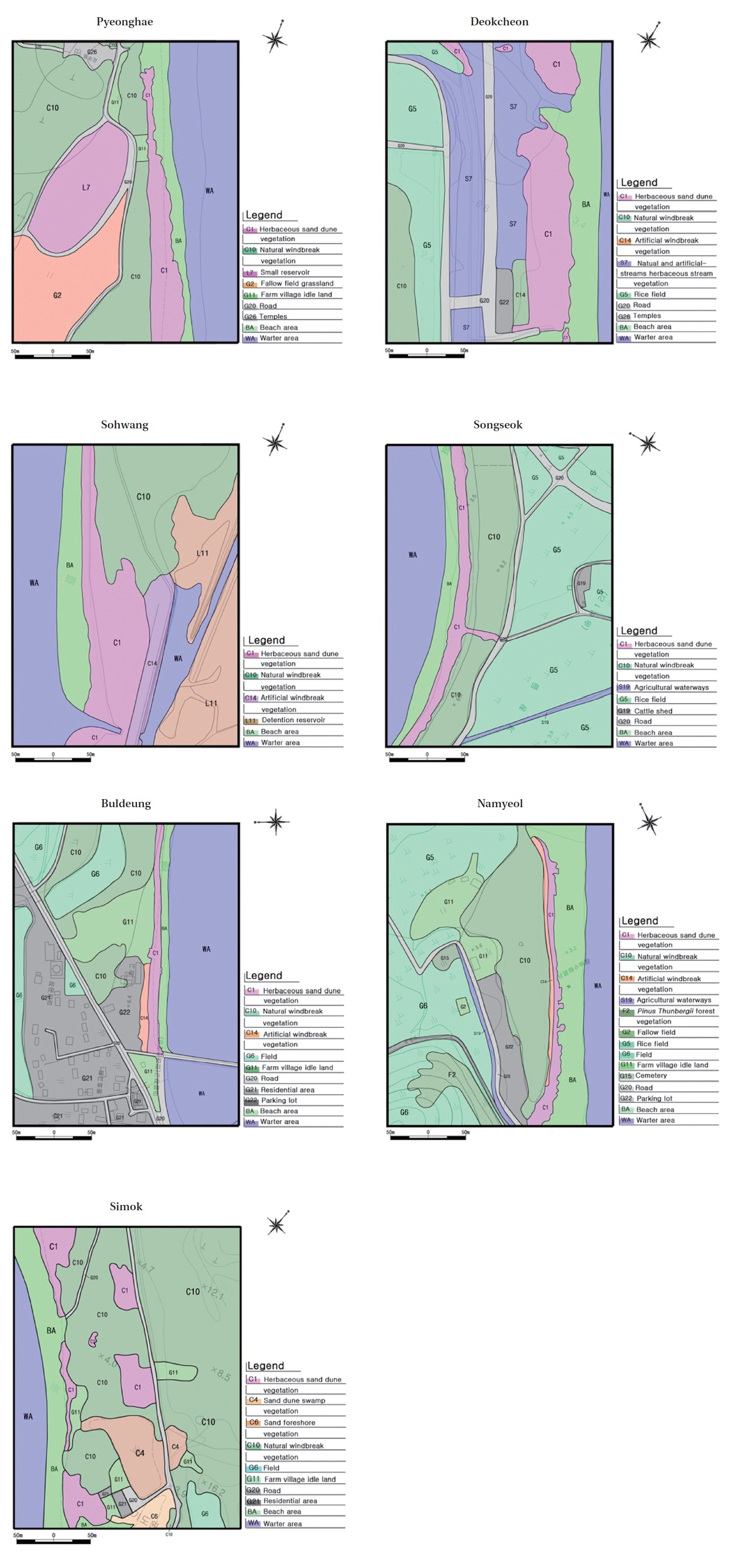
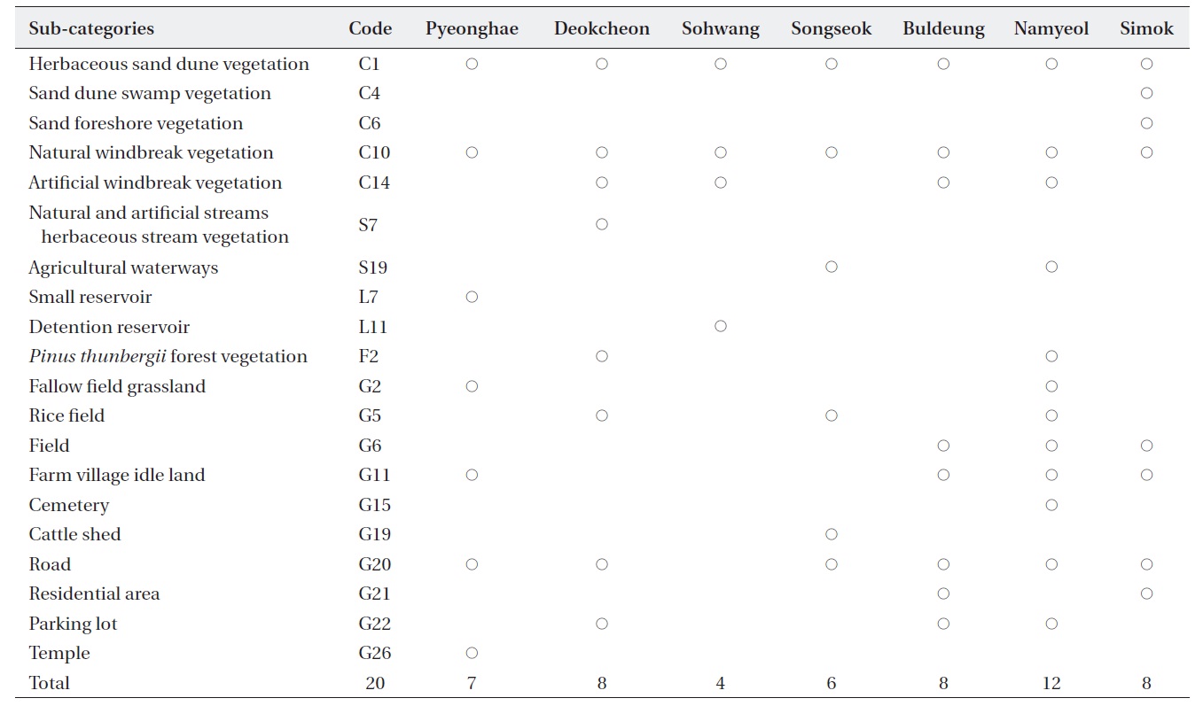
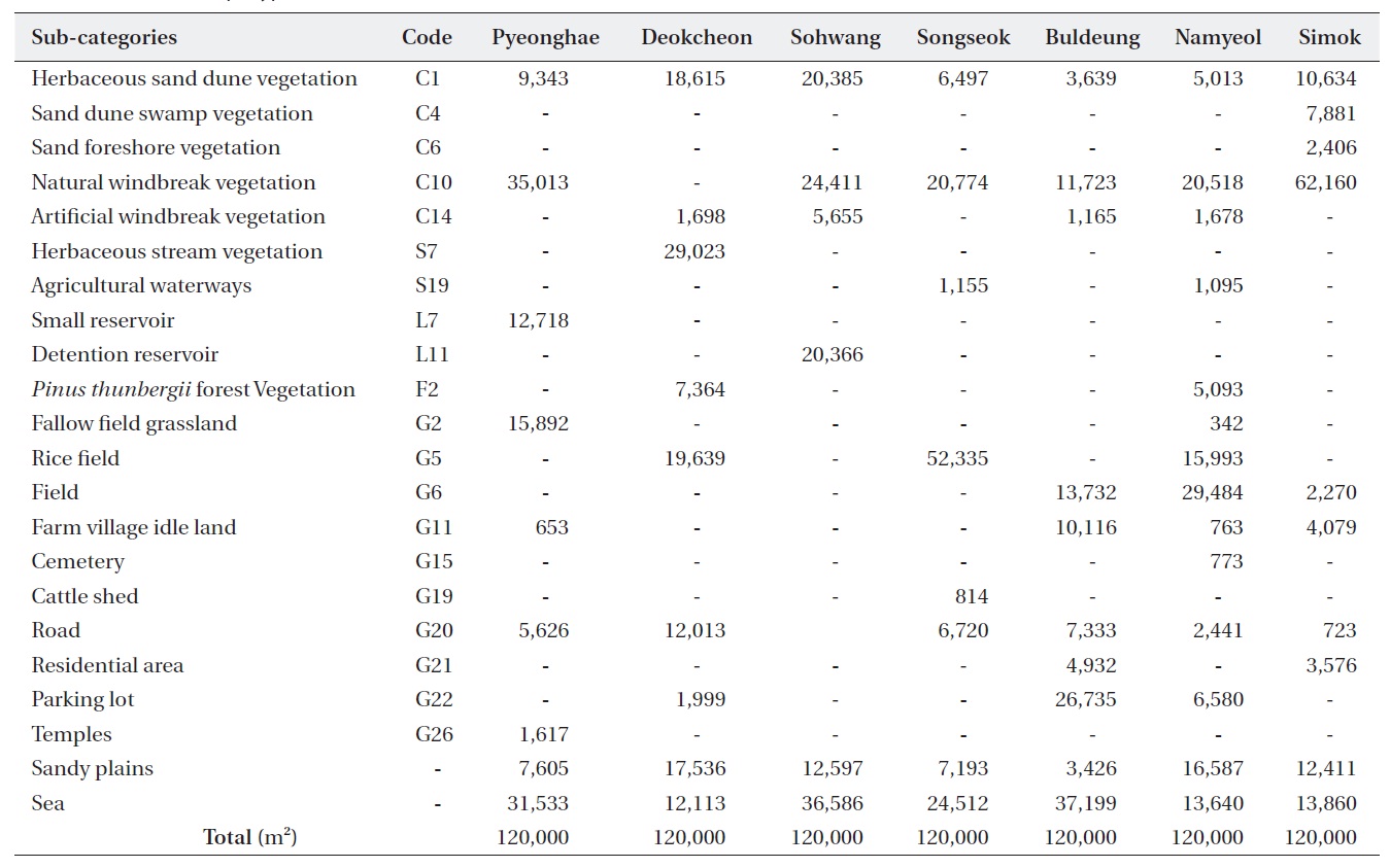
Biotope types were classified into 122 sub-categories, 49 low categories, 18 medium categories, and five high categories (Oh 2009). In the research areas, biotope types were categorized into 20 sub-categories, 12 low categories, 11 medium categories, and five high categories . The sub-categories were C1 (herbaceous sand dune vegetation), C4 (sand dune swamp vegetation), C6 (sand foreshore vegetation), C10 (natural windbreak vegetation), C14 (artificial windbreak vegetation), S7 (natural and artificial stream-herbaceous stream vegetation), S19 (agricultural waterways), L7 (small reservoir), L11 (detention reservoir), F2 (
The area of each biotope type was calculated for each research area (Table 3). Herbaceous sand dune vegetation was found in all of the research areas. The area of herbaceous sand dune vegetation was the highest in the Sohwang sand dune. In the hinterland of the sand dune, a high area of detention reservoir existed. The Simok sand dune had both a sand dune swamp vegetation and a sand foreshore vegetation. The Namyeol sand dune had the most biotope types, with a wide range of arable and idle land. In the hinterland of the Deokcheon sand dune, a stream flowed through it. This sand dune had herbaceous stream vegetation as well as roads in a larger range compared to the other sand dunes. The hinterland of the Pyeonghae sand dune had a small reservoir and fallow grasslands, widely.
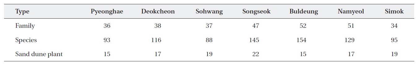
The vascular floras of our research were 77 family, 275 species. Among them, there were 12 family, 25 species of sand dune plants and 13 family, 40 species of naturalized plants (Table 4). The Buldeung sand dune and the Songseok sand dune had the most vascular floras. Since there was a forest behind the Buldeung sand dune, it had many species of vascular plant species. The Songseok sand dune had high areas of natural windbreak forest. Many plants thrived in the herbaceous sand dune vegetation. The most naturalized plants were distributed throughout the Buldeung sand dune. Sand dune plants were distributed most widely in the Songseok sand dune. However, since the sand dune was under high artificial interference by its hinterland, many land plants as well as sand dune plants existed.
A regression analysis, regarding the area of each biotope type among the evaluation categories, was per-
[Table 2.] Biotope classification in research areas

Biotope classification in research areas
[Table 3.] Area of biotope type in the research areas (m2)
Area of biotope type in the research areas (m2)
[Table 4.] Vascular flora of research areas on coastal sand dune

Vascular flora of research areas on coastal sand dune
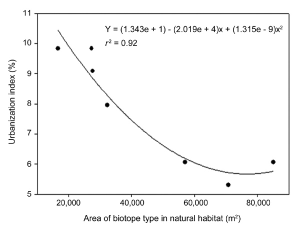
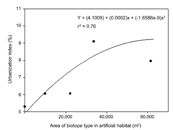
formed based on the urbanization index. First, the naturalization rate and the urbanization index were analyzed in each of the research areas. Then, a regression analysis regarding the area of each biotope type was performed. The relationship between the area of each biotope type and the urbanization index was analyzed in the research areas. The result turned out to be a positive and negative relationship. The result of the regression analysis, in regards to the urbanization index against the area of each biotope type, such as herbaceous sand dune vegetation and natural windbreak vegetation, was
As the area of biotope types, under artificial interference from rice field, field, road, idle land, and residential area, became higher in the hinterland of coastal sand dunes, the urbanization index also became higher. As the area of typical biotope types, such as sand dune vegetation and natural windbreak vegetation grew higher, the urbanization index got lower.
In face of the numerous threats endangering coastal habitats, a need for monitoring the habitats as well as positive management is essential. In this paper, biotope types are classified based on the vegetation map in order to categorize biotope types in the ecosystem of coastal sand dunes; the flora is examined from each biotope area as well. The naturalization rate and urbanization index are analyzed in each research area in order to analyze the validity of the urbanization index as an assessment index for the preservation value of the ecosystem. In the ecosystem of coastal sand dunes, the naturalization rate is high in road, residential, idle land, rice field, and field areas. In the study by (Choi et al. 2008), the distribution characteristics of naturalized species in each biotope type are analyzed. As a result, the naturalization rate is the highest in the residential area and idle land. In farm villages, the naturalization rate is high on rural dry streams among the rural streams. In village forests, the naturalization rate is high at graveyards, which is close to the coastal sand dunes. In addition, the aquatic ecosystem is evaluated based on the index of biological integrity (IBI), which is the multivariate biological integrity evaluation index. There are 10 evaluation indices as follows: the total number of native species, total number of riffle-benthic species, total number of sensitive species, number frequency of tolerant species, relative frequency of polyphagous fish species, relative frequency of moth-eaten fish species, relative frequency of carnivorous fish species, total number of species, relative frequency of introduced species, and abnormality frequency of species. Using these 10 evaluation indices, a quantitative evaluation has been performed (An et al. 2001). In the land ecosystem, biotope mapping for each biotope type has been evaluated. In the study performed by Choi et al. (2008), the distribution status of naturalized plants has been examined for each biotope type. The correlation between the use of land and the distribution of naturalized plants have been analyzed as well. In the land ecosystem, the naturalization rate greatly depends on the adjacent biotope environment as well as the use of land. Moreover, the distribution features of naturalized plants by biotope type are an index for the naturalness level evaluation of the land ecosystem. To assess conservation status in coastal dunes, Carboni et al. (2009) proposed a multiscale approach method in two stages one focusing on the landscape and the other on the plant community level. In the first phase, mosaic structure and composition of the coastal landscape are analyzed using a series of indicators: natural coastal surface, richness of land cover typologies, landscape diversity and evenness, number and average size of habitat patches, and mean shape index. At a detailed scale, floristic, vegetational, and structural aspects of the dune plant communities are analyzed along the main environmental gradient by measuring spatial connectivity and richness of boundaries, species diversity, evenness, and chorological index.
In this paper, a regression analysis regarding the area of each biotope type and urbanization index has been performed. As a result, when biotope types such as vegetation of roads, residential areas, idle land at farm villages, rice fields, and fields, which have artificial influence on coastal sand dunes, are widely distributed, the urbanization index grew higher. On the contrary, when biotope types, such as sand dune vegetation and natural