Water source protection zones are based on the “Drinking Water Act,” which was established to ensure the preservation of water supply sources. The first water protection zone was assigned in Pohang in 1962. Since then, 353 sites, with a total area of 1,290 km2, have been assigned and managed [1]. The designation and management of water source protection zones, to secure the safety of drinking water by restricting land use in upstream regions, seems to be one of the most desirable polices in terms of water quality preservation.
Currently, more than 90% of the water supply sources in Korea secure their water from surface water, such as river or lake water or via direct intake. However, interest in indirect intake from, for example, riverbank filtration, has recently arisen because of pollution and a reduction in the quantity of surface water. In cases of riverbank filtration, water is collected from a sediment layer adjacent to the riverbank, which is safer than the surface water in terms of water quality due to natural filtration. However, with the development and use of new chemicals, extremely small amounts of harmful substances have been found via tap water analyses. Tests have shown the detection of 20 out of 59 test items in tap water [2]. Even though the amounts detected were lower than those allowed by the World Health Organization or USA, considerable amounts were detected in the total amount of water used, which shows the importance of direct prevention. Therefore, this study intended to propose measures on the designation and management of protection zones to increase the number of indirect intake water sources, such as riverbank filtration.
2. Characteristics and Basic Composition of Indirect Intake
In Korea, most water is purified after it has been acquired through the direct intake of surface water. However, the merits of acquiring water through indirect methods--after the water has passed through soil particles, i.e. riverbed filtration--is superior in terms of water quality, regardless of the season. As indirect methods are applied in some regions, the assignment of water source protection zones and their proper management are required. Until now, there has been low demand for indirect intake as the result of over dependence on direct intake from water sources. Nevertheless, there is now demand for water source diversification in terms of water quality and quantity, and some local governments are expanding their development of riverbank filtration.
2.1. Definition of Riverbank Filtration
The indirect intake methods can be classified into riverbank filtration, riverbed filtration and artificial recharge. As riverbed filtration is similar to underflow water intake, due to the features of Korean river sediment, the application of the current standards is practical for underflow water intake. Since no infrastructure currently exists for artificial recharge in Korea, riverbank filtration was considered as the only indirect intake method in this study. Riverbank filtration is an intake method where surface water and ground water are collected from a river or lake and lifted into an excavated region adjacent to the water source.
Riverbank filtration is a method where water is sent by induction through a vertical well or horizontal collection well near the river. As the water passes through an alluvium layer, it is filtered and added to the ground water supply. The intake methods include the indirect induction and use of river water by developing a vertical tube well and using a radial collection well to take large amounts of ground water in relatively thin water-bearing deposits by excavating a radial tube well horizontally after excavating a large sized vertical tube well.
2.2. Merits and Demerits of Riverbank Filtration
The mechanisms of the riverbank filtration method are divided into mechanical filtration and chemical/biological filtration, to remove dissolved pollutants or pathogenic bacteria via adsorption or biochemical degradation, while being collected into a well which passes though sand or gravel. The merits of the riverbank filtration method include a stable and secure water quantity, buffering against water quality accidents, prevention of water temperature change and winter-sowing, and an increase in the service water treatment efficiency. When water passed through the alluvium layer, the quality of the water is significantly improved over that of the river water. For example, the biochemical oxygen demand can be reduced by 20-30% compared to river water.
On the other hand, riverbank filtration requires large amounts of capital to pay for facilities, electric power and maintenance. In addition, there are difficulties in treating water when the concentrations of pollutants, such as chlorine ions, are high. Furthermore, when the recharging areas are damaged by cultivation or contamination, the water quality is negatively influenced for a long time. However, despite these demerits, it is possible to oxidize ammonia through the use of microorganisms, even during winter, and the method provides high stability from unexpected water contamination in upstream regions, and a more even quality of water is obtained. In addition, floating matter and microorganisms are removed during the sedimentation, filtration and infiltration processes. It is possible to save costs in water purification by reducing the amount of water purifying chemical agents and simplifying the water purification process, as well as maintain eco-friendly facilities by reducing sludge generation.In terms of water quality, it is also possible to maintain the water quality during floods or droughts.
3. Estimation of Capture Zone for Protecting the Riverbank Filtration Intake
To estimate the capture zone for the protection of the riverbank filtration intake, precise geo-hydrological investigations and analytical data regarding the reduction and conversion in the process of the underground movement of pollutants should be considered. However, it seems to be almost impossible to set up an intake well protection zone, based on precise investigation, analysis and study for all intake wells distributed throughout the entire nation, in terms of work force, time and urgency of ground water pollution prevention. Hence, the introduction of a procedure to improve set-up of the intake well protection zone would be required.
3.1. Method to Set Up Intake Protection Zone for Riverbank Filtration Intakes
Riverbank filtration intakes can be established by dividing the zone into several areas according to the degree of prohibited activities and allowed pollutant discharge in areas around the intake well. In European Union member countries, which have operated the intake reservoir protection area using ground water as a source of water supply for a considerable time, the protection zones are generally classified into the 1st zone (primary protection zone, neighboring zone), the 2nd zone (secondary zone, neighboring zone) and the 3rd zone (water quality influencing effect, distant contact area) [3]. It has been judged necessary to consider the movement rate of ground water and the seriousness of restoration. General conditions for forming a boundary for setting up indirect intake water sources include distance, depression head and time of travel.
(1) Distance: A method of setting up a zone on a standard of certain distances from the intake well, which should be the most simple and clear option. However this method has a lot of voluntary features, with the disadvantage that it does not reflect or ignore the contents of the ground water flow.
(2) Depression head: A method of setting up a zone where surrounding depression heads caused by water intake into an intake well are over a prescribed scale
(3) Time of travel (TOT): A method that should be decided by considering the flow rate of ground water and a zone within a scope of reach. Time is decided after fixing the residence time within the intake well necessary for the protection of water quality. In these cases, the scope of time necessary for protecting water quality is not clear objectively; therefore, it is unavoidable that the time will sometimes be voluntary in order for the time to be set.
3.2. Capture Zone for Setting Up the Distance of the Protection Zone
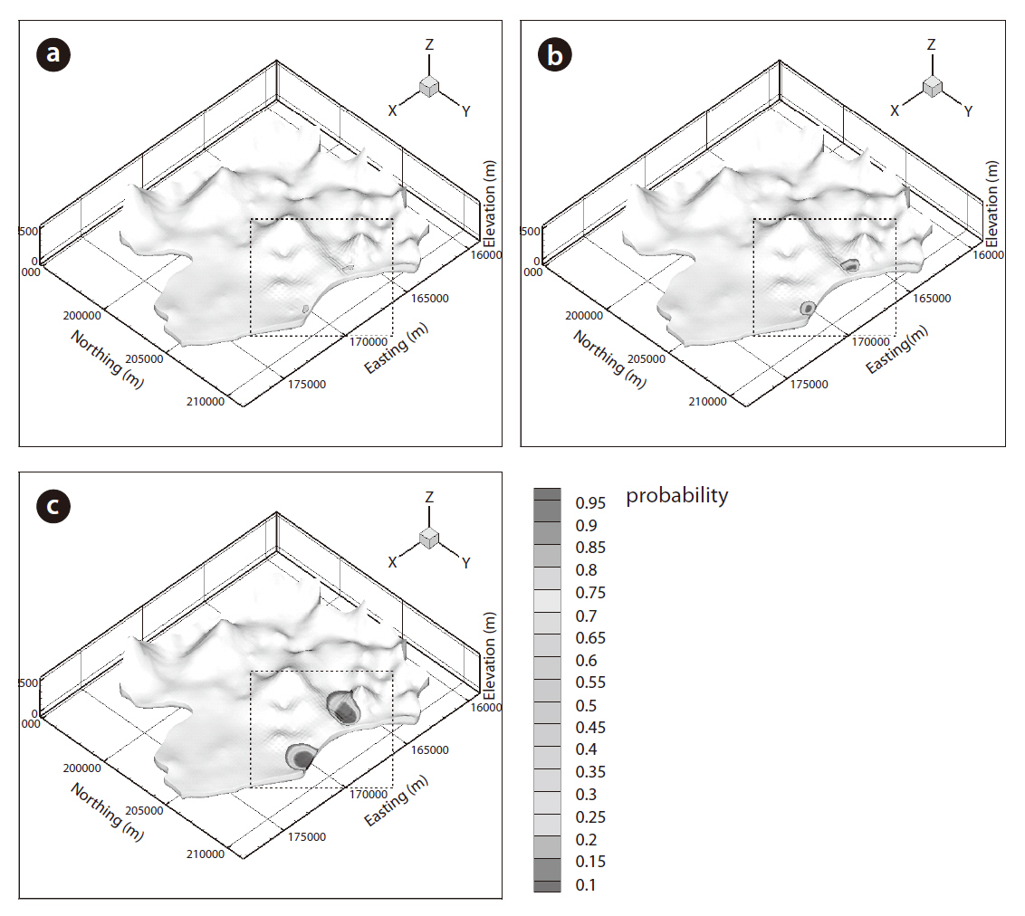
Here, a method to set up a protection area by applying the capture zone distance and the TOT was attempted methodically.In a three-dimensional assessment of the capture zone, which is necessary for setting up the intake well protection zone, a reverse equation tracing the transportation of a solute, which moves in the opposite direction to the groundwater flow, may be used. Using this approach, it is possible to perform probabilistic calculations of the time it takes for pollutants to reach the groundwater intake well. For the riverbank filtration groundwater intake well, the method of setting up the travel time capture zone was applied to the areas around the river filtration intake well group located in Kyeongsangnam-do. The travel time capture zone, and a capture zone of pollutants’ travel time to be entered into specific water supply wells, can be expressed as a cumulative probability density function integrating the travel time probability density function, as follows [4]:

where
3.2.1. Composition of the Model Zone
Modeling was performed to confirm how the travel time capture zone is set up at a site where a river bank filtration intake well is actually operating. For the model boundary, fixed head boundaries along with the river were given to the north and east,and impervious boundaries along with the mountain ridge were set up to the south and west. Based on the data obtained from the site, a simulation region was set up comprised of 4 layers, including 2 sediment layers of sand and gravels, a layer of weathered rock and a layer of bedrock. It was assumed that each layer had even hydrological features. As in the general regions HydroGeoSphere[5] 3 dimensional simulation of the ground water flow, transportation and reverse transportation was used.
3.2.2. Effects by Change of Hydraulic Conductivity
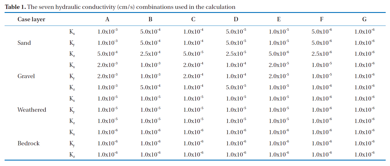
As in the case of a general area, changes in the size of the capture zone due to changes to the hydraulic conductivity of the sand and gravel layers, corresponding to the sediment layer
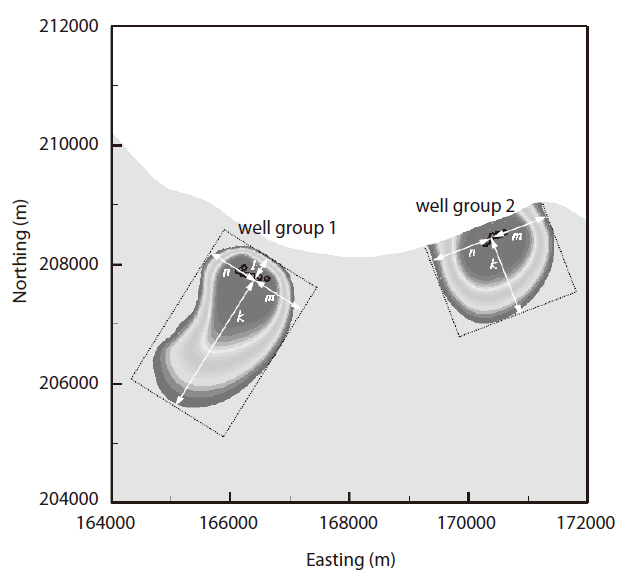
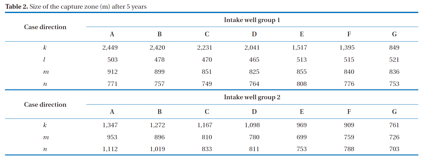
within the range 1×10⁻⁶~1×10⁻³ cm/s, were observed(Table.1). As shown in Fig. 1, the capture zone area was set to an area calculated to have more than a 5% probability of pollutant detection.(Eds note: a 5% probability of what? Please confirm.) Seven intake wells from the 2 intake well groups were established, giving a total of 14 intake wells. The quantity of water supplied by each intake well was 2,000 m3/day, resulting in a total water supply quantity of 28,000 m3/day. The simulation period was set at 5 years.
It was found that the hydraulic conductivity in the alluvium layer from cases A to G decreased and the capacity of the water-bearing deposit passing to the ground water was reduced.Hence, the capture zone that the intake well can influence also decreased. It should be noted that although the size of the capture zone was markedly reduced in direction, along with the flow of ground water, there was no significant change in the size of the direction across the flow of ground water. In addition, when the hydraulic conductivity value of the alluvium layer decreased, the hydraulic conductivity became similar to that of the rock layers and; in the case of G, where the value was extremely small and had almost no vertical difference, the capture zone was extended to the rock layer.
In order to observe changes to the capture zone range more precisely, the capture zone sizes after 1,825 days (5 years) were
measured for the 7 cases. As shown in Fig. 2, the capture zones were arranged by measuring the upstream length in the direction of the ground water flow, centering on an intake well,
As mentioned above, it was found that
Combining the results of the model, and when the hydraulic values were changed, it was found that the general size of the capture zone of the intake well also decreased. Furthermore, in cases where the hydraulic value was small, the size of the capture zone could be extended slightly in the vertical and horizontal directions.
Simply put, it was concluded that capture zones with large hydraulic conductivities included all capture zones. With small protection areas, there is a risk that pollutants could enter the intake well through unexpected channels. Therefore, a compre-
[Table 1.] The seven hydraulic conductivity (cm/s) combinations used in the calculation
The seven hydraulic conductivity (cm/s) combinations used in the calculation
[Table 2.] Size of the capture zone (m) after 5 years

Size of the capture zone (m) after 5 years
hensive investigation and analysis of the geo-hydrological features at the site must be conducted in order to set up the capture zone properly.
4. Estimation and Management Measures of the Riverbank Filtration Intake Source Protection Zone
Because the development of water-bearing deposits in Korea is insufficient, it is actually very difficult to secure indirect intake sources, such as riverbank filtration. However, in the future,the need to develop and manage indirect intake will increase, even on a small scale; therefore, measures for the assignment and management of indirect intake source protection zones are necessary.
4.1. Proposal of Scope for Riverbank Intake Source Protection Zones
In assigning a water source protection zone, riverbank infiltration should be approached from a different perspective than ground-surface water, and in estimating the scope of the protection zone, the concept of time of travel should be treated as having the most importance. In addition, because riverbank filtration has a very low flow velocity, once it becomes contaminated, its treatment is impossible or very time consuming. Hence, it is more important to prevent such contamination in advance by controlling the regions adjacent to the intake source more strictly and dividing the source in steps. The groundwater in Korea is divided into 3 steps, but this study intended to propose appropriate steps based on assigning methods that consider existing protection zones, such as river water and underflow water.
The indirect intake method is comprised of riverbank filtration,riverbed filtration and artificial recharge, and with regard to Korea, riverbank filtration has been adjudged to be the best possible method. With riverbed filtration, there is no significant difference with underflow water when the thickness of the alluvium layer is considered. Accordingly, it is desirable to apply the same standards to riverbed filtration that are applied to underflow water. In the case of groundwater and riverbank filtered water, the 1st zone is commonly applied to all intake sources,with the 2nd zone applied differently based on the intake quantity,water quality and development conditions.
When assigning the riverbank filtered water protection zone,it is generally accepted that the time of travel should be considered. The time of travel of riverbank filtered water depends on the geographical conditions, particularly the thickness of the alluvium layer. The thickness of the alluvium layer in Korea is about 20% that found in Europe and America. Even when converted by the most conservative and simple equation, the im-
[Table 3.] Criteria and basis for assigning the riverbank intake source protection zone
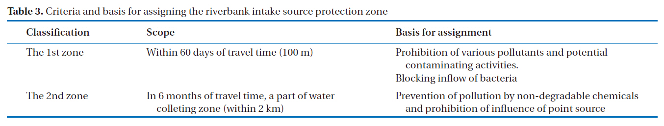
Criteria and basis for assigning the riverbank intake source protection zone
pact of pollution can be as much as 5 times faster. Therefore, the protection zones in Korea should be five times larger than those in Europe and America.
In the estimation of protection zones, the time of travel and distance standards should be considered. Using complex calculation equations, such as the flow of groundwater with the time of travel, the nature of soil and fluctuations in the underground water level, it is possible to estimate an appropriate distance. However, due to practical difficulties in these types of estimation,it is not even used in foreign countries, with distance criteria at the intake well most commonly used. Therefore, it is desirable for the 1st and 2nd zones to be classified based on the distance around the intake well(Table 3).
The 1st zone is generally a region just around the intake well. If pollutants are introduced into this zone, it could seriously affect the water quality in the intake well. Therefore, activities that could potentially release pollutants should be prohibited, and the installation of facilities that would possibly release pollutants should be forbidden. Although it is difficult to decide upon a scope, voluntary decisions can be made for more convenient management. It is presumed that it is possible to recognize and respond to quarter quality problems for periods of 1-2 months; therefore, it would seem sufficient that problems from an approximate 100 m radius could be fixed in a range of more than 60 days intake based on the intake water quality, and the depth and pore space ratio.
For the 2nd zone, 2 cases were considered. The first case involved setting up a scope to manage pollutants capable of being reduced naturally. Assuming the limited inflow of pollutants could be reduced to within drinking water standards during an underground retention time of 6 months, some activities, such as cultivation, could be allowed. For this, the scope could be set to a zone of about a 400 day intake range and within a distance of 500 m. For the 2nd zone, living activities are allowed, but they should be managed by setting up a marginally allowable pollutant load
In regions where it is impossible to reduce pollutants naturally, it is unavoidable that pollutants will affect the groundwater from the intake well sometime later. However, considering a practical execution force, a 2 km protection zone should be established.
4.2. Proposal of Protection Zone Management Measures
For the management of riverbank intake sources, it is necessary to reflect on the special features of the riverbank filtered water in order to draft management measures. Although some differences exist in assigning the scope of the protection zone, their consistent management is desirable. Because riverbank filtered water has a larger intake capacity and faster movement velocity,it would seem appropriate to manage them at the same level.
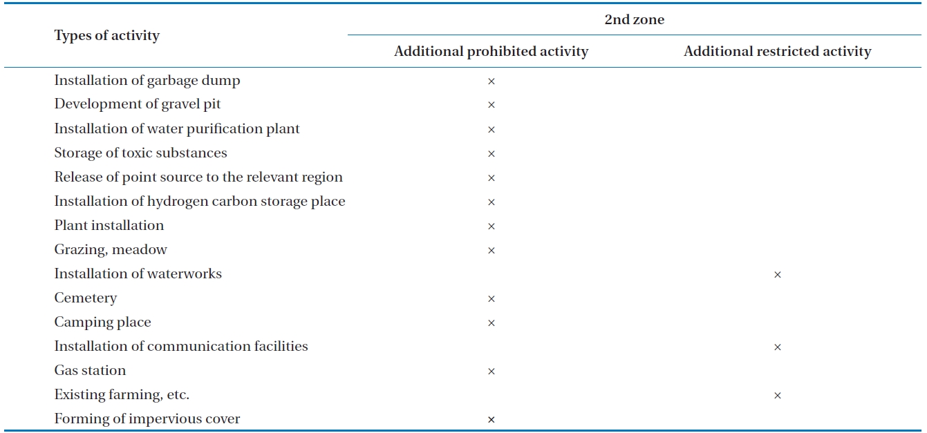
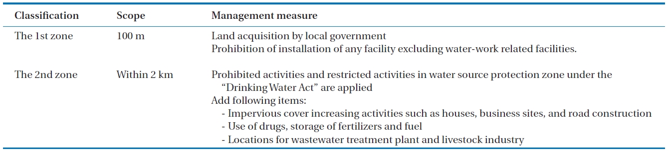
In the case where the water source protection zone is assigned to the river filtration intake source, it is appropriate to purchase and manage the 1st zone. When the purchase of the 1st zone is impossible, it should be managed as though it were purchased. With regard to the 2nd zone, existing prohibited and restricted activities within the water source protection zone should be applied, and some of these activities should be added after considering the special features of the groundwater and riverbank filtered water(Table 4).
On the basis of existing regulations, for ground-surface water intake source protection and the movement of pollutants in the indirect intake method, the following activity regulations are proposed:
4.2.1. Measures for 1st Zone Management
The 1st zone should be managed by purchasing the land and making it off-limits. It should be protected by wire entanglements and all activities and facilities should be strictly prohibited.
4.2.2. Measures for 2nd Zone Management
[Table 4.] Management measures by riverbank filtration protection zones
Management measures by riverbank filtration protection zones

Additional prohibited and restricted activity for riverbank intake source protection zones
The 2nd zone can include areas as large as 2 km. Therefore, the zone should block pollutants that cannot be naturally reduced, and while agricultural cultivation and living activities are allowed, the discharge of special pollutants should be prohibited.With regard to pollutants capable of natural reduction, their management and control are required. In addition, the following factors should be prohibited(Table 5):
With the increased discharge of pollutants, due to increased economic and development activities near upstream water sources, the necessity for positive management measures has become more important than ever. Moreover, because there is a considerable time difference between the discharge of pollutants and the result of their impact on the environment, it is difficult to confirm the correlation between the damage, and the importance of prior prevention measures for the regions adjacent to the intake source. Therefore, the riverbank filtration method, which is being developed as a new source for water, should ensure the protection of the water source. The 1st zone for the
protection of the riverbank filtration intake should be managed through the purchase of land by the operator, with the installation of various facilities strictly prohibited. The 2nd zone should be appropriately managed in order to avoid pollutants from entering the area and activities should be restricted.
The major premise is that indirect intake, including riverbank filtered water, should be protected from drying up and becoming contaminated in order for it to be used efficiently. However, issues regarding how the water should be correctly managed have raised a number of practical difficulties.
This is because the data used in the application and execution of policies and regulations are insufficient, as well as there being a number of unknown factors that affect the underground flow. Despite the unclear situation, protection zones should be chosen and managed properly, because the situation can not be ignored. The management of the water quality from indirect intake should be efficient when based on various data and analyses. Efforts for obtaining, researching, developing and analyzing these data must be considerably strengthened compared to those currently being exercised. Despite the insufficient data and development, this study has proposed criteria for assigning and managing indirect intake protection zones. As riverbank filtration water relies on a certain number of conditions, the propositions in this study should be the minimum criteria and management measures necessary.